*Corresponding Author: Mark D. Powell E-mail: Mark.Powell@noaa ...
*Corresponding Author: Mark D. Powell E-mail: Mark.Powell@noaa ...
*Corresponding Author: Mark D. Powell E-mail: Mark.Powell@noaa ...

Create successful ePaper yourself
Turn your PDF publications into a flip-book with our unique Google optimized e-Paper software.
13D.1<br />
UNCERTAINTY IN HURRICANE WINDS: WHAT DO NEW MEASUREMENTS AND SIMULATIONS TELL US ABOUT<br />
HURRICANE ANDREW<br />
<strong>Mark</strong> D. <strong>Powell</strong> 1<br />
NOAA-AOML Hurricane Research Divison, Miami FL 33149<br />
Jeff D. Kepert<br />
Australian Bureau of Meteorology, Melbourne AUS<br />
Auguste Boissonade<br />
Risk Management Solutions, Menlo Park, CA<br />
Peter J. Vickery<br />
University of Western Ontario, London, ON CAN<br />
1. INTRODUCTION<br />
The Best Track committtee of the Tropical Prediction<br />
Center recently reclassifed Hurricane Andrew as a<br />
Category 5 storm at landfall in South Florida, based on<br />
an interpretation (that peak surface winds are ~ 90%<br />
of the flight-level winds at the 700 mb level) of open<br />
ocean GPS sonde measurements made since 1997.<br />
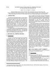
2. VARIABILITY OF REDUCTION FACTORS<br />
The uncertainty of applying a single mean flight-level<br />
wind reduction factor (R) is high, as evidenced by the<br />
large standard deviation of 0.19 (Franklin et al 2003).<br />
When the reduction factor distribution is further<br />
constrained to represent 700 mb winds above 50 m/s,<br />
there are only 30 samples and R falls to 77% with a<br />
15% standard deviation. R is known to vary radially<br />
within a storm (Franklin et al 2003) in agreement with<br />
other observations (Mitsuda 1988, <strong>Powell</strong> et al.,<br />
1996), theory (Kepert 2001) and idealized modeling<br />
(Shapiro 1983, Kepert and Wang 2001). Theory and<br />
models show a motion-induced left-right asymmetry,<br />
with higher SWF on the weak (left) side of the storm.<br />
Franklin at al (2003) also noted that R on the left side<br />
was on average 4% larger than the right; remarkable<br />
considering that 439 eyewall profiles in 17 storms<br />
were considered. This behavior was observed in<br />
Keperts (2002a,b) analyses of R in Andrew and<br />
Georges but is not present in all cases, possibly<br />
because other sources of asymmetry (e.g. shear) can<br />
dominate at times. Kepert (2001) shows a 10%<br />
variation in R dependent on inertial stability in the<br />
eyewall, which can vary greatly between storms, and<br />
may be the reason for the variability depicted in Fig.<br />
11 of Franklin et al., (2003).<br />
Recent measurements from the Stepped Frequency<br />
Microwave Radiometer (SFMR) suggest that in<br />
individual storms, R may follow an asymmetric pattern<br />
influenced by relative flow patterns associated with a<br />
storm passing through a sheared environment. Near<br />
<strong>*Corresponding</strong> <strong>Author</strong>: <strong>Mark</strong> D. <strong>Powell</strong><br />
E-<strong>mail</strong>: <strong>Mark</strong>.<strong>Powell</strong>@noaa.gov<br />
peak intensity, Hurricane Isabel of 2003 provided<br />
evidence of this feature (700 mb winds of 70-75 m/s<br />
approached those measured in Andrew. A research<br />
flight on the 12th encountered low (0.75) reduction<br />
factors, with the W side slightly higher than the E<br />
side, the S side higher than the N side, and later in<br />
the flight the E and W sides about the same.<br />
Measurements 24 h later showed similar R ahead and<br />
behind the storm but higher factors to the left (SW)<br />
and lower to the right (NE) side.<br />
3. CHARACTERISTICS OF INTENSE HURRICANES<br />
Unfortunately, none of the storms in the GPS sonde<br />
database, including Mitch when a Cat 5, show 700 mb<br />
winds as high as Andrew (~82 m/s). Earlier storms<br />
showing 700 mb winds similar to Andrew include Inez<br />
(Hawkins 1969), Allen in 1980 (on Aug 8th after an<br />
eyewall contraction, Jorgensen 1984), Gloria 1985 at<br />
peak intensity (peak tangential winds at 550 mb<br />
although the distribution of convection in Gloria was<br />
asymmetric due to shear of the environmental flow<br />
(Franklin et al., 1993)), Gilbert of 1988 near peak<br />
intensity (Dodge at al.,1991), and Hugo in 1989<br />
(Black and <strong>Mark</strong>s 1991). Characteristics of such<br />
Intense hurricanes include a contracting eyewall<br />
process and winds at 700 mb that are as strong as<br />
winds at 500 m. This is in contrast to the usual<br />
situation where the winds at 700 mb are of the order<br />
of 10 - 30% lighter than those at 500 m (e. g. Franklin<br />
et al's fig 11). An eyewall with little vertical shear<br />
below flight level would thus contribute to smaller<br />
values of R.<br />
4. COMPARISON OF 0.9 RULE TO SURFACE WIND<br />
OBSERVATIONS IN ANDREWÕS EYEWALL<br />
Anemometers in Andrews eyewall failed to sample<br />
complete records but provide a valuable opportunity to<br />
validate the 0.9 rule. At 0759 UTC, 24 August 1992,<br />
the Fowey Rocks C-MAN station measured a maximum
sustained surface wind of 108 kts (<strong>Powell</strong> et al.,<br />
1996). The data transmission system failed soon<br />
afterwards, followed by the instrument mast (Personal<br />
communication, Doug Scally 2002). An objective<br />
analysis of the North-South and East-West legs of the<br />
700 mb flight-level observations from 0410-0830 UTC<br />
adjusted using the 0.9 rule results in ~140 kt winds at<br />
Fowey Rocks, over 30 kts higher than observed. The<br />
highest surface wind measurement in Andrew, 119 kts<br />
(<strong>Powell</strong> et al., 1996) came from a Perrine homeowner,<br />
using a 10 m mast attached mounted near the side of<br />
his house. The mast failed at the time of this<br />
measurement consistent with an east (Mayfiield et al.,<br />
1994) or eastnortheast wind direction. As discussed<br />
in <strong>Powell</strong> et al., 1996, the most likely time of this<br />
observation was ~ 0900 UTC. The 0.9 R objective<br />
analysis at 0900 UTC shows ~ 142 kts in Perrine,<br />
over 20 kts higher than observed. These<br />
comparisons indicate that the 0.9 method used to<br />
adjust the 700 mb flight-level winds to the surface<br />
overestimated winds in these locations by ~29% and<br />
19%, respectively. If we use the 0.9 rule to estimate<br />
flight-level winds from the surface measurement, the<br />
700 mb winds would be ~120 and 132 kts above<br />
Fowey Rocks and Perrine, respectively compared to<br />
actual flight-level measurements of 156 kts and 162<br />
kts at the same radius. Using an R of .77 yields a<br />
700 mb wind estimate of 140 kts and 155 kts above<br />
Fowey and Perrine, respectively which compares<br />
much better with the observations.<br />
5. INSURANCE INDUSTRY SIMULATIONS<br />
From an insurance industry point of view, the<br />
maximum wind speed alone may not be the best<br />
measure of risk or damage potential; the spatial wind<br />
hazard impact on properties is much more important.<br />
However, models typical of those used by the<br />
insurance industry (Vickery et al 2000) attempt to<br />
reproduce hurricane surface wind fields with published<br />
accuracies of within 15%. With input parameters<br />
based on Hurricane Andrews observed minimum<br />
pressure (922 mb), radius of maximum wind (19 km),<br />
translation speed (10 m/s), and pressure profile<br />
(derived from Fig. 4 of Mayfield et al., 1994), such a<br />
model is able to reproduce a maximum wind speed<br />
range of 118-123 kts. It is not possible to reproduce<br />
a wind speed of 150 kts without using unrealistic<br />
values for the pressure profile.<br />
6. COASTAL ROUGHNESS<br />
Another plausible reason for the overestimate of the<br />
90% rule may have to do with the exposures of the<br />
GPS sonde surface wind measurements upon which it<br />
is based. As discussed in <strong>Powell</strong> et al (2003), nearly<br />
all the sondes were launched in deep-water, openocean<br />
conditions. The aerodynamic roughness of the<br />
sea in such conditions was shown to have very small<br />
values ~ 1 mm. Near the coast, recent observations in<br />
Hurricane Bonnie (Walsh et al., 2002) document<br />
shorter and steeper swell, and other researchers have<br />
noted larger roughness lengths due to shoaling wave<br />
conditions. Unfortunately there are too few GPS<br />
sonde wind profiles near the coast to make this<br />
distinction. However, university teams have<br />
participated with the annual HRD field program and<br />
have begun to collect detailed wind measurements<br />
from instrumented coastal towers deployed ahead of<br />
hurricanes. A particularly interesting set of<br />
measurements was collected by Reinhold and Gurley<br />
(2003) as part of Clemson and the University of<br />
Floridas participation in the Florida Coastal Monitoring<br />
Program (http://www.ce.ufl.edu/~fcmp). Onshore flow<br />
roughness measurements within 200 m of the<br />
(prestorm) shoreline were recently obtained at Cape<br />
Hatteras, NC during the landfall of Hurricane Isabel.<br />
These measurements document roughness more than<br />
an order of magnitude larger than open ocean<br />
roughness in similar wind speeds. Further<br />
measurements are needed to see if this behavior<br />
persists for winds greater than a Saffir-Simpson<br />
category two hurricane, but these data suggest that<br />
coastal roughness is similar to open terrain conditions<br />
over land (~ 30 mm) and much rougher than open<br />
ocean conditions. A rougher surface near the coast<br />
would contribute to weaker surface winds and smaller<br />
values of R.<br />
7. CONCLUSION<br />
Observations, theory and modelling studies support<br />
the fact that the surface wind reduction factor varies<br />
both within, and between, storms. Careful analysis of<br />
the observations in Andrew suggests that R near the<br />
right eyewall lies at the lower end of the possible<br />
eyewall range suggested by these studies. Thus,<br />
Andrew was most probably not a cat 5 at landfall.<br />
8. REFERENCES<br />
Black and <strong>Mark</strong>s, 1991, 19th AMS Conf. on<br />
Hurricanes, 11A.3, 579-582.<br />
Dodge, Burpee, and <strong>Mark</strong>s, 1991, Preprints, 19th AMS<br />
Conf. on Hurricanes, 15A.2, 551-552.<br />
Franklin, Black, and Valde, 2003, Wea&Fcst.18,32-44.<br />
Franklin, Lord, Feuer, and <strong>Mark</strong>s, 1993, Mon. Wea.<br />
Rev., 121, 2433-2451.<br />
Hawkins and Imbembo, 1976, Mon. Wea. Rev., 104,<br />
418-442.<br />
Jorgensen, 1984, J. Atmos. Sci, 41, 1287-1311.<br />
Kepert, 2001, J. Atmos. Sci, 58, 2469-2484.<br />
Kepert and Wang, 2001, J. Atmos. Sci., 58, 2485-<br />
2501.<br />
Kepert 2002a, Preprints, 25th AMS Conf. on<br />
Hurricanes, 16A.7, 615-616; 2002b PhD thesis.<br />
Mayfield, Avila, and Rappaport, 1994, Mon. Wea.<br />
Rev., 122, 517-538.<br />
Mitsuda, Suenobu, and Fujii, 1988, J. Meteor. Soc.<br />
Japan, 66, 505-508.<br />
<strong>Powell</strong>, Houston, and Reinhold, 1996, Wea&Fcst, 11,<br />
304-349.<br />
<strong>Powell</strong>, Vickery, and Reinhold, 2003, Nature, 422,<br />
279-283.<br />
Shapiro 1983, J. Atmos. Sci, 40, 1984-1998.<br />
Vickery, Skerlj, and Twisdale 2000, J. Struct. Engnr.,<br />
126, 1203-1222.<br />
Walsh and investigators, 2002, J. Phys. Ocean., 32,<br />
1667-1684.