united states - Alaska Division of Geological & Geophysical Surveys ...
united states - Alaska Division of Geological & Geophysical Surveys ...
united states - Alaska Division of Geological & Geophysical Surveys ...
Create successful ePaper yourself
Turn your PDF publications into a flip-book with our unique Google optimized e-Paper software.
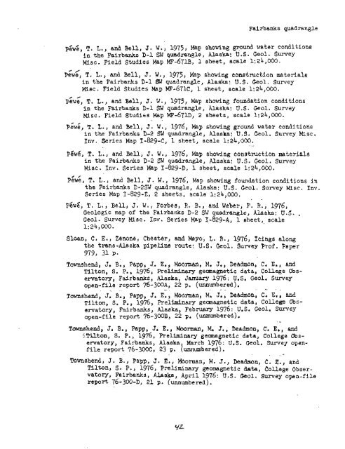
Fairbanks quadrangle<br />
P&&, T. L,, and Bell, J. W., 1975, Map showing grpund water caditions<br />
in the Fairbanks D-1 SU quadrangle, <strong>Alaska</strong>: U.S. Geol. Survey<br />
Misc. Field Studies Map MF-671~) 1 sheet, scale 1:24,000.<br />
@ /<br />
Pewe, T. L., and Bell, J. W., 1975, Map showing cbnstmction material~<br />
in the Fairbanks D-1 SW quadran@, <strong>Alaska</strong>: U.S. Geol. Survey<br />
Misc. Field Studies Map KF-671C, 1 sheet, scale 1:24,000.<br />
PGWZ, T. L., and Bell, J. W., 1975, Map showing foundation conditions<br />
in the Fairbanks D-1 SW quadrangle, <strong>Alaska</strong>: U.S. Geol. Survey<br />
Misc. Field Studies Map MI?-67~3, 2 sheets, scale 1:24,000.<br />
. .<br />
P&;, T. L., and Bell, J. W., 1976, Map showing ground wake? conditions<br />
in the Fairbanks D-2 SW quadrangle, <strong>Alaska</strong>: U.S. Geol. Survey Misc.<br />
Inv. Series Map I-8294, 1 sheet, scale 1:24,000.<br />
- ...<br />
Pgw6, T. L., and Bell, J. W., 1976, Map showing censtructian materials<br />
in the Fairbanks D-2 SW quadrangle, <strong>Alaska</strong>: U.S. Geol, Survey<br />
Misc. Inv. Series Map I-829-D, 1 sheet, scale 1:24,000.<br />
P~w;, T. L., and Bell, J. W., 1976, Map shewing foundation conditions in<br />
the Fairbanks C-2% quadrangle, <strong>Alaska</strong>: U.S. Geol. Sulvey Misc. Inv.<br />
Series Map 1 -829-E, 2 sheets, scale 1:24,000.<br />
~6~6, T. L., Bell, J. W., Forbes, R. B., and Weber, F. R., 1976,<br />
Geologic map <strong>of</strong> the Fairbanks D-2 SW quadrangle, <strong>Alaska</strong>: U.S. ,<br />
Ceol. Survey Misc. Inv. Series Map I-829-A, 1 sheet, scale<br />
1: 24,000.<br />
Sloan, C. E., Zenone, Chester, and Maya, L, R,, 1976, Icings along<br />
the tmns-<strong>Alaska</strong> pipellne route! U.S. Geol. Survey Pr<strong>of</strong>. Paper<br />
979, 31 P.<br />
Townshend, J. B., Phpp, J. E., Moorman, M, J., Dehdmon, C. Ern, and<br />
Tilton, S. P., 1976, Preliminary geamagnetic data, College Observatory,<br />
Fairbanks, <strong>Alaska</strong>, January 1976: U.S, Geol, Survey<br />
open-file report 76-~WA, 22 p. (unnumbered).<br />
.. ,, . , .. ,. ,, ", . .<br />
Tmshend, J, B., Papp, J, E. , MoOrmatl, M. J., Dcahon, C. E*,<br />
~ilton, S, P., 1976, Pre1lmha-y geomagnetic data, college Observat<br />
ory , Fairbanks, <strong>Alaska</strong>, February 1976 : U, S . Geol, Survey<br />
open-file rep<strong>of</strong>t 76-300B, 22 p. (umbered).<br />
. -<br />
Tmshend, Jr B.? Papp, J, E,, Wrman, M. J., Deadon, C. El, and<br />
i.Tilton, S. P., 1976, Preliminary geagnetic data, College Observatory,<br />
Fairbanks, <strong>Alaska</strong>, March 196: U.S. Geol. Swey openfile<br />
report 76-300~, 23 p. (umbered).<br />
. ,<br />
mmshend, J. B., Papp, 3. E., Moorman, M. J., habn, C. E., and<br />
Elton, S- P-, 1976) PnUminary geomagnetic bta, college Obser-<br />
vatory, Fairbad$, Uska, April 1976: U.S. kol. Sunrey open-file<br />
repod 76-300-~, 21 p. (unnumbered).


