united states - Alaska Division of Geological & Geophysical Surveys ...
united states - Alaska Division of Geological & Geophysical Surveys ...
united states - Alaska Division of Geological & Geophysical Surveys ...
Create successful ePaper yourself
Turn your PDF publications into a flip-book with our unique Google optimized e-Paper software.
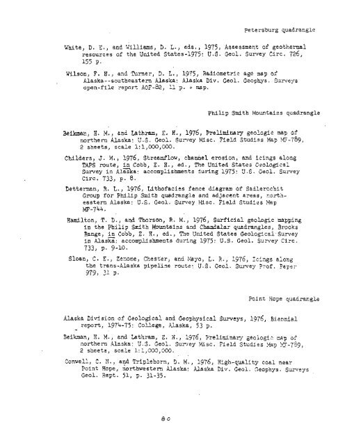
Petersburg quadrangle<br />
White, D. 2.) and iillisms, D. 3.) ecls., 1975, Assessment <strong>of</strong> gcothamal<br />
resources <strong>of</strong> the United States-1975: U.S. Geol. Surrey Circ. 726,<br />
155 P*<br />
Wilson, F. H., and Tamer, D. L., 1975, Radiometric age nap 02<br />
<strong>Alaska</strong>--mutheastern <strong>Alaska</strong>: <strong>Alaska</strong> Div. Gaol, Geophys. <strong>Surveys</strong><br />
open-file regort A03-82, 11 g, i nap.<br />
Phillp Smith Mountains quadrangle<br />
Bikman, H. M., and Lathram, E. H., 1976, P'reliminary geologic map <strong>of</strong><br />
northern <strong>Alaska</strong>: U.S. Geol. Surrey msc. Field Studies Mag 2~-789,<br />
2 sheets, scale 1: 1,000,000.<br />
Childers, J. M, , 1976, Streedlow, chaMel erosion, and icifigs along<br />
TAPS route, in Cobb, Z. H., ed., The United States C-eologlcsi<br />
Surrey in ~laska: accomplishments during 1975: V.S. Geal. Survey<br />
circ. 733, p. 8.<br />
Detteman, 2, L., 1976, Lithafatits fence diagram <strong>of</strong> Sacilercchit<br />
Group for Philip Smith quad-rangle and adJacent areas, 23rtheastern<br />
<strong>Alaska</strong>: U.S. Geol. Su~rey bfisc. Field Studies Hap<br />
MF-744.<br />
Hamilton, T. D., and Thorson, R. M., 1976, Surficial geohgic mapping<br />
in the Philip Sdth Mountains snd Chandalar quadrangles, Brooks<br />
Range, in Cobb, E. H., ed., Tne United States <strong>Geological</strong> Survey<br />
in <strong>Alaska</strong>: accomplishments dul'ing 1975: U.S. Geol. Suivey Circ.<br />
733, P. 9-10.<br />
Slban, C. E., Zeaone, Chester, and !&yo, i. 3., 1976, IeF;.4s along<br />
the trans-<strong>Alaska</strong> pipeline rout2: U.S. Geol. Survey ??<strong>of</strong>. ?a~er<br />
979, 21 9.<br />
Point Rope qiadrangl2<br />
<strong>Alaska</strong> <strong>Division</strong> <strong>of</strong> <strong>Geological</strong> and <strong>Geophysical</strong> Surttys, 1978, Biennial<br />
report, 1974-75: College, Usska, 53 p.<br />
-<br />
Beiknan, 9. M., and Lathram, 2, ii., 1976, Prelircina,r3r geologi nep <strong>of</strong><br />
northern <strong>Alaska</strong>: 3.8. Gzol. Sur~ey tilsc. Field Stcdies Rap E-759,<br />
2 sheets, scale 1: 1,000,300.<br />
, .<br />
Conwell, C. 11.) and Triplehorn, 3, M., 1976, High-quality coel near<br />
Point Hope, ikl-thwestern <strong>Alaska</strong>: Uaska Div. Geol. Seophys. Suneys<br />
Geol. Rept. 51, p. 31-35.


