united states - Alaska Division of Geological & Geophysical Surveys ...
united states - Alaska Division of Geological & Geophysical Surveys ...
united states - Alaska Division of Geological & Geophysical Surveys ...
You also want an ePaper? Increase the reach of your titles
YUMPU automatically turns print PDFs into web optimized ePapers that Google loves.
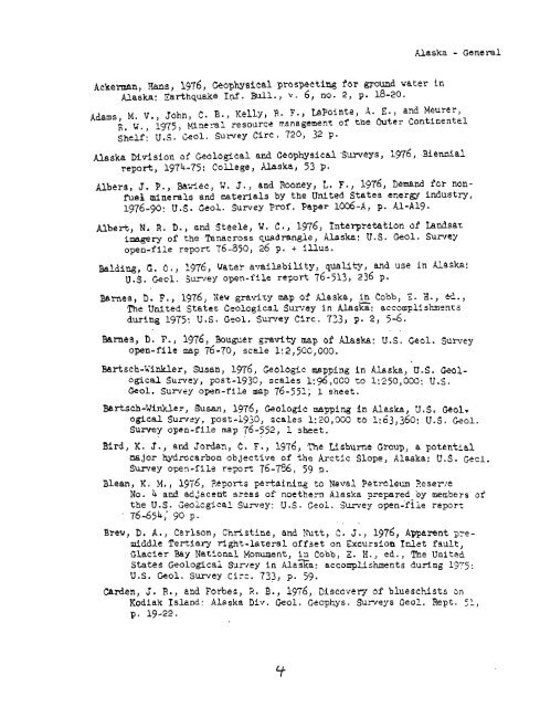
Ackennan, Hans, 1976, <strong>Geophysical</strong> prospecting for mud vater in<br />
<strong>Alaska</strong>: Earthquake Inf. Bull., v. 6 , no. 2, p. 18-20,<br />
<strong>Alaska</strong> - General<br />
Adams, M. V., John, C. B., Kelly, R. F., LaPointe, A. E., and Meurer,<br />
R. W., 1975, Mineral resource management af the Outer Conrinental<br />
Shelf: U.S. Geol. Surrey Circ . 720, 32 p.<br />
<strong>Alaska</strong> <strong>Division</strong> <strong>of</strong> <strong>Geological</strong> and <strong>Geophysical</strong> .Sur~cys, 1976, Biendal<br />
repod, 1974-75: College, <strong>Alaska</strong>, 53 p.<br />
Albers, J. P., Wet, W. J., and Rooney, L. F., 1976, Demand icr non-<br />
fuel minerals and naterials by the United States energy industry,<br />
1976-90: U .S . Geol. Survey Pr<strong>of</strong>. Paper lo&-A, p, A1-A19.<br />
Albert, N. R, D., and Steele, W, C., 1976, Interpretation <strong>of</strong> Landsat<br />
imagery <strong>of</strong> the Tanacross quadrangle, <strong>Alaska</strong>: U.S. Geol. Survey<br />
open-file re?ort 76-850, 26 p. + illus.<br />
Salding, G. 0 ., 1976, Water availability, quality, and use in <strong>Alaska</strong>:<br />
U.S. Gecl. Zurvey open-file re~ort<br />
76-513, 236 p.<br />
Barnes, D. F., 1976, Xew gravizy map <strong>of</strong> <strong>Alaska</strong>, in Cotb, "i H., cd.,<br />
The United States <strong>Geological</strong> Sun-ey in <strong>Alaska</strong>: accomplishments<br />
during 1975: U.S. Geol. Survey Circ. 733, p. 2, 5-6.<br />
. .<br />
Barnes, D. F., 1976, Bauguer gravity map <strong>of</strong> <strong>Alaska</strong>! U.S. Geal, Sumey<br />
open-file map 76-70, scele li2,5CC,000.<br />
Bartsch-Winkler, Susan, 1976, Geologic mapping in Alaske, U.S. Geol-<br />
ogical Survey, post-1930, scales 1: 96,000 to 1:250,000: U.S.<br />
Geol. Survey open-file map 76-551; 1 ~heet.<br />
Bartsch-Winkler , Susan, 1976, Geologic mapping in <strong>Alaska</strong>, U. S , <strong>Geological</strong><br />
Survey, post-1930, scales 1: 20,300 td 1: 63,360: U.S. Geol.<br />
Sumey open-file nap 76-552, 1 sheet.<br />
. ,<br />
Bird, K. J., and Jardan, C. F., 1976, The Wsbume Group, a potential<br />
najor hydr~carbon objective <strong>of</strong> the Arctic Slope, <strong>Alaska</strong>: U.S. Gecl.<br />
Surrey open-file remrt 76-756, 59 p.<br />
Blean, K. M., 1976, Reports pertaining to Naval Petroleum 3esel-re<br />
No. 4 and adiacent arses <strong>of</strong> ~oethern <strong>Alaska</strong> prepred by members <strong>of</strong><br />
the U.S. Geolcgical Survey: U.S. Gsol. Survey open-flie report<br />
76-654,' 90 p.<br />
, .<br />
Breu, D. A., Cerison, Christine, and Xutt, C. J., 1976, Apparent p~emiddle<br />
Tertiary right-lateral <strong>of</strong>fset on ~xeursion Inlet fault,<br />
Glacier Bay Nationel Monument, La Cobb, 2, H., ed., The United<br />
States Geologi cai Sumey in ~laza: accomplishments during 1975 :<br />
U.S. Geol. Survey Circ. 733, p. 59.<br />
Carden, J. R., and Forbes, R. B., 1976, Discovery <strong>of</strong> blueschists on<br />
Kodiak Island: <strong>Alaska</strong> Div. Geol. Geophys. Su-neys Geol. Rept. 51,<br />
p. 19-22.


