HEADING PAGE - port of ploce authority * welcome
HEADING PAGE - port of ploce authority * welcome
HEADING PAGE - port of ploce authority * welcome

Create successful ePaper yourself
Turn your PDF publications into a flip-book with our unique Google optimized e-Paper software.
OBALA 4<br />
OBALA 3<br />
60 000 DWT<br />
50 000 DWT<br />
l=290,0m<br />
b=32,40m<br />
d=13,0m<br />
OBALA 7<br />
WATERFRONT 7<br />
OBALA 5<br />
OBALA 2<br />
30 000 DWT<br />
l=228,0m<br />
b=31,0m<br />
d=11,30m<br />
30 000 DWT<br />
OBALA 1<br />
14 000 DWT<br />
l=145,0m<br />
b=20,0m<br />
d=8,5m<br />
11 000 DWT<br />
l=135,0m<br />
b=18,0m<br />
d=8,0m<br />
OBALA 6<br />
OBALA 0<br />
RANŽIRNA GRUPA 3-PROJEKTIRANO Shunting group 3 - designed<br />
ENVIRONMENTAL IMPACT STUDY<br />
(OF TARGET CONTENT)<br />
PLOCE CONTAINER TERMINAL<br />
(QUAY 7) FAZE I.<br />
STUDIJA UTJECAJA NA OKOLIŠ<br />
( CILJANOG SADRŽAJA)<br />
KONTEJNERSKI TERMINAL PLOCE<br />
(OBALA 7) I. ETAPA<br />
RN 03-033<br />
IZVEDENO<br />
RANŽIRNA GRUPA 1-IZVEDENO Shunting group - completed<br />
RANŽIRNA GRUPA 2-IZVEDENO Shunting group 2 - completed
CONSTRUCTOR: PLOCE PORT AUTHORITY<br />
20324 PLOCE<br />
Trg kralja Tomislava 21<br />
AUTHOR OF THE SUTDY: RIJEKAPROJEKT d.o.o.<br />
51000 RIJEKA<br />
Moše Albaharija 10a<br />
ENVIRONMENTAL IMPACT STUDY<br />
OF TARGET CONTENT<br />
CONTAINER TERMINAL PLOCE<br />
IN THE PLOCE PORT<br />
PRODUCTION MANAGER: Aleksandar Markovic, B.Sc.C.E.<br />
PROJECT REFERENCE NUMBER: Rn 03-033<br />
DIRECTOR: Ratimir Šarar, B.Sc.C.E.<br />
RIJEKA , July 2004
ENVIRONMENTAL IMPACT STUDY<br />
Rn: 03-033 CONTAINER TERMINAL PLOCE <strong>PAGE</strong>: 1<br />
AUTHORS AND ASSOCIATES<br />
WATER PROTECTION: Mr.sc.Višnja Hinic, B.Sc.nav.arch.<br />
SEA:<br />
1. Sea Hydrodinamics pr<strong>of</strong>. dr. Vladimir Androcec, B.Sc. nav. arch.<br />
2. Sea Flora and Fauna Dr. Andrej Jaklin, B.Sc.biol.<br />
GEOTECHNICS: dr. Cedomir Benac, B.Sc.geol.<br />
PRELIMINARY DESING PRISTANIŠTA: Aleksandar Markovic, B.Sc.C.E.<br />
PRELIMINARY DESIGN OF<br />
INFRASTRUCTURE<br />
1. Roads: Branimir Pliskovac, B.Sc.C.E.<br />
2. Railways: Aleksandar Markovic, B.Sc.C.E.<br />
3. Water supply and sewage: Raoul Valcic, B.Sc.C.E.<br />
4. Electrical installations: Željko Matic, B.Sc.el.<br />
SPATIAL PLANNING<br />
DOCUMENTS: Sanka Vrdoljak, B.Sc.arch.<br />
GRAPHICS: Dijana Jurišic, B.Sc.C.E.<br />
LANGUAGE EDITING: pr<strong>of</strong>. Slavica Dundovic<br />
PHOTOGRAPHY: Ranko Dokmanovic, Rijeka<br />
RIJEKAPROJEKT d.o.o.
ENVIRONMENTAL IMPACT STUDY<br />
Rn: 03-033 CONTAINER TERMINAL PLOCE <strong>PAGE</strong>: 1<br />
TABLE OF CONTENTS<br />
RIJEKAPROJEKT d.o.o.
ENVIRONMENTAL IMPACT STUDY<br />
Rn: 03-033 CONTAINER TERMINAL PLOCE <strong>PAGE</strong>: 2<br />
<strong>PAGE</strong><br />
FRONT COVER 1 - 2<br />
AUTHORS 1 - 1<br />
TABLE OF CONTENTS 1 - 7<br />
A. DESCRIPTION OF INTERVENTION AND<br />
LOCATION<br />
A.1. PURPOSE OF CONSTRUCTION OF CONTAINER TERMINAL<br />
PLOCE<br />
1 - 8<br />
A.1.1. Intervention type for national significance 3<br />
A.1.2. Reasons and objectives <strong>of</strong> investments connected to<br />
Economic and spatial development 5<br />
A.1.3. General data on technological characteristics <strong>of</strong><br />
Container terminal 6<br />
Attachments:<br />
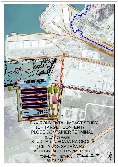
Figure 1. Location <strong>of</strong> planned project 1:50 000<br />
Figure 2.Technological layout – final state 1:2500<br />
Figure 3.Technology – typical cross section 1:500<br />
A.2. DATA FROM PHYSICAL PLANNING DOCUMENT<br />
A.2.1. Strategy and program <strong>of</strong> physical planning <strong>of</strong> the<br />
republic <strong>of</strong> Croatia 2<br />
A.2.2. The Dubrovacko-neretvanska county spatial plan 9<br />
A.2.3. Changes and additions to spatial plan <strong>of</strong><br />
the Kardeljevo municipality to year 2000 15<br />
A.2.4. Changes and additions to master plan<br />
<strong>of</strong> Kardeljevo 19<br />
Attachments:<br />
RIJEKAPROJEKT d.o.o.<br />
1 - 20<br />
Figure 1.Excerpt from the STRATEGY AND PROGRAM OF PHYSICAL PLANNING OF THE REPUBLIC<br />
OF CROATIA<br />
Figure 2. Excerpt from PHYSICAL PLAN OF THE DUBROVACKO- NERETVANSKA COUNTY<br />
Figure 3. Key to Use and Assignment <strong>of</strong> Land<br />
Figure 4. Physical plan <strong>of</strong> Municipality <strong>of</strong> Ploce –Assignment <strong>of</strong> land use in 2000.g.<br />
Figure 5. Master Plan <strong>of</strong> Ploce-Plan assignment <strong>of</strong> land use
ENVIRONMENTAL IMPACT STUDY<br />
Rn: 03-033 CONTAINER TERMINAL PLOCE <strong>PAGE</strong>: 3<br />
A.3. DESCRIPTION OF LOCATION SURROUNDINGS AND<br />
INTERVENTION IMPACT AREA 1 - 63<br />
A.3.1. Location <strong>of</strong> the planned intervention 2<br />
A.3.2. Spatial and functional units and assignment <strong>of</strong><br />
land in the Ploce town area 3<br />
A.3.3. Port industrial complex 6<br />
A.3.4. Analysis <strong>of</strong> natural conditions 9<br />
A.3.5. Assesment <strong>of</strong> the present site capacity 51<br />
Attachments:<br />
Figure 1: Panoramic view <strong>of</strong> the area<br />
Figure 2: Aerial view at the <strong>port</strong> area<br />
Figure 3:View at the <strong>port</strong><br />
Figure 4: Town <strong>port</strong><br />
Figure 5: Development plan for the Port <strong>of</strong> Ploce<br />
Figure 6. Port area - terminals<br />
Figure 7: Wind rose<br />
Figure 8: Wind<br />
Figure 9: Frequency <strong>of</strong> different directions (%) in the climatologic periods 7 a.m., 2 p.m. and 9. p.m. (a)<br />
and total (b).<br />
Figure 10: Mean annual wind force by directions in the climatologic periods 7 a.m, 2 p.m. and 9 p.m. (a)<br />
and total (b) in m/s<br />
Figure 11: Mean annual number <strong>of</strong> days with strong and stormy wind<br />
Figure 12: Annual range <strong>of</strong> the mean wind force<br />
Figure 13: Seasonal and annual frequencies <strong>of</strong> wind force classes (5). The wind force is given in Beaufort.<br />
Figure 14 Mean annual values <strong>of</strong> the sea level height in relation to the mareographic zero in Ploce<br />
in the period from March 2002 - March 2003<br />
Figure 15 Values <strong>of</strong> sea level height in Ploce recorded during occurrence <strong>of</strong> <strong>port</strong> standing waves.<br />
Figure 16 Basic directions <strong>of</strong> surface currents in winter and spring season in the Neretva channel<br />
Scale 1 : 80 000<br />
Figure 17 Permanent surface currents in the zone <strong>of</strong> the Neretva river mouth scale 1 : 40 000<br />
Figure 18 Currents at 5 m depth in the zone <strong>of</strong> the Neretva mouth scale 1 : 40 000<br />
Figure 19 . Mooring place for the Ploce Port<br />
Figure 20 . Wave height for basin between quay 5 and 7<br />
Figure 21. Mean monthly values <strong>of</strong> meteorological elements and occurrences<br />
Figure 22. MEAN DATES OF TEMPERATURE THRESHOLDS AND DURATION OF<br />
TEMPERATURE ABOVE 0°, 5°, 10°, 15° and 20° (in days)<br />
Figure 23 Mean annual air temperature rate, Ploce<br />
Figure 24 Mean annual rate <strong>of</strong> cloud and average number <strong>of</strong> cloudy and clear days<br />
Figure 25 Mean annual rate <strong>of</strong> relative humidity (%) and precipitation (mm)<br />
Figure 26 Annual rate <strong>of</strong> mean and minimum monthly air humidity (%) and average number <strong>of</strong> days<br />
with relative humidity >80% at 14.00 hrs and >30% in all three times <strong>of</strong> measurements<br />
Figure 27 Mean annual rate <strong>of</strong> number <strong>of</strong> days with precipitation and thunder<br />
Figure 28 Mean annual number <strong>of</strong> days with certain quantity <strong>of</strong> precipitation<br />
Figure 29. Planned intervention area in the Ploce Port, view <strong>of</strong> coast<br />
Figure 30. Planned intervention area in the Ploce Port, view <strong>of</strong> sea<br />
Figure 31. Map <strong>of</strong> area with transects PL-01 and PL-02.<br />
Figure 32. Small depth <strong>of</strong> the beginning <strong>of</strong> the transect PL-01.<br />
Figure 33. Transect PL-01 area above sea, buoy marking the end <strong>of</strong> transect.<br />
Figure 34. Short coast <strong>of</strong> sandy silt.<br />
Figure 35: Description <strong>of</strong> the pr<strong>of</strong>ile PL-01<br />
Figure 36. Zoostera noltii sea grass; depth 0,8 m.<br />
Figure 37. Numerous holes in the sediment; depth 0,5 m.<br />
Figure 38. Marine fanworms Sabella spalanzanii; depth 6,8 m.<br />
Figure 39. Terrigenous silt without visible benthonic organisms; depth 9,9 m.<br />
Figure 40. Beginning <strong>of</strong> the transect PL-02.<br />
Figure 41 Transect PL-02.<br />
Figure 42 .End <strong>of</strong> transect PL-02.<br />
Figure 43 .Coastal s<strong>of</strong>t mud<br />
Figure 44. Pr<strong>of</strong>ile <strong>of</strong> the bottom <strong>of</strong> the transect PL-02, with established bottom type and bottom<br />
living communities.<br />
Figure 45. Sandy mud on the beginning <strong>of</strong> the transect, numerous holes visible; depth 2 m.<br />
Figure 46. Terrigenous mud without visible benthonic organisms; depth 13,5 m.<br />
Figure 47. Bare surface abundant with holes and mounts <strong>of</strong> unknown origin; depth 14 m.<br />
Figure. 48. Stations for sediment examination<br />
Figure 49. Results <strong>of</strong> examination <strong>of</strong> sediment in the area <strong>of</strong> the Ploce <strong>port</strong><br />
Figure 50. Characteristics <strong>of</strong> the spatial ambient <strong>of</strong> the Planned Intervention 1:5000<br />
Slika 51. Present state 1:2000<br />
Slika 52. Container terminal - orto foto 1:5000<br />
RIJEKAPROJEKT d.o.o.
ENVIRONMENTAL IMPACT STUDY<br />
Rn: 03-033 CONTAINER TERMINAL PLOCE <strong>PAGE</strong>: 4<br />
A.4. DESCRIPTION OF PROJECT 1-14<br />
A4.1. Function <strong>of</strong> planned project 2<br />
A4.2. Spatial needs <strong>of</strong> planned project 2<br />
A4.3. Construction <strong>of</strong> structure/facility 4<br />
Attachments:<br />
Figure 1. Por <strong>of</strong> Ploce layout plan – functional assembly 1.2000<br />
Figure 2. Purpose <strong>of</strong> area and terms <strong>of</strong> construction 1:2000<br />
Figure 3. Traffic infrastructure 1:2000<br />
Figure 4. Water supply and drainage layout 1:2000<br />
Figure 5. Electrical installation layout - VN and NN distribution 1:2000<br />
A.5. EVALUATION OF COSTS FOR REALIZATION OF<br />
PLANNED INTERVENTION 1-2<br />
A.6. RELATION BETWEEN CONTRACTOR AND<br />
GENERAL PUBLIC 1-2<br />
RIJEKAPROJEKT d.o.o.
ENVIRONMENTAL IMPACT STUDY<br />
Rn: 03-033 CONTAINER TERMINAL PLOCE <strong>PAGE</strong>: 5<br />
B. OPERATION ACCEPTABILITY EVALUATION<br />
B.1. IDENTIFICATION AND OVERVIEW OF POTENTIAL<br />
ENVIRONMENTAL IMPACTS OF THE OPERATION DURING ITS<br />
PREPARATION, CONSTRUCTION AND UTILIZATION PHASE,<br />
INCLUDING ECOLOGICAL DISASTER AND RISK OF ITS<br />
OCCURRENCE 2-4<br />
B.1.1. Overview <strong>of</strong> potential environmental impacts<br />
during the construction phase 3<br />
B.2. OVERVIEW OF POTENTIAL ENVIRONMENTAL IMPACTS<br />
DURING THE UTILIZATION PHASE 1-17<br />
B.2.1. Potential micro-climatic condition change 2<br />
B.2.2. Potential impacts on natural terrestrial and<br />
sea ecosystems 2<br />
B.2.3. Potential changes with regards to utilization 5<br />
B.2.4. Potential changes <strong>of</strong> air or sea water quality,<br />
changes caused by noise, in normal conditions<br />
and in case <strong>of</strong> ecological emergency 6<br />
B.2.5. Potential environmental impacts <strong>of</strong> the operation<br />
in case <strong>of</strong> ecological emergency with occurrence<br />
risk assessment 16<br />
B.3. THE MOST SUITABLE OPTION PROPOSAL<br />
WITH CLARIFICATION 1-3<br />
RIJEKAPROJEKT d.o.o.
ENVIRONMENTAL IMPACT STUDY<br />
Rn: 03-033 CONTAINER TERMINAL PLOCE <strong>PAGE</strong>: 6<br />
C. ENVIRONMENTAL PROTECTIVE MEASURES AND<br />
MEASURE IMPLEMENTATION PLAN<br />
C.1. PROPOSAL OF ENVIRONMENTAL PROTECTIVE MEASURES<br />
DURING THE PHASE OF PREPARATION, CONSTRUCTION AND<br />
EXPLOITATION 1 - 20<br />
C.1.1. Proposed environmental protective<br />
Measures during the phase <strong>of</strong> preparation 3<br />
C.1.2. Proposed environmental protective<br />
Measures during the phase <strong>of</strong> construction 8<br />
C.1.3. Proposed environmental protective<br />
Measures during the phase <strong>of</strong> exploitation 10<br />
Attachments:<br />
Figure 1. Submarine excavation<br />
C.2. PROPOSAL OF MEASURES FOR PREVENTION AND MITIGATION<br />
OF POSSIBLE CONSEQUENCES OF ECOLOGICAL DISASTERS<br />
1 - 2<br />
C.3. ENVIRONMENTAL MONITORING PROGRAM 1 - 3<br />
C.3.1. Sea 2<br />
C.3.2. Traffic Impact 3<br />
C.3.3. Waste 3<br />
Attachments:<br />
Figure 1. Position <strong>of</strong> control measuring points for environemantal state monitoring<br />
C.4. ENVIRONMENT PROTECTION POLICY OF THE INTERVENTION<br />
HOLDER 1 - 3<br />
C.5. PRESENTATION OF THE PLANNED MODE OF COOPERATION OF<br />
INTERVENTION HOLDER WITH THE PUBLIC 1 - 2<br />
RIJEKAPROJEKT d.o.o.
ENVIRONMENTAL IMPACT STUDY<br />
Rn: 03-033 CONTAINER TERMINAL PLOCE <strong>PAGE</strong>: 7<br />
D. STUDY CONCLUSION<br />
D.1. EXPLANATION OF MOST SUITABLE PROJECT<br />
ALTERNATIVE 1-4<br />
D.2. DESCRIPTION OF PROJECT ENVIRONMENTAL IMPACT DURING<br />
PREPARATION, CONSTRUCTION AND USE OF PROJECT,<br />
INCLUDING ALSO ECOLOGICAL INCIDENT AND<br />
RISK OF ITS OCCURRENCE 1-5<br />
D.3. ENVIRONMENTAL PROTECTION MEASURES, DURING<br />
PREPARATION, CONSTRUCTION AND USE OF PROJECT,<br />
INCLUDING ALSO ECOLOGICAL INCIDENT AND RISK<br />
OF ITS OCCURRENCE 1-7<br />
Attachments:<br />
Figure 1. Submarine excavation<br />
D.4. ENVIRONMENTAL STATE MONITORING PROGRAMME 1-3<br />
Attachments:<br />
Figure 1. Position <strong>of</strong> control measuring points for environemantal state monitoring<br />
F. INFORMATION SOURCES 1-6<br />
RIJEKAPROJEKT d.o.o.
ENVIRONMENTAL IMPACT STUDY<br />
Rn: 03-033 CONTAINER TERMINAL PLOCE <strong>PAGE</strong>: 1<br />
A. DESCRIPTION OF INTERVENTION<br />
AND LOCATION<br />
RIJEKAPROJEKT d.o.o.
ENVIRONMENTAL IMPACT STUDY<br />
Rn: 03-033 CONTAINER TERMINAL PLOCE <strong>PAGE</strong>: 2<br />
A.1. PUROSE OF CONSTRUCTION OF CONTAINER<br />
TERMINAL PLOCE<br />
A.1.1. KIND OF INTERVENTION OF IMPORTANCE FOR THE<br />
STATE<br />
A.1.2. REASONS AND OBJECTIVES OF INVESTMENT<br />
CONNECTED TO THE ECONOMIC AND SPATIAL<br />
DEVELOPMENT<br />
A.1.3. BASIC DATA ON THE TECHNOLOGICAL SPECIFICS<br />
OF THE CONTAINER TERMINAL<br />
RIJEKAPROJEKT d.o.o.
ENVIRONMENTAL IMPACT STUDY<br />
Rn: 03-033 CONTAINER TERMINAL PLOCE <strong>PAGE</strong>: 3<br />
A.1. PURPOSE OF UNDERTAKING INTERVENTION<br />
A.1.1. KIND OF INTERVENTION OF IMPORTANCE FOR THE STATE<br />
Today, the Port <strong>of</strong> Ploce is a <strong>port</strong> <strong>of</strong> state significance open to home and<br />
international public traffic, and mainly designated for cargo traffic.<br />
The Dubrovacko-neretvanska County Spatial Plan defined that the Port<br />
<strong>of</strong> Ploce is a <strong>port</strong> <strong>of</strong> special (international) economic interest for the<br />
Republic <strong>of</strong> Croatia.<br />
LAW REGULATIONS<br />
In accordance with the Law on maritime estate and sea <strong>port</strong>s (Official<br />
Gazette158/03), a <strong>port</strong> is defined as a sea <strong>port</strong>, i.e. marine and land space<br />
directly connected with the sea with wharves and non built shores,<br />
breakwaters, equipment, plants and other structures designated for landing,<br />
anchoring and protection <strong>of</strong> ships, yachts and boats, loading and unloading <strong>of</strong><br />
passengers and goods, storage and other handling <strong>of</strong> goods, production,<br />
enrichment and finishing <strong>of</strong> goods and other economic activities, which are in<br />
economic, traffic or technological interrelation with these activities.<br />
Port area <strong>of</strong> a <strong>port</strong> is the sea <strong>port</strong> area consisting <strong>of</strong> one or more sea and land<br />
spaces (<strong>port</strong> basin) used for <strong>port</strong> activities operations and under<br />
administration <strong>of</strong> a <strong>port</strong> <strong>authority</strong>, i.e. concessionaire representative, and the<br />
<strong>port</strong> area boundary-line are the boundary <strong>of</strong> the maritime estate.<br />
According to the purpose they are used for, <strong>port</strong>s are divided to:<br />
- <strong>port</strong>s open to public traffic<br />
- <strong>port</strong>s for special designation<br />
Port open to public traffic is a sea <strong>port</strong> which, under equal terms, can be<br />
used by every physical and legal entity in accordance with its designation and<br />
within the limits <strong>of</strong> available capacities.<br />
Ports open for public traffic can be: <strong>port</strong>s open to international traffic and <strong>port</strong>s<br />
open to home traffic, in accordance with the Maritime Code.<br />
The <strong>port</strong> can consist <strong>of</strong> one or more basins.<br />
According to size and significance for the Republic <strong>of</strong> Croatia, the <strong>port</strong>s open<br />
to public traffic are divided to:<br />
• Ports <strong>of</strong> special (international) economic interest for the Republic <strong>of</strong><br />
Croatia<br />
• Ports <strong>of</strong> county significance<br />
• Port <strong>of</strong> local significance<br />
RIJEKAPROJEKT d.o.o.
ENVIRONMENTAL IMPACT STUDY<br />
Rn: 03-033 CONTAINER TERMINAL PLOCE <strong>PAGE</strong>: 4<br />
In accordance with “Ordinance on the criteria for ranking <strong>of</strong> <strong>port</strong>s open to<br />
public traffic” (NN 31/96) the criteria for classification <strong>of</strong> <strong>port</strong>s open to public<br />
traffic under <strong>port</strong>s <strong>of</strong> special (international) economic interest for the Republic<br />
<strong>of</strong> Croatia are:<br />
• average traffic exceeding 3,000,000 tons <strong>of</strong> cargo per year, with 10%<br />
share <strong>of</strong> transit traffic in the structure <strong>of</strong> the total traffic between 1985<br />
and 1990, or average traffic <strong>of</strong> passengers exceeding 500,000<br />
passengers per year with 10% <strong>of</strong> passengers in international traffic<br />
between 1985 and 1990 for a <strong>port</strong> operating for passenger traffic only;<br />
• railway and road connections with inland, i.e. connection to air<strong>port</strong>s;<br />
• installed <strong>port</strong> capacities for traffic <strong>of</strong> 5,000,000 tons <strong>of</strong> cargo per year<br />
in accordance with the cargo structure against main goods groups, and<br />
developed shoreline and piers for anchorage <strong>of</strong> ships length over 130<br />
m and draught 6 m.<br />
• no less than five regular ship lines per month or minimum three<br />
international lines per year for <strong>port</strong> operating for passenger traffic only.<br />
In accordance with “Ordinance on ranking <strong>of</strong> the Port <strong>of</strong> Ploce” (Official<br />
Gazette no. 37/96):<br />
• According to size and significance the Port <strong>of</strong> Ploce has been<br />
ranked under a <strong>port</strong> <strong>of</strong> special (international) economic<br />
im<strong>port</strong>ance for the Republic <strong>of</strong> Croatia.<br />
• Port <strong>of</strong> Ploce is a <strong>port</strong> open to international public traffic.<br />
RIJEKAPROJEKT d.o.o.
ENVIRONMENTAL IMPACT STUDY<br />
Rn: 03-033 CONTAINER TERMINAL PLOCE <strong>PAGE</strong>: 5<br />
A.1.2. REASONS AND OBJECTIVES OF INVESTMENT CONNECTED TO<br />
ECONOMIC AND SPATIAL DEVELOPMENT<br />
In 2002 the Port <strong>of</strong> Ploce reloaded about 10.000 TEU. There is a regular<br />
weekly feeder line to the <strong>port</strong>s <strong>of</strong> Malta and Gioia Tauto in Italy. The shipping<br />
company is Lošinjska plovidba - brodarstvo d.d. The ship UPA can trans<strong>port</strong><br />
226 TEU. This year an additional ship RAPOCA <strong>of</strong> the same shipping<br />
company has been introduced to the same line twice a week.<br />
With the aim to obtain a thorough insight, as well as scientific and expert<br />
assessment <strong>of</strong> the possibilities and needs <strong>of</strong> sea <strong>port</strong>s several scientific<br />
institutions and foreign companies have been engaged, which have also<br />
prepared the development studies for the Port <strong>of</strong> Ploce, and in which the<br />
segment <strong>of</strong> the <strong>port</strong> containerization has also been considered:<br />
• Economic and technical study <strong>of</strong> the <strong>port</strong>s <strong>of</strong> Rijeka and Ploce,<br />
S<strong>of</strong>remer - Apis, 1997. (financed by the Works Bank);<br />
• Study on the multimodal traffic corridor Ploce-Sarajevo (financed by<br />
TDA, USA Government Agency),<br />
• Forecast <strong>of</strong> traffic <strong>of</strong> these goods has been given also by the one and<br />
only operator in the <strong>port</strong> area – the Port <strong>of</strong> Ploce.<br />
The first study was used as landmark document for elaboration <strong>of</strong> the Traffic<br />
Development Strategy <strong>of</strong> the Republic <strong>of</strong> Croatia, which related to <strong>port</strong>s, and a<br />
Sea Ports Development Plan for the period <strong>of</strong> 10 years has been prepared but<br />
not yet passed. The quantities <strong>of</strong> containers to be trans<strong>port</strong>ed through the Port<br />
<strong>of</strong> Ploce according to this plan should be:<br />
YEAR 1989 1995 1999 2000 2005 2010<br />
TEU 2,500 250 1,800 3,000 32,000 71,000<br />
The decision to initiate preparations for this investment has been influenced<br />
by the planned traffic forecasts and by the fact that the existing container<br />
traffic handling is even now a problem for the Port <strong>of</strong> Ploce.<br />
There are no onshore surfaces for container storage, the surfaces have not<br />
been designed to withstand heavy loads <strong>of</strong> the equipment required for such<br />
handling, the bearing capacity <strong>of</strong> operative shoreline for installation <strong>of</strong> special<br />
equipment for container transshipment are questionable and re<strong>port</strong>ed several<br />
times already. To conclude with, the Port <strong>of</strong> Ploce does not possess<br />
equipment suitable for reloading <strong>of</strong> container unit by LO-LO technology.<br />
On the basis <strong>of</strong> all these reasons, a clear goal was set out:<br />
The Port <strong>of</strong> Ploce should be equipped for container traffic by construction <strong>of</strong> a<br />
container terminal, capacity 100 000 TEU per year.<br />
RIJEKAPROJEKT d.o.o.
ENVIRONMENTAL IMPACT STUDY<br />
Rn: 03-033 CONTAINER TERMINAL PLOCE <strong>PAGE</strong>: 6<br />
A.1.3 BASIC DATA ON TECHNOLOGICAL SPECIFICS<br />
A.1.3.1. EXISTING STATUS ON THE LOCATION<br />
Micro location <strong>of</strong> the container terminal has been proposed based on the<br />
analysis <strong>of</strong> the local geography, suitable access from the sea and protected<br />
basin docks 5 and 7 against adverse meteorological, hydrographical effects,<br />
suitable access from inland-road/railway, adjacent required municipal<br />
infrastructure, enough space for extension <strong>of</strong> the terminal. Since impact on<br />
environment is not significant, the location is a buffer-zone against the city<br />
between the existing built volumes and pollutants which will be farther on. The<br />
bulk cargo terminals located opposite <strong>of</strong> the dock no.5.To the North is limited<br />
by the future waterline – dock 7, to the East by the existing runaway <strong>of</strong> the<br />
Air<strong>port</strong> Ploce, which is located in the area <strong>of</strong> the Neretva river valley, and in<br />
accordance with the Dubrovacko-Neretvanska County Spatial Plan, to the<br />
South by the future railway tracks routs and to the West by the shore line. The<br />
surface <strong>of</strong> this land plot is about 210.000 m². For half <strong>of</strong> this surface on which<br />
the container terminal will be built the Location Permit will be obtained. The<br />
remaining surface will be kept for expansion <strong>of</strong> the terminal what we do not<br />
foresee to be in so near future.<br />
A.1.3.2. DESCRIPTION OF INTERVENTION ON SHORES AND STORAGE SPACE<br />
Warf length 260 m is to form the line <strong>of</strong> the future dock 7 with water landing<br />
area depth <strong>of</strong> 13.5 m, in which root the RO-RO ramp is to be built. In the<br />
reloading zone the equipment is to be placed with technical characteristics<br />
enabling transshipment <strong>of</strong> the container ships <strong>of</strong> the third generation. The<br />
surface provided for construction <strong>of</strong> terminal is to be about 100,000 m². It is<br />
provided to include the zone for reloading ships and railway cars, the zone for<br />
storage, service zone and surfaces needed for the main infrastructure (roads,<br />
power supply , telecommunications), and is to include RO-RO space also.<br />
The design provides also construction <strong>of</strong> all infrastructure structures/facilities<br />
outside the terminal land plot necessary for its operation as one technological<br />
unit.<br />
The Location Permit has been applied for the final construction stage which<br />
includes RO-RO ramp also, and construction in phase should be made<br />
possible.<br />
RAILWAY TRACKS<br />
In order to get an insight into the status <strong>of</strong> railway infrastructure in the Port <strong>of</strong><br />
Ploce as well as the marshalling tracks in the cargo railway station adjacent to<br />
the Port <strong>of</strong> Ploce, used as sup<strong>port</strong>ing structure to the <strong>port</strong> capacities, in 1988<br />
a Study on track capacities in the Port <strong>of</strong> Ploce and railway station Ploce<br />
(Institute for Traffic, Sarajevo, November 1988) was prepared. The conclusion<br />
<strong>of</strong> this study was that at construction <strong>of</strong> new railway capacities it will be<br />
necessary to undertake reconstruction <strong>of</strong> the connection <strong>of</strong> the existing <strong>port</strong><br />
capacities to the cargo station Ploce.<br />
As shown in this study at construction <strong>of</strong> the container terminal it is necessary,<br />
besides the railway tracks on the terminal itself, construct marshalling groups<br />
III and IV. The first mentioned for the needs <strong>of</strong> the timber transit terminal and<br />
waterfront tracks <strong>of</strong> the future container terminal, and the second for the<br />
RIJEKAPROJEKT d.o.o.
ENVIRONMENTAL IMPACT STUDY<br />
Rn: 03-033 CONTAINER TERMINAL PLOCE <strong>PAGE</strong>: 7<br />
needs <strong>of</strong> the mainly container terminal. In addition, it is necessary to<br />
undertake reconstruction <strong>of</strong> the existing connection and connection <strong>of</strong> the<br />
connection track to the cargo station Ploce (about 600 m).<br />
ROADS<br />
The Spatial Plan <strong>of</strong> the Port <strong>of</strong> Ploce has provided for construction <strong>of</strong> the main<br />
<strong>port</strong> road 15.0 m wide, which goes to the main gate <strong>of</strong> the container terminal.<br />
For the main <strong>port</strong> road the Main Design has been prepared. So far about 350<br />
m <strong>of</strong> mentioned road has been built, while for the remaining about 580 m<br />
earth works are carried out. The Consultant will renew this documentation and<br />
design the road connections <strong>of</strong> this road to the traffic infrastructure <strong>of</strong> the<br />
container terminal.<br />
POWER SUPPLY SYSTEM<br />
Feeding <strong>of</strong> the Port <strong>of</strong> Ploce is from 10kV network from TS 35/10 kV Vranjak,<br />
which is located adjacent to the <strong>port</strong> fence. The energy is supplied through<br />
two cable lines type PP 41 A 3 x 150 mm² to switching yard 10 (20) kV <strong>of</strong> the<br />
Port <strong>of</strong> Ploce an from there to separate transformer substations within the <strong>port</strong><br />
area.<br />
For the future container terminal there is a 10 kV cable, which route goes<br />
along the edge <strong>of</strong> the future terminal. Although this cable is in function and<br />
can serve for supply <strong>of</strong> the future terminal, it is obsolete and in future could be<br />
unsafe for the good quality feeding. Therefore, being aware <strong>of</strong> the need <strong>of</strong> the<br />
future <strong>port</strong> capacities for electric energy and water, the Port Authority has<br />
order elaboration <strong>of</strong> Main Design, Construction <strong>of</strong> public utilities system along<br />
the main <strong>port</strong> road with connection <strong>of</strong> the power supply cable Switch yard - TS<br />
Vranjak. The goal <strong>of</strong> this design is sizing and construction <strong>of</strong> an infrastructure<br />
corridor by which this new part <strong>of</strong> the <strong>port</strong> will be supplied with the necessary<br />
quantities <strong>of</strong> water and electric energy and creating a ring <strong>of</strong> 10 kV lines within<br />
the Port <strong>of</strong> Ploce space. The public utilities system is to be built along the<br />
main <strong>port</strong> road to South, and all utilities are provided to be placed into a<br />
reinforced concrete channel.<br />
The connection <strong>of</strong> the container terminal to new cable 10/20 kV cable is to be<br />
also at the edge <strong>of</strong> the container terminal. In this case the existing cable 10 kV<br />
network is provided as reserve to the new network.<br />
TELEPHONE AND FIRE ALARM<br />
The existing primary telephone and fire alarm networks within the <strong>port</strong> area<br />
have been reconstructed in the eastern part <strong>of</strong> the <strong>port</strong>. The ducts, cable<br />
manholes, new cable switch boards were installed, PEHD pipes laid, fire<br />
alarm cables, type JB- Y(ST)Y and telephone cables, type TK 59 were pulled<br />
through, with capacity to satisfy the existing and future needs. The<br />
reconstruction <strong>of</strong> the western part <strong>of</strong> the <strong>port</strong> is planned and will be completed<br />
during 2004.<br />
From the telephone, i.e. fire alarm stations, there is a built cable duct network<br />
leading to the HPT post <strong>of</strong>fice in which the PEHD pipes have been laid.<br />
RIJEKAPROJEKT d.o.o.
ENVIRONMENTAL IMPACT STUDY<br />
Rn: 03-033 CONTAINER TERMINAL PLOCE <strong>PAGE</strong>: 8<br />
For the needs <strong>of</strong> the container terminal in the part <strong>of</strong> telephone and fire alarm<br />
system and connection to the main fire alarm station, i.e. telephone station, it<br />
will be necessary to build a cable ducts network from the cable manhole KZ<br />
1.1 in the direction <strong>of</strong> the future container terminal space.<br />
WATER SUPPLY SYSTEM<br />
The main feeding <strong>port</strong> water supply system is built <strong>of</strong> steel pipes Ø 200 mm<br />
and laid underground, along the eastern edge <strong>of</strong> the road in the direction <strong>of</strong><br />
«Energopetrol» and passes along the edge <strong>of</strong> the future container terminal. Its<br />
capacity is 33.6 l/s, and pressure 5.5-6.0 bar.<br />
RIJEKAPROJEKT d.o.o.
A1. PURPOSE OF PROJECT<br />
CONSTRUCTION UNDERTAKING<br />
LOCATION OF PLANNED PROJECT<br />
A1. SVRHA PODUZIMANJA<br />
IZGRADNJE ZAHVATA<br />
LOKACIJA PLANIRANOG ZAHVATA<br />
PROJECT SCALE (MJ) 1:50000<br />
KEY (LEGENDA):<br />
PROJECT BOUNDARY (GRANICA ZAHVATA )<br />
PORT AREA (LUCKO PODRUCJE)
60 000 DWT<br />
50 000 DWT<br />
l=290,0m<br />
b=32,40m<br />
d=13,0m<br />
OBALA 7<br />
OBALA 5<br />
m o r e<br />
30 000 DWT<br />
l=228,0m<br />
b=31,0m<br />
d=11,30m<br />
30 000 DWT<br />
14 000 DWT<br />
l=145,0m<br />
b=20,0m<br />
d=8,5m<br />
11 000 DWT<br />
l=135,0m<br />
b=18,0m<br />
d=8,0m<br />
OBALA 6<br />
TS-15<br />
interspeds−stocarnik<br />
intersped−stocarnik<br />
gps<br />
z<br />
vatrogasci<br />
z<br />
z<br />
z<br />
2179/2<br />
(4559/80)<br />
z<br />
z<br />
garaza<br />
ts<br />
I<br />
z<br />
z<br />
poslovni prostor − terminal za drvo<br />
z<br />
z z<br />
z<br />
ts<br />
RANŽIRNA GRUPA 3-PROJEKTIRANO<br />
RANŽIRNA GRUPA 2-IZVEDENO<br />
A1. PURPOSE OF PROJECT CONSTRUCTION<br />
UNDERTAKING<br />
RANŽIRNA GRUPA 1-IZVEDENO<br />
TECHNOLOGICAL LAYOUT - FINAL STATE<br />
A1. SVRHA PODUZIMANJA I IZGRADNJE ZAHVATA<br />
SITUACIJA TEHNOLOGIJE - KONACNO STANJE<br />
SCALE (MJ) 1:2500<br />
KEY (LEGENDA):<br />
PROJECT BOUNDARY (GRANICA ZAHVATA)<br />
LINE OF EXISTING WATERFRONT (LINIJA POSTOJECE OBALE)<br />
LINE OF NEW WATERFRONT (LINIJA NOVE OBALE)<br />
EXISTING RAILWAYS (POSTOJECE ŽELJEZNICE)<br />
DESIGNED RAILWAYS (PROJEKTIRANE ŽELJEZNICE)<br />
EXISTING ROADS (POSTOJECE CESTE)<br />
DESIGNED ROADS (PROJEKTIRANE CESTE)<br />
FENCE (OGRADA)<br />
EXISTING STRUCTURES (POSTOJECI OBJEKTI)<br />
SEA (MORE)<br />
STORAGE AREAS (POVRŠINE ZA SKLADIŠTA)<br />
CONTAINER DISPOSAL AREAS (POVRŠINE ZA ODLAGANJE KONTEJNERA)<br />
GREEN AREAS (ZELENE POVRŠINE)<br />
GROUND (TEREN)<br />
STRUCTURES (OBJEKTI)<br />
SL. 2
A1. PURPOSE OF PROJECT CONSTRUCTION<br />
UNDERTAKING<br />
TECHNOLOGY - TYPICAL CROSS<br />
A1. SVRHA PODUZIMANJA I IZGRADNJE ZAHVATA<br />
TEHNOLOGIJA-KARAKTERISTOCNI POPRECNI<br />
PRESJECI<br />
SECTIONS SCALE (MJ) 1:500<br />
SL. 3
ENVIRONMENTAL IMPACT STUDY<br />
Rn: 03-033 CONTAINER TERMINAL PLOCE <strong>PAGE</strong>: 1<br />
A.2. DATA FROM PHYSICAL PLANNING DOCUMENT<br />
A.2.1. STRATEGY AND PROGRAMME OF PHYSICAL PLANNING OF THE<br />
REPUBLIC OF CROATIA<br />
A.2.2. THE DUBROVACKO-NERETVANSKA COUNTY SPATIAL PLAN<br />
A.2.3. CHANGES AND ADDITIONS TO SPATIAL PLAN OF THE<br />
KARDELJEVO MUNICIPALITY TO YEAR 2000<br />
A.2.4. CHAGES AND ADDITIONS TO MASTER PLAN OF KARDELJEVO<br />
RIJEKAPROJEKT d.o.o.
ENVIRONMENTAL IMPACT STUDY<br />
Rn: 03-033 CONTAINER TERMINAL PLOCE <strong>PAGE</strong>: 2<br />
For the intended intervention and analyzed space, considering the<br />
international im<strong>port</strong>ance <strong>of</strong> the <strong>port</strong>, all currently valid physical planning<br />
documents <strong>of</strong> this area have been analyzed, as well as those that will be<br />
passed in near future.<br />
They are:<br />
• STRATEGY AND PROGRAMME OF PHYSICAL PLANNING OF THE<br />
REPUBLIC OF CROATIA<br />
• DUBROVACKO-NERETVANSKA COUNTY SPATIAL PLAN<br />
• CHANGES AND ADDITIONS TO SPATIAL PLAN OF MUNICIPALITY<br />
OF KARDELJEVO UNTIL YEAR 2000<br />
• CHANGES AND ADDITIONS TO MASTER PLAN OF KARDELJEVO<br />
A.2.1. STRATEGY AND PROGRAMME OF PHYSICAL PLANNING OF THE<br />
REPUBLIC OF CROATIA<br />
(Ministry <strong>of</strong> Physical Planning, Construction and Housing, Institute for<br />
Spatial Planning, 1999, Official Gazette no. 50/99)<br />
The physical planning strategy <strong>of</strong> the Republic <strong>of</strong> Croatia has ranked the Port<br />
<strong>of</strong> Ploce among the seven biggest sea <strong>port</strong>s on the Croatian coast.<br />
The Strategy has defined the spatial development and planning trends and<br />
main development terms <strong>of</strong> reference for infrastructure systems. For the<br />
maritime traffic, as part <strong>of</strong> the infrastructure, i.e. traffic system, we can read<br />
the following assessment <strong>of</strong> the present status (section 4.4.1.2., page 115.):<br />
«The specific <strong>of</strong> the Croatian spatial territory is the very long and well indented<br />
coast that throughout history has been the natural base for development <strong>of</strong><br />
<strong>port</strong>s in many places what was acceptable at that time considering the level <strong>of</strong><br />
technique and technology. During the last fifty years due to the world<br />
economy development trends a phenomenon has arisen that some <strong>port</strong>s have<br />
been promoted into carriers <strong>of</strong> connection. In result <strong>of</strong> such policy seven big<br />
<strong>port</strong>s have been built on the Croatian coast (Rijeka, Pula, Zadar, Šibenik,<br />
Split, Ploce and Dubrovnik), with length <strong>of</strong> built operative shores 17,736 m,<br />
covering space about 700 ha, and reloaded cargo volume 14,891.000 tons for<br />
1995. This is a considerate decrease in comparison to traffic volumes before<br />
the Homeland War. Before the Homeland War began the operative shores<br />
built volumes and the superstructure was satisfactory with positive<br />
development trends».<br />
In the section Spatial-development and planning directives we can read<br />
the following guidelines (section 4.4.1.4., page 120.):<br />
«Revitalization <strong>of</strong> the maritime traffic in Croatia, considering the well indented<br />
coast and its length, is a necessity for Croatia and the neighboring countries<br />
both on home and international level. The further development <strong>of</strong> <strong>port</strong>s and<br />
marine connections should be based on the needs <strong>of</strong> the state (meaning<br />
connections with other countries), and at home level on needs <strong>of</strong> particular<br />
regions, especially islands, and economic activities <strong>of</strong> the country (ecological<br />
sustainable economy).<br />
RIJEKAPROJEKT d.o.o.
ENVIRONMENTAL IMPACT STUDY<br />
Rn: 03-033 CONTAINER TERMINAL PLOCE <strong>PAGE</strong>: 3<br />
The modern technology in trans<strong>port</strong>ation, transshipment and <strong>port</strong> handling is<br />
developing in such direction that <strong>port</strong>s become more and more specialized for<br />
specific designations and specific kinds <strong>of</strong> cargos. The first degree <strong>of</strong><br />
specialization begins with unitized cargo from <strong>port</strong> to <strong>port</strong> and ends with<br />
automatic monitoring <strong>of</strong> cargo from the consigner to the consignee with all<br />
activities and changes <strong>of</strong> traffic branches. In this segment the Croatian <strong>port</strong>s,<br />
as well as the whole Croatian traffic system, are not at all at an enviable level<br />
and would require urgent and overall modernization in accordance with<br />
available resources, which would rendered them equipped to respond to<br />
possibilities that are generally known and applied in the developed world.<br />
The Port <strong>of</strong> Ploce should predominately develop for the needs <strong>of</strong> the<br />
neighboring Bosnia and Herzegovina, but also for broader home and<br />
international hinterland.<br />
GOALS AND TRENDS OF MARITIME TRAFFIC DEVELOPMENT:<br />
• revalorization the traffic value <strong>of</strong> the Adriatic Sea and proper evaluation<br />
<strong>of</strong> the exceptional geo-traffic advantages <strong>of</strong> the Adriatic traffic route,<br />
which would open the Croatian spatial territory to main traffic flows<br />
thus improving the Croatian costal and ferry navigation,<br />
• reorganization and upgrading <strong>of</strong> the Croatian <strong>port</strong>s technology base,<br />
providing better links with the world/inland and continent and promote<br />
use <strong>of</strong> the Croatian <strong>port</strong>s for realization <strong>of</strong> different economic activities<br />
thus attracting, as much as possible, traffic flows (goods) from Eastern<br />
Europe (in all Croatian <strong>port</strong>s, and in particular to Rijeka and Ploce.<br />
Request for new space is relevant for three <strong>port</strong>s only: Rijeka, Split<br />
and Ploce,<br />
• improvement <strong>of</strong> following new techniques and technologies in maritime<br />
traffic (application <strong>of</strong> containers, unitized cargo, and other).<br />
Considering the above, validate and incorporate into the spatial plans <strong>of</strong><br />
lower-rank the requirements and conditions relating to space for the requested<br />
extensions and modernization. It is equally im<strong>port</strong>ant that the planning <strong>of</strong> <strong>port</strong>s<br />
at local level is harmonized with the General Development Plans <strong>of</strong> the costal<br />
region/islands.<br />
This physical planning document has defined that in reconstructions or<br />
constructions <strong>of</strong> new structures the highest technological, economic and<br />
ecological criteria should be applied, and emphasized that physical planning<br />
<strong>of</strong> the maritime traffic must be prepared in compliance with regulations <strong>of</strong><br />
relevant laws, in particular those regulating <strong>port</strong>s as part <strong>of</strong> the maritime<br />
estate.<br />
RIJEKAPROJEKT d.o.o.
ENVIRONMENTAL IMPACT STUDY<br />
Rn: 03-033 CONTAINER TERMINAL PLOCE <strong>PAGE</strong>: 4<br />
In the «Programme <strong>of</strong> Physical Planning <strong>of</strong> the Republic <strong>of</strong> Croatia» we<br />
can read in section 3.1.3. Martine traffic goals and guidelines for<br />
development <strong>of</strong> the maritime traffic:<br />
(3-6)<br />
(3-7)<br />
In the new circumstances <strong>of</strong> social and economic development in<br />
Croatia, the development <strong>of</strong> the maritime traffic should be based on<br />
the advantages <strong>of</strong> Croatia, with particular emphasis on improvement <strong>of</strong><br />
connections between islands, and systematic approach in the following<br />
segments:<br />
Physical planning <strong>of</strong> <strong>port</strong>s should be planned at the level <strong>of</strong> needs <strong>of</strong><br />
the economy and traffic as a whole, and establish the spatial<br />
requirements for necessary extensions and modernization.<br />
The maritime traffic physical planning should comply with all<br />
regulations <strong>of</strong> relevant laws, and in particular those regulating <strong>port</strong>s as<br />
part <strong>of</strong> the maritime estate. At reconstruction or construction <strong>of</strong> new<br />
projects/structures, all interventions should be undertaken in<br />
compliance with the highest technological, economic and ecological<br />
criteria, and include investigation <strong>of</strong> the interrelations <strong>of</strong> traffic corridors<br />
road-railway-sea in the narrow costal space/islands.<br />
Priorities in elaboration <strong>of</strong> documents are:<br />
• strategic development plan <strong>of</strong> all <strong>port</strong>s<br />
• general development plan <strong>of</strong> the <strong>port</strong> systems <strong>of</strong> Rijeka and<br />
Ploce<br />
The connection <strong>of</strong> <strong>port</strong>s with the inland traffic structure should be<br />
improved.<br />
While developing the broader maritime infrastructure priority should be given<br />
to improvement <strong>of</strong> technical and technological characteristics <strong>of</strong> marine<br />
vessels and accompanying <strong>port</strong> services.<br />
In the section 4.4. Maritime estate we can read:<br />
In further development Croatia should adopt a more appropriate and<br />
systematic approach when using the advantages <strong>of</strong> its position on the<br />
Mediterranean with distinctive orientation to tourism and maritime economy.<br />
(4-13)<br />
Improvement <strong>of</strong> the maritime orientation <strong>of</strong> the country should be<br />
based in particular on:<br />
• maritime traffic and shipping industry,<br />
• <strong>port</strong> economy (including joint economic activities and free<br />
zones) …<br />
RIJEKAPROJEKT d.o.o.
ENVIRONMENTAL IMPACT STUDY<br />
Rn: 03-033 CONTAINER TERMINAL PLOCE <strong>PAGE</strong>: 5<br />
The economic interests and programmes should be prepared in such<br />
way to incorporate broader influences and especially those related to<br />
development <strong>of</strong> costal settlements in relation to lithologization<br />
processes and influences <strong>of</strong> other activities, and include environmental<br />
impacts as well as account for the fact that good quality environment is<br />
considered as the main advantage and specifics <strong>of</strong> the Croatian<br />
maritime economy.<br />
This objective can be achieved through systematic determination <strong>of</strong><br />
the maritime estate boundaries, allowable maritime space pressures<br />
(land and home waters), and criteria for location <strong>of</strong> economic activities.<br />
Special im<strong>port</strong>ance should be given to valorization and preservation <strong>of</strong><br />
sea water quality and the costal region on a larger scale.<br />
In the section 5.1. Environmental protection, among other things, we read:<br />
(5-1)<br />
(5-2)<br />
(5-3)<br />
Croatia should improve the present quality <strong>of</strong> the environment, and in<br />
further development remove causes <strong>of</strong> pollution and make efforts to<br />
coordinate future development with the efforts to achieve better quality<br />
<strong>of</strong> living. It is <strong>of</strong> special im<strong>port</strong>ance that the environmental protection is<br />
implemented per sectors- departments based on laws and regulations<br />
and in accordance with the Strategy on Environmental Protection,<br />
systematic preventive measures against adverse impacts and<br />
incentive procedures aimed at preservation and improvement <strong>of</strong> the<br />
environment.<br />
Croatia will enforce the signed bilateral agreements and conventions at<br />
all levels, especially those on sustainable development, biological<br />
diversity and human settlements, and in the framework <strong>of</strong><br />
management <strong>of</strong> the larger spatial units belonging to the European<br />
systems (Adriatic Sea, Danube basin) and implement a system <strong>of</strong><br />
protection <strong>of</strong> generally recognized values.<br />
Due to specifics <strong>of</strong> the Croatian spatial territory and past development<br />
trends the following aspects should be emphasized:<br />
• on the global level it is im<strong>port</strong>ant to establish an integral<br />
approach to management <strong>of</strong> larger units, and special<br />
emphasize should be given, among other things, to the Adriatic<br />
Sea.<br />
Application <strong>of</strong> the environmental protection principles in spatial<br />
planning is based on modern principles and standards <strong>of</strong> the<br />
environmental protection and the quality <strong>of</strong> the environment should be<br />
the main criterion in spatial planning.<br />
RIJEKAPROJEKT d.o.o.
ENVIRONMENTAL IMPACT STUDY<br />
Rn: 03-033 CONTAINER TERMINAL PLOCE <strong>PAGE</strong>: 6<br />
(5-4)<br />
More efficient spatial planning would require proper clarification <strong>of</strong><br />
the actual circumstances:<br />
• spatial pressures and past hazards, or the degree <strong>of</strong> the<br />
preserved quality <strong>of</strong> specific space and acceptable<br />
(sustainable) spatial capacity,<br />
• status, drawbacks and requirements relating needs in technical<br />
infrastructure,<br />
• natural and created values to be protected by application <strong>of</strong><br />
special categories <strong>of</strong> protection as well as physical planning<br />
measures in connection with use <strong>of</strong> space,<br />
• regulations, agreements and conventions applying to specific<br />
area and determined kind <strong>of</strong> space -resource.<br />
The development context is marked by circumstances present in the<br />
body <strong>of</strong> undergoing social changes, by old technologies, incomplete<br />
physical planning systems and unbalanced development, aspirations<br />
for fast development, therefore special attention should be paid when<br />
choosing development programs; obsolete and hazardous<br />
technologies that represent a treat to space should be disregarded, as<br />
well as irrational exploitation <strong>of</strong> resources and space that can bring<br />
short term benefits, but in the long run can cause damage to space<br />
and environment, should not be allowed.<br />
Therefore it is necessary to:<br />
• enforce measures for remediation <strong>of</strong> endangered parts <strong>of</strong><br />
space and environment within the framework <strong>of</strong> departments<br />
activities and engagement <strong>of</strong> all entities involved in space use,<br />
in particular those systems causing considerable environmental<br />
loads, like industry and mining, energetic industry, traffic,<br />
intensive farming, water management,<br />
• investigate and correct the former spatial-planning and<br />
development projections, considering mainly declamatory<br />
postulations <strong>of</strong> environmental protection, unbalanced and<br />
unreal past development trends <strong>of</strong> all development indexes,<br />
with side effects <strong>of</strong> adverse space loads, and define criteria for<br />
space use in accordance with guidelines <strong>of</strong> sustainable and<br />
balanced development that will account for the specifics and<br />
sensitiveness (vulnerability) <strong>of</strong> the spatial structure,<br />
• increase investments in infrastructure and qualitative changes<br />
<strong>of</strong> the existing economy systems (removal <strong>of</strong> unclean and<br />
obsolete technologies), and when defining new locations and<br />
routs consider all key elements <strong>of</strong> environment and space<br />
through application <strong>of</strong> an interdisciplinary approach,<br />
• establish mechanisms <strong>of</strong> information and decision making<br />
based on reliability and verification <strong>of</strong> data, and promote cooperation<br />
and consensus <strong>of</strong> all relevant entities and local<br />
communities,<br />
• prevent possible and actual pollutions in-situ (in the framework<br />
<strong>of</strong> technologies and functional units), establish economic and<br />
legal instruments <strong>of</strong> incentives and penalties and recognize<br />
RIJEKAPROJEKT d.o.o.
ENVIRONMENTAL IMPACT STUDY<br />
Rn: 03-033 CONTAINER TERMINAL PLOCE <strong>PAGE</strong>: 7<br />
(5-5)<br />
conflicts and solve them primarily through prevention and<br />
incentive measures.<br />
During elaboration and implementation <strong>of</strong> the Strategy guidelines and<br />
department programmes at the level <strong>of</strong> significant interventions<br />
(national programmes, programmes <strong>of</strong> complex infrastructureeconomy<br />
systems and other), environmental protection must be<br />
considered as the basic principle and goal to be realized through<br />
application <strong>of</strong> systematic measures at both state and local levels.<br />
Key action fields are the areas <strong>of</strong> economy concentration, exploitation<br />
<strong>of</strong> natural resources, and conflict <strong>of</strong> interests in use <strong>of</strong> urban space,<br />
especially in cities, with priorities:<br />
Energetic and industry: priority in updating and introduction <strong>of</strong><br />
modern technologies that will lower and even eliminate the adverse<br />
trends, and in further development, care in selection <strong>of</strong> locations and<br />
technologies, and implementation <strong>of</strong> all measures already in the<br />
preliminary phase <strong>of</strong> planning to secure best possible location and<br />
operation within the allowable environmental pressures.<br />
Infrastructure and municipal activities: modernization <strong>of</strong><br />
infrastructure networks - solution <strong>of</strong> traffic problems in cities and other.<br />
Landscape: implementation <strong>of</strong> protection measures <strong>of</strong> natural and<br />
cultural heritage and preservation <strong>of</strong> the cultural and natural features <strong>of</strong><br />
landscape as a whole.<br />
At the state and local levels it is necessary to establish such<br />
instruments <strong>of</strong> taxation policy and financial measures that will treat the<br />
ecological component as an expenditure item, but payment should not<br />
give right to pollution.<br />
At the local level as well as within framework <strong>of</strong> competences <strong>of</strong> the<br />
environmental management entities, it is necessary to implement<br />
urgent and pragmatic measures that do not require complex<br />
procedures and projects or major funds, but are relating to behavior<br />
and order in space and concern organization and function <strong>of</strong> all<br />
mentioned entities.<br />
CONCLUSION:<br />
Construction <strong>of</strong> the container terminal in the Port <strong>of</strong> Ploce is in<br />
accordance with the spatial planning principles <strong>of</strong> the Strategy and<br />
Programme <strong>of</strong> Physical Planning <strong>of</strong> the Republic <strong>of</strong> Croatia.<br />
RIJEKAPROJEKT d.o.o.
ENVIRONMENTAL IMPACT STUDY<br />
Rn: 03-033 CONTAINER TERMINAL PLOCE <strong>PAGE</strong>: 8<br />
Picture 1 .Excerpt from the STRATEGY AND PROGRAMME OF PHYSICAL PLANNIN OF THE REPUBLIC OF CROATIA<br />
RIJEKAPROJEKT d.o.o.
ENVIRONMENTAL IMPACT STUDY<br />
Rn: 03-033 CONTAINER TERMINAL PLOCE <strong>PAGE</strong>: 9<br />
A.2.2. SPATIAL PLAN OF DUBROVACKO-NERETVANSKA COUNTY (PPDNŽ)<br />
(County Institute <strong>of</strong> Physical Planning, Dubrovnik)<br />
The Port <strong>of</strong> Ploce, as <strong>port</strong> <strong>of</strong> special (international) im<strong>port</strong>ance for the<br />
Republic <strong>of</strong> Croatia, represents one <strong>of</strong> the relevant development and traffic<br />
components in the Dubrovacko-Neretvanska County. Therefore, a more<br />
detailed excerpt from the Spatial Plan <strong>of</strong> Dubrovacko-Neretvanska County<br />
(PPDNŽ) is presented for the needs <strong>of</strong> this Study.<br />
Excerpt form the County Spatial Plan (PPDNŽ):<br />
1. PREMISIS<br />
1.1. CHARACTERISTICS OF SPACE, DEVELOPMENT AND<br />
RESOURCES<br />
Maritime traffic system<br />
On the territory <strong>of</strong> the Dubrovacko-Neretvanska County there are, according<br />
to the Ordinance on ranking <strong>of</strong> <strong>port</strong>s open to public traffic in Dubrovacko-<br />
Neretvanska County (Official Gazette no. 96/96), two <strong>port</strong>s <strong>of</strong> special<br />
(international) im<strong>port</strong>ance for the Republic <strong>of</strong> Croatia:<br />
• the Port <strong>of</strong> Gruž - passenger <strong>port</strong><br />
• the Port <strong>of</strong> Ploce<br />
The Port <strong>of</strong> Ploce has not been damaged during the Homeland War, but<br />
because <strong>of</strong> war and aggression on the Bosnia and Herzegovina territory the<br />
<strong>port</strong> operations were reduced to minimum, with the exception <strong>of</strong> humanitarian<br />
aid shipments and equipment shipments for the United Nation peace task<br />
forces in Bosnia and Herzegovina.<br />
The total length <strong>of</strong> the operative shore <strong>of</strong> the Port <strong>of</strong> Ploce is 1.618 m, water<br />
depth between 6 and 12 meters. The Port <strong>of</strong> Ploce now operates with the<br />
following terminals:<br />
• general cargo terminal<br />
• bulk cargo terminal<br />
• liquid cargo terminal<br />
• spike cargo terminal<br />
• timber transit terminal<br />
• alumina and petrol coke terminal<br />
1.2. OBLIGATORY TERMS OF REFERENCE FROM STARTEGY AND<br />
PROGRAMME OF PHYSICAL PLANNING OF THE REPUBLIC OF<br />
CROATIA<br />
Maritime traffic<br />
In the new social and economic conditions in Croatia, the development <strong>of</strong><br />
maritime traffic should be based on the comparative advantages <strong>of</strong> Croatia,<br />
with special emphasis given to improvement <strong>of</strong> connections between islands,<br />
and based on the systematic approach in the following segments:<br />
RIJEKAPROJEKT d.o.o.
ENVIRONMENTAL IMPACT STUDY<br />
Rn: 03-033 CONTAINER TERMINAL PLOCE <strong>PAGE</strong>: 10<br />
• renovation, reconstruction and refurbishment <strong>of</strong> <strong>port</strong>s<br />
• physical planning <strong>of</strong> maritime traffic<br />
• construction and reconstruction <strong>of</strong> the existing piers for express ship<br />
lines.<br />
Priorities in elaboration <strong>of</strong> documents:<br />
• development strategy plan <strong>of</strong> all <strong>port</strong>s<br />
• general development plan for the Port <strong>of</strong> Ploce system<br />
2. GOALS OF SPATIAL AND PHYSICAL PLANNING<br />
2.1. DETERMINATION OF SPATIAL AND ECONOMIC STRUCTURE<br />
Main point <strong>of</strong> reference (factors) <strong>of</strong> economic development<br />
Since infrastructure is the precondition for more advanced economic<br />
development, it is essential to solve the problem <strong>of</strong> traffic isolation <strong>of</strong> this area.<br />
It is also possible to reverse the negative trends in maritime trade by<br />
introducing smaller specialized cargo liners and RO-RO ships to Italy and<br />
other countries on the Mediterranean.<br />
The <strong>port</strong>s <strong>of</strong> Ploce and Dubrovnik have good development prospective on<br />
long term basis considering the im<strong>port</strong>ance <strong>of</strong> shipping, road and <strong>port</strong> traffic.<br />
2.2. DEVELOPMENT OF TRAFFIC AND OTHER INFRASTRUCTURE<br />
Maritime traffic<br />
Revitalization <strong>of</strong> the maritime traffic in Croatia due to very indented and long<br />
coastal line, is a necessity for Croatia both on the international and home<br />
level. The future development <strong>of</strong> the <strong>port</strong>s and maritime connections should<br />
be based on the needs <strong>of</strong> Croatia, and at home level on needs <strong>of</strong> particular<br />
regions, in the first place islands, and economic activities <strong>of</strong> the country.<br />
The Port <strong>of</strong> Ploce should be developed predominately for the needs <strong>of</strong> Bosnia<br />
and Herzegovina, but also for broader national and international hinterland.<br />
The main goals and development trends <strong>of</strong> maritime traffic are:<br />
• revalorization <strong>of</strong> the traffic value <strong>of</strong> the Adriatic Sea and proper<br />
evaluation <strong>of</strong> the exceptional geo-traffic advantages <strong>of</strong> the Adriatic<br />
traffic route,<br />
• reorganization and technological updating <strong>of</strong> the Croatian <strong>port</strong>s,<br />
together with improvement <strong>of</strong> their connections with the world/inland<br />
and continent.<br />
• following <strong>of</strong> the latest technical and technological trends in maritime<br />
traffic,<br />
• improve legislation to enable new capital investments into <strong>port</strong>s and<br />
the whole sector <strong>of</strong> maritime traffic.<br />
RIJEKAPROJEKT d.o.o.
ENVIRONMENTAL IMPACT STUDY<br />
Rn: 03-033 CONTAINER TERMINAL PLOCE <strong>PAGE</strong>: 11<br />
3. PHYSICAL PLANNING<br />
Potentials <strong>of</strong> the future economic development <strong>of</strong> the City <strong>of</strong> Ploce<br />
The economic development <strong>of</strong> the City <strong>of</strong> Ploce projections foresee fast<br />
growth in the fields <strong>of</strong><br />
agriculture, development <strong>of</strong> smaller production plants in the fields <strong>of</strong> traffic and<br />
trans<strong>port</strong> (<strong>port</strong> activities) in accordance with the new geo-political<br />
circumstances, development <strong>of</strong> trades and crafts, catering business and<br />
tourism as auxiliary activities.<br />
The development <strong>of</strong> the <strong>port</strong> activity – traffic and trans<strong>port</strong> activities as the<br />
main carrier <strong>of</strong> development in this region, will depend partly on the growth <strong>of</strong><br />
the Bosnia and Herzegovina economy and partly on recently established geopolitical<br />
and development strategy circumstances on the longitudinal routs-<br />
through orientation to particular kind <strong>of</strong> cargo, necessary for the economy <strong>of</strong><br />
the Republic <strong>of</strong> Croatia.<br />
3.1. DEVELOPMENT OF INFRASTRUCTURE SYSTEMS<br />
3.1.1. MARITIME TRAFFIC SYSTEM<br />
Planned status 2015.<br />
• Ports <strong>of</strong> special (international) economic im<strong>port</strong>ance for the Republic <strong>of</strong><br />
Croatia<br />
• The Port <strong>of</strong> Ploce should now, after restoration <strong>of</strong> peace and<br />
normalization <strong>of</strong> relations on the territory <strong>of</strong> the Bosnia and<br />
Herzegovina, regain its former position within the system <strong>of</strong> Croatian<br />
cargo <strong>port</strong>s and this part <strong>of</strong> Europe. The fact that <strong>port</strong> capacities have<br />
remained undamaged will considerably speed up and facilitate return<br />
<strong>of</strong> the Port <strong>of</strong> Ploce to the pre-war status regarding both reloaded<br />
cargo volumes and traffic volumes. Within the Port <strong>of</strong> Ploce area it is<br />
planned to construct a new bulk cargo terminal, new container<br />
terminal, and new liquid cargo terminal and issue a concession for the<br />
liquefied oil gas. All these planned interventions objective is significant<br />
improvement <strong>of</strong> the existing infrastructure and superstructure <strong>of</strong> the<br />
<strong>port</strong>, which should become the main cargo <strong>port</strong> for the territory <strong>of</strong><br />
Bosnia and Herzegovina and for the north east area <strong>of</strong> Croatia and<br />
part <strong>of</strong> Middle Europe. It has to be pointed out that part <strong>of</strong> the<br />
operative shore in Metkovic is an integral part <strong>of</strong> the Port <strong>of</strong> Ploce<br />
system.<br />
II. PROVISIONS FOR REALIZAITON<br />
139. On the territory <strong>of</strong> the County, the maritime traffic system<br />
consists <strong>of</strong> the existing <strong>port</strong>s:<br />
• Port <strong>of</strong> special (international) im<strong>port</strong>ance<br />
o Port <strong>of</strong> Gruž-passenger <strong>port</strong> (the City <strong>of</strong> Dubrovnik)<br />
o Port <strong>of</strong> Ploce (the City <strong>of</strong> Ploce)<br />
RIJEKAPROJEKT d.o.o.
ENVIRONMENTAL IMPACT STUDY<br />
Rn: 03-033 CONTAINER TERMINAL PLOCE <strong>PAGE</strong>: 12<br />
CONCLUSION:<br />
The construction <strong>of</strong> the container terminal in the Port <strong>of</strong> Ploce is in<br />
accordance with the spatial and planned premises <strong>of</strong> the Spatial Plan <strong>of</strong><br />
the Dubrovacko- Neretvanska County – final proposal <strong>of</strong> the plan.<br />
RIJEKAPROJEKT d.o.o.
ENVIRONMENTAL IMPACT STUDY<br />
Rn: 03-033 CONTAINER TERMINAL PLOCE <strong>PAGE</strong>: 13<br />
Picture 2. Excerpt from SPATIAL PLAN OF DUBROVACKO-NERETVANSKA COUNTY<br />
RIJEKAPROJEKT d.o.o.
ENVIRONMENTAL IMPACT STUDY<br />
Rn: 03-033 CONTAINER TERMINAL PLOCE <strong>PAGE</strong>: 14<br />
Picture 3. Key for reading signs USE AND DESIGNATION O F SPACE<br />
RIJEKAPROJEKT d.o.o.
ENVIRONMENTAL IMPACT STUDY<br />
Rn: 03-033 CONTAINER TERMINAL PLOCE <strong>PAGE</strong>: 15<br />
A.2.3. CHANGES AND ADDITIONS TO THE SPATIAL PLAN OF MUNICIPALITY<br />
OF KARDELJEVO 2000.<br />
(Zoning Institute <strong>of</strong> Dalmatian Region, Split, 1987.)<br />
The changes and additions to the Spatial Plan <strong>of</strong> the Municipality <strong>of</strong><br />
Kardeljevo have been prepared with the objective to harmonize the Spatial<br />
Plan <strong>of</strong> the Municipality <strong>of</strong> Kardeljevo from 1981 to the defined goals and<br />
assignments <strong>of</strong> the socio-economic development <strong>of</strong> the Municipality <strong>of</strong><br />
Kardeljevo, which have arisen due to law regulations, changes <strong>of</strong><br />
development trends, as well as due to departures from the planned premises<br />
and space designations.<br />
The changes and additions to the Spatial Plan <strong>of</strong> the Municipality <strong>of</strong><br />
Kardeljevo have been prepared and passed with the goal to <strong>of</strong>fer to the social<br />
entities that decide about the future development <strong>of</strong> the municipality, the<br />
optimal concept <strong>of</strong> organization and physical planning <strong>of</strong> space.<br />
The Spatial Plan as per its nature is a development plan defining the main<br />
components <strong>of</strong> development and giving a comprehensive insight <strong>of</strong> the<br />
economic and spatial elements <strong>of</strong> development.<br />
With the objective to define the needs for space in 2000, the economic and<br />
social trends between 1981 and 1985 have been analyzed with the aim to<br />
check the premises defined in the earlier Plan. For the Port o Ploce, the<br />
analysis has shown the following results:<br />
Between 1981 and 1985 the Work organization »The Port <strong>of</strong> Ploce» had<br />
shown growth in total revenues by 6 time, and 3.2 % yearly increase <strong>of</strong> the<br />
number <strong>of</strong> employees. The realized accumulation income has also been<br />
considerate.<br />
The prospective <strong>of</strong> the further development <strong>of</strong> the <strong>port</strong> have been assigned as<br />
significant due to the interests <strong>of</strong> a boarder development area. In addition, the<br />
Federal Executive Council also passed an «Ordinance on approval to<br />
establish custom zone in Kardeljevo», what would increase the business<br />
operations and needs for additional space (about 290 ha <strong>of</strong> new surfaces).<br />
In the planning section <strong>of</strong> the Spatial Plan <strong>of</strong> the Municipality <strong>of</strong> Kardeljevo<br />
(Section IV. TRAFFIC PLAN) we can read the following:<br />
• The long term development <strong>of</strong> the traffic system <strong>of</strong> the<br />
Municipality <strong>of</strong> Kardeljevo has been made on the basis <strong>of</strong> the<br />
development strategy trends <strong>of</strong> the more immediate and<br />
boarder socio-political community, where the development <strong>of</strong><br />
traffic has a major functional role in development <strong>of</strong> the <strong>port</strong><br />
activities, industry, agriculture and tourism.<br />
• The traffic network, structures/facilities and their connection<br />
into a system provides for a higher degree <strong>of</strong> integration <strong>of</strong> the<br />
municipality space with its boarder surrounding, and has been<br />
based on built structures/facilities and routs and plans,<br />
investigation and projects.<br />
• The Plan has defined the traffic corridors that have to be kept<br />
for construction and extension <strong>of</strong> the traffic networks and<br />
structures in the long term perspective. It is assumed that the<br />
realization <strong>of</strong> the separate parts <strong>of</strong> the network will follow after<br />
RIJEKAPROJEKT d.o.o.
ENVIRONMENTAL IMPACT STUDY<br />
Rn: 03-033 CONTAINER TERMINAL PLOCE <strong>PAGE</strong>: 16<br />
Maritime traffic<br />
2000. The realization schedule <strong>of</strong> particular interventions in<br />
solving the traffic system will be in accordance with the<br />
economic possibilities and medium-term development plans.<br />
• The Port in Kardeljevo has been defined as the main maritime <strong>port</strong> for<br />
international and home traffic.<br />
• The biggest part <strong>of</strong> the traffic the Port <strong>of</strong> Ploce will be realized to<br />
satisfy needs <strong>of</strong> the gravitation area. The <strong>port</strong> has excellent<br />
prospective (possibilities) to increase traffic and foreign trade<br />
exchange (forming <strong>of</strong> custom zone) and development <strong>of</strong> other<br />
economic activities connected with the <strong>port</strong>. With the objective to<br />
increase the <strong>port</strong> traffic volumes it will be necessary to continue<br />
construction and extension <strong>of</strong> the operative shores and construction <strong>of</strong><br />
modern storage space, modernization <strong>of</strong> the <strong>port</strong> machinery and<br />
creation <strong>of</strong> favorable technical and spatial conditions for maximally<br />
efficient good handling <strong>of</strong> goods. In the town <strong>of</strong> Rogotin on the Neretva<br />
River a smaller cargo operative shore will be built.<br />
IX. PROVISIONS FOR IMPLEMENTATION OF CHANGES AND ADDITIONS<br />
INTO SPATIAL PLAN OF THE MUNICIPALITY OF KARDELJEVO<br />
• The Spatial Plan has defined the Port <strong>of</strong> Kardeljevo as the main<br />
maritime <strong>port</strong> for international and home traffic.<br />
• The Spatial Plan has provided for surface for the extension <strong>of</strong> the Port<br />
<strong>of</strong> Ploce covering 410 ha in order to render possible further<br />
development <strong>of</strong> traffic volumes and foreign trade exchange, forming <strong>of</strong><br />
a freight-trans<strong>port</strong>ation center and development <strong>of</strong> other economic<br />
activities connected to the <strong>port</strong>.<br />
• The Plan provides for construction and extension <strong>of</strong> the operative<br />
shores, construction <strong>of</strong> the modern storage space, i.e. creation <strong>of</strong><br />
favorable technical and spatial conditions for maximally efficient<br />
handling <strong>of</strong> goods.<br />
• The Spatial Plan defines the boundaries <strong>of</strong> the protected costal zone<br />
for the sea shore, .....<br />
• Construction along the sea shore is implemented based on the<br />
detailed zoning plan.<br />
• The sea shore and shore waters shall not be occupied, nor is any<br />
construction allowed in opposition to the spatial plan designation.<br />
• Spatial Plan has defined especially endangered parts <strong>of</strong> the human<br />
environment::<br />
• The River Neretva<br />
• Costal sea waters from the mouth <strong>of</strong> the river Neretva to the bay <strong>of</strong><br />
Mala Pošta<br />
• Industrial and <strong>port</strong> operative zones<br />
RIJEKAPROJEKT d.o.o.
ENVIRONMENTAL IMPACT STUDY<br />
Rn: 03-033 CONTAINER TERMINAL PLOCE <strong>PAGE</strong>: 17<br />
...........<br />
CONSCLUSION:<br />
The construction <strong>of</strong> the container terminal in the Port <strong>of</strong> Ploce is in<br />
accordance with the spatial-planning premises <strong>of</strong> the Changes and<br />
Additions to the Spatial Plan <strong>of</strong> the Municipality <strong>of</strong> Kardeljevo from 1987.<br />
RIJEKAPROJEKT d.o.o.
SL. 4
ENVIRONMENTAL IMPACT STUDY<br />
Rn: 03-033 CONTAINER TERMINAL PLOCE <strong>PAGE</strong>: 19<br />
A.2.4. CHANGES AND ADDITIONS TO MASTER PLAN OF KARDELJEVO<br />
(Zoning Institute <strong>of</strong> Dalmatian Region, Split, 1987.)<br />
The changes and additions to the Master Plan <strong>of</strong> Kardeljevo had been made<br />
at the same time with Changes and Additions to the Spatial Plan <strong>of</strong> the<br />
Municipality <strong>of</strong> Kardeljevo and passed in 1987.<br />
It should be mentioned that the Master Plan <strong>of</strong> the City <strong>of</strong> Ploce has been in<br />
force from 1973 and that many new law have been passed since, as well as<br />
regulations that regulate the field <strong>of</strong> spatial planning, that changes have<br />
occurred in use <strong>of</strong> surfaces and that all mentioned required to revaluate the<br />
spatial and planning premises with the objective to harmonize with the Spatial<br />
Plan <strong>of</strong> the Municipality <strong>of</strong> Kardeljevo.<br />
With consideration that these two Physical Planning documents (Spatial Plan<br />
and Master Plan) have been harmonized, the planned development within the<br />
city area is in accordance with the defined goals and assignments <strong>of</strong> the<br />
socio-economic development <strong>of</strong> the Municipality <strong>of</strong> Kardeljevo, arisen<br />
changes in legislation, changes <strong>of</strong> development trends, and also due to<br />
departures from planned premises and designations <strong>of</strong> space.<br />
However, in the Master Plan, space is better divided between the one<br />
foreseen for construction and other surfaces. In the graphical part <strong>of</strong> the<br />
Master Plan (Picture 7. Excerpt from the Master Plan, Space designation<br />
Plan) the surface for the <strong>port</strong>-industrial complex have been determined (<strong>port</strong>operative<br />
zone), while in the textual part <strong>of</strong> the Master Plan the contents within<br />
this complex (zone) have been defined.<br />
Therefore, in the Master Plan <strong>of</strong> Kardeljevo (point 3.1.5. Port-industrial<br />
complex) we can read the following:<br />
• The <strong>port</strong>-industrial complex and other industrial zones will be used for<br />
realization <strong>of</strong> the contents <strong>of</strong> the freight-trans<strong>port</strong>ation terminal<br />
Kardeljevo.<br />
• The <strong>port</strong>-industrial zone in the part between the city and the channel<br />
Vlaška is covering the surface <strong>of</strong> 211.5 ha. According to present<br />
knowledge, within this zone, besides the <strong>port</strong>-reloading function and<br />
the goods storage function, it is planned to enrich transit goods. Part <strong>of</strong><br />
the custom zone will be realized with the boundaries <strong>of</strong> this zone, and<br />
part in the industrial zones (along the channel Vlaška). Within the <strong>port</strong>industrial<br />
zone it is generally foreseen to locate contents described in<br />
detail in PROVISIONS FOR MASTER PLAN IMPLEMENTATION.<br />
• The future extensions <strong>of</strong> the <strong>port</strong>-industrial zone are planned over the<br />
channel Vlaška covering surface <strong>of</strong> 165.2 ha. By extension <strong>of</strong> the zone<br />
the channel Vlaška will be regulated and used as operative shore<br />
(both sides),<br />
• The Plan also defined the main communication lines by which the<br />
connection between the <strong>port</strong> and the city and with the boarder<br />
surrounding is to be realized, as well as the main network <strong>of</strong> the<br />
industrial and railway tracks.<br />
• The regulation <strong>of</strong> the operative shore in plan is general only, and final<br />
solution will be regulated by the detailed zoning plan. The terminal for<br />
special cargo will be left within the <strong>port</strong> zone until the realization <strong>of</strong> the<br />
RIJEKAPROJEKT d.o.o.
ENVIRONMENTAL IMPACT STUDY<br />
Rn: 03-033 CONTAINER TERMINAL PLOCE <strong>PAGE</strong>: 20<br />
new zone in the area <strong>of</strong> «Dracevac». Relocation <strong>of</strong> the terminal to the<br />
new zone is to be completed until 1990.<br />
VIII. PROVISIONS FOR IMPLEMENTATION OF CHANGES AND<br />
ADDITIONS OF THE MASTER PLAN OF KARDELJEVO<br />
In the Master Plan the goods-trans<strong>port</strong>ation center has been defined, the<br />
terminal will be realized in the <strong>port</strong> and industrial zones.<br />
In the Master Plan the space <strong>of</strong> the <strong>port</strong>-industrial zone generally designated<br />
for construction have been defined as:<br />
• general cargo terminal, food products, timber, terminal, bulk cargo,<br />
liquid cargo, livestock, grain (spike cargo) and container and RO-RO<br />
terminal<br />
• warehouses<br />
• custom zone contents<br />
• business-administration building with parking lot<br />
• hydro-meteorological station<br />
• main entrance space with central parking lot<br />
• traffic and public utilities structures/facilities, green belts, construction<br />
<strong>of</strong> operative shores and similar.<br />
The Master Plan defined the main communication lines networks for<br />
connection between the <strong>port</strong> and the city and the boarder area, the main<br />
network <strong>of</strong> the industrial and railway tracks, and the general regulation <strong>of</strong> the<br />
shoreline. In the detailed zoning plan it is necessary to define in detail the<br />
traffic and municipal utilities solutions <strong>of</strong> this zone, regulation <strong>of</strong> the operative<br />
shore and achieve their harmonization with the technological and operational<br />
processes.<br />
The Master Plan has defined that future extensions <strong>of</strong> the <strong>port</strong>-industrial zone<br />
will be undertaken on space over the channel Vlaška, together with the<br />
regulation <strong>of</strong> the channel Vlaška and refurbishment/construction <strong>of</strong> operative<br />
shores.<br />
The Maser Plan has also defined the zones <strong>of</strong> other industrial activities and<br />
along the channel Vlaška, in function <strong>of</strong> the <strong>port</strong>-industrial complex, and<br />
smaller service-storage zones in the Town <strong>of</strong> Rogotin.<br />
The Maser Plan has defined the Port <strong>of</strong> Kardeljevo as the main maritime <strong>port</strong><br />
for international and home traffic.<br />
CONCLUSION:<br />
The construction <strong>of</strong> the container terminal in the Port <strong>of</strong> Ploce is in<br />
accordance with the spatial-planning premises <strong>of</strong> the changes and<br />
additions to the Master Plan <strong>of</strong> the Kardeljevo from 1987.<br />
RIJEKAPROJEKT d.o.o.
SL. 5
ENVIRONMENTAL IMPACT STUDY<br />
Rn: 03-033 CONTAINER TERMINAL PLOCE <strong>PAGE</strong>: 1<br />
A.3. ENVIRONMENT AND IMPACT AREA OF THE SITE<br />
DESCRIPTION<br />
A.3.1. LOCATION OF THE SITE<br />
A.3.2. SPATIALY FUNCTIONAL UNITS AND DESIGNATION OF<br />
PLOTS IN THE TOWN OF PLOCE AREA<br />
A.3.3. INDUSTRIAL COMPLEX OF THE PORT<br />
A.3.4. ANALYSIS OF NATURAL CONDITIONS<br />
A.3.5. ASSESSMENT OF THE EXISTING SITE CAPACITY<br />
RIJEKAPROJEKT d.o.o.
ENVIRONMENTAL IMPACT STUDY<br />
Rn: 03-033 CONTAINER TERMINAL PLOCE <strong>PAGE</strong>: 2<br />
A.3.1. LOCATION OF THE SITE<br />
The Port <strong>of</strong> Ploce is situated in the southern part <strong>of</strong> the Adriatic coast in the<br />
natural harbour to the northeast <strong>of</strong> the Neretva Estuary. Its clearly defined and<br />
large gravitation area includes the north-eastern part <strong>of</strong> Croatia, part <strong>of</strong> Serbia<br />
and Montenegro, Bosnia and Herzegovina, part <strong>of</strong> Austria, Hungary, the<br />
Czech Republic, the Slovak Republic, Romania and Poland. The navigation<br />
corridor Bosanski Šamac – Vukovar and the Pan European road corridor Vc<br />
Budapest – Osijek – Sarajevo – Ploce will enhance the im<strong>port</strong>ance <strong>of</strong> the<br />
Ploce Port for the combined road trans<strong>port</strong> among the Danube countries. The<br />
central Adriatic navigation corridor, the natural continuation <strong>of</strong> the Vc corridor<br />
will connect the Italian southern regions with the Central and East European<br />
countries in the most efficient way.<br />
The long-term development program passed by the Parliament should create<br />
conditions for the Port <strong>of</strong> Ploce to provide high quality services to all users.<br />
The construction <strong>of</strong> the container terminal is therefore a priority project in the<br />
forthcoming investment cycle.<br />
The primary trans<strong>port</strong> corridors connecting the industrialized countries are<br />
containerised. There is at the same time a growing tendency in both<br />
developed and developing countries to containerise the traditional routes. Port<br />
Authorities in the developing countries must therefore consider<br />
containerisation <strong>of</strong> both their own <strong>port</strong>s and the <strong>port</strong>s within their gravitation<br />
area as well as forecast changes that such a development would entail for the<br />
<strong>port</strong> planning, organisation and implementation.<br />
Figure 1: Panoramic view <strong>of</strong> the area<br />
RIJEKAPROJEKT d.o.o.
ENVIRONMENTAL IMPACT STUDY<br />
Rn: 03-033 CONTAINER TERMINAL PLOCE <strong>PAGE</strong>: 3<br />
A.3.2. SPATIALY FUNCTIONAL UNITS AND DESIGNATION OF PLOTS IN<br />
THE TOWN OF PLOCE AREA<br />
Numerous limiting factors in the near and remote townscape have affected the<br />
selection <strong>of</strong> individual plots. Thus, it is possible to identify the following three<br />
global zones in the Town <strong>of</strong> Ploce, which are divided as to the characteristic<br />
designation:<br />
• Working zones in the area <strong>of</strong> the Neretva Delta<br />
• Residential zone on the lime-stone hills<br />
• Tourist and recreational zone in the area <strong>of</strong> the Bacinska lakes<br />
The central town spaces are to be found in the inner-town, at the junction <strong>of</strong><br />
the delta and the residential zones. All relevant public spaces that shape the<br />
urban character <strong>of</strong> the town are also here and serve as the orientation point in<br />
the urban structure <strong>of</strong> the town.<br />
Almost all working activities take place in remote, large, industrial zones,<br />
which ensure both the continuance <strong>of</strong> technological processes and the proper<br />
traffic connections.<br />
Figure 2:Aerial view at the <strong>port</strong> area<br />
RIJEKAPROJEKT d.o.o.
ENVIRONMENTAL IMPACT STUDY<br />
Rn: 03-033 CONTAINER TERMINAL PLOCE <strong>PAGE</strong>: 4<br />
Figure 3:View at the <strong>port</strong><br />
Figure 4: Town harbour<br />
RIJEKAPROJEKT d.o.o.
ENVIRONMENTAL IMPACT STUDY<br />
Rn: 03-033 CONTAINER TERMINAL PLOCE <strong>PAGE</strong>: 5<br />
The areas that are not built up but are designated for parks and other green<br />
zones affect the physical planning considerably.<br />
The town is encircled by large water bodies (sea and lakes), which are<br />
partially categorized as protected areas.<br />
The cargo <strong>port</strong> Ploce in the harbour basin Ploce is located to the south <strong>of</strong> the<br />
residential part <strong>of</strong> the town, in the remote cargo operating zone adjacent to<br />
which is the industrial zone.<br />
RIJEKAPROJEKT d.o.o.
ENVIRONMENTAL IMPACT STUDY<br />
Rn: 03-033 CONTAINER TERMINAL PLOCE <strong>PAGE</strong>: 6<br />
A.3.3. INDUSTRIAL COMPLEX OF THE PORT<br />
The cargo terminal Ploce is situated within the industrial complex <strong>of</strong> the <strong>port</strong><br />
with industrial facilities.<br />
The industrial zone <strong>of</strong> the <strong>port</strong>, occupying a <strong>port</strong>ion <strong>of</strong> the town and the Vlaška<br />
Channel, covers the area <strong>of</strong> 211.5 ha. The zone includes:<br />
• Terminal for general cargo, food, wood, bulk cargo, liquid<br />
cargo, livestock, cereals (loose cargo) as well as the container<br />
and RO-RO terminal<br />
• Indoor warehouses<br />
• Customs facilities<br />
• Administration building with the car parking<br />
• Hydro-meteorological station<br />
• Main entrance are and the central car parking<br />
• Traffic and utility facility, green buffer zone, operation quays,<br />
etc.<br />
According to projections the industrial zone would extend across the Vlaška<br />
channel and cover the area surface <strong>of</strong> 165.2ha. Due to such an extension the<br />
Vlaška channel would be regulated and used as an operation quay (from both<br />
sides).<br />
RIJEKAPROJEKT d.o.o.
ENVIRONMENTAL IMPACT STUDY<br />
Rn: 03-033 CONTAINER TERMINAL PLOCE <strong>PAGE</strong>: 7<br />
Figure 5: Development plan for the Port <strong>of</strong> Ploce<br />
RIJEKAPROJEKT d.o.o.
ENVIRONMENTAL IMPACT STUDY<br />
Rn: 03-033 CONTAINER TERMINAL PLOCE <strong>PAGE</strong>: 8<br />
OTHER INDUSTRIES<br />
The industrial zones with the total surface <strong>of</strong> 94.7ha include the zone <strong>of</strong> the<br />
<strong>port</strong> and other industries along the Vlaška Channel as well as the smaller<br />
service-storage area in Rogotin.<br />
The major part <strong>of</strong> the industrial zone along the Vlaška Channel is designated<br />
for industrial activities related to the development <strong>of</strong> the <strong>port</strong>’s industrial<br />
complex (customs zone).<br />
Figure 6: Port terminals<br />
RIJEKAPROJEKT d.o.o.
ENVIRONMENTAL IMPACT STUDY<br />
Rn: 03-033 CONTAINER TERMINAL PLOCE <strong>PAGE</strong>: 9<br />
A.3.4. ANALYSIS OF NATURAL CONDITIONS<br />
A.3.4.1. GENERAL DATA ON METEOROLOGICAL, MAREO-GEOGRAPHIC AND<br />
CLIMATIC CONDITIONS<br />
This chapter presents the available data relating to the general climatic sea<br />
and air conditions that may be relevant for the assessment <strong>of</strong> interrelations<br />
between the terminal and the environment. Knowing these elements and<br />
taking into consideration the expected climatic conditions in a particular<br />
month, season or year is crucial for continuous and coordinated construction<br />
works and for the technological operating <strong>of</strong> the terminal during its life cycle.<br />
A.3.4.1.1. Meteorological wind data<br />
According to the hydro-meteorological division <strong>of</strong> the Adriatic Sea in<br />
quadrants in which the wind data are statistically processed, the Port <strong>of</strong> Ploce<br />
is in the 13 th quadrant. For a twenty-year period (1957 – 1976) in (1) days the<br />
probability (‰) <strong>of</strong> wind occurrence from all directions is as follows:<br />
529,4 235,3<br />
(1-3 Bf), (4-5 Bf)<br />
58,8 19,6<br />
(6-7 Bf), (= 8 Bf)<br />
The above table confirms that the area <strong>of</strong> the Ploce Port annually registers ca.<br />
16% <strong>of</strong> calm and ca. 2% <strong>of</strong> strong winds and hurricane = 8 Bf.<br />
RIJEKAPROJEKT d.o.o.
ENVIRONMENTAL IMPACT STUDY<br />
Rn: 03-033 CONTAINER TERMINAL PLOCE <strong>PAGE</strong>: 10<br />
Figure 7: Wind rose<br />
RIJEKAPROJEKT d.o.o.
ENVIRONMENTAL IMPACT STUDY<br />
Rn: 03-033 CONTAINER TERMINAL PLOCE <strong>PAGE</strong>: 11<br />
Figure 7 shows the wind rose for the Ploce Port area, based on the same<br />
data. It is obvious from it that the strongest winds blow from the SE direction.<br />
Another relevant source (2) provides the wind statistics in the period between<br />
1949 and 1976, based on measurements by the meteorological station<br />
Opuzen, some 8.5 km to the east <strong>of</strong> the site. Figure 8 shows these<br />
measurement data classified by months and directions.<br />
Figure 8:WIND<br />
MEAN FREQUENCY (‰) AND FORCE (BEAUFORT)<br />
MEAN NUMBER OF DAYS WITH STRONG (6. B) AND STORMY (8. B) WIND<br />
RIJEKAPROJEKT d.o.o.<br />
OPUZEN<br />
N NE E SE S SW W NW ‡ ‡<br />
Month Fr Fo Fr Fo Fr Fo Fr Fo Fr Fo Fr Fo Fr Fo Fr Fo C 6.B 8.B<br />
1 97 2.8 84 2.6 101 2.4 560 2.5 112 2.5 13 2.7 9 2.2 24 2.8 0.8 0.1<br />
2 195 3.5 124 3.2 112 2.9 392 2.7 90 3.0 33 2.6 47 3.0 7 3.5 1.1 0.1<br />
3 113 3.7 82 3,1 127 2.8 338 3.0 79 3.1 73 2.7 175 2.7 13 2.3 1.3 0.1<br />
4 71 4.1 71 3.6 98 3.0 363 3.0 80 3.9 91 2.9 204 2.9 22 2.5 1.5 0.1<br />
5 33 4.0 49 3.8 66 2.5 332 2.6 64 3.8 95 2.3 324 2.8 37 2.0 0.5 0.1<br />
6 97 3.5 33 3.4 55 3.0 360 3.0 75 2.9 51 3.1 358 2.9 7 3.3 4 0.1<br />
7 95 3.5 49 3.2 70 2.8 312 2.8 35 3.2 56 2.6 368 2.8 15 2.5 0.2<br />
8 86 3.1 6 3.5 60 2.8 301 2.7 41 3.0 66 2.5 431 2.8 9 2.3 0.2<br />
9 112 3.6 70 3.8 62 3.0 336 2.8 53 3.0 79 2.8 280 2.8 5 3.0 3 0.5<br />
10 135 3.5 84 3.5 78 3.0 443 2.9 58 3.6 56 2.7 129 2.5 17 2.8 0.7<br />
11 97 3.7 55 2.5 120 2.7 519 2.9 97 2.8 35 2.9 66 2.0 11 2.9 0.9<br />
12 99 3.5 79 2.9 101 2.7 670 2.7 22 3.0 4 3.0 19 2.7 6 3.5 0.9 0.2<br />
P 99 3.7 65 3.5 88 2.9 410 2.8 67 3.3 54 2.9 201 2.6 14 2.9 1 8.7 0.7<br />
It is interesting to notice, also here, that the predominant frequency is from the<br />
southeast throughout each month and in particular in the wintertime. Strong<br />
winds blow the whole year through (2,3%) and in particular in the winter and<br />
spring months, while stormy winds and hurricanes blow in winter and in<br />
spring, though less than 1%).<br />
The detailed data come from the weather station Ploce that is positioned 2 m<br />
above the sea level, at 43 o 2’ N and 17 o 25’ E, which is less than 1 km to the<br />
south <strong>of</strong> the site. The data used here (3) refer to a 16-year period (1978-1994)<br />
and are based on three daily climatologic periods (7 a.m., 2 p.m. and 9 p.m.)<br />
For the purpose <strong>of</strong> getting a complete account <strong>of</strong> the wind regime for the<br />
Ploce Port area, probabilities <strong>of</strong> simultaneous occurrences <strong>of</strong> both wind<br />
direction and wind force in the three climatologic periods between 1978 and<br />
1994 have been analysed. Figures 9, 10 and 11 detail the summarized data.<br />
Figure 9 shows the wind rose for each period (a) and for all <strong>of</strong> them together<br />
(b). The frequencies are expressed in percentages for each wind direction.
ENVIRONMENTAL IMPACT STUDY<br />
Rn: 03-033 CONTAINER TERMINAL PLOCE <strong>PAGE</strong>: 12<br />
Figure 9: Frequency <strong>of</strong> different directions (%) in the climatologic periods<br />
7 a.m., 2 p.m. and 9. p.m. (a) and total (b).<br />
Figure 10: Mean annual wind force by directions in the climatologic periods 7<br />
a.m, 2 p.m. and 9 p.m. (a) and total (b) in m/s<br />
Figure 10 shows the distribution by the mean wind force for each direction,<br />
converted into m/s.<br />
Figure 11 details the mean annual number <strong>of</strong> days with strong and stormy<br />
winds, for a period <strong>of</strong> 17 years.<br />
RIJEKAPROJEKT d.o.o.<br />
b)<br />
a)
ENVIRONMENTAL IMPACT STUDY<br />
Rn: 03-033 CONTAINER TERMINAL PLOCE <strong>PAGE</strong>: 13<br />
Figure 11: Mean annual number <strong>of</strong> days with strong Figure 12: Annual range <strong>of</strong> the mean and stormy<br />
winds wind force<br />
Figures 9 – 11 detail the key indicators <strong>of</strong> the wind regime: a very<br />
characteristic shape <strong>of</strong> the wind rose with the most frequent winds from the<br />
northern quadrant (N-E), in particular in the morning and evening hours, while<br />
during the day the predominant directions are from the west and southwest. A<br />
characteristic <strong>of</strong> the study area is that the winds are strongest at 2 p.m., while<br />
the frequency <strong>of</strong> the calm is ca. 14%. In addition, the strongest wind is not the<br />
most forceful one since the most forceful winds are associated with the flows<br />
from the southeast (SE). Such a distribution <strong>of</strong> wind directions and speed is<br />
based on the general circulation and flows in the study area, as well as on the<br />
orographic effects (the windward sides are to the west, southwest and<br />
northeast). In average less than 1 day with stormy wind per year can be<br />
expected, while strong winds can be expected to blow ca. four days in the<br />
winter and spring months. The widest range <strong>of</strong> strong wind days occurs in<br />
December and in the observed 17-year period it comes to 10 days, though it<br />
may not occur at all. Stormy winds occur most frequently in February but also<br />
their ranges are widest in December: they can be expected to occur up to 4<br />
days per month, while in February the maximum recorded value is 3 days.<br />
Figure 12, showing the mean wind force regardless <strong>of</strong> the direction, details the<br />
winter and spring maximum wind force values.<br />
Since the wind regime is contingent on the position <strong>of</strong> the Sun in relation to<br />
the Earth, the wind roses differ by seasons. Seasonal and annual wind roses<br />
are shown on Figure 7.<br />
Both seasonal and annual wind force distributions are presented on Figure 13.<br />
It shows that except for winter the increased frequency <strong>of</strong> stronger winds is<br />
connected to the 2 p.m. period in all seasons. Namely, due to less radiation<br />
from the Sun, winds are less contingent on the day scheme. Almost a uniform<br />
distribution by the periods is characteristic for the wintertime <strong>of</strong> the year, while<br />
the summer months record the most diverse division.<br />
RIJEKAPROJEKT d.o.o.
ENVIRONMENTAL IMPACT STUDY<br />
Rn: 03-033 CONTAINER TERMINAL PLOCE <strong>PAGE</strong>: 14<br />
Figure 13: Seasonal and annual frequencies <strong>of</strong> wind force classes (5). The wind force is given<br />
in Beaufort.<br />
Conclusion<br />
For this statement, the most interesting winds are the strongest winds, which<br />
may cause problems related to the <strong>port</strong> facilities’ operational functions. Most<br />
sensitive are the mobile <strong>port</strong>al crane (100 tons) and the container bridge, for<br />
which the operational criterion comes to the wind peak <strong>of</strong> 5 Bf (36 km/h or 10<br />
m/s). The data show that such winds (= 6 Bf), making the loading activities<br />
impossible, blow ca 30 days or 8,2% per year.<br />
All the equipment should be dimensioned for at least two-second gusts <strong>of</strong> ca<br />
11 Bf (108 km/h or 30 m/s), which are possible by a long-term distribution if<br />
the maximum hourly wind speed comes to 8/9 Bf (72 km/h or 20 m/s).<br />
According to the observed periods, the maximum speed <strong>of</strong> 8/9 Bf (20 m/s) can<br />
be understood as the speed <strong>of</strong> the return period <strong>of</strong> 20 years. For a 100-year<br />
return period, according to the Gumbel distribution scale, the maximum speed<br />
will amount to ca. 23 m/s, which corresponds to 9/10 Bf.<br />
Theoretically speaking, the winds that may generate surface waves, which<br />
may impact the site, blow from the south-southwest. Based on the<br />
aforementioned data, they can be 5/6 Bf (10 m/s) strong in a twenty-year<br />
return period, i.e. a limit <strong>of</strong> 6/7 Bf (14 m/s) is accepted as the speed per hour.<br />
RIJEKAPROJEKT d.o.o.
ENVIRONMENTAL IMPACT STUDY<br />
Rn: 03-033 CONTAINER TERMINAL PLOCE <strong>PAGE</strong>: 15<br />
A.3.4.1.2 Mareographic data (dynamics <strong>of</strong> water masses, waves, tides, submarine<br />
springs)<br />
Part <strong>of</strong> the sea dynamics interesting for mutual impact <strong>of</strong> the project and sea<br />
movements are certainly tides and sea currents. They will, therefore, be<br />
described here on the basis <strong>of</strong> existing data.<br />
Tides<br />
The dynamics <strong>of</strong> exchange <strong>of</strong> sea levels has the character <strong>of</strong> semidiurnal<br />
period predominantly on a greater part <strong>of</strong> the Adriatic and consequently in the<br />
area <strong>of</strong> the location under consideration.<br />
The theory <strong>of</strong> sea tides in the Adriatic shows that the distribution <strong>of</strong> theoretical<br />
amplitudes <strong>of</strong> longitudinal oscillations coincides with the observation in the<br />
case when assumed that the stimulus for oscillation comes from the Ionian<br />
Sea. On the other hand, the determination <strong>of</strong> mentioned values does not<br />
agree with empirical values, if these are derived under the condition that the<br />
Adriatic water mass is stimulated to oscillation only by the direct gravitational<br />
action <strong>of</strong> the moon and the sun. It can be concluded from this that the tides in<br />
the Adriatic sea are not independent.<br />
Almost completely regular flow <strong>of</strong> the tides is disturbed by fluctuations <strong>of</strong> the<br />
Adriatic level which is the consequence <strong>of</strong> the effect <strong>of</strong> atmosphere, from air<br />
pressure variations and wind action. Increase <strong>of</strong> the air pressure and northerly<br />
winds (bora/north-easter, sjevernjak/north wind) lower the water level <strong>of</strong> the<br />
sea in the northern part by 40 cm, while the air pressure drop and southerly<br />
winds (jugo, oštro) which are the consequence <strong>of</strong> the Mediterranean<br />
depressions (cyclones), increase the water level by 70 cm. Jugo blows<br />
towards the closed part <strong>of</strong> the basin for several days with the constant<br />
strength and accumulates water in the north Adriatic where, in the period <strong>of</strong><br />
high water, the coastal areas can be flooded (very high water level in Trieste<br />
and Venice). On the other hand, very low water levels are linked with high air<br />
pressure which is the consequence <strong>of</strong> anticyclone over the central Europe.<br />
Fluctuations <strong>of</strong> the Adriatic water level which is reduced to the action <strong>of</strong><br />
mentioned atmospheric factors, consists primarily in slow rising and falling <strong>of</strong><br />
its mean level. It is very irregular and slightly disrupts the amplitude <strong>of</strong> sea tide<br />
oscillations. In addition to that, free oscillations (standing waves) occur, with<br />
periods smaller than 1 minute and up to a period <strong>of</strong> several hours, which can<br />
sometimes significantly disrupt the rate <strong>of</strong> sea tides. These are the standing<br />
waves in numerous bays and channels, whose water mass is prompted to<br />
oscillation by impulses <strong>of</strong> the movement <strong>of</strong> the atmosphere or <strong>of</strong> the open sea.<br />
Since their periods depend on dimensions and relief <strong>of</strong> the basin bed, these<br />
oscillations too are the characteristic <strong>of</strong> sea delevelling in a particular area. To<br />
date explorations were made <strong>of</strong> seiches in the bay <strong>of</strong> Trieste, Bakar and<br />
Kaštela and the free oscillation <strong>of</strong> the entire Adriatic basin, whose period<br />
amounts to about 23 hours.<br />
RIJEKAPROJEKT d.o.o.
ENVIRONMENTAL IMPACT STUDY<br />
Rn: 03-033 CONTAINER TERMINAL PLOCE <strong>PAGE</strong>: 16<br />
On the basis <strong>of</strong> the data under (5) information is obtained for the area <strong>of</strong> Ploèe<br />
with regard to geodetic zero (Trieste) that:<br />
Mean sea level SRM = +0.32 m<br />
SNNžR = +0.12 m (hydrographic zero)<br />
Extr.NžR10 = -0.22 m<br />
Extr.NžR100 = -0.32 m<br />
A SVVšR = + 0.35 m<br />
Extr.VR10 = +1.00 m<br />
Extr.VR100 = +1.10 m<br />
According to this long-term forecast we can see, a piece <strong>of</strong> information<br />
interesting for us, that in the ten-year return period the possible amplitude is<br />
about 1.22 m while in the hundred-year return period the maximum possible<br />
oscillation <strong>of</strong> the level is 1.42 m which should be taken into consideration in<br />
designing the <strong>port</strong> quay.<br />
The latest investigations <strong>of</strong> sea level fluctuations in the <strong>port</strong> <strong>of</strong> Ploèe are<br />
shown in the study <strong>of</strong> the Croatian Hydrographic Institute (4). On the basis <strong>of</strong><br />
measurements conducted continuously from March 2002 to March 2003,<br />
calculations were made <strong>of</strong> the values <strong>of</strong> the sea mean level (SRM) and <strong>of</strong> the<br />
hydrographic zero (HN) in the area <strong>of</strong> the <strong>port</strong> <strong>of</strong> Ploèe, and these were<br />
compared with the geodetic zero (GN) and mareographic zero (MN)<br />
(mareograph measures the height <strong>of</strong> the sea level in relation to the<br />
mareographic zero). The relationships are as follows:<br />
SRM - HN = 24.5 cm SRM - MN = 121.1 cm<br />
SRM - GN = 42.2 cm HN - MN = 96.6 cm<br />
HN - GN = 17.7 cm GN - MN = 78.9 cm<br />
With regard to shortness <strong>of</strong> measured period a survey <strong>of</strong> relationships <strong>of</strong><br />
SRM, HN and GN in Split based on 19-year measurements is given too.<br />
Namely, because <strong>of</strong> astronomic parametres which influence the tidal<br />
fluctuations <strong>of</strong> the sea level, it is exactly this time period that is necessary for<br />
an accurate definition <strong>of</strong> the hydrographic zero. Therefore:<br />
SRM - HN = 20.2 cm<br />
SRM - GN = 30.7 cm<br />
HN - GN = 10.5 cm<br />
Consequently, the difference between SRM and HN in Split is slightly smaller<br />
than in Ploèe which is the consequence <strong>of</strong> semi-diurnal components which<br />
have higher amplitudes in Ploèe than in Split. Furthermore, in the investigated<br />
period the mean sea water level in Split is by about 10 cm higher than in the<br />
several-year period and this relationship is also valid in the <strong>port</strong> <strong>of</strong> Ploèe<br />
aquatorium. It is therefore to be assumed that the values <strong>of</strong> HN and SRM in<br />
Ploèe in the investigated one-year period are about 10cm higher than in the<br />
19-year period, which has to be taken into consideration during planning <strong>of</strong><br />
activities over a longer time period.<br />
The graphic presentation <strong>of</strong> daily sea level values is shown in fig. 9<br />
RIJEKAPROJEKT d.o.o.
HEIGHT OF SEA LEVEL (m)<br />
HEIGHT OF SEA LEVEL (m)<br />
ENVIRONMENTAL IMPACT STUDY<br />
Rn: 03-033 CONTAINER TERMINAL PLOCE <strong>PAGE</strong>: 17<br />
Figure 14. Mean annual values <strong>of</strong> the sea level height in relation to the mareographic zero in<br />
Ploèe in the period from March 2002 - March 2003<br />
Here we can see consistency with previously mentioned source, having taken<br />
into consideration the extrapolation for a long-term period<br />
Figure 15. Values <strong>of</strong> sea level height in Ploèe recorded during occurrence<br />
<strong>of</strong> <strong>port</strong> standing waves.<br />
RIJEKAPROJEKT d.o.o.
ENVIRONMENTAL IMPACT STUDY<br />
Rn: 03-033 CONTAINER TERMINAL PLOCE <strong>PAGE</strong>: 18<br />
What figure 15 distinctly shows are measured fluctuations <strong>of</strong> sea levels at the<br />
occurrence <strong>of</strong> <strong>port</strong> standing waves in the period <strong>of</strong> three days which is the<br />
result <strong>of</strong> the topography <strong>of</strong> the entire bay <strong>of</strong> the <strong>port</strong> <strong>of</strong> Ploèe and<br />
unhomogeneous activities <strong>of</strong> atmospheric pressure disturbances. According to<br />
this it can be estimated that the period <strong>of</strong> standing waves in the <strong>port</strong> <strong>of</strong> Ploèe<br />
is about thirty minutes, which is far above own frequencies <strong>of</strong> all motions <strong>of</strong><br />
any vessels which will move or be berthed to the quay (7) and there is no<br />
danger <strong>of</strong> resonant effects.<br />
Sea currents<br />
Sea currents, along with the changes in sea level or as their consequence,<br />
are an im<strong>port</strong>ant cause <strong>of</strong> sea dynamics which causes cleaning, bringing or<br />
distribution <strong>of</strong> various types <strong>of</strong> pollutants on one side and the spatial sea<br />
change which affects flora and fauna <strong>of</strong> a particular aquatorium, on the other<br />
side.<br />
The investor has provided data based on measurements <strong>of</strong> Hydrographic<br />
Institute about basic directions <strong>of</strong> sea currents in the aquatorium between the<br />
Pelješac peninsula and the mainland, consequently in the neighbourhood <strong>of</strong><br />
the project for Quay 7 <strong>of</strong> the <strong>port</strong> <strong>of</strong> Ploèe.<br />
Figure 16 shows the basic directions <strong>of</strong> surface currents in the Neretva<br />
channel during winter and spring. They are qualitative for the whole year,<br />
because it is evident that the surface currents in the wider neighbourhood <strong>of</strong><br />
the project are under the impact <strong>of</strong> the Neretva river confluence. More detailed<br />
and quantified these surface currents are shown in the sea aquatorium in front<br />
<strong>of</strong> the project in figure 17 where it can be seen that surface currents in the<br />
immediate neighbourhood <strong>of</strong> the project are significant and amount to about<br />
25 cm/s (about 0.9 km/h). This can be attributed to the circulation from the<br />
Neretva, Vlaška channel and the bay <strong>of</strong> the <strong>port</strong> <strong>of</strong> Ploèe itself.<br />
RIJEKAPROJEKT d.o.o.
ENVIRONMENTAL IMPACT STUDY<br />
Rn: 03-033 CONTAINER TERMINAL PLOCE <strong>PAGE</strong>: 19<br />
Figure 16 Basic directions <strong>of</strong> surface currents in winter and spring season in the Neretva channel<br />
Scale 1 : 80 000<br />
RIJEKAPROJEKT d.o.o.
ENVIRONMENTAL IMPACT STUDY<br />
Rn: 03-033 CONTAINER TERMINAL PLOCE <strong>PAGE</strong>: 20<br />
Figure 17 Permanent surface currents in the zone <strong>of</strong> the Neretva river mouth<br />
scale 1 : 40 000<br />
RIJEKAPROJEKT d.o.o.<br />
Speed <strong>of</strong> currents (cm/s)<br />
SPRING SEASON<br />
WINTER SEASON
ENVIRONMENTAL IMPACT STUDY<br />
Rn: 03-033 CONTAINER TERMINAL PLOCE <strong>PAGE</strong>: 21<br />
Figure 18 Currents at 5 m depth in the zone <strong>of</strong> the Neretva mouth<br />
scale 1 : 40 000<br />
RIJEKAPROJEKT d.o.o.<br />
WINTER SEASON<br />
SPRING SEASON<br />
KEY:<br />
FLOOD TIDE CURRENT (cm/s)<br />
EBB TIDE CURRENT (cm/s)
ENVIRONMENTAL IMPACT STUDY<br />
Rn: 03-033 CONTAINER TERMINAL PLOCE <strong>PAGE</strong>: 22<br />
In order to get a better insight into the deep-sea spatial circulation, the figure 18 shows<br />
currents at 5 m depth, separately for flood tide and ebb tide. In the very location <strong>of</strong> the<br />
project, ebb and tide currents alternate and amount to about 8 to 10 cm/s (about 0.35 km/h).<br />
With the estimate in the first approximation through the continuity equation and considering<br />
two-beat mean sea tide for the volume <strong>of</strong> the Ploèe Port aquatorium, we arrive at these<br />
speeds exactly as the maximum ones in the channel near the cape G.Višnjica, at mean<br />
oscillations <strong>of</strong> the sea. This leads to the conclusion that the currents in the neighbourhood <strong>of</strong><br />
this project are under the distinct impact <strong>of</strong> ebb and tide and have regular periodic alternating<br />
flow. The Crna rijeka river confluence in the aquatorium <strong>of</strong> the <strong>port</strong> <strong>of</strong> Ploèe which is<br />
minimum in the summer season was not taken into consideration here.<br />
As far as the execution <strong>of</strong> the project and its impact on the sea current is concerned, it is<br />
necessary to conclude immediately that this impact practically does not exist or if it exists<br />
then it is positive.<br />
Namely, the project is executed laterally, by preserving the existing coastline and deepening<br />
the basin, thus enabling better spatial circulation and eddying motion around the vertical<br />
edges <strong>of</strong> the basin.<br />
Besides, with the execution and maintenance <strong>of</strong> an appropriate access waterway <strong>of</strong> the<br />
constant depth, hydrodynamic resistances to current will be reduced, which will contribute to<br />
the safety <strong>of</strong> the waterway.<br />
Sea waves<br />
Surface sea waves, as oscillatory periodic occurrences <strong>of</strong> sea fluctuation are divided into<br />
short and long waves.<br />
Among long waves, which by their definition are those with period <strong>of</strong> more than about thirty<br />
seconds, the sea tides and atmospheric (baric) waves were processed because <strong>of</strong> the<br />
passage <strong>of</strong> front or gusts <strong>of</strong> wind.<br />
With a simple calculation for the own frequency <strong>of</strong> semiopen rectangular basin, it can be<br />
seen that the first tone has a period <strong>of</strong> about 160 seconds. Therefore, there is the possibility<br />
<strong>of</strong> resonant effect <strong>of</strong> long waves <strong>of</strong> mentioned period, but according to above mentioned<br />
measurements <strong>of</strong> seiches, which could cause this resonance effect, they have a much<br />
greater period (about 30 minutes).<br />
As the own periods <strong>of</strong> ship movements which will be berthed in this <strong>port</strong> basin are also<br />
significantly lower, for rolling motion between 25 and 35 seconds, for pitching motion<br />
between 10 to 15 seconds and for heaving motion about 10 seconds, these long waves<br />
cannot cause resonance effects neither <strong>of</strong> the basin or <strong>of</strong> the ship, significant for safety resp.<br />
operational level.<br />
The short waves which are wind-related can have an effect if they should penetrate the basin<br />
in which they are also analyzed.<br />
RIJEKAPROJEKT d.o.o.
ENVIRONMENTAL IMPACT STUDY<br />
Rn: 03-033 CONTAINER TERMINAL PLOCE <strong>PAGE</strong>: 23<br />
Wind waves which can affect the project <strong>of</strong> Quay 7 are those from the sector <strong>of</strong> exposure S<br />
to SW. Since it was analyzed earlier that the winds from this direction can have an hourly<br />
strength in twenty-year return peak period 7 Bf (17 m/s) for the direction SW and ( Bf (20<br />
m/s) for S which is a strict criterion for impact <strong>of</strong> waves on the <strong>port</strong>, then through known<br />
diagram for wave forecast for shorter windward sides (Groen-Dorrenstein) we obtain the<br />
following wave elements, for the position in the deep sea in front <strong>of</strong> the entrance to the<br />
waterway (near cape Višnjica):<br />
RIJEKAPROJEKT d.o.o.
ENVIRONMENTAL IMPACT STUDY<br />
Rn: 03-033 CONTAINER TERMINAL PLOCE <strong>PAGE</strong>: 24<br />
Slika 19 . Windward sides for <strong>port</strong> pf Ploce<br />
RIJEKAPROJEKT d.o.o.
ENVIRONMENTAL IMPACT STUDY<br />
Rn: 03-033 CONTAINER TERMINAL PLOCE <strong>PAGE</strong>: 25<br />
Slika 20 . Wave height for harbour basin between Quay 5 and Quay7<br />
RIJEKAPROJEKT d.o.o.
ENVIRONMENTAL IMPACT STUDY<br />
Rn: 03-033 CONTAINER TERMINAL PLOCE <strong>PAGE</strong>: 26<br />
Direction Wind speed<br />
m/s<br />
Windward<br />
side<br />
F (km)<br />
Significant<br />
wave height<br />
H1/3(m)<br />
RIJEKAPROJEKT d.o.o.<br />
Period<br />
T(s)<br />
Length<br />
L(m)<br />
S 10.00 8.5 1.60 3.5 19.1<br />
SW 17.00 9.0 1.40 3.4 18.0<br />
This shows that these deepwater waves start their transformation because <strong>of</strong> the impact <strong>of</strong><br />
the bed at a depth <strong>of</strong> about 9 m, i.e. in front <strong>of</strong> cape Višnjica, at the entrance to the waterway.<br />
Since the waterway has about 150m in width and 15m in depth, with about 700m in length,<br />
and in the SSW direction, according to presented bathymetry, all waves are outside this<br />
direction, and from the critical sector with refraction and diffraction on the shore and in<br />
shallow waters around the way they dissipate and cannot in any way reach the <strong>port</strong> basin <strong>of</strong><br />
the quay 7, which means that they cannot affect its safety.<br />
Waves from the direction SSW itself, and along the channel whose wave height can by<br />
interpolation be determined as Hs = 1.5 m, especially behind the cape G.Višnjica, have<br />
smaller height because <strong>of</strong> lateral energy dissipation by sudden refraction and diffraction. It<br />
can be seen and established that the reduction <strong>of</strong> wave height only considering the principle<br />
<strong>of</strong> energy preservation equation in diverging channel in the ratio<br />
B1<br />
H2 = -------- . H1<br />
√ B2<br />
where H1 and B1 is the height <strong>of</strong> waves and width <strong>of</strong> wave front before wave deformation and<br />
H2 and B2 on some position in the direction <strong>of</strong> the wave beam/ ray.<br />
In this way in the line <strong>of</strong> Quay 7 and the island <strong>of</strong> Gubavac we come to the reduction <strong>of</strong> wave<br />
height from Hs = 1.5 m to Hs = 1.0 m. In that line there comes the diffraction <strong>of</strong> this wave and<br />
the diffraction lines, based on the standard diagram, are the diffractions around an acute<br />
angle shown in enclosed layout. From this analysis, it can be seen in the first approximation<br />
that the aquatorium <strong>of</strong> Quay 7 and the berth itself are well protected from all waves from the<br />
critical sector S - SW.<br />
Direct waves are possible from the direction W and they can be caused by maximum wind up<br />
to 6 Bf (about 14 m/s). With regard to the windward side which is short and amounts to about<br />
0.9 km at the end <strong>of</strong> the basin, according to mentioned diagram Groen-Dorrenstein we get<br />
considerable height <strong>of</strong> waves Hs = 0.4 m which has no effect on <strong>port</strong> operational level since it<br />
lies within the permitted criteria (6), (7).<br />
This analysis shows that the Quay 7 itself, for which the Environmental impact study is being<br />
prepared, is very well protected from wind waves and its complete safety and operational<br />
level with regard to this parameter.<br />
A.3.4.1.3. Climatic data<br />
In order to get a more complete insight into other climatic parameters on an immediate and<br />
wider project area, here are given measured data for the weather station Ploèe for the period
ENVIRONMENTAL IMPACT STUDY<br />
Rn: 03-033 CONTAINER TERMINAL PLOCE <strong>PAGE</strong>: 27<br />
from 1978 - 1994 (Attachments 15 - 20) and the neighbouring station Opuzen for the period<br />
from 1949 - 1976 (Figure 14).<br />
It is clear how the data for these two stations coincide well also in different time periods, and<br />
they are therefore briefly commented upon here.<br />
Month<br />
TEMPERATURE<br />
mean monthly<br />
mean daily<br />
amplitude<br />
absolute maximum<br />
Absolute minimum<br />
Absolute mean<br />
amplitude<br />
Mean monthly total<br />
cloudiness in 10/10<br />
REL./MOIST<br />
URE<br />
Mean monthly<br />
rel.moisture in %<br />
1 7.4 7.2 17.7 -8.6 26.3 5.7 70 17 155 283 91<br />
2 7.3 7.9 20.8 -7.3 28.1 5.3 67 22 139 298 96<br />
Abs.min in %<br />
PRECIPITATION NUMBER OF DAYS<br />
Monthly sum<br />
Absolute month<br />
Absolute daily<br />
maximum<br />
With precipitation<br />
RIJEKAPROJEKT d.o.o.<br />
With precipitation<br />
Sa padavinama<br />
cloudy<br />
sunny<br />
cold<br />
warm<br />
hot<br />
With warm night<br />
With snow<br />
With hail<br />
With thunder<br />
With fog<br />
S snježnim<br />
pokrivacem<br />
11.<br />
5<br />
10.1 5.6 13.3 6.2 4.1 1.4 0.4 2.2 0.1 0.5<br />
10.<br />
5<br />
9.9 4.5 11.2 6.3 3.8 1.3 0.8 1.9 0.5 0.7<br />
3 10.6 8.7 23.6 -4.4 28.0 4.9 70 8 88 183 55 9.9 9.0 3.2 10.0 9.1 2.7 0.8 0.2 1.8 0.3 0.4<br />
4 14.3 9.3 28.5 1.9 27.2 5.1 67 7 95 178 74 9.8 8.1 2.6 9.3 8.8 0.5 0.1 3.2 0.3<br />
5 18.9 9.9 32.2 3.7 28.5 4.2 67 19 59 93 73 7.2 6.6 1.9 6.8 8.4 8.1 0.8 0.6 0.1 4.0 0.6<br />
6 22.3 10.3 34.4 10.1 24.3 3.4 61 18 66 233 77 6.5 5.2 2.1 3.8 10.1 20.4 5.6 1-9 0.1 4.2 0.2<br />
7 25.1 11.4 37.3 11.6 25.7 2.4 62 16 38 205 64 4.2 2.8 0.7 1.7 16.3 29.2 16.0 8.7 3.6<br />
8 25.2 11.7 38.5 10.8 27.7 2.3 60 11 53 119 86 4.7 3.4 1.6 2.5 17.0 29.5 18.0 7.5 2.6 0-1<br />
9 21.5 11.4 34.7 3.4 31.3 3.3 66 15 93 234 112 6.6 5.9 2.8 4.5 12.5 16.7 4.2 0.7 0.2 2.6 0.4<br />
10 16.4 10.7 32.1 -2.0 34-1 4.1 71 5 128 325 76 8.7 7.9 4.1 7.5 11.2 2.4 0.3 3.0 0.3<br />
11 12.8 8.7 23.1 -4.4 27.5 5.5 75 16 189 250 151<br />
12 9.1 7.5 20.3 -5.2 25.5 5.8 73 14 185 472 155<br />
15.9 9.5 38.5 -8.6 47-7 4.3 68 5 1288 1429 155<br />
CLIMATIC CHARACTERISTICS<br />
Figure 21 Mean monthly values <strong>of</strong> meteorological elements and occurrences<br />
OPUZEN<br />
0° 5° 10° 15° 20°<br />
1.I - 31.XII 1.I - 31.XII 9.III-9.XI 18.IV-27.X 26.V-25.IX<br />
365 365 276 193 123 (days)<br />
17-<br />
1<br />
11.5 4.7 11.7 5.2 0.3 0.1 3.5 0.5<br />
13-<br />
7<br />
11.9 5.8 13.5 6.7 2.1 0.1 0.3 2.8 0.2 0.1<br />
10<br />
6.0<br />
92.3 39.6 95.8 117.8 13.0 106.8 44.6 19.4 3.6 2.6 35.4 3.5 1.7<br />
Figure 22 MEAN DATES OF TEMPERATURE THRESHOLDS AND DURATION OF TEMPERATURE ABOVE 0°,<br />
5°, 10°, 15° and 20° (in days)<br />
Air temperature<br />
Air temperature by itself is not <strong>of</strong> special interest for the analysis <strong>of</strong> the possible impact <strong>of</strong><br />
some object on the environment. However, it is useful to have available the data about the<br />
temperature and the range within which it is found. Figure 23 shows an annual temperature<br />
rate: mean monthly temperature, absolute maximum and absolute minimum.
ENVIRONMENTAL IMPACT STUDY<br />
Rn: 03-033 CONTAINER TERMINAL PLOCE <strong>PAGE</strong>: 28<br />
Cloud, precipitation and relative air humidity<br />
Cloud is the total amount <strong>of</strong> clouds which at a given moment covers the celestial dome. This<br />
is an im<strong>port</strong>ant meteorological element on which it depends how much energy <strong>of</strong> the sun will<br />
reach the ground and how much will the ground cool at night by irradiation. It is therefore<br />
im<strong>port</strong>ant for the power balance between the ground and the atmosphere. Cloud amount is<br />
determined virtually and expresses the pro<strong>port</strong>ion <strong>of</strong> the sky covered by cloud.<br />
Figure 23 Mean annual air temperature rate, Ploèe<br />
months<br />
Mean annual cloud in the area <strong>of</strong> Ploèe amounts to 4.3 tenths (from 1.9 tenths in August to<br />
5.5 tenths in March and April). The total number <strong>of</strong> cloudy days (cloud above eight tenths) is<br />
about 80 on average, which makes about 22% annually, while the number <strong>of</strong> clear days<br />
(cloud under two tenths) is as much as about 38% annually, which is also expected<br />
considering the location <strong>of</strong> Ploèe.<br />
Along with the air temperature, cloud and precipitation gives an im<strong>port</strong>ant piece <strong>of</strong><br />
information about the climate. Annual rate <strong>of</strong> cloud and annual rate <strong>of</strong> the number <strong>of</strong> clear<br />
(cloud ≤ 2/10) and cloudy (cloud ≥ 8/10) days are shown in figure 24, while figure 25 shows<br />
mean annual rate <strong>of</strong> the quantity <strong>of</strong> precipitation and humidity.<br />
Relative air humidity represents the degree <strong>of</strong> air saturation with water vapour and it depends<br />
on air temperature. Mean annual rate <strong>of</strong> relative humidity is shown in figure 25, which also<br />
gives the mean annual rate <strong>of</strong> precipitation. On average it amounts to about 63% for the<br />
whole year, and the deficit in moisture is highest in summer months.<br />
Overview <strong>of</strong> mean and minimum monthly air humidity as well as the number <strong>of</strong> days with<br />
relative humidity >80 % at 14.00 hours and >30 % in one <strong>of</strong> the three daytime<br />
measurements, is shown in figure 26. This overview clearly shows that the maximum<br />
humidity in mean day measurement (14.00 hours) is expected right in summer months (July,<br />
August) when air temperatures are also highest, i.e, when evaporation from big water areas<br />
is high. At the same time, annual daily humidity, as well as the number <strong>of</strong> days with moisture<br />
< 30 % is at the lowest in these months.<br />
RIJEKAPROJEKT d.o.o.
ENVIRONMENTAL IMPACT STUDY<br />
Rn: 03-033 CONTAINER TERMINAL PLOCE <strong>PAGE</strong>: 29<br />
Number <strong>of</strong> days with cloud<br />
>8 and 8/10<br />
Cloud 80 at 14.00 hrs<br />
Figure 26 Annual rate <strong>of</strong> mean and minimum monthly air humidity (%) and average number <strong>of</strong> days with<br />
relative humidity >80% at 14.00 hrs and >30% in all three times <strong>of</strong> measurements<br />
RIJEKAPROJEKT d.o.o.<br />
Cloud<br />
in tenths
ENVIRONMENTAL IMPACT STUDY<br />
Rn: 03-033 CONTAINER TERMINAL PLOCE <strong>PAGE</strong>: 30<br />
Mean annual rates <strong>of</strong> the number <strong>of</strong> days with precipitation and thunder are shown in figure<br />
27. It can be observed that there are two maximums <strong>of</strong> precipitation annually, in spring<br />
months (March, April) and autumn (October, November, December). On average it amounts<br />
to about 100 days a year, whereby the greatest number is <strong>of</strong> days with precipitation between<br />
0.5 and 1 litre per square metre. The number <strong>of</strong> days with certain quantity <strong>of</strong> precipitation<br />
(ranging from 0.1 to 50 mm) is shown in figure 28. The total annual quantity <strong>of</strong> precipitation is<br />
about 1080 mm on average.<br />
Precipitation is the parameter which is measured once a day at 7 a.m. Consequently, the<br />
quantity <strong>of</strong> precipitation refers to the total precipitation which is registered in the period <strong>of</strong> 24<br />
hours. In about 10% <strong>of</strong> cases it is above 20 litres per square metre, while about 3 days a<br />
year can be expected to have very heavy precipitation with about 50 l/m 2 and more.<br />
Days<br />
RIJEKAPROJEKT d.o.o.<br />
Thunder<br />
Precipitation<br />
months<br />
Figure 27 Mean annual rate <strong>of</strong> number <strong>of</strong> days with precipitation and thunder<br />
Figure 28 Mean annual number <strong>of</strong> days with certain quantity <strong>of</strong> precipitation<br />
Number <strong>of</strong> days
ENVIRONMENTAL IMPACT STUDY<br />
Rn: 03-033 CONTAINER TERMINAL PLOCE <strong>PAGE</strong>: 31<br />
Since the number <strong>of</strong> cold days, with fog, snow and hail is very small, it can be said that the<br />
container terminal in the <strong>port</strong> <strong>of</strong> Ploèe (quay 7) has very good climatic characteristics for<br />
operation and in that sense no problems related to operational level and safety should be<br />
expected.<br />
RIJEKAPROJEKT d.o.o.
ENVIRONMENTAL IMPACT STUDY<br />
Rn: 03-033 CONTAINER TERMINAL PLOCE <strong>PAGE</strong>: 32<br />
A.3.4.2. SEA FLORA AND FAOUNA<br />
A.3.4.2.1. Explored area and work method<br />
A.3.4.2.2. Results<br />
The inspection <strong>of</strong> living communities <strong>of</strong> the sea bottom along two transects<br />
was performed in the area <strong>of</strong> the planned container terminal Ploce. The first<br />
transect is in the area where the extension foreseen by the design could affect<br />
the environment and the second one in the area <strong>of</strong> an unlikely possibility <strong>of</strong><br />
impact by extension. (Fig. 29,30.). The first transect (PL-01) is located on the<br />
internal side <strong>of</strong> the cove, opposite to the existing operative Quay 5. The<br />
second transect (PL-02) is placed outside the area <strong>of</strong> the extension planned in<br />
this phase, almost at the very west end <strong>of</strong> the quay (Fig. 31.).<br />
During this field biocenologic research on the transects, a standard method <strong>of</strong><br />
direct observation and sampling was applied using autonomous diving<br />
equipment (SCUBA), and records taken in situ are completed with pictures<br />
(Jaklin i Travizi, 1999). Biological material was preserved in the 70% alcohol<br />
and 4% neutralized formalin. An average number <strong>of</strong> samples was visually<br />
evaluated in degrees <strong>of</strong> abundance: R = rare samples, + = species is<br />
frequent, C = species is very frequent, CC = species prevails in number. In<br />
addition to these identification marks, a number <strong>of</strong> individual specimens was<br />
recorded.<br />
With the purpose <strong>of</strong> biological environmental impact study assessment <strong>of</strong> the<br />
container terminal extension in the <strong>port</strong> <strong>of</strong> Ploce, it was performed a<br />
biocenologic analysis <strong>of</strong> flora and fauna at the bottom with the intention <strong>of</strong><br />
valorising bottom communities. The biocenologic analysis <strong>of</strong> sea bottom was<br />
performed on the basis <strong>of</strong> Braun-Blanquet (1921) fitocenologic method and<br />
the terminology used is nomenclature by Pér?sa and Picarda (1964),<br />
Gamulin-Bride (1967), Pér?sa and Gamulin-Bride (1973), and Bellan-<br />
Santinija & associates (1994), which is gerally used for similar researches in<br />
the Mediterranean and the Adriatic sea.<br />
While making preparations for field work, not a single study was found which<br />
refers to the <strong>port</strong> <strong>of</strong> Ploce. Since there is no previous biocenologic data<br />
concerning this area, the comparison <strong>of</strong> recent and historical data was not<br />
possible. Therefore this research can be considered as a preliminary<br />
assessment <strong>of</strong> the current zero state.<br />
Transect PL-01<br />
Due to shallowness and s<strong>of</strong>t sediment, the transect is withdrawn some 15<br />
meters from the coastal line to the right edge <strong>of</strong> the hall (viewed from the<br />
beginning <strong>of</strong> cross-section) on Quay 5 in the direction 345° (Fig. 32.). GPS<br />
position at the pr<strong>of</strong>ile end is 43° 02,681' N and 17° 25,690' E. Total transect<br />
length along the bottom is 182 meters (Fig. 33.).<br />
The beginning <strong>of</strong> transect consists <strong>of</strong> the mixture <strong>of</strong> terrigenous mud and the<br />
finest river sand that looks like silt earth. The bottom is slightly slanted (Fig.<br />
34.). After somewhat steeper transition part follows the inclination where<br />
gradually decreases the <strong>port</strong>ion <strong>of</strong> sand and the bottom continues gradually to<br />
descent in depth. Sediment is pure s<strong>of</strong>t sticky mud and the greatest depth <strong>of</strong><br />
RIJEKAPROJEKT d.o.o.
ENVIRONMENTAL IMPACT STUDY<br />
Rn: 03-033 CONTAINER TERMINAL PLOCE <strong>PAGE</strong>: 33<br />
13.9 m is recorded at the very end <strong>of</strong> the transect. In spite <strong>of</strong> a sunny day and<br />
relatively small depth, the visibility <strong>of</strong> the greatest part <strong>of</strong> transect was about<br />
0.5 m. Along last fifty meters, the visibility more or less equaled zero!<br />
Cross-section description (Fig. 35.):<br />
The beginning <strong>of</strong> transect PL-01 covers infra-littoral part <strong>of</strong> sandy mud to the<br />
depth <strong>of</strong> 1.4 m. By subsequent exploration <strong>of</strong> transect surroundings, it was<br />
recorded that the tidal movements zone almost does not exist, so that neither<br />
flora nor fauna species are recorded. In the infra-littoral part, at depth <strong>of</strong> 0.7<br />
and 1.0 m, a small “meadow” <strong>of</strong> Zoostera noltii sea grass is developed which<br />
is the only plant species recorded in the entire transect (Fig. 36.). With regard<br />
to animal species, numerous species <strong>of</strong> snails (Cerithium vulgatum i<br />
Nassarius sp.) as well as the hermit crabs (Paguridea indet.) in sub-fossil<br />
houses <strong>of</strong> these snails are registered. Numerous small holes in sediment most<br />
probably originated from the crabs Thalassinidea indet. but it was not possible<br />
to determine for sure by the used work method (Fig. 37.).<br />
Between the 14th and 30th meter <strong>of</strong> transect, the depth relatively suddenly<br />
increases from 1.4 to 7.9 m. Portion <strong>of</strong> sand decreases more and more in the<br />
sediment content, the bottom is almost naked, and judging by small hole<br />
density in sediment, the number <strong>of</strong> crabs in sediment decreases as well. The<br />
oases <strong>of</strong> hard base make some discarded cable in depth <strong>of</strong> 6.8 m, which is<br />
colonized by a thick community <strong>of</strong> filtering organisms. The most frequent<br />
organisms are white sea squirts (Styela plicata), marine fanworms (Sabella<br />
spalanzanii) and tube worms (Serpula vermicularis), and colonies <strong>of</strong> bryozoas<br />
(Schizobranchiella sanguinea) - (Fig. 38.).<br />
From the depth <strong>of</strong> 8.6 m, the bottom is naked and sediment consists <strong>of</strong> sticky<br />
terrigenous mud. The increase <strong>of</strong> depth is almost hardly noticeable, so that<br />
the greatest recorded depth is 13.9 m at the very end <strong>of</strong> transect. It should be<br />
emphasized that the visibility along the last 50 meters equalled zero, so that<br />
the absence <strong>of</strong> macro-organisms could not be determined with certainty.<br />
However, according to the description, terrigenous mud is the most frequent<br />
sediment (Fig. 39.).<br />
By this preliminary review, only 1 plant and 10 animal macrobenthic species<br />
have been recorded on the transect PL-01 area (Fig. A; Table I, II).<br />
Considering this more than modest number <strong>of</strong> species, it is hard to talk about<br />
the prominent bottom biocenosis. The finding <strong>of</strong> Zoostera noltii sea grass<br />
indicates the muddy sands biocenosis <strong>of</strong> protected coasts <strong>of</strong> the shallowest<br />
part <strong>of</strong> the transect. The remaining explored bottom part contains a very poor<br />
terrigenous mud community. Real population could be evaluated only by using<br />
a grab and by studying possible infauna sediments. Anyway, great<br />
sedimentation <strong>of</strong> the smallest fractions <strong>of</strong> suspended materials resulting from<br />
intensive river inflows is obvious. The only hard based enclave is <strong>of</strong><br />
antropogenic origin (discarded rope or cable) and is colonized by numerous<br />
sciaphilic filtering organisms (filtrators). Their density also indicates a strong<br />
and constant inflow <strong>of</strong> organic substances in suspension.<br />
Fish fauna has not been specially examined and only two species (dragonet<br />
Serranus hepatus and mullet -Mullus sp.) are recorded along the transect. Not<br />
a single species that would be interesting for fishing has been noticed.<br />
RIJEKAPROJEKT d.o.o.
ENVIRONMENTAL IMPACT STUDY<br />
Rn: 03-033 CONTAINER TERMINAL PLOCE <strong>PAGE</strong>: 34<br />
Transect PL-02<br />
Due to shallowness and s<strong>of</strong>t sediment, the transect is withdrawn some 20<br />
meters from the coastal line to the red <strong>port</strong> light on the opposite coast in the<br />
direction <strong>of</strong> 330° (Fig. 40.). The GPS position at the beginning <strong>of</strong> pr<strong>of</strong>ile is 43°<br />
02,629' N and 17° 25,436' E. Total transect length along the bottom is 190<br />
meters (Fig. 41,42.).<br />
The beginning <strong>of</strong> the transect makes the mixture <strong>of</strong> terrigenous mud and the<br />
finest river sand with some black particles (coal dust?) while the bottom slowly<br />
descends into depth. After extremely steep transitional part in which sand<br />
<strong>port</strong>ion diminishes more and more, the bottom continues very slowly to<br />
descend into the depth. Sediment is pure, s<strong>of</strong>t, sticky mud and the greatest<br />
depth <strong>of</strong> 14.1 m is recorded at the very end <strong>of</strong> the transect. The visibility in the<br />
greatest part <strong>of</strong> transect is approximately 0.5 m.<br />
Description <strong>of</strong> cross-section (Fig. 44.):<br />
The beginning <strong>of</strong> the transect PL-02 covers the infralitoral part <strong>of</strong> sandy mud<br />
in depth from 0.6 to 2.4 m (Fig. 45.). Tufts <strong>of</strong> Zoostera noltii sea grass (the<br />
only plant species recorded in the entire transect) are recorded in depth <strong>of</strong><br />
about 1 m. With regard to animal species, numerous species <strong>of</strong> snails<br />
(Cerithium vulgatum, Nassarius sp.) as well as hermit crabs (Paguridea indet.)<br />
in sub-fossil houses <strong>of</strong> these snails are recorded. Numerous small holes in<br />
sediment originate most probably from the crabs Thalassinidea indet. The<br />
oases <strong>of</strong> hard base make some discarded cable at depth <strong>of</strong> 2.4 m which is<br />
colonized by a thick community <strong>of</strong> filtering organisms. The most frequent<br />
organisms are white sea squirts (Styela plicata), marine fanworms (Sabella<br />
spalanzanii) and European flat oyster (Ostrea edulis), as well as the bryozoas<br />
(Schizobranchiella sanguinea)<br />
Between the 20th and 40th meter <strong>of</strong> transect, the depth suddenly increases<br />
from 2.4 to 10.1 m. Even at the beginning <strong>of</strong> the slope the sand disappears<br />
and remains only terrigenous mud. The bottom is completely naked and<br />
deserted at least in the field <strong>of</strong> sight. After a prominent slope, the inclination<br />
decreases very fast so that the depth in the second part <strong>of</strong> the transect varies<br />
from 13.5 to 14.3 m the most. The sediment surface made <strong>of</strong> terragenous<br />
mud is furrowed, full <strong>of</strong> holes and hillocks <strong>of</strong> unknown origin. Any<br />
macrobentonic organism is noticed (Fig. 46,47.).<br />
By this preliminary review, only 1 plant and 10 animal macrobenthic species<br />
were recorded on the transect PL-02 area (Fig. B; Table I, II). Considering<br />
such a small number <strong>of</strong> species, it is hard to define certain bottom biocenosis.<br />
The finding <strong>of</strong> Zoostera noltii sea grass indicates the biocenosis <strong>of</strong> muddy<br />
sands <strong>of</strong> protected coasts <strong>of</strong> the shallowest part <strong>of</strong> the transect, but compact<br />
settlement has not been recorded. Individual sea grass shoots indicate the<br />
last remnants <strong>of</strong> once developed settlement or to the initial phase <strong>of</strong><br />
colonization. The remaining part <strong>of</strong> researched bottom should be a very poor<br />
terrigenous mud community. Real population could be evaluated only by using<br />
a grab and by studying possible infauna sediments. Anyway, great<br />
sedimentation <strong>of</strong> the smallest fractions <strong>of</strong> suspended materials resulting from<br />
intensive river inflows is obvious. The only hard based enclave is <strong>of</strong><br />
antropogenic origin (discarded rope or cable) and is colonized by numerous<br />
sciaphilic filtrating organisms. Their density also confirms a strong and<br />
RIJEKAPROJEKT d.o.o.
ENVIRONMENTAL IMPACT STUDY<br />
Rn: 03-033 CONTAINER TERMINAL PLOCE <strong>PAGE</strong>: 35<br />
constant inflow <strong>of</strong> suspended substances with a very rich organic component.<br />
Fish fauna has not been specially examined and no species have been<br />
recorded along the transect.<br />
RIJEKAPROJEKT d.o.o.
ENVIRONMENTAL IMPACT STUDY<br />
Rn: 03-033 CONTAINER TERMINAL PLOCE <strong>PAGE</strong>: 36<br />
A.3.4.2.3. Attachmetns<br />
Figure A.: Field records related to transect PL-01, with estimated abundance <strong>of</strong> species<br />
recorded by depth and distance from the initial transect.<br />
* field records: first number indicates the distance from the beginning <strong>of</strong> the<br />
transect (along the bottom) and the number in the bracket the depth, both<br />
expressed in meters.<br />
Transect PL-01, 13.09.2003., 10:30, AJ<br />
- GPS position (at the end <strong>of</strong> cross-section): N 43° 02,681'<br />
E 17° 25,690'<br />
- transect drawn from the coast toward the right hall edge (viewing from the<br />
beginning <strong>of</strong> cross-section) on Quay 5; transect direction from the end toward<br />
the beginning: 165°<br />
- length along the bottom: 182 meters<br />
- photographs CCXXXVIII: 01-07 and M32: 20-end, M33: 01-02<br />
10(0,6): mixed terrigenous mud and the finest river sand (like flint earth), black<br />
particles are frequent (coal dust?); small meadow (1 m) <strong>of</strong> Zoostera<br />
noltii sea grass, snails Cerithium vulgatum +, Nassarius sp. +, hermit<br />
crab Paguridea indet. +, small holes in sendiment CC (probably crabs<br />
Thalasssinidea indet.)<br />
12(1,1): terrigenous mud and some smaller quantity <strong>of</strong> the finest sand<br />
14(1,4): small holes in sediment CC<br />
16(2,1): snails Cerithium vulgatum 1, houses Nassarius sp. +, small mullet<br />
Mullus sp. 1, small holes in sediment C<br />
18(2,8): terrigenous mud with some sand; small holes in sediment +<br />
20(3,6): s<strong>of</strong>t mud with fresh terrigenous layer<br />
30(6,5): /<br />
36(6,8): rope or iron (wire cable) bellow cross-section, approx. 1 m above the<br />
bottom); dragonet Serranus hepatus 1, marine fanworm Sabella<br />
spalanzanii +, tube worm Serpula vermicularis +, bryozoa<br />
Schizobranchiella sanguinea +, sea squirt Styela plicata C<br />
40(7,9):/<br />
50(8,6): s<strong>of</strong>t mud, visibility < 0,5 m<br />
60(9,3): /<br />
70(9,6): /<br />
80(9,7): gray s<strong>of</strong>t mud with a thin layer <strong>of</strong> brown terrigenous deposit on the top<br />
90(9,9): /<br />
100(10,6): /<br />
110(11,4): /<br />
120(12,3): /<br />
130(12,5): sample <strong>of</strong> sediment to be analyzed in Rijeka PLS 01<br />
140(12,7): /<br />
150(12,5): very s<strong>of</strong>t mud, visibility almost 0<br />
192(13,9): obscure and very dark, visibility 0, s<strong>of</strong>t terrigenous mud<br />
RIJEKAPROJEKT d.o.o.
ENVIRONMENTAL IMPACT STUDY<br />
Rn: 03-033 CONTAINER TERMINAL PLOCE <strong>PAGE</strong>: 37<br />
Figure B.: Field record related to transect PL-02, with estimated abundance <strong>of</strong> species<br />
recorded by depths and distance from the beginning <strong>of</strong> transect.<br />
* field records: first number indicates the distance from the beginning <strong>of</strong><br />
transect (along the bottom) and number in the bracket indicates the depth,<br />
both expressed in meters.<br />
Transect PL-02, 13.09.2003., 12:51, AJ<br />
- GPS position (at the beginning <strong>of</strong> cross-section): N 43° 02,629'<br />
E 17° 25,436'<br />
- transect from coast in the direction <strong>of</strong> red <strong>port</strong> light on the opposite coast,<br />
transect direction from the end toward the beginning approximately 150°<br />
- length along the bottom 190 meters<br />
- photographs CCXXXVIII: 08-22 and M33: 03-12<br />
10(0,6): mixed terrigenous mud and the finest river sand (like flint earth), black<br />
particles are frequent (coal dust?); small holes in sediment CC<br />
(probably crabs Thalasssinidea indet.)<br />
12(0,8): /<br />
14(0,9): crabs Paguridea indet. C in houses <strong>of</strong> snails Cerithium vulgatum i<br />
Nassarius sp., rare tufts <strong>of</strong> Zoostera noltii sea grass<br />
16(1,1): /<br />
18(1,8): /<br />
20(2,4): mud and the fines sand; Myxicola infundibulum 1, crabs Paguridea<br />
indet. in houses <strong>of</strong> snails Cerithium vulgatum +; discarded wire ropes:<br />
marine moluscus Murex sp., marine fanworm Sabella spalanzanii +,<br />
European flat oyster Ostrea edulis +, sea squirt Styela plicata +,<br />
bryozoa Schizobranchiella sanguinea +<br />
30(7,1): /<br />
40(10,1): /<br />
50(10,7): /<br />
60(10,9): visibility 0<br />
70(11,1): no more small holes in sediment<br />
80(11,2): sticky terrigenous mud with a thin brown layer on the surface, the<br />
bottom is furrowed, full <strong>of</strong> holes and hillocks, visibility ~ 0,5 m<br />
90(12,4): /<br />
between 90 and 100 distance <strong>of</strong> 1,5 m<br />
100(13,9): /<br />
110(13,9): /<br />
120(13,8): s<strong>of</strong>t mud, visibility < 0,5 m<br />
130(13,7): /<br />
140(13,5): /<br />
150(14,3): /<br />
160(13,9): /<br />
170(14,1): /<br />
180(14,1): /<br />
190(14,0): /<br />
200(13,9): sticky, s<strong>of</strong>t terragenouns mud; dark, visibility < 0,5 m;<br />
sediment sample to be analyzed in Rijeka PLS 02<br />
RIJEKAPROJEKT d.o.o.
ENVIRONMENTAL IMPACT STUDY<br />
Rn: 03-033 CONTAINER TERMINAL PLOCE <strong>PAGE</strong>: 38<br />
Table I. List <strong>of</strong> recorded macrobethonic species on the researched area<br />
Transect PL - 01 PL - 02<br />
ANGIOSPERMAE<br />
Zoostera noltii + +<br />
MOLLUSCA<br />
Cerithium vulgatum + +<br />
Murex sp. +<br />
Nassarius sp. + +<br />
Ostrea edulis +<br />
POLYCHAETA<br />
Myxicola infundibulum +<br />
Sabella spallanzani + +<br />
Serpula vermicularis +<br />
CRUSTACEA<br />
Paguridea indet. + +<br />
Thalassinidea indet + +<br />
BRYOZOA<br />
Schizobranciella sanguinea +<br />
+<br />
TUNICATA<br />
Styela plicata + +<br />
PISCES<br />
Mullus sp. +<br />
Serranus hepatus +<br />
Table II. Number <strong>of</strong> recorded macrobenthonic species by transect and total<br />
number <strong>of</strong> species on the researched area<br />
PL - 01 PL - 02 ?<br />
MACROALGAE 0 0 0<br />
SEAGRASSES 1 1 1<br />
MACROANIMALS 10 10 13<br />
TOTAL 11 11 14<br />
RIJEKAPROJEKT d.o.o.
ENVIRONMENTAL IMPACT STUDY<br />
Rn: 03-033 CONTAINER TERMINAL PLOCE <strong>PAGE</strong>: 39<br />
Figure 29. Planned intervention area in the Ploce Port, view <strong>of</strong> coast<br />
Figure 30. Planned intervention area in the Ploce Port, view <strong>of</strong> sea<br />
RIJEKAPROJEKT d.o.o.
ENVIRONMENTAL IMPACT STUDY<br />
Rn: 03-033 CONTAINER TERMINAL PLOCE <strong>PAGE</strong>: 40<br />
Figure 31. Map <strong>of</strong> area with transects PL-01 and PL-02.<br />
Figure 32. Small depth <strong>of</strong> the beginning <strong>of</strong> the transect PL-01<br />
RIJEKAPROJEKT d.o.o.
ENVIRONMENTAL IMPACT STUDY<br />
Rn: 03-033 CONTAINER TERMINAL PLOCE <strong>PAGE</strong>: 41<br />
Figure 33. Transect PL-01 area above sea, buoy marking the end <strong>of</strong> transect.<br />
Figure 34. Short coast <strong>of</strong> sandy silt.<br />
RIJEKAPROJEKT d.o.o.
ENVIRONMENTAL IMPACT STUDY<br />
Rn: 03-033 CONTAINER TERMINAL PLOCE <strong>PAGE</strong>: 42<br />
Figure 35: Description <strong>of</strong> the pr<strong>of</strong>ile PL-01<br />
Figure 36. Zoostera noltii sea grass; depth 0,8 m.<br />
RIJEKAPROJEKT d.o.o.
ENVIRONMENTAL IMPACT STUDY<br />
Rn: 03-033 CONTAINER TERMINAL PLOCE <strong>PAGE</strong>: 43<br />
Figure 37. Numerous holes in the sediment; depth 0,5 m.<br />
Figure 38. Marine fanworms Sabella spalanzanii; depth 6,8 m.<br />
RIJEKAPROJEKT d.o.o.
ENVIRONMENTAL IMPACT STUDY<br />
Rn: 03-033 CONTAINER TERMINAL PLOCE <strong>PAGE</strong>: 44<br />
Figure 39. Terrigenous silt without visible benthonic organisms; depth 9,9 m.<br />
Figure 40. Beginning <strong>of</strong> the transect PL-02.<br />
RIJEKAPROJEKT d.o.o.
ENVIRONMENTAL IMPACT STUDY<br />
Rn: 03-033 CONTAINER TERMINAL PLOCE <strong>PAGE</strong>: 45<br />
Figure 41 Transect PL-02.<br />
Figure 42 .End <strong>of</strong> transect PL-02.<br />
RIJEKAPROJEKT d.o.o.
ENVIRONMENTAL IMPACT STUDY<br />
Rn: 03-033 CONTAINER TERMINAL PLOCE <strong>PAGE</strong>: 46<br />
Figure 43 .Coastal s<strong>of</strong>t mud<br />
Figure 44. Pr<strong>of</strong>ile <strong>of</strong> the bottom <strong>of</strong> the transect PL-02, with established bottom type and bottom<br />
living communities.<br />
RIJEKAPROJEKT d.o.o.
ENVIRONMENTAL IMPACT STUDY<br />
Rn: 03-033 CONTAINER TERMINAL PLOCE <strong>PAGE</strong>: 47<br />
Figure 45. Sandy mud on the beginning <strong>of</strong> the transect, numerous holes visible; depth 2 m.<br />
Figure 46. Terrigenous mud without visible benthonic organisms; depth 13,5 m.<br />
RIJEKAPROJEKT d.o.o.
ENVIRONMENTAL IMPACT STUDY<br />
Rn: 03-033 CONTAINER TERMINAL PLOCE <strong>PAGE</strong>: 48<br />
Figure 47. Bare surface abundant with holes and mounts <strong>of</strong> unknown origin; depth 14 m.<br />
RIJEKAPROJEKT d.o.o.
ENVIRONMENTAL IMPACT STUDY<br />
Rn: 03-033 CONTAINER TERMINAL PLOCE <strong>PAGE</strong>: 49<br />
A.3.4.3. GEOTECHNICAL EVALUATION OF THE LOCATION<br />
A.3.4.3.1. ENGINEERING – GEOLOGICAL BASIS<br />
The main rock on the processed area is made by the sedimentary rock <strong>of</strong><br />
karst type <strong>of</strong> Jurrasic and Cretaceous age. Due to the emphasized tangential<br />
movements during the paleogenetic and tectonic period, there has come to<br />
compression <strong>of</strong> rock masses. The consequence <strong>of</strong> these movements was<br />
folding <strong>of</strong> Cretaceous and palogenetic rocks and creation <strong>of</strong> reverse structures<br />
and covers. After the change <strong>of</strong> direction <strong>of</strong> regional stress in the younger,<br />
neotectonic period, the earlier created structures were distrubed. The rock<br />
mass was completely deformed and weathered, and karstificated for tens <strong>of</strong><br />
meters below the present sea level.<br />
The main rock on the Ploce Port area is completely covered in the alluvium<br />
from the delta <strong>of</strong> the Neretva river and in marine sediments as well as in<br />
embankment. The sediments <strong>of</strong> the Neretva river delta were sedimented on<br />
the paleorelief, formed in karst rocks, which are visible on the surface <strong>of</strong> the<br />
surrounding elevations. According to the data known so far, the thickness <strong>of</strong><br />
the layer (alluvium and marine sediments) is increasing towards the south and<br />
sout-west. On the location <strong>of</strong> the <strong>port</strong>, the thickness <strong>of</strong> alluvium from upper<br />
pleistocenic and holocenic age above the main rock ranges from 70 to 125 m.<br />
Alluvium <strong>of</strong> the Neretva river delta is sedimented in pronounced<br />
morphodynamic conditions where, besides the river flow, the late pleistocenic<br />
and holocenic erection <strong>of</strong> the Adriatc sea level had a significant influence.<br />
Since the sedimentation environments rapidly changed as well, whether<br />
horizontally or vertically, the sediments are <strong>of</strong> various grain size content.<br />
Some belong to the marine, some to brackish, and the third to the fresh water<br />
type. There is also a pronounced vertical and horizontal exchange <strong>of</strong> grain<br />
size content, so drilling revealed sediments <strong>of</strong> sand and dust, organic mud,<br />
clay and gravel.<br />
Current state <strong>of</strong> relief on land and sea bed is a consequence <strong>of</strong> erection <strong>of</strong> the<br />
Adriatic sea level, alluvium from the river Neretva delta during the upper<br />
pleistocene and holocene, as well as embankment <strong>of</strong> the sea bed during the<br />
construction <strong>of</strong> the <strong>port</strong>.<br />
A.3.4.3.2. HIDROGEOLOGICAL INFORMATION<br />
The river Neretva delta area is under the influence <strong>of</strong> the river Neretva flow as<br />
well as <strong>of</strong> sea tides. The same is applicable to the underground water level<br />
within the sediment body <strong>of</strong> the delta. In the <strong>port</strong> area three levels <strong>of</strong><br />
underground waters were established. The first or the upper level is found in<br />
surface sands. The channel flow is open, i.e. it is the freatic type <strong>of</strong> aquifer.<br />
The second and third channel flow, located lower, are found in gravel lenses.<br />
The lowest gravel level is connected with deep karst water-carrier.<br />
RIJEKAPROJEKT d.o.o.
ENVIRONMENTAL IMPACT STUDY<br />
Rn: 03-033 CONTAINER TERMINAL PLOCE <strong>PAGE</strong>: 50<br />
A.3.4.3.3. SEISMIC CHARACTERISTICS<br />
The river delta territory is seismically active. It is shown ba the density <strong>of</strong><br />
earthquake epicenters, their frequency as well as the magnitude size <strong>of</strong><br />
seismic impacts. The cause <strong>of</strong> elevated seismic activity is the the Adriatic slab<br />
slipping under the Dinarides, i.e. under the High Karst zone. The contact<br />
between those zones is characterized by seicmically very active Biokovodubrovacka<br />
fracture zone, stretching through the river Neretva delta as well.<br />
In the last 50 years, in 1942. and 1961. this area was struck by earthquakes <strong>of</strong><br />
7 to 8 0 magnitute on the MCS scale, causing greater material damage on<br />
buildings.<br />
According to the valid data, the basic seismic intensity on the river Neretva<br />
delta is <strong>of</strong> 8 0 <strong>of</strong> the MCS scale. The expected intensities with 63% probability<br />
<strong>of</strong> occurrence are: 6 0 MSK-64 for the 50 year return period, 7 0 MSK-64 for<br />
100 and 200 year return period and 8 0 MSK-64 for 500 year return period.<br />
According to the ground seismic stability analyses in the river Neretva delta<br />
zone since 1986, the maximum magnitude can be M = 6.1, while the basic<br />
seismicity degree Imax = 9.15 <strong>of</strong> MCS scale. The same analyses have shown<br />
the psosibility <strong>of</strong> liquefaction in the mud and sand sediments <strong>of</strong> the delta.<br />
A.3.4.3.4. GEOMECHANICAL INFORMATION<br />
According to the information from the geotechnical study by the IGH, the<br />
Institute <strong>of</strong> Geotechnics, the area where the Ploce Port is located lies on the<br />
wide delta <strong>of</strong> the river Neretva. Therefore, this territory is formed mainly <strong>of</strong><br />
sediment formations from the Quarternary age which in form <strong>of</strong> thick<br />
formations are accumulated over the karst paleorelief. On the area foreseen<br />
for container terminal and Quay 7 construction, the thickness <strong>of</strong> Quarternary<br />
formations exceeds 100 m. sediment formations are <strong>of</strong> very different grain<br />
size content and are <strong>of</strong>ten intermixed. According to the research studies<br />
performed in 1989, for the phase I <strong>of</strong> the container terminal construction in the<br />
Quay 7 background, the following types <strong>of</strong> ground were established:<br />
From elevation 0 to elevation –20 mud and sand material<br />
From elevation –20 to elevation –35 clayley materials<br />
From elevation –35 to elevation –42 sand<br />
From elevation –42 to elevation –52 gravel<br />
These research studies were elaborated in the text: Study on Engineering<br />
Geological and Geotechnical Ground Characteristics and Requirements for<br />
the Object Funding for the First Phase <strong>of</strong> Container Terminal in the «Ploce<br />
Port» in Kardeljevo, Institute for Geotechnics and Funding <strong>of</strong> the Faculty <strong>of</strong><br />
Civil Engineering in Sarajevo, Reference number D-1815, Sarajevo, I/1990<br />
(cited from the quote in the Geotechnical Study <strong>of</strong> the IGH, project number<br />
Rn-03-033-04-IR-03).<br />
According to these information, the ground where the container terminal shall<br />
be built is <strong>of</strong> extremely low carrying capacity and is subject to subsidence. In<br />
the geotechnical study for the preliminary design, the terms <strong>of</strong> construction<br />
and ground consolidation with gravel piles were determined, in order that<br />
foreseen loads from the container terminal could be taken over.<br />
RIJEKAPROJEKT d.o.o.
ENVIRONMENTAL IMPACT STUDY<br />
Rn: 03-033 CONTAINER TERMINAL PLOCE <strong>PAGE</strong>: 51<br />
A.3.5. EXISTING LOCATION LOAD ASSESSMENT<br />
A.3.5.1. AIR<br />
On the <strong>port</strong> territory <strong>of</strong> the Ploce Port there are no larger stationary, point air<br />
pollution sources. In several smaller boiler rooms designed for business<br />
premise heating, gas or light special liquid fuel is used, and the volume <strong>of</strong><br />
pollutants emmitted into the air are negligible.<br />
Reloading devices are categorized into diffusive air pollution sources, i.e.<br />
there is no specific discharge where the values <strong>of</strong> the emmission <strong>of</strong> the<br />
pollutants could be controlled, but the whole reloading device is an open<br />
source <strong>of</strong> air pollution, there is no exact data <strong>of</strong> the measurement <strong>of</strong><br />
emmission <strong>of</strong> particles from the Ploce Port area.<br />
Regulation on limit air emmission value <strong>of</strong> polluting substances (OG 140/97)<br />
sets out limit values <strong>of</strong> emmission only for stationary sources, while diffusive<br />
sources and trans<strong>port</strong>ation means are not included.<br />
RIJEKAPROJEKT d.o.o.
ENVIRONMENTAL IMPACT STUDY<br />
Rn: 03-033 CONTAINER TERMINAL PLOCE <strong>PAGE</strong>: 52<br />
A.3.5.2. THE SEA QUALITY<br />
A.3.5.2.1. DESCRIPTION OF THE LARGER AREA OF THE PROJECT<br />
Ploce is situated west from the Neretva estuary, where the Neretva flat delta<br />
touches the hilly karst areas. The <strong>port</strong>, as the principal economic branch has<br />
been developed at Ploce, situated at the beginning <strong>of</strong> the natural<br />
communication way along the Neretva valley. The nearest surroundings <strong>of</strong><br />
Ploce <strong>of</strong>fer great possibilities for development <strong>of</strong> tourist activities (the<br />
Bacinska lakes), and the Neretva estuary is very favourable for mariculture<br />
development. The Nature Park (ichtyological and ornithological reserve) is<br />
situated at the south-east side <strong>of</strong> the channel Vlaška–more.<br />
The town and the <strong>port</strong> Ploce occupy the east part <strong>of</strong> the Ploce bay. The<br />
densest urbanized part <strong>of</strong> the town and the <strong>port</strong> zone are situated between the<br />
Crna River and the channel Vlaška – more.<br />
Systematic researches <strong>of</strong> the coastal sea quality in the Neretvanski channel<br />
have been carried out for many years within the Project Vir – Konavle. The<br />
researches have been made by the Oceanography and Pisciculture Institute<br />
from Split for the requirements <strong>of</strong> the Hrvatske Vode («Croatian Waters») from<br />
Zagreb, Department for water and sea waters protection from pollution and<br />
contamination. The sea quality state is presented based on the results <strong>of</strong> the<br />
researches undertaken in the year 2002.<br />
The researches include the area from Gradac to the Malo More and the<br />
Prapratno cove. Figure 48. presents the sea research stations in the specified<br />
area. Station P1 is located in front <strong>of</strong> the Ploce town <strong>port</strong>. The investigation<br />
included climatological features <strong>of</strong> the area, physical and chemical properties<br />
<strong>of</strong> the sea water, biological properties and characteristic pollutants.<br />
The Neretva channel is characterized by variable hydrographic properties<br />
(temperature, salinity, density) conditioned by an interaction with the<br />
atmosphere, the influence <strong>of</strong> fresh waters, first <strong>of</strong> all those from the river<br />
Neretva, as well as by exchange <strong>of</strong> water with other parts <strong>of</strong> the Adriatic<br />
(Table 1). Influence <strong>of</strong> fresh water inflow is reflected in variations <strong>of</strong> the<br />
surface salinity, between 32.28 – 34.53 psu. The lowest salinities are<br />
registered in April, then in July, while in December minimum values were a bit<br />
higher. In warmer season a vertical temperature stratification is noticed, where<br />
thermo cline is pronounced, contrary to almost homogeneously mixed strata in<br />
colder part <strong>of</strong> the year (December - April).<br />
In the Neretvanski channel, influence <strong>of</strong> the gradient incoming stream <strong>of</strong><br />
north-west direction is registered. The sea streaming in front <strong>of</strong> Ploce is under<br />
considerable influence <strong>of</strong> the river Neretva flow, whose estuary is situated<br />
south from the town. The river Neretva flow accelerates the sea streaming<br />
along the shore in north-west direction, so we can suppose that this fact is<br />
favourable for taking <strong>of</strong>f the town and the <strong>port</strong> pollution from the Neretvanski<br />
channel. The same favourable effect is achieved by mixing <strong>of</strong> water with<br />
seawater <strong>of</strong> the Hvarski and Bracki Channel.<br />
The limpidity ranges between 7 and 25 m. The lowest and very uniform<br />
limpidity is registered at the station P1 that is under most expressed influence<br />
<strong>of</strong> sweet waters: 7 – 9 m. A higher limpidity and its larger ranges are recorded<br />
RIJEKAPROJEKT d.o.o.
ENVIRONMENTAL IMPACT STUDY<br />
Rn: 03-033 CONTAINER TERMINAL PLOCE <strong>PAGE</strong>: 53<br />
at station P4 situated in front <strong>of</strong> the Prapatno bay on the Pelješac Peninsula,<br />
i.e. at the outer side <strong>of</strong> the Neretvanski Channel: 14 – 25 m.<br />
April July September December<br />
Temperature, º C 14.18 – 17.06 16.16 – 26.20 17.44 – 23.43 13.7 – 17.21<br />
Salinity, psu 32.28 – 38.57 34.93 – 38.93 34.53 – 38.69 36.72 – 38.51<br />
Density (s t) kg/m 3 23.41 – 28.81 22.98 – 28.70 23.93 – 28.39 27.42 – 28.18<br />
Table 1. Ranges <strong>of</strong> main hydrographical parameters in the Neretvanski Channel (3 stations) during the year 2002:<br />
The presence <strong>of</strong> dissolved nutritious salts, i.e. salts <strong>of</strong> nitrogen, phosphorus<br />
and silicon are a precondition for primary production <strong>of</strong> organic matter.<br />
However, their excessive amount (brought by rivers or by waste waters) may<br />
cause eutrophication <strong>of</strong> a certain area, with unfavourable impact on the sea<br />
ecosystem and on aesthetical properties <strong>of</strong> the sea water.<br />
The sea <strong>of</strong> the Neretvanski Channel in the year 2002, as well as in the<br />
preceding years, can be classified as an area <strong>of</strong> low concentration <strong>of</strong><br />
nutritious salts. The sea, in the area influenced by the Neretva river (stations<br />
P1, P2 and P3) contains higher concentrations <strong>of</strong> salts <strong>of</strong> inorganic nitrogen<br />
and orthosilicate in relation to the outer side <strong>of</strong> the Channel (station P4), while<br />
values are opposite for orthophosphate. The only exception is the station P1,<br />
situated in front <strong>of</strong> the town <strong>port</strong> in Ploce, where the surface layer is <strong>of</strong>ten<br />
enriched by orthophosphate.<br />
In the whole investigated area, water column saturation by oxygen was<br />
appropriate; it ranged within narrow limits. On the station in front <strong>of</strong> the Ploce<br />
town <strong>port</strong> (P 1) vertical pr<strong>of</strong>ile <strong>of</strong> saturation by oxygen shows a uniform<br />
distribution by depth, without enrichment in the surface layer or reduction in<br />
the bottom layer.<br />
Trophic (nutritional) degree <strong>of</strong> an area is very well reflected through the height<br />
<strong>of</strong> primary production <strong>of</strong> organic matter (the first step in transformation <strong>of</strong><br />
inorganic material into a living organic matter). Each disturbance <strong>of</strong> the sea<br />
ecosystem balance is first reflected at the first step <strong>of</strong> the food chain, so that,<br />
by following the primary production, an appropriate insight into the integral<br />
state <strong>of</strong> the sea ecosystem can be obtained. The primary production has been<br />
examined by determination <strong>of</strong> biomass (chlorophyll a) and the phytoplankton<br />
community structure.<br />
In the area <strong>of</strong> Ploce, the overall situation can be considered very favourable,<br />
as chlorophyll concentrations (amount <strong>of</strong> biomass) range between values<br />
characteristics for channel waters and open waters <strong>of</strong> the Adriatic. Qualitative<br />
composition <strong>of</strong> the phytoplankton community is marked by predominance <strong>of</strong><br />
diatomaceaes, although in summer period din<strong>of</strong>lagellates were pro<strong>port</strong>ionally<br />
well represented too. In this area no im<strong>port</strong>ant water bloom was noticed in the<br />
year 2002.<br />
Contamination by faecal waters was examined by determining bacteria<br />
indicators <strong>of</strong> the faecal pollution. The sea at the station P1, in front <strong>of</strong> the<br />
Ploce <strong>port</strong>, was only lightly polluted, i.e. it satisfied the criterion imposed for<br />
the sea intended for bathe and recreation.<br />
RIJEKAPROJEKT d.o.o.
ENVIRONMENTAL IMPACT STUDY<br />
Rn: 03-033 CONTAINER TERMINAL PLOCE <strong>PAGE</strong>: 54<br />
Investigation <strong>of</strong> heavy metals shows that contents <strong>of</strong> cadmium, lead, copper<br />
and zinc in the sea sediment at the area in front <strong>of</strong> the Ploce <strong>port</strong> is higher<br />
than the values found in the sediment at the reference station (Vis – Stoncica)<br />
(Table 2). Concentration <strong>of</strong> cadmium is above the level <strong>of</strong> «probable natural<br />
contents» <strong>of</strong> this heavy metal in sea sediments in the greater area <strong>of</strong> the<br />
Central Adriatic, which indicates a certain influence <strong>of</strong> anthropogenic sources<br />
<strong>of</strong> pollution (waste waters in the town <strong>port</strong>).<br />
Station Wsm (Cd)*10 6 Wsm (Pb)*10 6 Wsm (Cu)*10 6 Wsm (Zn)*10 6<br />
PLOCE 0.303 25,7 19.2 106.3<br />
STONCICA 0.124 16.1 8.46 54,9<br />
Table 2. Average values <strong>of</strong> mass share <strong>of</strong> Cd, Pb, Cu and Zn in surface sediments in the area <strong>of</strong> Ploce<br />
and Stoncica in the year 2002. The <strong>port</strong>ions refer to dry sediments (Wsm (CD)*10 6<br />
Chlorinated hydrocarbons (chlorinated insecticides and polychlorinated<br />
biphenyl) were examined in shells Mytilus galloprovincialis. Concentrations <strong>of</strong><br />
these organic pollutants are considerably lower in the area <strong>of</strong> Ploce in relation<br />
to average values <strong>of</strong> chlorinated hydrocarbons for the Mediterranean area.<br />
A.3.5.2.2. RESTRICTED AREA OF THE PROJECT<br />
Construction <strong>of</strong> a container terminal in the <strong>port</strong> Ploce is planned within the<br />
Ploce <strong>port</strong> area, west from the bulk freight shore. On the south-east, along the<br />
canal Vlaška – more, a petroleum terminal is situated, as well as storehouses<br />
for foodstuffs, soja oil and etc.<br />
There were no systematic researches <strong>of</strong> sea quality in the restricted site <strong>of</strong> the<br />
Project. Sea limpidity between the bulk freight ramp and the area planned for<br />
container terminal construction is reduced, and bigger waste floating matter<br />
was noticed as well. Having in mind that, in addition to the activities in the<br />
<strong>port</strong>, untreated waste waters <strong>of</strong> town Ploce are emptied into the sea by a<br />
coastal outlet, it is to be expected that the area <strong>of</strong> the Project has been<br />
considerably degraded.<br />
For the purpose <strong>of</strong> the present Study, sediment was examined in the Project<br />
area on two stations: PLS 01 and PLS 02, as shown on Fig. 49.<br />
Sediment sampling took place in September 2003.<br />
RIJEKAPROJEKT d.o.o.
ENVIRONMENTAL IMPACT STUDY<br />
Rn: 03-033 CONTAINER TERMINAL PLOCE <strong>PAGE</strong>: 55<br />
PLS-02<br />
Fig. 48. Stations for sediment examination<br />
Sediment was analysed by the Public Health Institute <strong>of</strong> the County<br />
Primorsko-Goranska. The examination included detection <strong>of</strong> heavy metals<br />
(cadmium, chrome, lead, copper, zinc, nickel, vanadium) and <strong>of</strong> organic,<br />
steady, hazardous matter: polychlorinated biphenyl and polycyclic aromatic<br />
hydrocarbons. The results are shown in the Table 3.<br />
Polycylic aromatic hydrocarbons, µg/kg S.T.<br />
Sample marking PLS 01 PLS 02<br />
Phenanthrene 29 11<br />
Anthracene 4 1<br />
Fluorantrene 77 30<br />
Pyrene 57 20<br />
Benzo (a) anthracene + chrysene? 39 7<br />
Benzo(b)fluoranthene + benzo(k) fluoranthene 19 8<br />
Benzo(a)Pyrene 22 16<br />
Indo(1,2,3-cd)Pyrene 29 7<br />
? PAU 276 100<br />
Heavy metals, mg/kg S.T.<br />
Pb 18.3 20.9<br />
Cd 0.26 0.24<br />
Cr 27.2 30.5<br />
Ni 36.6 45.1<br />
V 39.5 48.3<br />
Zn 112 104<br />
Polychlorinated biphenyl, ug/kgM.T.
ENVIRONMENTAL IMPACT STUDY<br />
Rn: 03-033 CONTAINER TERMINAL PLOCE <strong>PAGE</strong>: 56<br />
Sediment in the station PLS 01 is a bit more loaded with polycyclic aromatic<br />
hydrocarbons than sediment in station PLS 02. Levels <strong>of</strong> polycyclic aromatic<br />
hydrocarbons in both stations are low and characteristic for low loaded areas.<br />
Presence <strong>of</strong> polychlorinated biphenyl has not been detected.<br />
There is no considerable difference in concentration <strong>of</strong> examined heavy metals<br />
between the stations.<br />
Established concentrations are at the level <strong>of</strong> those found in sediment in the<br />
station situated in front <strong>of</strong> the <strong>port</strong> Ploce (examinations carried out within the<br />
Project Vir- Konavle). Concentrations <strong>of</strong> heavy metals are characteristic for<br />
areas under lower anthropogenic influence.<br />
On the investigated area the <strong>port</strong> basin has been recently deepened. When<br />
excavating the sediment, the surface layer was removed so that these<br />
investigations probably do not reflect the real situation <strong>of</strong> local sea water<br />
loading by these matters.<br />
Sanitary quality <strong>of</strong> the sea is being examined at Bacina and on the municipal<br />
beach close to the <strong>port</strong> Ploce. On both beaches microbiological pollution <strong>of</strong><br />
faecal origin was detected. The beach close to the town <strong>port</strong> had been<br />
proclaimed unsuitable for bathe and recreation as early as 1999. but in spite<br />
<strong>of</strong> this, people keep bathing there. The pollution is the result <strong>of</strong> inappropriate<br />
drainage <strong>of</strong> waste water in the area <strong>of</strong> Ploce, where untreated waste waters<br />
are let into the sea close to the shore. Such a situation may have negative<br />
consequences for human health.<br />
RIJEKAPROJEKT d.o.o.
ENVIRONMENTAL IMPACT STUDY<br />
Rn: 03-033 CONTAINER TERMINAL PLOCE <strong>PAGE</strong>:56/1<br />
A.3.5.2.2.1. SUPPLEMENT - WORLD BANK<br />
The revision <strong>of</strong> the Environmental Impact Assessment for Container terminal<br />
at the Port <strong>of</strong> Ploce made by the World Bank has asked for to supplement the<br />
Assessment in the part referring to problems relating to deepening <strong>of</strong> the <strong>port</strong><br />
maritime zone on the area planned for terminal construction (between 5 th and<br />
7 th pier). It has been asked for to supplement the Assessment as follows:<br />
1. To estimate maximal content <strong>of</strong> contaminants based on results obtained<br />
from analysis <strong>of</strong> excavated sediment;<br />
2. To discuss about dredging technology and water volume estimate to be<br />
removed together with excavated sediment and to be drained into the sea via<br />
proposed storage reservoir. The time necessary to carry out dredging works<br />
has to be estimated too and an optimal period for their carrying out has to be<br />
defined;<br />
3. To discuss about possible contaminant leaching from excavated masses<br />
when depositing them on soil;<br />
4. To classify sediment on spot <strong>of</strong> planned intervention in view <strong>of</strong> its disposal:<br />
deposit in sea or deposit on land for the purpose <strong>of</strong> embankments <strong>of</strong> <strong>port</strong><br />
quays;<br />
5. To show on map the area on which dredging shall take place and location<br />
where excavated material shall be deposited. Storage reservoir –coagulation<br />
tank for water to be drained from excavated material has to be shown on the<br />
same map.<br />
In terms <strong>of</strong> outlined problems the target <strong>of</strong> this study has been:<br />
• To estimate maximal content <strong>of</strong> contaminants based on results<br />
obtained from analysis <strong>of</strong> excavated sediment,<br />
• To estimate possibility for contaminant leaching from excavated<br />
masses when depositing them on soil;<br />
• To classify material anticipated to be excavated in view <strong>of</strong> possibility <strong>of</strong><br />
its disposal: deposit in sea or deposit on land for the purpose <strong>of</strong><br />
embankments <strong>of</strong> <strong>port</strong> quays.<br />
Work Method<br />
Within the development framework <strong>of</strong> the Environmental Impact Assessment<br />
for Container terminal at Ploce (Rijekaprojekt d.o.o. Rijeka, 2004), in the year<br />
2003 the sediment surface layer (0 to 5 cm depth) has been examined on two<br />
stations PLS 01 and PLS 02 on the area <strong>of</strong> planned intervention, shown on<br />
the Fig. 1. The diver took a sample <strong>of</strong> the sediment by means <strong>of</strong><br />
polyethylene container. The sediment analysis included determination <strong>of</strong><br />
heavy metals (Pb, Cd, Cr, Ni, V and Zn) and organic contaminant: polycyclic<br />
aromatic hydrocarbon (PAH) and polychlorinated biphenyls (PCB).<br />
For the purpose <strong>of</strong> better assessment <strong>of</strong> sediment characteristics and<br />
contaminant content, a sample <strong>of</strong> sediment has been taken on the previous<br />
stations (PLS01 and PLS02) once again. By this occasion, the diver took the<br />
sample by corer : on the station PLS01 up to depth <strong>of</strong> 60 cm and on the<br />
station PLS02 up to depth <strong>of</strong> 40 cm.<br />
Physical and chemical properties has determined done by the<br />
HIDRO.LAB.d.o.o Rijeka on following samples:<br />
RIJEKAPROJEKT d.o.o.
ENVIRONMENTAL IMPACT STUDY<br />
Rn: 03-033 CONTAINER TERMINAL PLOCE <strong>PAGE</strong>:56/2<br />
Sample Mark Sampling Station Analyzed Layer<br />
Sample 1 st PLS01 0 – 10 cm depth<br />
Sample 2 nd PLS01 50 - 60 cm depth<br />
Sample 3 rd PLS02 0 -10 cm depth<br />
Sample 4 th PLS02 30 - 40 cm depth<br />
The analysis included following determinations:<br />
• Physical parameters: grain size distribution, content <strong>of</strong> solid<br />
substances/water and <strong>port</strong>ion <strong>of</strong> combustibles<br />
• Chemical parameters: heavy metals (cooper, zinc, cadmium,<br />
chromium, nickel, lead and mercury), total and mineral oils, polycyclic<br />
aromatic hydrocarbon and polychlorinated biphenyls<br />
The leaching test has been carried out on the most critical samples in terms <strong>of</strong><br />
contaminant content. The leaching test has been carried out according to the<br />
standard EN 12457 for granulated waste and sludge. Examined material has<br />
been mixed with water in pro<strong>port</strong>ion 1: 10. Following parameters has been<br />
determined in water <strong>port</strong>ion <strong>of</strong> the sediment containing desorbed, dispersed<br />
and dissolved substances from the sample <strong>of</strong> examined material: pH,<br />
electrical conductivity, total organic carbon (TOC), total phenols, metals:<br />
cooper, zinc, cadmium, chromium, nickel, lead and mercury. These indicators<br />
have been selected with respect to characteristics <strong>of</strong> untreated sediment,<br />
estimated possibility for contaminant leaching (e.g. polycyclic aromatic<br />
hydrocarbons has not been examined as they tend to be bound to particles,<br />
but phenols as good water-soluble substances and as such easily leached<br />
from sediment have been examined).<br />
Sediment Characteristics and Estimate <strong>of</strong> Contaminant Leaching<br />
Sediment Analysis<br />
Analysis results <strong>of</strong> grain size distribution are given in the Table0 and figure 1.<br />
Sample mark mm 4.00 2.00 1.00 0.50 0.250 0.125 0.063<br />
PLSO1, 0-10 cm<br />
PLS01, 50 -60 cm<br />
PLS02, 0-10cm<br />
PLS02, 30- 40 cm<br />
RIJEKAPROJEKT d.o.o.<br />
<<br />
0.063 TOTAL<br />
dry wt (%) 0,14 0,86 1,71 2,30 2,18 2,81 12,59 77,41 100,00<br />
dry wt (%) 0,00 0,17 0,25 0,00 1,24 3,60 14,34 80,39 100,00<br />
dry wt (%) 2,57 3,98 6,07 4,93 3,53 5,06 16,52 57,34 100,00<br />
dry wt (%) 0,79 1,03 1,19 3,24 0,00 3,07 10,69 79,98 100,00<br />
Table 0. Grain size distribution at the Port <strong>of</strong> Ploce
ENVIRONMENTAL IMPACT STUDY<br />
Rn: 03-033 CONTAINER TERMINAL PLOCE <strong>PAGE</strong>:56/3<br />
100%<br />
80%<br />
60%<br />
40%<br />
20%<br />
0%<br />
PLS01, 0-10cm PLS01, 50-60<br />
cm<br />
RIJEKAPROJEKT d.o.o.<br />
PLS02, 0-10<br />
cm<br />
Šljunak Pijesak Silt+glina<br />
gravel sand Silt+clay<br />
Fig. 1. Portion <strong>of</strong> basic sediment fractions from the Port <strong>of</strong> Ploce<br />
PLS02, 50-60<br />
cm<br />
The sample taken at the station PLS01 is <strong>of</strong> uniform grain size distribution.<br />
Prevailing sediment fraction (from 77 to 80%) is composed <strong>of</strong> particles smaller<br />
than 0.063 mm. Portion <strong>of</strong> particles between 1.00 and 0.063 mm amounts to<br />
19 and 21 %, and <strong>port</strong>ion <strong>of</strong> particles bigger than 2 mm 1.00 and 0.17 %.<br />
Sediment type on surface <strong>of</strong> this station is sandy silt and in the lower layer silt<br />
and clay.<br />
Grain size distribution <strong>of</strong> the sample taken on the station PLS02 is something<br />
different in upper and lower layer. Upper layer is sandy silt with gravel <strong>port</strong>ion<br />
<strong>of</strong> 6.55 %, sand 36.1 % and 57.34 % silt + clay. Silt and clay are in the lower<br />
layer and <strong>port</strong>ion <strong>of</strong> individual fractions is as follows: gravel 1.83 %, sand<br />
18.9% and silt+ clay 79.9 %.<br />
Testing results <strong>of</strong> content <strong>of</strong> dry weight, fixed residue, heavy metals and<br />
organic contaminants have been shown in the Table 1.<br />
Parameter Sample Mark<br />
PLS01 PLS01 PLS02 PLS02<br />
0–10 cm 50-60 cm 0-10 cm 30-40 cm<br />
Dry weight, % 58,6 73,7 70,9 71,7<br />
Fixes residue, % 44,5 61,6 60,6 63,4<br />
Cooper, mg/kg dray substance<br />
(S.T.)<br />
34,1 24,7 33,9 27,0<br />
Zinc, mg/kg S.T. 157 72,7 82,6 81,3<br />
Cadmium, mg/kg S.T. 0,47
ENVIRONMENTAL IMPACT STUDY<br />
Rn: 03-033 CONTAINER TERMINAL PLOCE <strong>PAGE</strong>:56/4<br />
Dry weight content (S.T.) in analyzed samples varies from 58.6 to 73.7 %. In<br />
addition to the sample <strong>of</strong> sediment surface layer PLS01, it is a matter also <strong>of</strong><br />
material with high <strong>port</strong>ion <strong>of</strong> solid substance. Portion <strong>of</strong> combustible<br />
substances (rough estimate for content <strong>of</strong> solid substancess) is the highest in<br />
the sample PLS01 0-10 cm (24.1 %) and the lowest in the sample PLS02 30-<br />
40 cm (11.6 %).<br />
Differences at heavy metal concentrations in single samples are not big. The<br />
biggest difference has been determined at zinc and chromium concentrations.<br />
Zinc concentration varies from 72.7 to 157 mg/kg S.T.<br />
The sediment surface layer at the station PLS01 is considerably loaded with<br />
this metal in respect to other samples. This is probably the result <strong>of</strong> discharge<br />
<strong>of</strong> untreated sewage being as a rule loaded with zinc into the maritime zone<br />
between the pier 5 th and 7 th .<br />
Chromium concentration ranges from 14.1 to 34.7 mg/kg S.T. Vertical and<br />
horizontal distribution <strong>of</strong> this metal is something different then the zinc<br />
distribution. The lowest value has been obtained in the surface layer PLS02<br />
and the highest in the layer from 30 to 40 cm on the same station.<br />
Nickel concentrations range from 30.7 to 43.4 mg/kg S.T. The distribution <strong>of</strong><br />
this metal is very similar to the distribution <strong>of</strong> chromium. The surface layer on<br />
the station PLS01 contains a higher concentration then the layer being at 50 –<br />
60 cm depth. On the station PLS02 the situation is inverse.<br />
Mercury concentration ranges from 0.83 to 1.00 mg/kg S.T.<br />
The sediment surface layer on both stations is more loaded with total and<br />
mineral oils then the deeper sediment layers. The concentrations range from<br />
28.3 to 52.0 respectively from 5.7 to 9.7 mg/kg S.T.<br />
Polycyclic aromatic hydrocarbons are widespread sea environment<br />
contaminants. They originate mainly from combustion process or pouring out<br />
petroleum products. The sediment surface layer is as well when oils are in<br />
question more loaded on both stations being an expected phenomenon. The<br />
values obtained by this examination (20.6 do 34.9 µg/kg S.T.) are something<br />
lower then the values obtained by examination in the year 2003 (104 – 112<br />
µg/kg S.T.).<br />
Presence <strong>of</strong> polychlorinated biphenyls has not been identified in any sample<br />
as well as in the year 2003. Use <strong>of</strong> these organochlorine compounds as well<br />
as transformer and condenser oils and specially their use in open systems i.e.<br />
lubrication oils, colors etc. is forbidden therefore such finding has been<br />
obtained.<br />
Comparing the results <strong>of</strong> these examinations with results <strong>of</strong> examination<br />
performed in the year 2003 it could be said that concentration levels <strong>of</strong><br />
examined metals are practically the same at both examinations. It has to be<br />
noted that mercury examination has been not performed in the year 2003.<br />
Sediment Pollution Estimate<br />
Sediment Contamination Estimate Based on Comparison with Reference<br />
Values for the Adriatic Area<br />
Attention to problems related to quality evaluation <strong>of</strong> sediment developed<br />
through <strong>port</strong> maintenance and its disposal has been paid in Croatia only in<br />
recent time. Oceanographic institutes are in charge for examination <strong>of</strong> sea<br />
sediment contamination in Croatia (Adriatic East Coast) within the Adriatic<br />
Systematic Contamination Research Project (Project Jadran, Vir Konavle,<br />
RIJEKAPROJEKT d.o.o.
ENVIRONMENTAL IMPACT STUDY<br />
Rn: 03-033 CONTAINER TERMINAL PLOCE <strong>PAGE</strong>:56/5<br />
MED POL). The sediment surface layer from 0 to 5 cm depth is mainly<br />
examined Content <strong>of</strong> heavy metals is examining in most cases. Data on<br />
examination <strong>of</strong> organic contaminant are relatively poor and they refer to<br />
polychlorinated biphenyls and polycyclic aromatic hydrocarbons. Examination<br />
<strong>of</strong> the sediment provided for removal takes place only within the<br />
Environmental Impact Assessments for construction <strong>of</strong> new structures.<br />
Croatia has not both standards and specific guidelines for evaluation <strong>of</strong> sea<br />
sediment contamination. The comparison with concentration established on<br />
reference stations in the Adriatic Sea or in the Mediterranean is applying for<br />
evaluation <strong>of</strong> sea sediment contamination. The Table 2 shows results <strong>of</strong><br />
heavy metal examination on area <strong>of</strong> the Adriatic being not directly affected by<br />
pollution source and may be used as reference concentrations.<br />
North Adriatic Middle Adriatic<br />
Cooper, mg/kg S.T. 20-22 8-23<br />
Zinc, mg/kg S.T. 105-130 54-100<br />
Cadmium, mg/kg S.T. 0,140-0,350 0,230-0,260<br />
Chromium, mg/kg S.T. 23-58<br />
Nickel, mg/kg S.T. 38-170<br />
Lead, mg/kg S.T. 25 - 50 16-27<br />
Mercury, mg/kg S.T. 0,24-0,60 0,037-0,042<br />
Table 2: Concentration <strong>of</strong> Cu, Zn, Cd, Pb and Hg in sediments <strong>of</strong> the Adriatic Sea<br />
By comparing the concentration <strong>of</strong> metals examined in the sediment at the<br />
Port <strong>of</strong> Ploce having concentrations characteristic for the Adriatic area, it can<br />
be concluded that the established concentrations <strong>of</strong> lead, chromium and<br />
nickel are on level <strong>of</strong> reference concentrations. Concentration <strong>of</strong> cooper, zinc<br />
and cadmium are a little bit higher, so the sediment poorly polluted with these<br />
metals can be taken into consideration. Only the mercury concentrations are<br />
higher then the concentrations characteristic for the Adriatic.<br />
The concentration <strong>of</strong> PAH sum in the sediment <strong>of</strong> clear Mediterranean areas<br />
ranges from 3 to 60 µg/kg S.T. The concentrations established in the<br />
sediment <strong>of</strong> Port <strong>of</strong> Ploce are on this level.<br />
Sediment researches on mineral oils performed on the Italian side <strong>of</strong> the North<br />
Adriatic Sea show that their concentrations in sediment are declining from the<br />
cost towards the high seas with values from 32.3 to 7.2 mg/kg (GEA Project -<br />
Snamprogetti, 2000). The authors consider that these values are within limits<br />
for areas with a low pollution rate. All values <strong>of</strong> mineral oils in the sediment <strong>of</strong><br />
the Port <strong>of</strong> Ploce are below 10 mg/kg resulting that this sediment is not loaded<br />
with new contaminants.<br />
Sediment classification according standards <strong>of</strong> some European<br />
Countries<br />
There is a different approach to sea sediment pollution estimate being<br />
excavated to maintain <strong>port</strong>s, shipways and likely in the world. The<br />
comparison with contaminant concentration in sediments on the area being<br />
under no pollution effect (reference or background concentrations) is <strong>of</strong>ten<br />
used for estimate. The approach review towards environmental quality<br />
standards for sediments in ICES (International Council for the Exploration <strong>of</strong><br />
the Sea) Members Countries is given in the Table 2. It is noticeable that many<br />
RIJEKAPROJEKT d.o.o.
ENVIRONMENTAL IMPACT STUDY<br />
Rn: 03-033 CONTAINER TERMINAL PLOCE <strong>PAGE</strong>:56/6<br />
<strong>of</strong> countries do not have required standards for sediment pollution estimate. In<br />
such cases, the government authorities use <strong>of</strong>ten the recommended values<br />
based on reference concentrations. However, some ICES members (Norway,<br />
Sweden and the Netherlands) regulated the sediment classification, which<br />
may be based on concentration <strong>of</strong> single contaminant (Table 3).<br />
Country Legislation Notes<br />
Belgium x Data compared against OSPAR BC<br />
Denmark x Locally derived BCs from reference sediment (mainly for metals)<br />
Finland x<br />
France x Data compared against OSPAR BRC and locally derived BCs<br />
Irland x<br />
Canada ? ISQG and PEL approach from field data demonstrating<br />
associations between chemistry and biological effects.<br />
Netherlands yes Two-class system (NEC and MPC) based on equilibrium<br />
partitioning or ecotoxicological data.<br />
Norway yes Five class system. Data compared against local, surface<br />
sediment concentrations.<br />
Germany x<br />
Portugal x Data compared against OSPAR BC.<br />
Spain x Data compared with international (e.g. USEPA) and locally<br />
derived BCs<br />
Sweden yes Five-class system.. BCs derived from cored sediments<br />
UK<br />
(England<br />
and Wales)<br />
x Data compared against OSPAR BRC: locally derived BCs in<br />
preparation<br />
Table 3: Summary <strong>of</strong> Environmental Quality Standards for sediments in International<br />
Council for the Exploration <strong>of</strong> the Sea (ICES) Members Countries<br />
x= standards not currently covered by legislation BRC=<br />
Background/reference concentration<br />
ISQA = Interim sediment quality guidelines PEL= Probable<br />
effects level<br />
USEPA= United States Environmental Protection Agency BC = background<br />
concentration<br />
NEC= No effect concentration MPC = Maximum<br />
Permissible Concentration<br />
Norwegian and Swedish standards predict five-class sediment classification.<br />
Sediment classification standards in Norway are given in the Table 4.<br />
Contaminant Unit Class 1 Class 2 Class 3 Class 4 Class 5<br />
(good) (moderate) (poor) (bad)<br />
(very bad)<br />
Cooper mg/kg < 35 35 - 150 150 - 700 700 - 1500 > 1500<br />
Zinc mg/kg < 150 150 - 650 650 - 3000 3000- 10000 > 10000<br />
Cadmium mg/kg 10<br />
Chromium mg/kg < 70 70 - 300 300 - 1500 1500 - 5000 > 5000<br />
Nickel mg/kg 1500<br />
Lead mg/kg 1500<br />
Mercury mg/kg 5<br />
Total PAH µg/kg 20000<br />
PCB µg/kg < 5 5-25 25-100 100-300 >300<br />
Table 4: Sediment classification with respect to pollution grade in Norway, in < 2mm fraction,<br />
dry weight<br />
By comparing the defined maximum values <strong>of</strong> single contaminant in sediment<br />
to be dredged at the Port <strong>of</strong> Ploce with limit values in Norwegian standards<br />
the implication is as follows:<br />
- cooper, chromium, PAH and PCB meet limit values for the 1 st class<br />
RIJEKAPROJEKT d.o.o.
ENVIRONMENTAL IMPACT STUDY<br />
Rn: 03-033 CONTAINER TERMINAL PLOCE <strong>PAGE</strong>:56/7<br />
Contamina<br />
nt Class<br />
- zinc, cadmium, lead and nickel meet limit values for the 2 nd class with<br />
observation that the set concentrations are just a little bit higher then<br />
the limit values for the 1 st class<br />
- mercury exceeds the limit value for the 2 nd class by more then 50%.<br />
The World Bank’s counselor for funding construction <strong>of</strong> the Container terminal<br />
at Ploce suggested to classify sediments in the Port <strong>of</strong> Ploce according to<br />
criteria being considered on the EU level (not accepted yet) and being<br />
something more restrictive than the Norwegian standards. According to<br />
theses documents, sediments shall be classified in four classes depending on<br />
concentration <strong>of</strong> Cu, Pb, Zn, Ni, Cd, Cr, Hg and oil products (total oil):<br />
- Class 1 (pure sediment) – maximum one parameter exceeds 50% <strong>of</strong><br />
the limit value for the class 1<br />
- Class 2 (poorly contaminated) – two or more parameters exceed 50%<br />
<strong>of</strong> the limit values for the class 1:<br />
- Class 3 (contaminated) – two or more parameters exceed 50% <strong>of</strong> the<br />
limit values for the class 2<br />
- Class 4 (very contaminated) - two or more parameters exceed 50% <strong>of</strong><br />
the limit values for the class 3.<br />
Limit values <strong>of</strong> mentioned parameters are given in the Table 5.<br />
Type <strong>of</strong><br />
sediment<br />
Concentration <strong>of</strong> Hazardous Substances mg/kg, dry weight<br />
OP Cu Pb Zn Ni Cd Cr Hg<br />
I Sand
ENVIRONMENTAL IMPACT STUDY<br />
Rn: 03-033 CONTAINER TERMINAL PLOCE <strong>PAGE</strong>:56/8<br />
Cu, mg/kg S.T.<br />
Pb, mg/kg S.T.<br />
Zn, mg/kg S.T.<br />
Ni, mg/kg S.T.<br />
Cd, mg/kg S.T.<br />
Cr, mg/kg S.T.<br />
Hg, mg/kg S.T.<br />
160<br />
140<br />
120<br />
100<br />
80<br />
60<br />
40<br />
20<br />
0<br />
140<br />
120<br />
100<br />
80<br />
60<br />
40<br />
20<br />
0<br />
700<br />
600<br />
500<br />
400<br />
300<br />
200<br />
100<br />
0<br />
140<br />
120<br />
100<br />
80<br />
60<br />
40<br />
20<br />
1,2<br />
1<br />
0,8<br />
0,6<br />
0,4<br />
0,2<br />
0<br />
0<br />
350<br />
300<br />
250<br />
200<br />
150<br />
100<br />
50<br />
0<br />
1,4<br />
1,2<br />
1<br />
0,8<br />
0,6<br />
0,4<br />
0,2<br />
0<br />
PLOCE N I. N II. EU I. EU II.<br />
PLOCE N I. N II. EU I. EU II.<br />
PLOCE N I. N II. EU I. EU II.<br />
PLOCE N I. N II. EU I. EU II. EU III.<br />
PLOCE N I. N II. EU I. EU II.<br />
PLOCE N I. N II. EU I. EU II.<br />
PLOCE N I. N II. EU I. EU II. EU III.<br />
Fig. 2. Maximum set concentrations in sediment <strong>of</strong> the Port <strong>of</strong> Ploce, limit values for single class<br />
within standard applied in Norway and criterion being under EU consideration<br />
RIJEKAPROJEKT d.o.o.
ENVIRONMENTAL IMPACT STUDY<br />
Rn: 03-033 CONTAINER TERMINAL PLOCE <strong>PAGE</strong>:56/9<br />
By comparing the set maximum values <strong>of</strong> single contaminants in sediment<br />
provided for dredging in the Port <strong>of</strong> Ploce under EU criteria, being still under<br />
consideration, the implication is as follows:<br />
- Only cadmium concentration meet the class 1<br />
- Total oil, cooper, zinc, lead, chromium and nickel concentrations meet<br />
the limit values for the class 2<br />
- Mercury concentration exceeds the limit value for the class 2 by more<br />
then 50%<br />
The same proposal defines the limit values for PCB and PAH just for the class<br />
3: for PCB this is 0.03 mg/kg dry weight and for PAH 1.0 mg/kg dry weight.<br />
We have already mentioned that there is no evidence <strong>of</strong> PCB presence in<br />
examined sediments (detection limit 0.25 µg/kg). For this parameter the PAH<br />
concentration are lower then the limit values by two orders <strong>of</strong> magnitude.<br />
Maximum metal concentration set in sediment <strong>of</strong> the Port <strong>of</strong> Ploce and limit<br />
values <strong>of</strong> single contaminant and sediment class according to the Norwegian<br />
standard and criterion being under EU consideration are given parallel in<br />
order to have an easy reference to the shown on the Fig. 2.<br />
It can be concluded that sediment in the Port <strong>of</strong> Ploce can be classified<br />
in the class 2, i.e. poorly contaminated sediments. In addition, the<br />
comparison <strong>of</strong> concentration examined hazardous substances with<br />
reference concentrations for the Adriatic area indicates to poorly<br />
contaminated sediment.<br />
Sediments <strong>of</strong> such characteristics may be deposit in the sea on specifically<br />
determined territorial sea area outside <strong>of</strong> the coastal zone, i.e. on depth<br />
deeper then 30 m.<br />
Estimate <strong>of</strong> Contaminant from Sediment<br />
It is planned to use dredged material to embank quays. In respect to dredging<br />
technology with which sediment when extracting shall be mixed with specific<br />
water amount (app. 40 % sediment and app. 60 % water) water shall be<br />
leached from material deposited in land. For this reason, the leaching test for<br />
contaminants from sediment has been carried out. The surface sediment layer<br />
PLS01, proved as the most contaminated has been selected for testing. The<br />
leaching test has been carried out according to the standard EN 12457 for<br />
granulated waste and sludge. Tested material has been mixed with water in<br />
pro<strong>port</strong>ion 1: 10. Following parameters has been determined in water <strong>port</strong>ion<br />
<strong>of</strong> the sediment containing desorbed, dispersed and dissolved substances<br />
from the sample <strong>of</strong> tested material: pH, electrical conductivity, phenols, and<br />
metals: Cu, Pb, Zn, Ni, Cd, Cr and Hg.<br />
The table 6 shows the testing results. In addition, the same Table shows limit<br />
values for waste eluates that may, according to the Regulations on Waste<br />
Treatment Conditions (Official Gazette No. 123/1997 and 112/2001), be<br />
deposited in landfills and limit values for hazardous substances that may,<br />
according to Regulations on Limit Values <strong>of</strong> Indicators <strong>of</strong> Hazardous and<br />
Other Substances in Waste Water (Official Gazette 40/1999 and 6/2001), be<br />
discharged into the sea.<br />
RIJEKAPROJEKT d.o.o.
ENVIRONMENTAL IMPACT STUDY<br />
Rn: 03-033 CONTAINER TERMINAL PLOCE <strong>PAGE</strong>:56/10<br />
Parameter Unit Analysis<br />
Result<br />
GVO for filling<br />
in landfill <strong>of</strong> the<br />
2 nd category<br />
RIJEKAPROJEKT d.o.o.<br />
GVV for discharging<br />
<strong>of</strong> industrial waste<br />
water into the sea<br />
pH 7.35 5.5 - 13 6.0-8.5<br />
Electrical<br />
conductivity<br />
mS/cm 3.570
ENVIRONMENTAL IMPACT STUDY<br />
Rn: 03-033 CONTAINER TERMINAL PLOCE <strong>PAGE</strong>:56/11<br />
Sedimentation time<br />
PLS01 volume <strong>of</strong><br />
extracted water (mL)<br />
PLS02 volume <strong>of</strong><br />
extracted water (mL)<br />
10 min. 20 min. 30 min. 1 hour 2 hours 4 hours 24 hours<br />
220 310 330 370 410 450 540<br />
110 180 250 300 330 370 450<br />
Table 7. Sedimentation dynamics <strong>of</strong> sediment mixture from the Port <strong>of</strong> Ploce and the sea<br />
(40 % sediment and 60% water)<br />
Different velocity <strong>of</strong> sedimentation <strong>of</strong> individual sediment layers is noticeable<br />
being caused by their different grain size distribution. Upon 24 hours <strong>of</strong><br />
sedimentation, the extracted liquid in sediment sample PLS01 amounts to 90<br />
% <strong>of</strong> added water volume and in the PLS02 75 %. Extracted water was almost<br />
clear. Concentration <strong>of</strong> suspended substances in extracted water amounts for<br />
the sample PLS01 = 7.3 mg/L and for the sample PLS02 = 8.0 mg/L<br />
representing low values. Namely, according to the Regulation on Limit Values<br />
for Indicators <strong>of</strong> Hazardous and other Substances in Waste Waters (Official<br />
Gazette 40/1999 and 6/2001) the maximum permissible concentration for<br />
discharge into waters <strong>of</strong> 2 nd category (the most sensitive recipients in which<br />
discharge <strong>of</strong> waste waters is allowed) is 35 mg/L. Our opinion is that with<br />
retention <strong>of</strong> dredged material in settling basins for a period <strong>of</strong> 24 hours the<br />
possible adverse effects <strong>of</strong> its disposal to the sea and sea ecosystem quality<br />
can be reduce largely.<br />
BIBLIOGRAPHY AND USED DATA<br />
1. Littoral Sea Quality Control, Project Vir – Konavle 2002, Oceanography<br />
and Fishery Institute, March, 2003, p. 187.<br />
2. Monitoring Programme <strong>of</strong> the Eastern Adriatic Coastal Area. Re<strong>port</strong> for<br />
1983. 1992., Institut za istraživanje mora Rovinj 1993., p. 100-111, 128-<br />
143<br />
3. P. Garrignes et al.: Distribution and Biotransformation <strong>of</strong> Aromatic<br />
Compounds in Coastal Mediterranean Ecosystems. MAP Technical<br />
Re<strong>port</strong>s Series No 59, UNEP, Athens p. 211-212<br />
4. Marine Habitat Committee, ICES CM 2003/E:04. Ref. ACME: Re<strong>port</strong> <strong>of</strong><br />
the Working Group on marine Sediments in Relation to Pollution,<br />
Tromso, Norway 2003.<br />
RIJEKAPROJEKT d.o.o.
ENVIRONMENTAL IMPACT STUDY<br />
Rn: 03-033 CONTAINER TERMINAL PLOCE <strong>PAGE</strong>:57<br />
A.3.5.2.3. EXISTING POLLUTION SOURCES IN THE PROJECT AREA<br />
In the area <strong>of</strong> the Project the main pollution sources are sewage waters and<br />
activities in the <strong>port</strong>.<br />
SEWAGE WATERS<br />
Waste waters from the main sewer <strong>of</strong> the town Ploce sewage system are let<br />
without treatment into the sea, by coastal outlet situated beside the bulk<br />
freight ramp base. According to investigations carried out by the Public Health<br />
Institute <strong>of</strong> the County Splitsko – Dalmatinska in 2002, properties <strong>of</strong> these<br />
waters were as follows: pH 6.61 – 8,46, suspended matter 18 – 142 mg/L,<br />
KPK 63 - 300 mg/L, BPK5 22 - 260 mg/L, ammonium 14 - 115 mg/L,<br />
faecal coliforma 2E +08 - 3 E + 10. It is evident that these are characteristic<br />
sewage waters containing im<strong>port</strong>ant amount <strong>of</strong> suspended matter, dissolved<br />
organic matter and nutritious salts, as well as micro-organisms <strong>of</strong> which many<br />
represent potential hazard for human health. Such loading rates, along with<br />
low sea streams are the main factors influencing sedimentation <strong>of</strong> suspended<br />
matter and the increase <strong>of</strong> nutritious matter amount within the <strong>port</strong><br />
aquatorium, which, in conditions <strong>of</strong> increased temperature and proper<br />
illumination <strong>of</strong> the water column, may lead to an accelerated overgrowing or a<br />
mass development <strong>of</strong> algae. In some parts <strong>of</strong> the <strong>port</strong> total disappearance <strong>of</strong><br />
oxygen may occur, as well as development <strong>of</strong> anaerobic process <strong>of</strong><br />
decomposition <strong>of</strong> organic matter, whose final products have a very unpleasant<br />
odour and unfavourable biological impact.<br />
THE PLOCE PORT<br />
In the Ploce <strong>port</strong>, basic <strong>port</strong> activities take place: mooring <strong>of</strong> vessels,<br />
transhipment <strong>of</strong> goods from ships to open and closed storages, and reloading<br />
to trans<strong>port</strong> means ship - railway – lorries. In this <strong>port</strong> transhipment <strong>of</strong> general,<br />
mass bulk freight and liquid freight is carried out.<br />
Sea pollution in <strong>port</strong>s is mainly the consequence <strong>of</strong> sea pollution from ships,<br />
and load handling, its loading, unloading, reloading and storage. The greatest<br />
problem <strong>of</strong> pollution is the consequence <strong>of</strong> unexpected occurrences –<br />
incidents. In regular working conditions the pollution degree depends on the<br />
method <strong>of</strong> handling and storing, on handling area layout and its drainage<br />
system. The <strong>port</strong> equipment and its maintenance also represent a danger for<br />
sea pollution due to contamination <strong>of</strong> handling surfaces by oil, and due to<br />
waste waters and other waste from garages and workshops for the equipment<br />
maintenance<br />
According to data furnished by the Ploce Harbour Master's Office, in several<br />
preceding years there was no sea pollution from ships.<br />
According to data furnished by the Marine Service <strong>of</strong> the <strong>port</strong> Ploce, in May<br />
2002 contamination by oil in the <strong>port</strong> aqatorium by the Shore No. 5 was<br />
registered. The pollution was <strong>of</strong> minor extent.<br />
The storage and handling areas <strong>of</strong> the bulk freight terminal (coal) dispose <strong>of</strong> a<br />
system for precipitation water collection; before its letting into the sea the<br />
rainwater is treated in sedimentation chambers – fat separators. Quality <strong>of</strong><br />
these waters was not examined.<br />
RIJEKAPROJEKT d.o.o.
ENVIRONMENTAL IMPACT STUDY<br />
Rn: 03-033 CONTAINER TERMINAL PLOCE <strong>PAGE</strong>:58<br />
No treatment system existsd for oiled waste waters <strong>of</strong> the <strong>port</strong> equipment<br />
maintenance facilities. These waters are let by a precipitation canal into the<br />
channel Vlaška - more. There are no data on quality <strong>of</strong> these waters.<br />
The <strong>port</strong> has no specific place for washing and cleaning <strong>of</strong> lorries and<br />
wagons, and there is no drainage system for soiled waters and their<br />
treatment.<br />
A part <strong>of</strong> faecal waste waters <strong>of</strong> the <strong>port</strong> structures (zone around Shores 0, 1,<br />
2, 3 and 5) is connected to the main municipal sewage that ends by the Shore<br />
No. 5, while a minor part is resolved individually, by septic tanks.<br />
The petroleum terminal <strong>of</strong> Energopetrol represents a high potential hazard for<br />
sea pollution by petroleum in case <strong>of</strong> an incident. Waste waters from its tank<br />
vanes are let into the channel Vlaška – more after treatment on oil separator<br />
(capacity 300 m 3 ). According to data furnished by the Public Health Institute <strong>of</strong><br />
county Splitsko – Dalmatinska, these waters are considerably loaded by<br />
organic matter whose concentration highly varies (in 2002 chemical<br />
consumption <strong>of</strong> oxygen ranged from 30 to 800 mg/L). It is interesting to<br />
mention that total fat and mineral oil loading <strong>of</strong> these waste waters was<br />
relatively low (total fat 3.1 mg/L, mineral oils =.56 mg/L) and not pro<strong>port</strong>ional<br />
to the organic matter load.<br />
At the very location <strong>of</strong> the intervention, waste consisting mostly <strong>of</strong> timber,<br />
sturdy waste iron and rubber can be detected.<br />
A.3.5.2.4. CONCLUSION<br />
Basic hydrographical sea conditions in the Neretvanski Channel and the sea<br />
in front <strong>of</strong> the town <strong>port</strong> Ploce, are under great influence <strong>of</strong> the Neretva river.<br />
Although under considerable influence <strong>of</strong> sweet water, the sea in this area<br />
may be classified as having low concentration <strong>of</strong> nutritious salts and a good<br />
and uniform distribution <strong>of</strong> oxygen saturation. Only in the segment in front <strong>of</strong><br />
the town <strong>port</strong> <strong>of</strong> Ploce, the surface sea layer is <strong>of</strong>ten enriched by<br />
orthophosphate.<br />
In the area <strong>of</strong> Ploce, in relation to bio-production properties <strong>of</strong> the sea, a<br />
general situation may be considered as very favourable. In the station in front<br />
<strong>of</strong> the Ploce <strong>port</strong>, microbiological pollution <strong>of</strong> faecal origin is low.<br />
Exploring <strong>of</strong> heavy metals shows that content <strong>of</strong> cadmium, lead, copper and<br />
zinc in the sea sediment in front <strong>of</strong> the Ploce <strong>port</strong> is higher than the values<br />
established in sediment at the reference station (Vis). Concentration <strong>of</strong><br />
cadmium is above the level <strong>of</strong> the « probable natural contents» <strong>of</strong> this heavy<br />
metal in sea sediment in the greater area <strong>of</strong> the central Adriatic, which<br />
indicates a certain influence <strong>of</strong> anthropogenic sources <strong>of</strong> pollution (waste<br />
waters, the town <strong>port</strong>).<br />
Concentrations <strong>of</strong> organic pollutants – chlorinated hydrocarbons in shells<br />
Mytilus galloprovincialis are considerably lower in the area <strong>of</strong> Ploce in relation<br />
to average values <strong>of</strong> chlorinated hydrocarbons for the Mediterranean basin.<br />
RIJEKAPROJEKT d.o.o.
ENVIRONMENTAL IMPACT STUDY<br />
Rn: 03-033 CONTAINER TERMINAL PLOCE <strong>PAGE</strong>:59<br />
Municipal sewage waters contain different kinds <strong>of</strong> heavy metals, high amount<br />
<strong>of</strong> suspended and dissolved organic matter and nutritious salts. These loads<br />
as well as less intensive streaming within the <strong>port</strong> aquatorium are the main<br />
factors influencing the limpidity reduction, sedimentation <strong>of</strong> suspended matter<br />
and increase <strong>of</strong> nutritious matter amount within the <strong>port</strong> aquatorium, which, in<br />
conditions <strong>of</strong> increased temperature and a proper illumination <strong>of</strong> water column<br />
may lead to an accelerated overgrowing or a mass development <strong>of</strong> algae.<br />
These processes may have unfavourable impact on the sea ecosystem as<br />
well as on aesthetic properties <strong>of</strong> sea water.<br />
The <strong>port</strong> itself may load the <strong>port</strong> aquatorium by its activities, the freight<br />
tranloading from ships.<br />
Emptying <strong>of</strong> untreated waste water from the equipment maintenance facilities<br />
is a considerable source <strong>of</strong> sea pollution.<br />
Concentration <strong>of</strong> heavy metals (cadmium, lead, copper, zinc, vanadium and<br />
nickel) and polycyclic hydrocarbons in sediment <strong>of</strong> the Ploce <strong>port</strong> are<br />
characteristic for areas under a very low anthropogenic influence.<br />
Polychlorinated biphenyls have been not detected. Sediment load with heavy<br />
metals is quite possible result <strong>of</strong> discharge <strong>of</strong> untreated sewage into the <strong>port</strong>.<br />
RIJEKAPROJEKT d.o.o.
ENVIRONMENTAL IMPACT STUDY<br />
Rn: 03-033 CONTAINER TERMINAL PLOCE <strong>PAGE</strong>:60<br />
A.3.5.3 TRAFFIC INFLUENCE<br />
The problem <strong>of</strong> traffic is one <strong>of</strong> the essential factors in functioning <strong>of</strong> <strong>port</strong><br />
technologies. This is equally pointed out for both external and internal traffic in<br />
the area <strong>of</strong> <strong>port</strong> basin Ploce. If the traffic possibilities <strong>of</strong> installed capacities in<br />
the Ploce <strong>port</strong> are put in relation with factor <strong>of</strong> traffic capacities <strong>of</strong> the external<br />
road traffic, one becomes aware <strong>of</strong> the problem <strong>of</strong> access roads to the <strong>port</strong>.<br />
Namely, even in the present form, prior to the container terminal construction,<br />
the <strong>port</strong> basin has a considerably greater installed capacity than the<br />
permeability <strong>of</strong> external road communications.<br />
It is therefore necessary, even inevitable, to start with modernization <strong>of</strong> the<br />
<strong>port</strong> capacities, and, even more necessary, with modernization and increase<br />
<strong>of</strong> permeability <strong>of</strong> communication ways, in particular those that connect the<br />
<strong>port</strong> capacities with the state primary road network. This will then enable a<br />
better and a more rapid traffic flow from the town, without disturbance, if<br />
possible.<br />
Consequently, the interference <strong>of</strong> lorry traffic into the traffic flow <strong>of</strong> the city<br />
vehicles is strikingly negative in the sense <strong>of</strong> environmental impact, whether<br />
considering the traffic safety, the environment pollution or occupying <strong>of</strong> a part<br />
<strong>of</strong> the communication capacity. According to the actual situation, the lorry<br />
route from the <strong>port</strong> facilities to the city area is realized, in the existing<br />
organization, through the city streets. Increased needs <strong>of</strong> the city traffic,<br />
pedestrian traffic, passenger cars, interfere to a large extent with the lorry<br />
traffic. In fact, such a situation on roads leading to the <strong>port</strong> or from it is the<br />
cause <strong>of</strong> the greatest pollution in every way.<br />
By this intervention - the container terminal construction, which<br />
understands modernization <strong>of</strong> transhipment technology and internal<br />
communication, the lorry traffic will be shifted to the direct connection<br />
with the primary state road network through the Adriatic Primary Road.<br />
As a result, the city streets will be free from the heavy lorry traffic, both<br />
internal and primary one. By this, negative impact <strong>of</strong> the <strong>port</strong> capacities<br />
on the site environment will be reduced.<br />
RIJEKAPROJEKT d.o.o.
ENVIRONMENTAL IMPACT STUDY<br />
Rn: 03-033 CONTAINER TERMINAL PLOCE <strong>PAGE</strong>:61<br />
A.3.5.4 . NOISE<br />
The residential and business zone <strong>of</strong> the part <strong>of</strong> city under possible influence<br />
<strong>of</strong> noise from the <strong>port</strong>, as well as other susceptible zones, are predominantly<br />
loaded by traffic noise from the town streets, as well as by noise produced by<br />
railway traffic from the railway node.<br />
The highest allowable noise levels are defined by the Rule Book from the year<br />
1990 with the following values:<br />
Highest allowed 15-minutes<br />
levels Leq in dBA<br />
Purpose <strong>of</strong> the area<br />
By day By night<br />
Hospital zones, health resorts, zones<br />
<strong>of</strong> rest and recreation, cultural-<br />
-historical localities and large parks 50 40<br />
Residential city areas, other<br />
settlements, tourist zones,<br />
camps and zones <strong>of</strong> educational<br />
institutions, scientific-research institutions 55 45<br />
Office-and-residential zone with public<br />
purpose structures out <strong>of</strong> city<br />
centre, children's playgrounds 60 50<br />
Office-and-residential zone with public<br />
purpose structures within the city centre,<br />
zones along highways and main<br />
city roads 65 50<br />
Industrial, storage and service areas Noise at the limit <strong>of</strong> this<br />
and trans<strong>port</strong> terminal areas, zone shall not exceed<br />
without apartments the allowed levels in the<br />
neighbouring zone<br />
A.3.5.4 .1. NOISE MEASUREMENT ON THE LOCATION<br />
Noise leven measurement within the area <strong>of</strong> the “LUKA PLOCE” and outside<br />
the area <strong>of</strong> the <strong>port</strong> took place based on the request <strong>of</strong> the Client. The object<br />
<strong>of</strong> the measurement is to determine noise on the characteristic and previously<br />
defined measuring points within the area <strong>of</strong> the “LUKA PLOCE” (points B2<br />
and B3) and on the external area at the point B1 closed to the <strong>port</strong> under daily<br />
and night-time operating conditions, to compare measured values with<br />
allowed values specified in the Rules on Maximum-allowed Noise Levels in<br />
Environment where People Work and Stay Official Gazette No. 145/04).<br />
Noise sources at the “LUKA PLOCE” :<br />
• Cranes, unloading and reloading devices and conveyors<br />
• Means <strong>of</strong> internal trans<strong>port</strong>, external vehicles and means <strong>of</strong> trans<strong>port</strong> for<br />
loading/unloading <strong>of</strong> cargo, waggons and traction locomotives<br />
• Other auxilliary plants, machines and devices<br />
RIJEKAPROJEKT d.o.o.
ENVIRONMENTAL IMPACT STUDY<br />
Rn: 03-033 CONTAINER TERMINAL PLOCE <strong>PAGE</strong>:61/ 1<br />
External noise levels measured on the previously defined measuring points<br />
marked in the layout plan – plan enclosed to this Record.<br />
Internal characteristic points lay within the <strong>port</strong> and are marked in the layout<br />
plan as points B2 and B3.<br />
External characteristic point lays outside the area <strong>of</strong> the Port <strong>of</strong> Ploce to the<br />
north <strong>of</strong> the bus terminal and is marked in the layout plan as the point B1.<br />
MEASURING RESULTS<br />
Weather conditions during the measurements:<br />
In the daytime - clear with westerly breeze (v= app. 1.2 – 1.5 m/s)<br />
In the nighttime - clear and windless<br />
NOISE MEASURING RESULTS DURNG THE DAY<br />
MEASURING POINT<br />
(Measuring points – positions marked in the<br />
layout plan enclosed to the Record)<br />
POSITION B1<br />
(outside the <strong>port</strong> area)<br />
POSITION B2<br />
(within the area <strong>of</strong> the Port <strong>of</strong> Ploce)<br />
POSITION B3<br />
(within the area <strong>of</strong> the Port <strong>of</strong> Ploce)<br />
RIJEKAPROJEKT d.o.o.<br />
MEASURED EQUIVALENT NOISE LEVEL - LAeq<br />
u dB(A)<br />
DAY<br />
NOISE MEASURING RESULTS DURNG THE NIGHT<br />
MEASURING POINT<br />
(Measuring points – positions marked in the layout<br />
plan enclosed to the Record)<br />
POSITION B1 (outside the <strong>port</strong> area)<br />
58<br />
52<br />
57<br />
POSITION B2 (within the area <strong>of</strong> the Port <strong>of</strong> Ploce)<br />
POSITION B3 (within the area <strong>of</strong> the Port <strong>of</strong> Ploce)<br />
Note<br />
Noise <strong>of</strong> traffic and business activity<br />
and additional impact <strong>of</strong> construction<br />
site closed to the point B1 (app. 30 m<br />
distant north-east from the point B1)<br />
Noise coming from activities in the Port<br />
<strong>of</strong> Ploce<br />
Noise coming from activities in the Port<br />
<strong>of</strong> Ploce and additional impact – cries<br />
<strong>of</strong> flocks on the plateau<br />
MEASURED EQUIVALENT NOISE<br />
LEVEL - LAeq u dB(A)<br />
NIGHT<br />
39<br />
34<br />
33<br />
Note<br />
Additional impact <strong>of</strong> activities<br />
at the adjacent bus terminal
ENVIRONMENTAL IMPACT STUDY<br />
Rn: 03-033 CONTAINER TERMINAL PLOCE <strong>PAGE</strong>:61/ 2<br />
MAXIMUM-ALLOWED VALUES AND NOISE LEVEL ASSESSMENT<br />
Purpose <strong>of</strong> external space within which the “Luka Ploce” is situated<br />
As the Municipality <strong>of</strong> Ploce has not performed any acoustic zoning <strong>of</strong> this<br />
area, the ING ATEST (the company for noise measurement and prediction in<br />
environment where people work and stay) is <strong>of</strong> the opinion that the said area<br />
belongs to noise zone 4.<br />
Noise zone 4: Zone <strong>of</strong> mixed, predominantly business purpose with housing<br />
sector.<br />
Pursuant to the Article 5 respectively Table No. 1 <strong>of</strong> the Rules on Maximumallowed<br />
Noise Levels in Environment where People Work and Stay (Official<br />
Gazette No. 145/04) the allowed noise levels in the external area next to the<br />
Port <strong>of</strong> Ploce and in external space at the closest residential haouses amount<br />
65 dB(A) in the daytime and 50 dB(A) in the nighttime.<br />
• The maximum-allowed assessed noise immission level on the open area<br />
shall be determined consistently with the Article 6 - Table 1 <strong>of</strong> the Rules<br />
on Maximum-allowed Noise Levels in Environment where People Work<br />
and Stay (Official Gazette No. 145/04). For areas where the existing<br />
residual noise level is equal or higher than the level in the Table 1 <strong>of</strong> the<br />
Rules, the noise immission that would arise from new-designed,<br />
constructed or reconstructed respectively rehabilitated structures with<br />
appertaining noise sources may not exceed the allowed levels as from the<br />
Table 1 <strong>of</strong> the Rules reduced by 5 dB(A). For areas where the existing<br />
residual noise level is lower than the level in the Table 1 <strong>of</strong> the Rules, the<br />
noise immission that would arise from new-designed, constructed or<br />
reconstructed respectively rehabilitated structures with appertaining noise<br />
sources may not increase the existing noise levels by more than 1dB(A).<br />
• According to the Rules the noise may, on the line <strong>of</strong> the industrial district in<br />
this case <strong>of</strong> the <strong>port</strong> (zone 5), not exceed the levels allowed in the<br />
bordering zone and the zone 4 (Zone <strong>of</strong> mixed, predominantly business<br />
purpos and housing sector) with maximum-allowed assessed noise level<br />
for the daytime 65 dB(A) and for the nighttime 50 dB(A) has been<br />
determined as borderzone.<br />
C O M M E N T<br />
• The existing external noise level outside the “LUKA PLOCE” at the point<br />
B1 during business activity at the <strong>port</strong> in the daytime does not exceed the<br />
allowed value.<br />
• The existing external noise level outside the “LUKA PLOCE” at the point<br />
B1 without business activity at the <strong>port</strong> in the nighttime does not exceed<br />
the allowed value.<br />
• The measured noise levels within the “LUKA PLOCE” at the points B2<br />
and B3 do not exceed the allowed values.<br />
The new container terminal is situated in the middle <strong>of</strong> the Ploce <strong>port</strong><br />
area. Noise from this terminal, when constructed, shall have no impact<br />
on the residential city area in accordance with Croatian regulation. In<br />
fact, the relations <strong>of</strong> the new container terminal should result in less<br />
noise input in the city Ploce and be beneficial for the inhabitants.<br />
RIJEKAPROJEKT d.o.o.
ENVIRONMENTAL IMPACT STUDY<br />
Rn: 03-033 CONTAINER TERMINAL PLOCE <strong>PAGE</strong>:61/ 3<br />
Layout plan <strong>of</strong> the “LUKA PLOCE” with marked measuring points (points B1 , B2 and B3)<br />
RIJEKAPROJEKT d.o.o.
ENVIRONMENTAL IMPACT STUDY<br />
Rn: 03-033 CONTAINER TERMINAL PLOCE <strong>PAGE</strong>: 62<br />
A.3.5.5. WASTE<br />
According to their origin and properties, the waste matter detected in the <strong>port</strong><br />
can be very different, but, in general, can be classified into two categories:<br />
a) Hazardous waste<br />
b) Other waste matter<br />
Hazardous waste may appear as a consequence <strong>of</strong> incidents in handling the<br />
hazardous matter. Sludge from oil separators (such as precipitation sewer<br />
separators) is also classified as hazardous waste.<br />
Other waste to be generated within the container terminal area is:<br />
• Waste from cleansing <strong>of</strong> operation shore (pieces <strong>of</strong> wood, plastic<br />
bags, cloths, cartons…)<br />
• Waste from process <strong>of</strong> internal sewage maintenance (solid waste<br />
appearing on drain covers)<br />
• Waste from vessels and waste occurred from workers' stay in the<br />
<strong>port</strong>, similar to municipal waste.<br />
RIJEKAPROJEKT d.o.o.
ENVIRONMENTAL IMPACT STUDY<br />
Rn: 03-033 CONTAINER TERMINAL PLOCE <strong>PAGE</strong>: 63<br />
A.3.5.6. STRUCTURES AT THE SITE<br />
The transloading operations in the <strong>port</strong>, planned in the container terminal,<br />
require, first <strong>of</strong> all, open areas without structures.<br />
The technology applied in the container terminal envisages storages at the<br />
rear, where they partly exist today. Some storages are planned to be<br />
demolished and the new ones constructed, but always at the same site, so<br />
that, in fact, the construction degree remains always the same.<br />
By constructing the container terminal, amount <strong>of</strong> structures in the<br />
Ploce <strong>port</strong> area will not considerably increase.<br />
RIJEKAPROJEKT d.o.o.
BULK CARGO TERMINAL<br />
LP DEVELOPMENT ZONE STAGE II<br />
Liquid cargo terminal<br />
Stage II<br />
CONTAINER TERMINAL<br />
Liquid cargo terminal - Stage I<br />
Vlaška channel - sea<br />
Quay 5<br />
SZ - Stage I <strong>of</strong> production programmes<br />
SZ-Stage II <strong>of</strong> production programmes<br />
Quay 3<br />
LIQUID CARGO TERMINAL LPG<br />
Quay 2<br />
Floating tank<br />
Quay 1<br />
Quay 0<br />
Parking<br />
PT centre<br />
Truck terminal<br />
Business and trade/<br />
/shopping centre<br />
SZ - Stage III<br />
SCZ - Stage II <strong>of</strong> production programmes<br />
SCZ - Stage II <strong>of</strong> production programmes<br />
A3. DESCRIPTION OF LOCATION<br />
SURROUNDINGS AND PROJECT IMPACT AREA<br />
SURROUNDINGS OF PLANNED PROJECT<br />
FEATURES OF PHYSICAL SURROUNDINGS<br />
OF PLANNED PROJECT<br />
A3. OPIS OKOLIŠA LOKACIJE I PODRUCJA<br />
UTJECAJA ZAHVATA<br />
ZNACAJKE PROSTORNOG OKRUŽENJA<br />
PLANIRANOG ZAHVATA<br />
KEY (LEGENDA)<br />
PROJECT BOUNDARY (GRANICA ZAHVATA )<br />
PORT AREA BOUNDARY (GRANICA LUCKOG PODRUCJA)<br />
ROAD ROUTES - STRATEGIC (CESTOVNI PRAVCI-STRATEŠKI)<br />
WATER, TELECOMMUNICATIONS, FIRE ALARMS<br />
(VODA, TELEKOMUNIKACIJE, VATRODOJAVE)<br />
RAIL/WAY TRACK CORRIDORS (KOLOSIJECNI KORIDORI )<br />
SL. 50
m o r e<br />
m o r e<br />
QUAY (OBALA) 5<br />
m o r e<br />
−<br />
− − −<br />
_ _ − _ − _ − _ _ − _ _ − _ − _ −_<br />
_ _ _ _ _ _ _<br />
_ _ _ _ _<br />
−<br />
_<br />
−<br />
_<br />
−<br />
_<br />
−<br />
_<br />
− −<br />
_<br />
−<br />
_ _ _ _ _<br />
− − −<br />
−<br />
QUAY (OBALA) 6<br />
interspeds−stocarnik<br />
2127<br />
(4559/111)<br />
intersped−stocarnik<br />
2129<br />
(4559/110)<br />
gps<br />
110 m<br />
2130<br />
2131<br />
(4559/109)<br />
vatrogasci<br />
z<br />
poslovni prostor − terminal za drvo<br />
2128<br />
(4559/108)<br />
garaza<br />
195.712 195 m<br />
z<br />
gps<br />
z<br />
z<br />
z z<br />
ts<br />
2078/24<br />
(4559/90)<br />
2078/4<br />
( 4559/8 )<br />
2078/1<br />
(4559/1)<br />
2078/25<br />
( 4559/92 )<br />
2078/4<br />
( 4559/8 III )<br />
(4559/1)<br />
z<br />
z<br />
z<br />
z<br />
z<br />
32<br />
(4559/63)<br />
petrolkoks<br />
(4559/66)<br />
z<br />
z<br />
z<br />
(4559/1)<br />
z<br />
42<br />
" p l o b e s t "<br />
z<br />
z<br />
z<br />
z<br />
z<br />
z<br />
z<br />
(4559/67)<br />
z<br />
z<br />
(4559/70)<br />
z<br />
(4559/65)<br />
z<br />
44<br />
z<br />
(4559/71)<br />
z<br />
z<br />
z<br />
607<br />
z<br />
z<br />
z<br />
z<br />
z<br />
z<br />
z z<br />
vaga<br />
57<br />
A3. DESCRIPTION OF LOCATION SURROUNDINGS<br />
AND PROJECT IMPACT AREA<br />
PRESENT SITUATION<br />
A3. OPIS OKOLIŠA LOKACIJE I PODRUCJA<br />
UTJECAJA ZAHVATA<br />
POSTOJECE STANJE<br />
SCALE (MJ) 1:2500<br />
SL. 51
OBALA 4<br />
OBALA 3<br />
60 000 DWT<br />
50 000 DWT<br />
l=290,0m<br />
b=32,40m<br />
d=13,0m<br />
OBALA 7<br />
WATERFRONT 7<br />
OBALA 5<br />
OBALA 2<br />
30 000 DWT<br />
l=228,0m<br />
b=31,0m<br />
d=11,30m<br />
30 000 DWT<br />
OBALA 1<br />
14 000 DWT<br />
l=145,0m<br />
b=20,0m<br />
d=8,5m<br />
11 000 DWT<br />
l=135,0m<br />
b=18,0m<br />
d=8,0m<br />
OBALA 6<br />
OBALA 0<br />
RANŽIRNA GRUPA 3-PROJEKTIRANO Shunting group 3 - designed<br />
RANŽIRNA GRUPA 1-IZVEDENO Shunting group - completed<br />
RANŽIRNA GRUPA 2-IZVEDENO Shunting group 2 - completed<br />
A3. DESCRIPTION OF LOCATION<br />
SURROUNDINGS AND PROJECT IMPACT AREA<br />
A3. OPIS OKOLIŠA LOKACIJE I PODRUCJA<br />
UTJECAJA ZAHVATA<br />
SCALE (MJ) 1:5000<br />
SL. 52
ENVIRONMENTAL IMPACT STUDY<br />
Rn: 03-033 CONTAINER TERMINAL PLOCE <strong>PAGE</strong>: 1<br />
A.4. DESCRIPTION OF INTERVENTION<br />
A.4.1. FUNCTION OF PLANNED INTERVENTION<br />
A.4.2. SPATIAL NEEDS OF PLANNED INTERVENTION<br />
A.4.3. CONSTRUCTION OF STRUCTURE/FACILITY<br />
RIJEKAPROJEKT d.o.o.
ENVIRONMENTAL IMPACT STUDY<br />
Rn: 03-033 CONTAINER TERMINAL PLOCE <strong>PAGE</strong>: 2<br />
A.4.1 FUNCTION OF PLANNED INTERVENTION<br />
With the construction <strong>of</strong> the container terminal Ploce the following will be<br />
achieved:<br />
A.4.2 SPATIAL NEEDS<br />
- new wharf (dock) length 300 m to serve for access <strong>of</strong> ships <strong>of</strong> the<br />
highest maritime requirements up to maximum deadweight <strong>of</strong> 60.000<br />
DWT and deep draught without limit. On the planned wharf (dock) at<br />
the simultaneous berthing <strong>of</strong> either one ship <strong>of</strong> the above mentioned<br />
maximum deadweight or two ships <strong>of</strong> half <strong>of</strong> the maximum deadweight<br />
requirement.<br />
- new storage and handling surfaces <strong>of</strong> about 15.4 ha to be used for the<br />
needs <strong>of</strong> the container terminal, capacity about 100.000 TEU/year.<br />
The refurbished container terminal will be covering the total surface <strong>of</strong><br />
154.000 m² (15.4 ha) onshore and 53,000 m² (5.3 ha) sea water, i.e. gross<br />
surface 209,000 m² (21 ha).<br />
1. Statement <strong>of</strong> main surfaces<br />
- Port operations surfaces 86.000 m²<br />
- Waterfront with onshore surface 17.000 m²<br />
- Roads and infrastructure structures 24.000 m²<br />
- Warehouse space 12.000 m²<br />
- Auxiliary structures 15.000 m²<br />
- Total surface <strong>of</strong> pier 154.000 m²<br />
(<strong>of</strong> that roads and operative surfaces cover 127.000 m²)<br />
- Aquatic waters (sea) 53.000 m²<br />
2. Pier capacity<br />
RIJEKAPROJEKT d.o.o.<br />
Grand total 209.000 m²<br />
- container terminal 100.000 TEU/year<br />
3. Number <strong>of</strong> employees (evaluation) 40<br />
The pier capacity and the number <strong>of</strong> employees (data elaborated in many<br />
studies) are subject to change and will depend on <strong>port</strong> modernization process<br />
and dynamics <strong>of</strong> implementation <strong>of</strong> modern technologies.
ENVIRONMENTAL IMPACT STUDY<br />
Rn: 03-033 CONTAINER TERMINAL PLOCE <strong>PAGE</strong>: 3<br />
A.4.2.1 DESIGNATION AND USE OF SURFACES AND FACILITIES<br />
According to its designation the container terminal represents part <strong>of</strong> those<br />
<strong>port</strong> surfaces designated for trans<strong>port</strong> and storage <strong>of</strong> goods. The new<br />
surfaces will be built on one part <strong>of</strong> the <strong>port</strong> area, together with the new wharf<br />
for landing <strong>of</strong> ships for container trans<strong>port</strong>ation.<br />
On the surfaces for trans<strong>port</strong> and storage, open space will be organized for<br />
reloading, loading and unloading <strong>of</strong> containers from ships to the operative<br />
surface <strong>of</strong> the storage and reverse, and loading and unloading <strong>of</strong> container<br />
via: ship-wagon and reverse, ship-truck and reverse, wagon-truck and<br />
reverse, and storage-wagon-truck. Part <strong>of</strong> the surface will be designated for<br />
accompanying structures/facilities and traffic and public utilities infrastructure.<br />
The open storage spaces (unsheltered) <strong>of</strong> the operative shore, warehouses,<br />
control facilities at entrance and exit, auxiliary premises and other to be used<br />
by the investor-end user for the activities within the main line <strong>of</strong> business only<br />
and described in the following sections.<br />
The inland part <strong>of</strong> the terminal is refurbished as a functional unit in<br />
accordance with the technological requirements. Within this unit we<br />
distinguish five zones provided for specific kind <strong>of</strong> construction and surface<br />
refurbishing:<br />
I. Port-operative surfaces – it s planned to refurbish open (unsheltered)<br />
storage space for handling and storage <strong>of</strong> containers.<br />
II. Waterfront with onshore surface - for loading and unloading <strong>of</strong> containers<br />
with Ro –Ro ramps.<br />
III. Traffic communication lines and infrastructure facilities/structures –<br />
construction <strong>of</strong> the new traffic communication lines is planned on the terminal,<br />
roads and railroads, as well as access roads and access railroad on terminal<br />
ground, throughout the <strong>port</strong> area.<br />
IV. Warehouse – in order to fill and empty containers a sheltered storagewarehouse<br />
will be built.<br />
V. Auxiliary structures – construction <strong>of</strong> a building is planned for control and<br />
protection <strong>of</strong> the main gate, with adjacent parking lot for the freight and<br />
passenger vehicles, and workshop for repair <strong>of</strong> containers and terminal<br />
machinery.<br />
No construction <strong>of</strong> housing space is to be allowed, or construction <strong>of</strong> plants for<br />
re-working and processing <strong>of</strong> raw materials and organization <strong>of</strong> activities that<br />
may increase pressures on traffic communication lines, infrastructure,<br />
pollution <strong>of</strong> air, ground and sea, as well as those creating too much noise.<br />
The space designation is shown on the graphical attachment «Detailed<br />
designation <strong>of</strong> space».<br />
RIJEKAPROJEKT d.o.o.
ENVIRONMENTAL IMPACT STUDY<br />
Rn: 03-033 CONTAINER TERMINAL PLOCE <strong>PAGE</strong>: 4<br />
A.4.3 WAY OF CONSTRUCTION OF THE FACILITY<br />
CONSTRUCTION OF PREFABRICATED PIER STRUCTURE<br />
Piles will be executed from the sea or partly before the excavation <strong>of</strong> the<br />
shore aquatic waters. The pile have reinforced concrete pile caps (made in<br />
steel removable formwork) for placement <strong>of</strong> grid made <strong>of</strong> prestressed<br />
reinforced concrete, longitudinal and traverse prefabricated beams, which will<br />
be connected by wet nods in-situ.<br />
The heads on the location <strong>of</strong> bumpers will be concreted in removable<br />
reinforced concrete formwork. They will be used for installation <strong>of</strong> bumpers<br />
and polers.<br />
The power supply channel on the shoreline is made <strong>of</strong> prefabricated<br />
elements. The prefabricated prestressed sup<strong>port</strong>ing plates will be placed over<br />
a grid <strong>of</strong> main transversal sup<strong>port</strong>s and fixed by a reinforced concrete slab,<br />
concreted in-situ. The whole pier structure will be covered with a layer <strong>of</strong> micro<br />
reinforced concrete.<br />
On the joint with the onshore plateau the pier structure has a transition,<br />
reinforced concrete plate built-in the pavement structure <strong>of</strong> the plateau and<br />
sup<strong>port</strong>ed by pin joint, along the whole length, on the land longitudinal sup<strong>port</strong><br />
<strong>of</strong> the pier structure.<br />
The excavations underneath shore are in slope 1: 2.<br />
General stone fill and rock protection are in slope 1: 1.50.<br />
The slope underneath the pier structure is protected against erosion by a<br />
stone retaining lining.<br />
The ground directly behind the shore and under the pavement structure is<br />
improved by gravel piles <strong>of</strong> different depth and density. The gravel piles are <strong>of</strong><br />
100 mm ND. The improvement zone starts at the last pile <strong>of</strong> the pier structure<br />
and has two different piles density per width <strong>of</strong> the plateau zone.<br />
In the zone along the pier structure (width about 34.00 m) the piles have two<br />
lengths.<br />
CIVIL ENGINEERING SOLUTION OF THE PIER<br />
The wharf for container is a surface structure at elevation +3.00 m, 23.40 m<br />
wide and 300.90 m long berthing space.<br />
Shore water depth is 15.0 m, for ships up to 60.000 DWT and draught 13.5 m.<br />
The shore structure is divided per length into three dilatations. The first<br />
dilatation in the root <strong>of</strong> the pier is 109.50 m long, middle dilatation is 102.80 m<br />
long, and end 88.60 m long. The total length <strong>of</strong> the pier structure <strong>of</strong> the wharf<br />
(dock) no. 7 is 300.90 m.<br />
The pier structure is founded on drilled reinforced concrete piles (Benoto)<br />
1500 mm ND, and on driven, steel, battered piles, 812.8 mm ND .<br />
RIJEKAPROJEKT d.o.o.
ENVIRONMENTAL IMPACT STUDY<br />
Rn: 03-033 CONTAINER TERMINAL PLOCE <strong>PAGE</strong>: 5<br />
The axial distance in the longitudinal orientation in each dilatation is 7, 10 m,<br />
and in transversal 10,00 m ( three rows <strong>of</strong> piles per pier length ).<br />
Ro-Ro ramp is a surface structure at elevation +3.00 m with ramp 20.0 m wide<br />
and 12.67 m long. The ramp begins at elevation + 1.50 m and has slopes <strong>of</strong><br />
25 % and 7.50 %.<br />
Ro-Ro ramp on the wharf (dock) 7 is located in the root <strong>of</strong> the pier, and<br />
located perpendicularly to ramp on wharf (dock) 6.<br />
The length <strong>of</strong> the wharf (dock) 6 with Ro-Ro ramp is 30.5 m and width 23.4 m.<br />
The water depth at location <strong>of</strong> Ro-Ro ramp is 15.0 m .<br />
All these interventions are in accordance with the spatial-planning<br />
premises in the current spatial-planning documentation.<br />
WARF EQUIPMENT<br />
For safe landing and berthing <strong>of</strong> ships the waterfront is equipped with rubber<br />
bumpers and polers. Bumpers are fixed to wharf structure by galvanized metal<br />
elements. Both access to sea water and landing will be secured by a sailor’s<br />
steel leather embedded into the prefabricated elements <strong>of</strong> the pier structure.<br />
The structural dilatations are protected with steel metal elements. On the<br />
wharf two container <strong>port</strong>al cranes will be installed for the terminal final phase<br />
<strong>of</strong> construction. For handling <strong>of</strong> containers during the construction <strong>of</strong> the<br />
terminal first phase mobile cranes are provided on shore.<br />
CONSTRUCTION PHASES<br />
Construction <strong>of</strong> pier is foreseen in two phases, and in accordance with the<br />
<strong>port</strong> needs.<br />
I. phase<br />
The first phase includes complete wharf and storage space, capacity 40.000<br />
TEU/year together with all required public utilities infrastructure. Part <strong>of</strong> road<br />
communication lines would also be built, with the required structure at<br />
entrance to terminal, and railroad tracks along the shoreline.<br />
II .phase<br />
In the second phase the construction <strong>of</strong> the remaining part <strong>of</strong> storage space<br />
would be undertaken together with the complete public utilities infrastructure,<br />
as well as construction <strong>of</strong> the remaining structures/facilities: warehouse,<br />
workshop, and part <strong>of</strong> structures at entrance to terminal. By completion <strong>of</strong> this<br />
phase the terminal would reach the design capacity <strong>of</strong> 100.000 TEU/year.<br />
SITE MOBILIZATION AREA<br />
In accordance with the construction phases and works performance schedule<br />
<strong>of</strong> separate phases it is necessary to provide a surface <strong>of</strong> about 10.000 m² for<br />
RIJEKAPROJEKT d.o.o.
ENVIRONMENTAL IMPACT STUDY<br />
Rn: 03-033 CONTAINER TERMINAL PLOCE <strong>PAGE</strong>: 6<br />
site mobilization and organization. Such surface is available within the <strong>port</strong><br />
area and can be used for site mobilization.<br />
These surfaces have complete infrastructure.<br />
A.4.3.1 TRAFFIC CONNECTION<br />
The container terminal Ploce will enable to reach yearly equivalent units<br />
volume <strong>of</strong> about 100.000 TEU/year.<br />
About 30 % <strong>of</strong> mentioned capacities will be trans<strong>port</strong>ed by railroad and 70%<br />
by trucks.<br />
For loading and unloading by railroad, new connection tracks are provided<br />
from the marshalling yard Ploce, adjacent to the <strong>port</strong> are <strong>of</strong> the Port <strong>of</strong> Ploce.<br />
For truck traffic, the existing main gate to the Port <strong>of</strong> Ploce is provided and<br />
connected, by the new road within the area <strong>of</strong> the Port <strong>of</strong> Ploce, directly to the<br />
terminal.<br />
Besides the main road gate to the Port <strong>of</strong> Ploce, there are functional auxiliary<br />
entrances to connect the <strong>port</strong> to railroad, and to the marshalling yard Ploce.<br />
Traffic on terminal:<br />
o The solution <strong>of</strong> the internal traffic provides for a main collecting multi-lane<br />
road located at the edge between the unsheltered and sheltered storage<br />
surfaces to which connect the transversal inside process roads, which are<br />
located in such way to meet the technological requirements <strong>of</strong> the loadingreloading<br />
operations.<br />
o Parking <strong>of</strong> the employees and client vehicles is solved at the main gate to<br />
terminal, within the <strong>port</strong> area.<br />
The foreseen surfaces provide parking space for 10 – 20 trucks and<br />
regular parking <strong>of</strong> about 60 passenger vehicles, <strong>of</strong> which 30 for employees<br />
and 30 for clients <strong>of</strong> <strong>port</strong> services.<br />
o Pedestrian traffic on terminal:<br />
• at arrival to work through the main and secondary gates<br />
• within the <strong>port</strong> on road traffic lanes network.<br />
RIJEKAPROJEKT d.o.o.
ENVIRONMENTAL IMPACT STUDY<br />
Rn: 03-033 CONTAINER TERMINAL PLOCE <strong>PAGE</strong>: 7<br />
A.4.3.2. PUBLIC UTILITIES INFRASTRUCTURE<br />
A.4.3.2.1. WATER SUPPLY<br />
WATER SUPPLY – SANITARY WATER SYSTEM<br />
CONNECTION <strong>of</strong> the water supply system will be made from the existing<br />
pipeline diameter 200 mm, with hydraulic conditions – available pressure 5-6<br />
bar, available quantity 33 l/s.<br />
At the point <strong>of</strong> connection a manhole will be installed with branch to water<br />
meter manhole.<br />
WATER METER MANHOLE – within the water meter manhole, it is provided<br />
to install water meter for sanitary water consumption, as well as water meter<br />
for fire system.<br />
Before the water meter the impurities traps will be installed, and for easier<br />
installation and dismantling appropriate fittings and armature will be installed.<br />
PIPE MATERIAL AND PLACEMENT –it is planned to install ductile pipes<br />
(modular cast) for work pressure minimum NP 10 bar, connection tyton,<br />
bearing class K-10 (min k-9).<br />
Pipes are placed into trench on sand bedding 4-16 mm, and minimum<br />
10 cm thick. Backfilling will begin with sand up to 30 cm above the pipe<br />
tip and finished with excavation material. The minimum depth above the<br />
pipe tip is 1.00 m.<br />
MANHOLES- all water system elements (nods, air vents, mud oulets,<br />
hydrant manholes) will be installed into concrete manholes, which size<br />
will secure free installation and regular maintenace <strong>of</strong> the water supply<br />
network.<br />
Manholes will be <strong>of</strong> reinforced concrete, and minimum 1.90 m high.<br />
Manholes will be watertight. Cover on manholes will have bearing<br />
power 400 kN (on raods and handling surfaces) and 250 kN (on other<br />
surfaces).<br />
Manholes will be equipped with step irons.<br />
FIREFIGHTING WATER SUPPLY SISTEM<br />
FIRE PROTECTION - for fire protection needs it is provided to install<br />
hydrants at minimum distance <strong>of</strong> 80 m.<br />
The required fire water quantities are secured from several sources:<br />
• CITY WATER SUPPLY SYSTEM – about 30 l/s is secured by hydrant<br />
network connected to the city water supply system.<br />
• MOBILE FIRE PUMPS – additional quantity is secured by mobile fire<br />
pumps (self suction pump with diesel motor on car trailer) individual<br />
capacity 20 l/s, which is connected to fixed inlet on the waterfront <strong>of</strong> the<br />
RIJEKAPROJEKT d.o.o.
ENVIRONMENTAL IMPACT STUDY<br />
Rn: 03-033 CONTAINER TERMINAL PLOCE <strong>PAGE</strong>: 8<br />
A.4.3.2.2 DISCHARGE<br />
new pier. Two fixed inlets are provided (marked as SU on layout), each<br />
with its own distribution system. Considering that there are two<br />
independent systems, parallel use <strong>of</strong> two mobile fire pumps is possible.<br />
• ADDITIONAL SIYSTEMS – there is also an additional possibility for fire<br />
fighting with <strong>port</strong> tug boats (about 50 l/s).<br />
The mentioned sources satisfy the total quantities <strong>of</strong> about 50 l/s and<br />
additional 20 l/s by parallel work <strong>of</strong> two pumps. Additional possible source are<br />
tug boats also.<br />
In any case, the required water quantities will be defined in accordance with<br />
the fire hazard assessment re<strong>port</strong> to be prepared for the whole <strong>port</strong> complex,<br />
in order to get an overall solution.<br />
With the fire hazard assessment re<strong>port</strong> it is necessary to define the end water<br />
quantities from the city water supply system, possible additional sources,<br />
firemen unit equipment level, and all in accordance with the assessment <strong>of</strong><br />
possible fire hazard covering the whole complex, and taking into account<br />
different kind <strong>of</strong> goods, possibility <strong>of</strong> more then one fire taking place at the<br />
same time and other relevant factors.<br />
DISCHARGE OF SANITARY (FOUL) WASTE WATER<br />
Discharge <strong>of</strong> sanitary (foul) waste water will be solved by installation <strong>of</strong> main<br />
conduit to be connected to foreseen septic tank.<br />
Main conduit will be <strong>of</strong> polyester pipes, diameter 250 – 300 mm, with<br />
manholes 80/80 cm on each horizontal and vertical change <strong>of</strong> grade, as well<br />
as on connection to particular structures.<br />
Septic tank is located within green surface, and in the latter phases, when it<br />
will be possible to connect to the planned discharge system <strong>of</strong> the City <strong>of</strong><br />
Ploce, the septic tank will be put out <strong>of</strong> function.<br />
In this phase, connection to the planned city system is provided with a<br />
gravitational main conduit up to the connection to the city main sewer. If the<br />
change in heights does not allow connection by gravity, the septic tank will be<br />
reconstructed into local pump station, which will be used for forced pumping to<br />
city main sewer.<br />
Possible alternative is installation <strong>of</strong> compact biological plant (like type Biodisc),<br />
what depends on investor’s assessment and is related to the investment<br />
cost-efficiency, as well as maintenance costs. In this case compact plant will<br />
dispose <strong>of</strong> treated waters through suction structure.<br />
DRAINAGE OF STORM WATERS<br />
Within the container terminal it is foreseen to build a closed drainage system,<br />
with treatment <strong>of</strong> storm waters before their outlet into the costal sea water.<br />
Main principles for the storm waters drainage system are as follows:<br />
• Polluted storm waters form open surfaces and traffic communication lines<br />
are collected by closed drainage system and are treated through<br />
separators before their outlet into sea,<br />
RIJEKAPROJEKT d.o.o.
ENVIRONMENTAL IMPACT STUDY<br />
Rn: 03-033 CONTAINER TERMINAL PLOCE <strong>PAGE</strong>: 9<br />
• Clean storm waters (ro<strong>of</strong>), which quantity is relatively small, are also<br />
collected by the mentioned system, construction <strong>of</strong> separate system would<br />
not be cost -efficient,<br />
• Polluted waters form closed areas (workshops), before connection to the<br />
external storm waters drainage system, are treated through appropriate<br />
grease traps within the plants,<br />
• Reference intensity for sizing <strong>of</strong> drainage system is taken as 170 l/s/ha<br />
(return period 1.25 year, concentration time 10 min.)<br />
• Treatment <strong>of</strong> storm waters before outlet into costal sea water is provided<br />
through separators, type B (according to Swiss standards), with overflow<br />
channel within the separator.<br />
Collection and disposal <strong>of</strong> storm waters from open surfaces <strong>of</strong> the wharf-<br />
operative and handling surfaces and traffic communication lines is provided in<br />
the following way:<br />
• LONGITUDINAL OPEN CHANNELS – drainage from the surfaces <strong>of</strong> the<br />
wharf will be by longitudinal open channels (OK) laid parallel with the<br />
waterfront edge. Channels are 40 cm wide, about 125 m long (from wharf<br />
axis to connection to main conduit), and covered with continuous, castiron,<br />
drainage grilles for heavy traffic. Longitudinal channel slope is 3 per<br />
thousand (3 0 /00) so that its height ranges from 20 cm at the beginning up<br />
to 60 cm at the point <strong>of</strong> connection to the main conduit. Besides the<br />
channel on the part <strong>of</strong> the container warehouse, channels are also<br />
foreseen on the part by the storages and by the administration building.<br />
On this part the drainage surfaces are smaller; therefore the provided<br />
water storm channels will be <strong>of</strong> smaller width (30 cm).<br />
• STORM WATERS MAIN CONDUIT – the whole network <strong>of</strong> the storm<br />
water drainage system is divided into two drainage basins collecting water<br />
to separator.<br />
Separator S1 collects drainage basin from F1 to F5, with main conduit<br />
(from manhole 1 to S1) placed along the edge <strong>of</strong> the traffic communication<br />
line.<br />
Separator S2 collect drainage surfaces from F6 to F16, by help <strong>of</strong> main<br />
conduit along the edge <strong>of</strong> the traffic communication line (manhole 7 up to<br />
S2) and second main conduit placed along the terminal fence (manhole<br />
13 up to S2).<br />
For collecting and drainage <strong>of</strong> storm waters main conduits will be placed<br />
with installation <strong>of</strong> sewerage pipes, diameter according to hydraulic data,<br />
ranging from 400-800 mm. Main conduit installation is provided <strong>of</strong><br />
polyester pipes, nominal bearing capacity to meet heavy duty traffic<br />
conditions.<br />
• PIPES are placed on send bedding, grain size from 4 to 16 mm, to be<br />
used for primary backfilling up to 30 cm above tip. Secondary backfilling<br />
will be with filling material grain size up to 5 cm, and to elevation at bottom<br />
<strong>of</strong> the pavement structure.<br />
RIJEKAPROJEKT d.o.o.
ENVIRONMENTAL IMPACT STUDY<br />
Rn: 03-033 CONTAINER TERMINAL PLOCE <strong>PAGE</strong>: 10<br />
On sections where damage <strong>of</strong> main conduit is possible or washing out <strong>of</strong><br />
bedding (shallow sections, grade below elevation 1.00) the main conduit<br />
will be placed into protection concrete block or on concrete bedding.<br />
In the hydraulic analysis dimensioning will be made based on the<br />
maximum flow speed up to 4.0 m/s, and filling <strong>of</strong> pr<strong>of</strong>iles to maximum 90-<br />
95 %.<br />
• SEWERAGE MANHOLES – manholes on the rout are foreseen <strong>of</strong><br />
concrete, layout over-all size 1.00/1.00 (at smaller diameters – up to 500<br />
mm), i.e. 1.20/1.20 (at bigger diameters). Walls will be <strong>of</strong> compacted<br />
concrete with additives to obtain watertight quality. At the bottom a halfround<br />
gutter will be made. Distance <strong>of</strong> manholes will depend on<br />
connection points, horizontal change <strong>of</strong> grade and change <strong>of</strong> diameter.<br />
Maximum installation distance will be 50 m. Covers will be <strong>of</strong> cast iron,<br />
600/600 mm, bearing power to meet heavy duty traffic. Access to manhole<br />
is provided by installation <strong>of</strong> standard step irons.<br />
• GULLIES – direct gathering <strong>of</strong> storm waters (at places where channels<br />
are not foreseen) will be through gullies Φ 50 cm, with cast iron grilles<br />
400/400 mm, bearing power for heavy duty traffic. Gullies will be installed<br />
in such way to collect waters from gathering surface <strong>of</strong> about 400 – 600<br />
m2.<br />
Catch pit height is 100 cm, and gully connection to main conduit or<br />
manhole is foreseen with pipes diameter 200 mm, with connection pipe<br />
gradient 1-2 %. It is recommended that connection to manhole is above<br />
the tip <strong>of</strong> the discharge pipe.<br />
• SEPARATORS – foreseen gravity separators are used for separation and<br />
keeping on surface oily substances lighter then water, while mineral<br />
substances heavier then water polluted by oil products are disposed on<br />
bottom. It is foreseen to build reinforced concrete separators according to<br />
Swiss regulations (types B).<br />
Internal space <strong>of</strong> separators is divided in three parts: intake for waste<br />
water, middle and largest part for separation <strong>of</strong> water from floating (oily)<br />
substances and sediment contents, and outlet-overflow part where treated<br />
water is discharged into the drainage cannel. The middle part can be<br />
divided per height to the top part foreseen for retention <strong>of</strong> pollutants and<br />
substances lighter then water, middle part for flow <strong>of</strong> purified water<br />
towards discharge-overflow part and bottom part for sedimentation <strong>of</strong><br />
substances heavier then water. Along the whole length <strong>of</strong> the top slab,<br />
covers are foreseen for purpose <strong>of</strong> maintenance, revision and cleaning.<br />
Separators will be built on appropriate location enabling access to vehicle<br />
for maintenance and emptying.<br />
After purification, storm waters are discharged into costal sea waters by<br />
outlet located at the waterfront edge.<br />
There are planned totally 2 separators with relevant catchment area <strong>of</strong><br />
app. 6 and 8 ha.<br />
A relevant precipitation with intensity <strong>of</strong> 170 l/s/ha has been adopted<br />
corresponding to 1.25 annual return period and duration time (time <strong>of</strong><br />
concentration) <strong>of</strong> 10 minutes.<br />
RIJEKAPROJEKT d.o.o.
ENVIRONMENTAL IMPACT STUDY<br />
Rn: 03-033 CONTAINER TERMINAL PLOCE <strong>PAGE</strong>: 10/1<br />
It follows that the separator with catchment <strong>of</strong> app. 6 ha receives in totally<br />
app. 880 l/s and the separator with catchment area receives in totally app.<br />
1250 l/s.<br />
The separators are foreseen as gravity separators with sedimentation and<br />
oil collection space with volume <strong>of</strong> 15 m3.<br />
Such solution conforms to water right conditions set forth by the institution<br />
«Hrvatske vode», item No. 6 <strong>of</strong> the said conditions. It is also practice in<br />
Croatia to use such separators within big traffic routes and handling areas.<br />
The flow velocity in the separator is limited to 0.3 m/s and oil retention is<br />
possible with submerged partition walls.<br />
It is im<strong>port</strong>ant to note that the relevant intensity <strong>of</strong> 25 l/s/ha shall be let<br />
through such separators whereas bigger flows (with stronger intensities)<br />
shall be let through by-pass placed along the separator. Both waters shall<br />
be accepted on the separator outlet and they run through common pipe<br />
towards the recipient.<br />
The mentioned intensity <strong>of</strong> 25 l/s/ha is named, according to our<br />
regulations, as critical intensity in which process major contamination from<br />
the drained surface is collected together with water. Consequently, this<br />
intensity has to be let through the separator and the excessive amount<br />
through the overflow.<br />
The stated results from the fact that the precipitation hydrograph has<br />
usually a form <strong>of</strong> Gaussian curve, consequently every rain starts with the<br />
intensity «0» and intensifies to the maximum with subsequent trend to<br />
decline. Therefore, major contamination flushing from the surface<br />
develops when precipitation starts and this part <strong>of</strong> precipitation (up to 25<br />
l/s/ha) flows through the separator.<br />
It is im<strong>port</strong>ant to note that such separator must be maintained regularly,<br />
implying their monthly control and, if necessary, their emptying from oil<br />
and deposited material after performed control, at least twice a year. The<br />
separator has to be cleaned also after a possible incident – pouring out <strong>of</strong><br />
bigger amount <strong>of</strong> waste or hazardous substance reaching the separator<br />
through the drainage system.<br />
Such drainage solution does not provide for retention space than floating<br />
substances (fats and oils) and deposited substances (sand, particles<br />
heavier than water) shall be collected in the separator within the operating<br />
chamber.<br />
RIJEKAPROJEKT d.o.o.
ENVIRONMENTAL IMPACT STUDY<br />
Rn: 03-033 CONTAINER TERMINAL PLOCE <strong>PAGE</strong>: 10/2<br />
Oil separator with overflow / by pass<br />
RIJEKAPROJEKT d.o.o.
ENVIRONMENTAL IMPACT STUDY<br />
Rn: 03-033 CONTAINER TERMINAL PLOCE <strong>PAGE</strong>: 11<br />
A.4.3.2.2 POWER SUPPLY SYSTEM<br />
HIGH VOLTAGE CONNECTION OF NEW AND EXISTING TRANSFORMER<br />
SUBSTATIONS<br />
For feeding <strong>of</strong> the new facilities <strong>of</strong> the container terminal - wharf (dock) no. 7<br />
in the Port <strong>of</strong> Ploce with electric energy it is planned to build one new<br />
transformer substation, which will be connected to the power supply system <strong>of</strong><br />
the <strong>port</strong>.<br />
Planned increase <strong>of</strong> the peak load at point <strong>of</strong> measurement would be 1.408<br />
kW.<br />
High voltage feeding and connection <strong>of</strong> the new TS 10(20)/0,4 kV is foreseen<br />
form switching yard RS.<br />
In the same trench together with the high voltage cable it is foreseen to place<br />
optical cable with 24 fibers, for connection <strong>of</strong> power supply plants within the<br />
<strong>port</strong>.<br />
TRANSFORMER STATIONS<br />
During the first phase <strong>of</strong> the terminal construction one mobile low voltage<br />
crane, power 740 kW is foreseen only. For the second phase, instead <strong>of</strong><br />
mobile low voltage crane, it is foreseen to have two high voltage <strong>port</strong>al cranes,<br />
power 836 kW each. For these needs one transformer substation TS 15<br />
1x630 + 1x1000 kVA will be built so that in the second phase the transformer<br />
1000 kVA would be used as reserve.<br />
Transformer substation will be designed <strong>of</strong> prefabricated elements and<br />
located on green surface near the entrance-control area to the terminal. It<br />
consists <strong>of</strong> transformer chambers for installation <strong>of</strong> power transformers and<br />
space for installation <strong>of</strong> HV (20 kV) and NN (0,4 kV) board. Air inlets are<br />
foreseen for natural ventilation and cooling <strong>of</strong> transformers. An oil pit is<br />
foreseen under transformer, and at the upper edge <strong>of</strong> the pit a net with layer<br />
<strong>of</strong> washed gravel will be placed.<br />
OUTDOOR LIGHTING<br />
The whole outdoor lighting <strong>of</strong> the container terminal wharf (dock) no. 7 and<br />
surfaces adjacent to accompanying facilities (administrative zone, frigo<br />
containers, service zone and storages) is foreseen (according to applied<br />
technology) on masts height h = 30 m and traffic communication lines along<br />
terminal on typical masts height h = 19 m, which are already installed on<br />
similar areas within the Port <strong>of</strong> Ploce. The space between structures<br />
(entrance-control terminal, storages and service workshops) is illuminated with<br />
lamps mounted on the façade walls <strong>of</strong> these facilities.<br />
Distance between masts on the container terminal is about 70-80 m. One<br />
mast is foreseen for installation <strong>of</strong> maximum 4 pcs asymmetrical reflector<br />
lights in order to satisfy illumination rate up to 50 lx.<br />
RIJEKAPROJEKT d.o.o.
ENVIRONMENTAL IMPACT STUDY<br />
Rn: 03-033 CONTAINER TERMINAL PLOCE <strong>PAGE</strong>: 12<br />
For lighting <strong>of</strong> traffic communication line it is foreseen to install typical masts<br />
with asymmetrical reflector lights, and the distance between masts is about 50<br />
m.<br />
Both automatic and hand control are foreseen on the outdoor lighting control<br />
system <strong>of</strong> the whole container terminal.<br />
CONNECTION SYSTEM FOR SHIPS AND CRANES<br />
CONNECTIONS FOR SHIPS, CRANES AND STRUCTURES /FACILITIES<br />
Power cables will be installed from the new transformer station TS-15 to end<br />
switchboards for connection. Cables W15 and W16 10 kV will be used for<br />
connection <strong>of</strong> <strong>port</strong>al cranes, while low voltage cables W 1 and W2 will be used<br />
for connection <strong>of</strong> cabinets used for connection <strong>of</strong> ships.<br />
Connection <strong>of</strong> ships will be from switchboards R1-R4 located along the shore<br />
line approximately every 80 m. Each feeder supplies electric energy to two<br />
switchboards.<br />
Cabinets for connection <strong>of</strong> ships R1-R4 are made <strong>of</strong> stainless steel class A4.<br />
During the first phase one mobile low voltage crane is foreseen for which<br />
feeding special cables W17, W18, W19 and W20 cross-section 4x(4x150<br />
mm2) which satisfy current load and voltage drop up to 300 m length are<br />
used. Feeding will be from LV board <strong>of</strong> the transformer T2 (1000 kVA).<br />
In the second phase the mobile low voltage crane is removed and the high<br />
voltage <strong>port</strong>al cranes are connected to feeder bays.<br />
Connection <strong>of</strong> the crane will be on switchboards RD1 and RD2 located along<br />
every crane way, each 100-110 m. crane feeding will be with special cables<br />
XHP48 4x70 mm2, 10 kV for each switchboard RD1 and RD2 (W15 and<br />
W16).<br />
Building <strong>of</strong> administrative zone, warehouses, service zone and frigo container<br />
zone will be connected to the transformer substations TS-15 by cables.<br />
Connection <strong>of</strong> frigo containers is foreseen with several cabinets, through three<br />
phase industrial sockets 63A installed on connection cabinets frigo containers.<br />
The electrical design for accompanying structures/facilities provided for the<br />
following power supply distribution networks:<br />
• power supply connection to TS15<br />
• main distribution, power and sockets wiring system<br />
• general wiring (indoor and outdoor) and safety (emergency) lighting<br />
metal masses potential equalization wiring<br />
• telephone and „LAN“ network systems<br />
• public-address system<br />
• hand and automatic fire alarm system<br />
• lightning system<br />
RIJEKAPROJEKT d.o.o.
ENVIRONMENTAL IMPACT STUDY<br />
Rn: 03-033 CONTAINER TERMINAL PLOCE <strong>PAGE</strong>: 13<br />
TELEPHONE SYSTEM<br />
Telephone system will be performed with telephone cables from TO on<br />
structures to end cabinets T on masts <strong>of</strong> outdoor lighting <strong>of</strong> containers. The<br />
telephone cabinets T are installed every 80 m.<br />
All telecommunication cables (horizontal cabling) is foreseen in outlet<br />
telephone cabinet ITO, on façade wall at entrance <strong>of</strong> structures.<br />
The existing telephone station, type: MD 110 (ASB 501) manufactured by<br />
ERICSSON Nikola Tesla d.d. Zagreb is located at the fire alarm center and<br />
has enough capacity for connection <strong>of</strong> new facilities <strong>of</strong> the container terminal<br />
wharves (docks) no.7 and 8 7 i 8.<br />
Telephone network from the telephone cabinets to end telephone outlets will<br />
be performed with cables, type: TK59, and telephone outlets are foreseen on<br />
every second outdoor lighting mast, while along the waterfront they are<br />
provided every 100 m for possibility <strong>of</strong> telephone connection for ship. Outlets<br />
will be installed in telephone cabinets TO.<br />
Together with the telephone cables it is foreseen to place optical cables for<br />
connection <strong>of</strong> transformer stations as well as LAN network cabinet inside the<br />
accompanying structures/facilities.<br />
FIRE ALARM<br />
For fire alarm system cables will be placed from DP on the administration<br />
building in the administrative zone to concentrations on other structures and<br />
hand sensors installed on outdoor lighting masts.<br />
Fire alarm system will be with analogue-addressable sensors for outdoor<br />
installation. They will be placed on outdoor lighting masts on every 80 m,<br />
while in structures/buildings an automatic and hand fire alarm system will be<br />
installed and also with analogue-addressable sensors for indoor installation.<br />
The existing fire alarm station, type: NEXUS manufactured by CONTROL<br />
EQUIPMENT LIMITED is located in the fire centre and has enough capacity<br />
for connection <strong>of</strong> new facilities <strong>of</strong> the container terminal wharves (docks) 7<br />
and 8.<br />
For fire alarm system cables, type: JB-Y(ST)Y will be used.<br />
Cables are placed along the outdoor lighting cable rout. Hand sensors are<br />
placed at height 1.5 m from ground level.<br />
RIJEKAPROJEKT d.o.o.
ENVIRONMENTAL IMPACT STUDY<br />
Rn: 03-033 CONTAINER TERMINAL PLOCE <strong>PAGE</strong>: 14<br />
PUBLIC-ADDRESS SYSTEM<br />
Public-address system network will be carried out with cables placed from<br />
concentrations RO on the administration building in the administrative zone to<br />
loudspeakers on outdoor lighting masts at 5-6 m high.<br />
Public-address system (loudspeakers) will be carried out with loudspeakers<br />
for outdoor installation, which will be placed on outdoor lighting masts every<br />
80 m, while in structures it will have loudspeakers and attenuators equipment<br />
for indoor installation.<br />
For public-address system cables, type: PP00-Y will be used.<br />
Cables are placed along outdoor lighting cable route.<br />
VIDEO CONTROL SYSTEM<br />
For video control system cable will be placed form central control system <strong>of</strong><br />
the <strong>port</strong> in the fire alarm centre up to the video cameras on the outdoor<br />
lighting masts installed 20-25 m high. Cameras will be placed on outdoor<br />
lighting masts every 80 m.<br />
For the video control system coaxial cables, type: KOAX RG 59 will be used.<br />
Cables are placed along the outdoor lighting cable route.<br />
LIGHTNING SYSTEM<br />
For protection <strong>of</strong> the container terminal against direct thunder strikes it is<br />
foreseen to used the PREVECTRON 2 – INDELEC system, which functions<br />
on principle <strong>of</strong> pre-thunder riser. For lightning protection a special type <strong>of</strong><br />
clamp will be installed to conduct electric field energy which is created during<br />
storm approach. Protection <strong>of</strong> structures against direct thunder strikes<br />
(administration, services, storages and other) is foreseen with standard<br />
lightning system placed into the structures foundation, but with copper ropes<br />
as clamps and conductors.<br />
All metal masses on ro<strong>of</strong> (like antennas, gutters, ventilation and other) will be<br />
interconnected and at the nearest point connected together with clamp to<br />
grounding.<br />
RIJEKAPROJEKT d.o.o.
60 000 DWT<br />
50 000 DWT<br />
l=290,0m<br />
b=32,40m<br />
d=13,0m<br />
OBALA 7 QUAY 7<br />
OBALA 5<br />
m o r e<br />
30 000 DWT<br />
l=228,0m<br />
b=31,0m<br />
d=11,30m<br />
30 000 DWT<br />
14 000 DWT<br />
l=145,0m<br />
b=20,0m<br />
d=8,5m<br />
11 000 DWT<br />
l=135,0m<br />
b=18,0m<br />
d=8,0m<br />
OBALA 6<br />
TS-15<br />
interspeds−stocarnik<br />
intersped−stocarnik<br />
gps<br />
vatrogasci<br />
z<br />
z<br />
garaza<br />
ts<br />
z<br />
poslovni prostor − terminal za drvo<br />
z<br />
z z<br />
ts<br />
RANŽIRNA GRUPA 3-PROJEKTIRANO Shunting group 3 - designed<br />
RANŽIRNA GRUPA 1-IZVEDENO<br />
RANŽIRNA GRUPA 2-IZVEDENO Shunting group 2 - completed<br />
A4. DESCRIPTION OF PROJECT<br />
PORT OF PLOCE LAYOUT PLAN<br />
FUNCTIONAL ASSEMBLY<br />
A4. OPIS ZAHVATA<br />
SITUACIJSKI PLAN LUKE PLOCE<br />
FUNKCIONALNI SKLOP<br />
SCALE (MJ) 1:2000<br />
KEY (LEGENDA):<br />
PROJECT BOUNDARY (GRANICA ZAHVATA )<br />
LINE OF EXISTING WATERFRONT (LINIJA POSTOJECE OBALE)<br />
LINE OF NEW WATERFRONT (LINIJA NOVE OBALE)<br />
EXISTING RAILWAYS (POSTOJECE ŽELJEZNICE)<br />
DESIGNED RAILWAYS (PROJEKTIRANE ŽELJEZNICE )<br />
EXISTING ROADS (POSTOJECE CESTE)<br />
CESTE DESIGNED ROADS (PROJEKTIRANE)<br />
FENCE (OGRADA)<br />
EXISTING STRUCTURES (POSTOJECI OBJEKTI)<br />
SEA (MORE )<br />
STORAGE AREAS (POVRŠINE ZA SKLADIŠTA)<br />
AREAS FOR CONTAINER DISPOSAL<br />
(POVRŠINE ZA ODLAGANJE KONTEJNERA)<br />
GREEN AREAS (ZELENE POVRŠINE )<br />
GROUND (TEREN)<br />
STRUCTURES (OBJEKTI)<br />
ENTRANCE TO THE PORT - VEHICULAR AND PEDESTRIAN<br />
(ULAZ U LUKU-KOLNI I PJEŠACKI )<br />
SL. 1
60 000 DWT<br />
OBALA 7<br />
OBALA 5<br />
m o r e<br />
30 000 DWT<br />
OBALA 6<br />
TS-15<br />
GRAÐEVNA LINIJA<br />
interspeds−stocarnik<br />
intersped−stocarnik<br />
gps<br />
vatrogasci<br />
I=+2,10<br />
z<br />
z<br />
garaza<br />
ts<br />
z<br />
poslovni prostor − terminal za drvo<br />
z<br />
z z<br />
ts<br />
RANŽIRNA GRUPA 2-IZVEDENO<br />
RANŽIRNA GRUPA 1-IZVEDENO<br />
A4. PROJECT DESCRIPTION<br />
PURPOSE OF AREAUSE AND<br />
TERMS OF CONSTRUCTION<br />
A4. OPIS ZAHVATA<br />
NAMJENA POVRŠINA I UVJETI IZGRADNJE<br />
SCALE (MJ) 1:2500<br />
KEY (LEGENDA):<br />
PROJECT BOUNDARY (GRANICA ZAHVATA )<br />
SHIP'S BERTH (BRODSKI PRIVEZ)<br />
CONSTRUCTION LINE (GRAÐEVNA LINIJA )<br />
RAILWAY CONNECTION (ŽELJEZNICKI PRIKLJUCAK)<br />
PRIMARY VEHICLE ENTRANCE AND EXIT (PRIMARNI KOLNI ULAZ I IZLAZ)<br />
DRAINAGE, WATER SUPPLY, ELECTRIC SUPPLY, TT CONNECTION<br />
(ODVODNJA, VODOOPSKRBA, ELEKTROOPSKRBA, TT PRIKLJUCAK)<br />
PEDESTRIAN ENTRANCE AND EXIT (PJEŠACKI ULAZ I IZLAZ )<br />
I PORT OPERATIONAL AREAS (I LUCKO OPERATIVNE POVRŠINE)<br />
II WATERFRONT WITH hinterland back-up area<br />
(II OBALA SA ZAOBALNOM POVRŠINOM)<br />
III LINES OF COMMUNICATION AND INFRASTRUCTURE FACILITIES<br />
(III PROMETNICE I OBJEKTI INFRASTRUKTURE)<br />
IV COVERED STORAGE WAREHOUSE (IV ZATVORENO SKLADIŠTE)<br />
V AUXILIARY STRUCTURES (V POMOCNI OBJEKTI)<br />
SL. 2
60 000 DWT<br />
50 000 DWT<br />
l=290,0m<br />
b=32,40m<br />
d=13,0m<br />
OBALA 7<br />
OBALA 5<br />
m o r e<br />
30 000 DWT<br />
l=228,0m<br />
b=31,0m<br />
d=11,30m<br />
30 000 DWT<br />
14 000 DWT<br />
l=145,0m<br />
b=20,0m<br />
d=8,5m<br />
11 000 DWT<br />
l=135,0m<br />
b=18,0m<br />
d=8,0m<br />
OBALA 6<br />
TS-15<br />
interspeds−stocarnik<br />
intersped−stocarnik<br />
gps<br />
vatrogasci<br />
z<br />
z<br />
garaza<br />
ts<br />
z<br />
poslovni prostor − terminal za drvo<br />
z<br />
z z<br />
ts<br />
RANŽIRNA GRUPA 3-PROJEKTIRANO Shunting group 3 - designed<br />
RANŽIRNA GRUPA 1-IZVEDENO<br />
RANŽIRNA GRUPA 2-IZVEDENO Shunting group 2 - completed<br />
A4. PROJECT DESCRIPTION<br />
TRAFFIC INFRASTRUCTURE<br />
A4. OPIS ZAHVATA<br />
PROMETNA INFRASTRUKTURA<br />
SCALE (MJ) 1:2500<br />
KEY (LEGENDA):<br />
PROJECT BOUNDARY (GRANICA ZAHVATA )<br />
DESIGNED RAILWAYS (PROJEKTIRANE ŽELJEZNICE)<br />
EXISTING ROADS (POSTOJECE CESTE )<br />
CESTE DESIGNED (PROJEKTIRANE )<br />
SL. 3
60 000 DWT<br />
VODA<br />
ISPUST OBORINSKIH<br />
SEPARATOR br. 1<br />
50 000 DWT<br />
l=290,0m<br />
b=32,40m<br />
d=13,0m<br />
5<br />
6<br />
OBALA 7<br />
PH2<br />
VO+PH2<br />
PH2<br />
VO+PH2<br />
PH2<br />
VO+PH2<br />
VO+PH2<br />
OK<br />
OBALA 5<br />
m o r e<br />
30 000 DWT<br />
l=228,0m<br />
b=31,0m<br />
d=11,30m<br />
30 000 DWT<br />
PH2 PH2<br />
PH2 PH2<br />
4 OK OK<br />
3<br />
2<br />
1<br />
SU<br />
PH2 PH2<br />
OK OK<br />
OK<br />
OK<br />
F =1.23 ha<br />
F =1.13 ha<br />
F =1.13 ha<br />
F =1.06 ha<br />
PH2 PH2<br />
PH2<br />
PH2<br />
PH2 PH2 PH2 PH2<br />
PH2<br />
PH2<br />
OK<br />
OK<br />
F =1.04 ha<br />
F =0.95 ha<br />
F =0.95 ha<br />
F =0.88 ha<br />
OK<br />
ISPUST OBORINSKIH<br />
PH2<br />
VO+PH2<br />
PH2<br />
VO+PH2<br />
PH2<br />
VO+PH2<br />
VO+PH2<br />
12<br />
11<br />
14 000 DWT<br />
l=145,0m<br />
b=20,0m<br />
d=8,5m<br />
11 000 DWT<br />
l=135,0m<br />
b=18,0m<br />
d=8,0m<br />
OBALA 6<br />
10 15 14<br />
F =1.22 ha F =1.02 ha F =0.23 ha<br />
SU<br />
VODA<br />
9<br />
8<br />
7<br />
OBRADA<br />
OTPADNIH VODA<br />
F =0.24 ha<br />
F =1.10 ha<br />
SEPARATOR br. 2<br />
OK<br />
F =0.62 ha<br />
NH<br />
NH<br />
S 3<br />
16<br />
S 4<br />
F =0.35 ha<br />
OK<br />
NH<br />
F =0.84 ha<br />
interspeds−stocarnik<br />
OK<br />
OV<br />
13<br />
NH<br />
intersped−stocarnik<br />
NH<br />
gps<br />
z<br />
vatrogasci<br />
PRIKLJUCAK NA<br />
OKNO<br />
POSTOJECI VODOVOD<br />
VODOMJERA (post. vod ljež. želj. Ø 200)<br />
TRASA EVENTUALNE<br />
REKONSTRUKCIJE<br />
z<br />
z<br />
garaza<br />
ts<br />
z<br />
poslovni prostor − terminal za drvo<br />
z<br />
z z<br />
ts<br />
RANŽIRNA GRUPA 3-PROJEKTIRANO<br />
RANŽIRNA GRUPA 2-IZVEDENO<br />
A4. PROJECT DESCRIPTION<br />
WATER SUPPLY AND DRAINAGE LAYOUT<br />
A4. OPIS ZAHVATA<br />
SITUACIJA VODOOPSKRBA I ODVODNJA<br />
KEY (LEGENDA):<br />
SU<br />
OK<br />
S<br />
VO+PH2<br />
OV<br />
SCALE (MJ) 1:2500<br />
PH2<br />
OKNO SA DVOSTRUKIM PODZEMNIM HIDRANTOM<br />
SL. 4
60 000 DWT<br />
50 000 DWT<br />
l=290,0m<br />
b=32,40m<br />
d=13,0m<br />
OBALA 7<br />
OBALA 5<br />
m o r e<br />
30 000 DWT<br />
l=228,0m<br />
b=31,0m<br />
d=11,30m<br />
30 000 DWT<br />
14 000 DWT<br />
l=145,0m<br />
b=20,0m<br />
d=8,5m<br />
11 000 DWT<br />
l=135,0m<br />
b=18,0m<br />
d=8,0m<br />
OBALA 6<br />
TS-15<br />
interspeds−stocarnik<br />
intersped−stocarnik<br />
gps<br />
vatrogasci<br />
z<br />
z<br />
garaza<br />
ts<br />
z<br />
poslovni prostor − terminal za drvo<br />
z<br />
z z<br />
ts<br />
RANŽIRNA GRUPA 3-PROJEKTIRANO<br />
RANŽIRNA GRUPA 2-IZVEDENO<br />
A4. PROJECT DESCRIPTION<br />
ELECTRICAL INSTALLATION LAYOUT -<br />
- HV AND LV DISTRIBUTION<br />
A4. OPIS ZAHVATA<br />
SITUACIJA ELEKTROINSTALACIJE VN I NN RAZVOD<br />
SCALE (MJ) 1:2500<br />
KEY (LEGENDA):<br />
SL. 5
ENVIRONMENTAL IMPACT STUDY<br />
Rn: 03-033 CONTAINER TERMINAL PLOCE <strong>PAGE</strong>: 1<br />
A.5. EVALUATION OF COSTS FOR REALIZATION OF PLANNED<br />
INTERVENTION<br />
RIJEKAPROJEKT d.o.o.
ENVIRONMENTAL IMPACT STUDY<br />
Rn: 03-033 CONTAINER TERMINAL PLOCE <strong>PAGE</strong>: 2<br />
COST ESTIMATE<br />
1. WARF STRUCTURE 14.204.931,00 EUR<br />
2. GEOTECHNICAL AND INVESTIGATION COSTS 210.000,00 EUR<br />
3. STORAGE AREAS AND ROADS 22.719.261,00 EUR<br />
4. RAILWAY TRACKS ON TERMINAL 782.000,00 EUR<br />
5. WATER SUPPLY AND DISCHARGE 1.444.737,00 EUR<br />
6. POWER SUPPLY INSTALLATIONS 2.445.000,00 EUR<br />
7. ARHITECTURE AND CIVIL WORKS DESIGN<br />
-STRUCTURES ON TERMINAL 6.889.584,00 EUR<br />
8. RAILWAY TRACKS<br />
CONNECTION TO TERMINAL 1.580.000,00 EUR<br />
9. CONNECTION ROADS TO TERMINAL 430.346,00 EUR<br />
10. CONNECTION INFRASTRUCTURE: WATER,<br />
DISCHARGE,POWER SUPPLY,TELEPHONE<br />
AND FIRE ALARM SYSTEM 440.000,00 EUR<br />
11. TRAFFIC 75.000,00 EUR<br />
12. GRAND TOTAL: 51.220.859,00 EUR<br />
RIJEKAPROJEKT d.o.o.
ENVIRONMENTAL IMPACT STUDY<br />
Rn: 03-033 CONTAINER TERMINAL PLOCE <strong>PAGE</strong>: 1<br />
A.6. RELATION OF INTERVENTION CARRIER<br />
WITH GENERAL PUBLIC<br />
RIJEKAPROJEKT d.o.o.
ENVIRONMENTAL IMPACT STUDY<br />
Rn: 03-033 CONTAINER TERMINAL PLOCE <strong>PAGE</strong>: 2<br />
The general public has been informed about the planned intervention already<br />
during elaboration <strong>of</strong> the conceptual plan for the Port <strong>of</strong> Ploce. Through the<br />
verification process the intervention has become an integral part <strong>of</strong> the passed<br />
development plans <strong>of</strong> the state, county, city, and finally the maritime industry<br />
development plan for the period <strong>of</strong> ten years in Croatia and the Port <strong>of</strong> Ploce.<br />
All strategies and development plans are verified and incorporated into all<br />
current spatial plans <strong>of</strong> all ranks.<br />
It is possible to conclude that the general public has been fully informed about<br />
the plans through public hearings held prior to passing plans at the level <strong>of</strong> the<br />
state, Dubrovacko-neretvanska County and City <strong>of</strong> Ploce.<br />
The mass media, newspapers and television continuously inform the general<br />
public about the planned development interventions in the Port <strong>of</strong> Ploce.<br />
RIJEKAPROJEKT d.o.o.
ENVIRONMENTAL IMPACT STUDY<br />
Rn: 03-033 CONTAINER TERMINAL PLOCE <strong>PAGE</strong>: 1<br />
B. OPERATION ACCEPTABILITY EVALUATION<br />
RIJEKAPROJEKT d.o.o.
ENVIRONMENTAL IMPACT STUDY<br />
Rn: 03-033 CONTAINER TERMINAL PLOCE <strong>PAGE</strong>: 2<br />
B.1. IDENTIFICATION AND OVERVIEW OF POTENTIAL<br />
ENVIRONMENTAL IMPACTS OF THE OPERATION DURING ITS<br />
PREPARATION, CONSTRUCTION AND UTILIZATION PHASE,<br />
INCLUDING ECOLOGICAL EMERGENCY AND RISK OF ITS<br />
OCCURRENCE<br />
B.1.1. OVERVIEW OF POTENTIAL ENVIRONMENTAL IMPACTS<br />
DURING THE CONSTRUCTION PHASE<br />
RIJEKAPROJEKT d.o.o.
ENVIRONMENTAL IMPACT STUDY<br />
Rn: 03-033 CONTAINER TERMINAL PLOCE <strong>PAGE</strong>: 3<br />
B.1.1. OVERVIEW OF POTENTIAL ENVIRONMENTAL IMPACTS DURING<br />
THE CONSTRUCTION PHASE<br />
B.1.1.1. ON LAND<br />
The selected construction method, the suction dredging <strong>of</strong> the sea bottom<br />
between Quay 5 (existing) and Quay 7 (new), has partially reduced the<br />
environmental impact during the construction phase. Heavy traffic <strong>of</strong> trucks<br />
trans<strong>port</strong>ing the embanking material has fallen <strong>of</strong>f, which has eliminated its<br />
harmful impact upon the immediate and remote environment.<br />
The phased and long-lasting realization, in accordance with the selected<br />
construction conception and technology, does not generate additional<br />
environmental impacts.<br />
B.1.1.2 ON THE SEA<br />
In terms <strong>of</strong> the sea dynamic the present site has already been affected by<br />
activities on the neighboring Quay 5, where the same type <strong>of</strong> ships berth.<br />
Tugboats are used to operate the entering/departing, eliminating thus<br />
probability <strong>of</strong> crash incidents or bottom disturbances caused by the propellers.<br />
Shallow and undeveloped shore at the site <strong>of</strong> the future Quay 7 causes<br />
uncontrolled inflow <strong>of</strong> swimming and floating pollutants that usually are not<br />
cleaned. The waves impact is insignificant and does not affect the capacity.<br />
Sea currents develop from the rise and fall <strong>of</strong> tide, that is, under the influence<br />
<strong>of</strong> the tides in the channel, so that the water exchange in the immediate<br />
aquatorium is practically affected only by the sea tides.<br />
The half-confined aquatorium between Quay 5 and Quay 7 is also a discharge<br />
point for the sewage system, which worsens the sea condition (current quality<br />
measurement values are enclosed).<br />
The sea tides are the key natural factor <strong>of</strong> quality conservation. Therefore, at<br />
present the site capacity is already as usual for confined harbours.<br />
The bottom inspection results revealed strong terrigenous material inflows via<br />
river stream, which sediments increasingly under conditions <strong>of</strong> diminished<br />
dynamic. Consequently, conditions for the establishment <strong>of</strong> the close-tobottom<br />
populations are worsened and this partially explains the low diversity<br />
<strong>of</strong> the registered species.<br />
Furthermore, according to some information, the <strong>port</strong> basin in the study area<br />
has been deepened. This may be substantiated by the steep bottom sections<br />
with sudden depth increases that have been registered at the beginning <strong>of</strong><br />
both inspected transects. By dredging the sediment the surface stratum that<br />
may have been more densely populated was removed. In this case, the<br />
population <strong>of</strong> the silt sediments is expected to be recovering, which is slowed<br />
down by the aforementioned sedimentation.<br />
The enclaves <strong>of</strong> the solid bottom <strong>of</strong> anthropogenic origin on both transects are<br />
populated with numerous sciafile filtration organisms. Their presence in<br />
shallow waters confirms the constant inflow <strong>of</strong> suspended substance that<br />
RIJEKAPROJEKT d.o.o.
ENVIRONMENTAL IMPACT STUDY<br />
Rn: 03-033 CONTAINER TERMINAL PLOCE <strong>PAGE</strong>: 4<br />
considerably diminishes the light penetration, while the rich organic<br />
component suspension benefits the population density.<br />
The construction activities will muddle the water, in particular during the phase<br />
<strong>of</strong> deepening the aquatorium for the purpose <strong>of</strong> reaching the necessary basin<br />
depth. The increased quantities <strong>of</strong> suspended substances in the water column<br />
will be reflected on the reduced amount <strong>of</strong> the light that algae need for<br />
assimilation. Since all this occurs on the already degraded sea bottom, new<br />
activities do not degrade the existing condition.<br />
RIJEKAPROJEKT d.o.o.
ENVIRONMENTAL IMPACT STUDY<br />
Rn: 03-033 CONTAINER TERMINAL PLOCE <strong>PAGE</strong>: 1<br />
B.2. OVERVIEW OF POTENTIAL ENVIRONMENTAL IMPACTS<br />
DURING THE UTILIZATION PHASE<br />
B.2.1. POTENTIAL MICRO-CLIMATIC CONDITIONS CHANGE<br />
B.2.2. POTENTIAL IMPACTS UPON THE NATURAL<br />
TERRESTRIAL AND SEA ECOSYSTEMS<br />
B.2.3. POTENTIAL CHANGES WITH REGARDS TO<br />
UTILIZATION<br />
B.2.4. POTENTIAL CHANGES OF AIR OR SEA WATER<br />
QUALITY, CHANGES CAUSED BY NOISE, IN NORMAL<br />
CONDITIONS AND IN CASE OF ECOLOGICAL<br />
EMERGENCY<br />
B.2.5. POTENTIAL ENVIRONMENTAL IMPACTS OF THE<br />
OPERATION IN CASE OF ECOLOGICAL EMERGENCY<br />
WITH OCCURRENCE RISK ASSESSMENT<br />
RIJEKAPROJEKT d.o.o.
ENVIRONMENTAL IMPACT STUDY<br />
Rn: 03-033 CONTAINER TERMINAL PLOCE <strong>PAGE</strong>: 2<br />
B.2.1. POTENTIAL MICRO-CLIMATIC CONDITONS CHANGE<br />
Considering the size and the type <strong>of</strong> the site, neither changes <strong>of</strong> nor impacts<br />
on the microclimate are expected.<br />
B.2.2. POTENTIAL IMPACTS UPON THE NATURAL TERRESTRIAL AND<br />
SEA ECOSYSTEMS<br />
B.2.2.1. LAND<br />
PROTECTED VALUES OF THE AREA<br />
Since for some time now the protection <strong>of</strong> the environment has been receiving<br />
particular attention, the planning <strong>of</strong> new constructions or reconstructions <strong>of</strong><br />
existing technological facilities takes into consideration the best possible<br />
conservation <strong>of</strong> those elements <strong>of</strong> both natural and anthropogenic<br />
environment that are protected by laws (land, water, air, flora and fauna,<br />
cultural, ethnographic, sacral, tourist and other sites and monuments).<br />
Industrial developments, communication means and settlements contribute a<br />
lot to reducing the natural habitats <strong>of</strong> animals. Regretfully, the tendency <strong>of</strong> this<br />
process is unstoppable.<br />
Pursuant to the Nature Protection Law, the protected parts <strong>of</strong> the environment<br />
are the estuary on the right Neretva bank with the lake Parile, while the<br />
Bacina Lakes with the peninsula Višnjica enjoy the status <strong>of</strong> a special<br />
preserve, and Rogotin with the Lake Vlaška the status <strong>of</strong> an im<strong>port</strong>ant<br />
landscape.<br />
Special preserves are defined as areas where one or more natural elements<br />
are especially im<strong>port</strong>ant, and the complex <strong>of</strong> the Neretva Estuary with the lake<br />
Parile is very im<strong>port</strong>ant for the birds migration and breeding while the<br />
aquatorium is rich with diverse fish that spawn there. Within the areas <strong>of</strong><br />
special preserves no activities are permitted that may impact the<br />
characteristics for which this special status has been awarded to them (e.g.<br />
plants-picking, disturbing, hunting or killing animals, im<strong>port</strong>ing non-indigenous<br />
species, irrigation, utilization <strong>of</strong> any kind, etc.).<br />
The original characteristics <strong>of</strong> this preserve have been altered by<br />
anthropogenic activities, but all further interventions ought to be prevented, for<br />
example by consequent implementation <strong>of</strong> the Law on Hunting, conservation<br />
<strong>of</strong> the pine and cypress woods, etc.<br />
Im<strong>port</strong>ant landscape is a natural or engineered area <strong>of</strong> a higher esthetic value<br />
(picturesque landscape characteristic for a region, landscape with a cultural,<br />
historical or ethnographical monument, etc.). Bacina lakes, the flooded karst<br />
crypto-depressions with maximum depth <strong>of</strong> 32 meters (28 m bellow the sea<br />
level) are the most interesting phenomenon in the karst hydrography. The<br />
construction <strong>of</strong> the tunnel from the lake Podgora towards the polje Vrgorac is<br />
an example <strong>of</strong> how the protected areas can be impacted, because large water<br />
quantities were drained and the oscillation fell from 8,5 m to 2 m, affecting<br />
also the gray mullet’s acclimatization.<br />
RIJEKAPROJEKT d.o.o.
ENVIRONMENTAL IMPACT STUDY<br />
Rn: 03-033 CONTAINER TERMINAL PLOCE <strong>PAGE</strong>: 3<br />
B.2.2.2. SEA<br />
Rogozin, another im<strong>port</strong>ant landscape, is an extraordinary combination <strong>of</strong> soil<br />
and water bodies typical for the Neretva. This zone has been disturbed by<br />
construction works but some landscape and ambiance features should be<br />
preserved.<br />
Several monuments can be found in the immediate surroundings. On the<br />
Kozjak and Sladinac there are antique locations, in Rogotin are three<br />
protected complexes and a church not distant from the Bacina Lakes, St.<br />
Luca’s church and medieval localities are near Pucevo.<br />
The construction <strong>of</strong> the container terminal in the Port <strong>of</strong> Ploce, located in the<br />
center <strong>of</strong> the <strong>port</strong>, does not increase the impacts upon its environment.<br />
The borders <strong>of</strong> the dock area <strong>of</strong> the Port <strong>of</strong> Ploce, which is located next<br />
to an im<strong>port</strong>ant landscape, are strictly defined in order to best conserve<br />
the protected parts <strong>of</strong> the environment.<br />
The dock construction will lie on concrete columns – pilots. During the<br />
utilization phase, impacts from urban wastewater and industrial waters, oil and<br />
its derivates as well as water turbidity and pollution with solid waste in case <strong>of</strong><br />
emergency are most likely.<br />
Increased amounts <strong>of</strong> phosphorus and nitrogen (urban wastewaters) cause<br />
the growth <strong>of</strong> phytoplankton and combined with silt this increases the<br />
seawater turbidity. Oil contamination generated by the marine trans<strong>port</strong> is<br />
limited to the supralitoral and mediolitoral zone. Sediments <strong>of</strong> masut, oil and<br />
silt prevent a normal communication between the concrete organisms and the<br />
environment, which leads to the extinction <strong>of</strong> many species.<br />
Because <strong>of</strong> the surface size and the distance from the natural shore, the<br />
section under the quay will be left in complete darkness. Wearing out <strong>of</strong> the<br />
organisms whose life conditions will be changed as well as the suspended<br />
organic particles load in the water column will cause increased oxygen<br />
consumption and most probably anoxia.<br />
Weaker currents along the quay would impede the oxygen renewal, in<br />
particular over the summer months when also the vertical water exchange is<br />
insignificant (thermocline). Solid pollutants should have no impact on the sea<br />
environment, except for the esthetical one.<br />
The construction <strong>of</strong> the container terminal will entail an increase <strong>of</strong> the basin<br />
depth, because the sediments would be excavated to a certain depth. The<br />
removal would not include only the surface layer but all the existing organisms<br />
as well. What would be left is the pure azoic silt, at least in macrobenthic<br />
terms.<br />
Considering the planned operation, it is estimated with high level <strong>of</strong> certainty<br />
that it will have no additional negative impacts upon the environment. The<br />
construction would not imply any new activity in the aquatorium between Quay<br />
5 and Quay 7 in addition to the depth and the navigation path maintenance<br />
done so far.<br />
RIJEKAPROJEKT d.o.o.
ENVIRONMENTAL IMPACT STUDY<br />
Rn: 03-033 CONTAINER TERMINAL PLOCE <strong>PAGE</strong>: 4<br />
It can be concluded that the physical development <strong>of</strong> the existing shore<br />
with a range <strong>of</strong> tufa towers would improve the condition <strong>of</strong> the<br />
environment, since it would prevent sedimentation <strong>of</strong> both inorganic and<br />
organic material on the shore. The navigation path improvement and the<br />
increase in the depth will have positive impact on the water exchange in<br />
and around the aquatorium.<br />
RIJEKAPROJEKT d.o.o.
ENVIRONMENTAL IMPACT STUDY<br />
Rn: 03-033 CONTAINER TERMINAL PLOCE <strong>PAGE</strong>: 5<br />
B.2.3. POTENTIAL CHANGES WITH REGARDS TO UTILIZATION<br />
B.2.3.1. CHANGES WITH REGARDS TO UTILIZATION<br />
The construction <strong>of</strong> the container terminal and the development <strong>of</strong> the<br />
operation and stacking zones will neither have negative impact on other<br />
facilities <strong>of</strong> the area nor affect their operating, as the major part <strong>of</strong> the<br />
proposed operation would be realized within the existing dock area and also<br />
the extension <strong>of</strong> the operation zone will be brought about by the development<br />
<strong>of</strong> the existing dock area.<br />
All the proposed operations are compliant to the existing physical plans.<br />
B.2.3.2 AESTHETIC QUALITY AND VISUAL CHARACTER<br />
All Plans consider the Port <strong>of</strong> Ploce as the second most im<strong>port</strong>ant national<br />
<strong>port</strong>. The construction <strong>of</strong> the container terminal in the <strong>port</strong> is just one stage <strong>of</strong><br />
the development and modernization plan, which will not impact the present<br />
aesthetic value <strong>of</strong> this area, since the past activities have already degraded<br />
the beauty <strong>of</strong> the natural and pristine environment in the Neretva Estuary.<br />
In fact, the construction <strong>of</strong> the container terminal and the extension <strong>of</strong> the<br />
operation/stacking areas will improve the present, rather ugly sight <strong>of</strong> the<br />
Ploce Port basin. More severe laws and requirements will introduce order in<br />
the utilization <strong>of</strong> the operation and the open storage area. New dock facilities,<br />
and careful development <strong>of</strong> the dock area would turn the <strong>port</strong> into a modern<br />
and best-equipped site.<br />
Careful new construction activities that would put a special emphasis on<br />
the color selection would considerably improve the visual character <strong>of</strong><br />
this part <strong>of</strong> the Ploce Port.<br />
RIJEKAPROJEKT d.o.o.
ENVIRONMENTAL IMPACT STUDY<br />
Rn: 03-033 CONTAINER TERMINAL PLOCE <strong>PAGE</strong>: 6<br />
B.2.4. POTENTIAL CHANGES OF AIR OR SEA WATER QUALITY,<br />
CHANGES CAUSED BY NOISE, IN NORMAL CONDITIONS AND IN<br />
CASE OF ECOLOGICAL EMERGENCY<br />
B.2.4.1. AIR<br />
B.2.4.2 SEA<br />
On the container terminal container reloading activities will be carried out.<br />
These activities are not accompanied by additional air pollution, as it is the<br />
case with bulk or loose freight. Potential sources <strong>of</strong> the air pollution are:<br />
• Berthed ships<br />
• Heavy road cargo vehicles (trucks)<br />
Ship’s main engines usually do not operate when ship is moored, and<br />
emissions generated by auxiliary engines are insignificant.<br />
The trucks reloading cargo in the reloading area may be a source <strong>of</strong> additional<br />
air pollution, depending on the gasoline used and on how old the engines are<br />
and how well they are maintained.<br />
Nevertheless, due to the distance, the impact upon the settlements <strong>of</strong> Ploce is<br />
insignificant.<br />
In order to reduce the negative impact <strong>of</strong> the trans<strong>port</strong> means on air quality,<br />
the cargo vehicles on the terminal have to meet the requirements <strong>of</strong> the new<br />
EURO II and EURO III standards.<br />
In general, the changes <strong>of</strong> the <strong>port</strong> morphology generate changes in seawater<br />
quality.<br />
The planned construction may primarily affect the sea currents, the water<br />
body dynamic and time for the water exchange in the entire <strong>port</strong>. A potential<br />
key problem may be a decreased water flow and the water exchange with the<br />
surrounding aquatorium. Weak flows and retarded exchange <strong>of</strong> the water<br />
loaded with organic matter and nutrient salts may increase the concentration<br />
<strong>of</strong> these substances and the growth <strong>of</strong> the algae and consequently cause a<br />
decrease in the oxygen concentration and further turbidity. This may result in<br />
complete lack <strong>of</strong> oxygen and development <strong>of</strong> anaerobic organic matter<br />
decomposition, which produces unpleasant odor and is toxic for many sea<br />
organisms. One may say that such is the present situation in the basin<br />
between Quay 5 and Quay 7.<br />
Proposed is also an extension <strong>of</strong> the basin between Quay 5 and the future<br />
Quay 7, which would in fact be a correction and extension <strong>of</strong> the existing<br />
basin that is currently too narrow for the estimated number <strong>of</strong> container ships.<br />
The operation will have a positive impact on the water exchange both in the<br />
<strong>port</strong> aquatorium and its surrounding.<br />
RIJEKAPROJEKT d.o.o.
ENVIRONMENTAL IMPACT STUDY<br />
Rn: 03-033 CONTAINER TERMINAL PLOCE <strong>PAGE</strong>: 7<br />
Additional impacts <strong>of</strong> the construction works on the seawater quality will<br />
depend on the freight that would be handled. The threat <strong>of</strong> ballast and bilge<br />
waters being pumped out will remain.<br />
The following activities would be carried out on the new quay within the<br />
terminal area:<br />
• Ships berthing<br />
• Freight <strong>of</strong>f-loading from ships into the open storage areas/ warehouses<br />
and other trans<strong>port</strong> means ships – rail wagons – trucks<br />
• Freight storing in open storage areas and in warehouses for the<br />
container and RO-RO terminal<br />
• Freight storing, goods processing and packing in warehouses<br />
• Mending and maintaining the terminal machinery will be performed in<br />
the <strong>port</strong>’s existing facilities for such purposes<br />
Unpredictable incidents associated with cargo handling or berthed ships may<br />
cause pollution <strong>of</strong> the sea.<br />
In addition to that, dock machinery, transformer stations, storm run<strong>of</strong>f from<br />
open storage and handling areas, sewage discharge and pollutants may all<br />
cause pollution <strong>of</strong> the sea.<br />
On the construction site, the sea may be polluted by untreated wastewaters <strong>of</strong><br />
the Town <strong>of</strong> Ploce.<br />
B.2.4.2.1 OIL SPILLS AND OTHER POLLUTION FROM SHIPS<br />
Oil spills from ships are the most frequent type <strong>of</strong> pollution occurring in <strong>port</strong>s<br />
and they will create a constant hazard also in this <strong>port</strong>. The waste and oily<br />
waters pumping out into the sea (bilge and ballast water), pollution with<br />
carbon black or engine oil leakages are all possible.<br />
B.2.4.2.2 HAZARDOUS CARGO HANDLING<br />
Loading, unloading and reloading <strong>of</strong> the packed hazardous freight will take<br />
place on the container terminal. Hazardous cargo will not be stored on the<br />
new section <strong>of</strong> the ferryboat terminal but in the already existing specialized<br />
warehouses in the dock area. Although hazardous cargo would make only a<br />
small fraction <strong>of</strong> the total cargo and pollution caused by it is not so frequent as<br />
pollution caused by oil spills, this issue deserves our special attention for the<br />
following reasons:<br />
• Range <strong>of</strong> potentially hazardous cargo is wide<br />
• Many incidents include two sorts <strong>of</strong> dangerous substances –<br />
flammable liquids and corrosive substances<br />
• Leakages happen on various ship types<br />
• Incidents with dangerous substances occur both with bulk and packed<br />
cargo<br />
Although prevention and intervention measures in case <strong>of</strong> contamination by<br />
hazardous substances are similar to those in case <strong>of</strong> oil spills, there are<br />
differences in terms <strong>of</strong> protection technology and security measures as well as<br />
with respect to the equipment used. They are:<br />
RIJEKAPROJEKT d.o.o.
ENVIRONMENTAL IMPACT STUDY<br />
Rn: 03-033 CONTAINER TERMINAL PLOCE <strong>PAGE</strong>: 8<br />
• Oil is present on the water surface in the viscosity layer. This is the<br />
case with a limited number <strong>of</strong> dangerous goods; oil spills are easily<br />
noticeable. Leakage <strong>of</strong> dangerous substance is <strong>of</strong>ten difficult to spot.<br />
• Intervention technology for the case <strong>of</strong> oil spills is well developed. This<br />
is not so with dangerous substances.<br />
• Removing oil from water surface can be very successful. When it<br />
comes to dangerous substances, this is <strong>of</strong>ten not the case.<br />
Various ships with hazardous cargo would be arriving in the <strong>port</strong>:<br />
• Container ship with cargo packed in containers, and usually it is dry<br />
cargo. Some container ships can carry solid (powder) or liquid<br />
chemicals in mobile tanks.<br />
• RO-RO ships equipped with fast unloading/loading machinery<br />
On the container terminal the packed dangerous goods will be handled.<br />
Probability <strong>of</strong> an emergency that would cause pollution with dangerous<br />
substances is very small. Still, consequences <strong>of</strong> such an incident may be very<br />
serious. Emergency situations may occur as a result <strong>of</strong>:<br />
• Crashes caused by bad maneuvering<br />
• Crashes against other berthed ships or the quay<br />
• Fire/explosion: local fire is the initial step in a chain leading to incidents<br />
with dangerous substances<br />
• Container falling into the water or onto the quay. Dangerous<br />
substances may leak from the damaged container or may get into the<br />
sea after flushing the dock polluted with dangerous substances<br />
• Disintegration <strong>of</strong> containers due to their bad quality<br />
• So called domino effect: emergency on one ship spreads onto the next<br />
ship or fixed installation on the quay<br />
Consequences <strong>of</strong> a leakage are contingent on the type <strong>of</strong> hazardous<br />
substance as well as on the leakage size and duration.<br />
B.2.4.2.3 DOCK MACHINERY AND TRANFORMATION STATIONS<br />
The <strong>port</strong> machinery (cranes, car cranes, forklifts, tractors, trailers, loaders,<br />
tugs, trucks, container trans<strong>port</strong>ers) is also a potential source <strong>of</strong> pollution <strong>of</strong><br />
the operation zone with hydraulic oil, lubricants or gasoline. Rain flushes the<br />
operation zone and the run<strong>of</strong>f ends in the sea.<br />
Incidents with damaged machinery also may cause leakages. It gets more<br />
serious when oils on basis <strong>of</strong> dangerous substances are used (let us recall an<br />
incident from 1994 when a crane with 1,400 kg <strong>of</strong> hydraulic oil, containing<br />
polychlorine biphenyls collapsed in the Port <strong>of</strong> Bakar).<br />
Transformation stations pose a risk <strong>of</strong> polluting the sea if they contain the<br />
transformation oils, which are special oils made <strong>of</strong> dangerous substances<br />
(polychlorine biphenyls). Though such oils are kept in sealed compartments,<br />
there is always a risk <strong>of</strong> leakage, in unexpected circumstances.<br />
RIJEKAPROJEKT d.o.o.
ENVIRONMENTAL IMPACT STUDY<br />
Rn: 03-033 CONTAINER TERMINAL PLOCE <strong>PAGE</strong>: 9<br />
B.2.4.2.4 WASTEWATERS<br />
Storm run<strong>of</strong>f from the quay trans<strong>port</strong>ation and handling areas may carry<br />
suspended particles and mineral oils. The most intense pollution happens<br />
when it rains after longer dry periods.<br />
With the new container terminal the problem <strong>of</strong> oily, untreated wastewaters<br />
from vehicle maintenance areas and <strong>of</strong> water used to wash trucks and rail<br />
wagons will grow.<br />
Constructing the new container terminal entails employing more people.<br />
Sewage effluent discharge would be another source <strong>of</strong> pollution, unless it is<br />
treated after passing through impervious sewage pipe and subsequently<br />
discharged into soil or the sea.<br />
B.2.4.2.5 DISCHARGE OF UNTERATED WASTEWATERS FROM THE MAIN<br />
SEWAGE COLLECTOR OF THE TOWN OF PLOCE<br />
B.2.4.2.6 WASTE<br />
In terms <strong>of</strong> origin and characteristics the waste generated in the <strong>port</strong> can be<br />
classified in numerous categories, but the two principle are:<br />
a) Hazardous waste<br />
b) Other waste<br />
c)<br />
Hazardous waste can be generated in emergency situations that occur when<br />
handling dangerous substances. Pursuant to the Waste Regulations (Official<br />
Gazette, Narodne novine, No. 27/96), hazardous waste generated in <strong>port</strong>s<br />
under usual conditions is:<br />
1. Waste engine and hydraulic oil generated by the oil<br />
exchange in the production means (key number from the<br />
Waste Catalogue 13 02 02)<br />
2. Waste engine oil containers (key number from the Waste<br />
Catalogue 13 02 04)<br />
3. Waste transformer oils (key number from the Waste<br />
Catalogue 13 03 06)<br />
4. Storage batteries ((key number from the Waste Catalogue<br />
16 06 05)<br />
5. Silt from oil separators in the wastewater treatment plants<br />
((key number from the Waste Catalogue 13 05 02)<br />
Other waste that would be generated in the container terminal area is:<br />
- Waste generated by cleaning the handling area (wood particles, plastic<br />
bags, linen, cardboard, etc.)<br />
- Waste generated by maintaining the internal sewage system (solid<br />
residual on the sink grids)<br />
- Waste from ships and waste generated by dock workers that is similar to<br />
municipal waste<br />
RIJEKAPROJEKT d.o.o.
ENVIRONMENTAL IMPACT STUDY<br />
Rn: 03-033 CONTAINER TERMINAL PLOCE <strong>PAGE</strong>: 10<br />
B.2.4.2.7. CONCLUSION<br />
Finally, it ought to be pointed out that in view <strong>of</strong> the risk <strong>of</strong> polluting the sea,<br />
the mass liquid and bulk freight, which is considered to be the most<br />
problematic cargo, would be neither trans<strong>port</strong>ed, unloaded, loaded, reloaded<br />
nor stored in this section <strong>of</strong> the <strong>port</strong>.<br />
The <strong>port</strong> activities relating to the planned operation are a potential source <strong>of</strong><br />
pollution in case <strong>of</strong> an emergency. Possible are also other types <strong>of</strong> pollution <strong>of</strong><br />
limited scale.<br />
Taking into account that the proposed operation will be carried out in<br />
the industrial <strong>port</strong> area, which has already been considerably degraded,<br />
that the quay activities would not include the most problematic cargo<br />
and imply risks <strong>of</strong> pollution that are linked to them, and ensuring<br />
appropriate protection measures, this operation is acceptable from the<br />
aspect <strong>of</strong> protecting the sea from potential pollution.<br />
B.2.4.3 . PRESENT SITUATION WITH REGARD TO THE SEA PROTECTION<br />
Pursuant to international regulations and conventions ratified by the Republic<br />
<strong>of</strong> Croatia (Barcelona Convention and the Protocol concerning cooperation in<br />
combating pollution <strong>of</strong> the Mediterranean Sea by oil and other harmful<br />
substances in cases <strong>of</strong> emergency 1976, 1996 - MARPOL, London 73/78) all<br />
<strong>port</strong>s that are open to international trans<strong>port</strong> must be equipped with facilities<br />
for the reception <strong>of</strong> waste and oily waters from ships. It means that the <strong>port</strong><br />
must have:<br />
• Organized service (or contractor) or department for cleaning the sea<br />
and collecting the waste from the ships<br />
• Boats that remove pollution from the sea surface (solid waste, oil,<br />
hazardous and harmful substances, algae, etc.)<br />
• Harbor boats for passengers and equipment<br />
• Barriers for encircling the pollution site<br />
• Skimmer boats for removing oil from the sea surface<br />
• Land devices for receiving and processing the pollutants from the sea<br />
• Specialized boats for participating in the clean up and pollutants<br />
collection<br />
• Various pumps<br />
• Dispersants and equipment for their employment<br />
• Information transmission system<br />
B.2.4.3.1 WASTE AND OILY WATERS RECEPTION FACILITIES IN THE PORT OF<br />
PLOCE<br />
Because <strong>of</strong> the liquid, bulk and other types <strong>of</strong> cargo and intensive ship<br />
trans<strong>port</strong>, the Port <strong>of</strong> Ploce is an especially threatened area <strong>of</strong> the Neretva<br />
channel. Small water body and weaker water exchange and the pristine<br />
beauty <strong>of</strong> this part <strong>of</strong> the Adriatic Coast make this area in particular vulnerable<br />
to any kind <strong>of</strong> pollution. Thus, a coordinated approach to the issue <strong>of</strong><br />
protecting the sea from pollution would be <strong>of</strong> highest im<strong>port</strong>ance.<br />
Pomorski servis – luka Ploce (Marine Service – Port <strong>of</strong> Ploce) is a company<br />
specialized for interventions in case <strong>of</strong> sea/land pollution. Main activities <strong>of</strong><br />
RIJEKAPROJEKT d.o.o.
ENVIRONMENTAL IMPACT STUDY<br />
Rn: 03-033 CONTAINER TERMINAL PLOCE <strong>PAGE</strong>: 11<br />
this company include docking <strong>of</strong> ships, taking over the waste from ships,<br />
supplying ships with oil and collecting oily waters from ships as well as<br />
preventing oil spills during reloading activities. Also, this company carries out<br />
disinfections, disinsection and deratization in the dock area and onboard<br />
ships.<br />
The company uses following equipment for collecting oily waters, waste oil<br />
and solid waste from ships: ECO boat (13 m long, 1 tons <strong>of</strong> carrying capacity,<br />
5m 3 <strong>of</strong> tank capacity), two tanks with a capacity <strong>of</strong> 120 m 3 tons, truck–tank <strong>of</strong><br />
14 tons, several working pumps, two smaller oil separators with a capacity <strong>of</strong><br />
5 tons, some 300 m <strong>of</strong> floating barriers, dispersants with employment devices,<br />
certain quantity <strong>of</strong> adsorbents and communication equipment.<br />
Agreement on Funding the ECO Boat Operations has been signed between<br />
the company and the Government <strong>of</strong> the Republic <strong>of</strong> Croatia. The boat is 24<br />
hours a day ready for employment as unexpected pollutions cannot be<br />
predicted.<br />
Oily wastewaters and waste oil from ships are stored in mobile tanks.<br />
Processing the oily waters is carried out in improvised separators – tanks with<br />
a capacity <strong>of</strong> 120 m 3 . Sometimes, facilities <strong>of</strong> Energopetrol, i.e. the liquid<br />
cargo terminal (oil separator with a capacity <strong>of</strong> 300 m 3 ) are used. Utilization <strong>of</strong><br />
the Energopetrol facility is not regulated by law, which means that it is not<br />
possible to guarantee systematic, controlled receiving and processing <strong>of</strong> the<br />
oily waters on land.<br />
Pomorski servis – luka Ploce and Dalmacija cement have signed an<br />
Agreement on Taking-over Waste Oils. In practice, this solution does not work<br />
well. Before accepting the oil, Dalmacija cement insists on a laboratory<br />
certificate, attesting that it is harmless. Since, at present, only a laboratory in<br />
Rijeka does this kind <strong>of</strong> analysis, it is difficult to meet the requirement.<br />
For daily collection <strong>of</strong> solid waste similar to municipal waste the ECO boat is<br />
employed, and the waste is treated like the municipal waste in the town area.<br />
The Harbor Authority Ploce controls the sea pollution in the Port <strong>of</strong> Ploce.<br />
B.2.4.3.2 REGULATIONS ON HANDLING HAZARDOUS SUBSTANCES AND ON<br />
KEEPING ORDER IN THE PORT<br />
At its meeting on March 5, 2002 the Management Board <strong>of</strong> the Port Ploce<br />
adopted the Guidelines on Types and Quantities <strong>of</strong> Hazardous Substances<br />
that can be handled in the Port <strong>of</strong> Ploce and that can enter the Port <strong>of</strong> Ploce,<br />
which also determines sites in the Port where such substances can be<br />
handled. Pursuant to Art 12 <strong>of</strong> the Guidelines on Handling Hazardous<br />
Substances, Conditions and Ways <strong>of</strong> Loading and Unloading Hazardous<br />
Substances, Bulky and Other Cargo in Ports and on Preventing Oil Spills in<br />
Ports (Narodne novine,No. 10/95), the Guidelines have been approved by the<br />
Ministry for Marine Affairs, Trans<strong>port</strong> and Communications.<br />
Guidelines on Order and Working Conditions in the Port <strong>of</strong> Ploce,<br />
(adopted by the Port Management 2001) define the pollution prevention<br />
measures for the Port. They refer to the issue <strong>of</strong> receiving liquid and solid<br />
substances from ships (through licensees), degasification and deratization <strong>of</strong><br />
ships that is to be done at specific sites within the <strong>port</strong>, and to the protective<br />
RIJEKAPROJEKT d.o.o.
ENVIRONMENTAL IMPACT STUDY<br />
Rn: 03-033 CONTAINER TERMINAL PLOCE <strong>PAGE</strong>: 12<br />
B.2.4.4 NOISE<br />
measures applied during the reloading <strong>of</strong> mineral oils (floating barriers). These<br />
Guidelines have not been agreed upon with the Harbour Authority.<br />
B.2.4.4.1 SOURCES OF NOISE DURING THE STRUCTURE UTILIZATION<br />
The new container terminal will enable the annual reloading efficiency <strong>of</strong> ca.<br />
100000 TEU.<br />
Containers will be delivered into and dispatched from the <strong>port</strong> on ships <strong>of</strong><br />
60000 DWT. One ship <strong>of</strong> this size can berth quayside.<br />
An estimated 60% <strong>of</strong> the total cargo will be trans<strong>port</strong>ed by rail and the<br />
remaining 40% by trucks.<br />
The existing accesses to the classification station Ploce and further into the<br />
inland will be used for the loading and trans<strong>port</strong>ation activities.<br />
Trucks will be using the existing access road from the Adriatic main road<br />
(Jadranska magistrala). Within the <strong>port</strong>, existing roads will be used.<br />
Sources <strong>of</strong> noise spreading within the construction site and impact area are:<br />
A) TRANSPORTATION MEANS<br />
- Loading/unloading ships<br />
- Entering/departing trucks<br />
- Entering/departing trains<br />
B) DOCK MACHINERY<br />
- Cranes and container bridges<br />
- Transtainers<br />
- Tractors with trailers<br />
- Container trans<strong>port</strong>ers<br />
- Other equipment, devices and installations<br />
B.2.4.4.2 TRANSPORTATION MEANS<br />
A) LOADING/UNLOADING SHIPS<br />
It has been mentioned that containers will be delivered into and dispatched<br />
from the <strong>port</strong> on ships <strong>of</strong> max. 60000 DWT and that one ship <strong>of</strong> this size can<br />
berth quayside.<br />
According to the present regulations in the developed countries (Germany,<br />
Sweden, Canada), ships must meet strict criteria with respect to the noise<br />
during the entering/departing maneuvers and the operations during the stay in<br />
the <strong>port</strong> (loading/unloading).<br />
Therefore, ships mooring into the container terminal area must meet following<br />
conditions:<br />
RIJEKAPROJEKT d.o.o.
ENVIRONMENTAL IMPACT STUDY<br />
Rn: 03-033 CONTAINER TERMINAL PLOCE <strong>PAGE</strong>: 13<br />
- WHEN A SHIP NAVIGATES AT FULL ENGINE CAPACITY, THE NOISE<br />
AT THE DISTANCE OF 25 M FROM THE SHIP PLATING MUST NOT<br />
EXCEED 75 dBA (LpA
ENVIRONMENTAL IMPACT STUDY<br />
Rn: 03-033 CONTAINER TERMINAL PLOCE <strong>PAGE</strong>: 14<br />
B.2.4.4.3 PORT MACHINERY<br />
A) CRANES, CONTAINER BRIDGES AND TRANSTAINERS<br />
The noise limit for these machines is 103 dBA (LwA = 103dBA)<br />
(for those more modern LwA < 100dBA)<br />
The designer <strong>of</strong> the project must consider these values while specifying the<br />
equipment characteristics in the cost estimate, and the investor must insist on<br />
them.<br />
B) TRACTORS WITH TRAILERS AND CONTAINER TRANSPORTERS<br />
For such trans<strong>port</strong>ation means <strong>of</strong> 50 to 110 kW the highest noise values must<br />
not exceed 106 – 116 dBA (LwA = 106 – 116 dBA).<br />
C) OTHER EQUIPMENT, DEVICES AND INSTALLATIONS<br />
Other equipment, devices and installations include:<br />
- COMPRESSOR UNITS<br />
- TRANSFORMATOR UNITS<br />
- VENTILATION SYSTEMS<br />
- FILTRATION SYSTEMS<br />
- OTHER<br />
They all must be placed in closed spaces (buildings, soundpro<strong>of</strong>ed<br />
containers…) so their noise would not impact the environment more than<br />
permitted by regulations.<br />
B.2.4.4.4 NOISE IMPACTS DURING THE STRUCTURE UTILIZATION<br />
Types <strong>of</strong> the noise impact during the structure utilization can be summarized<br />
as follows:<br />
• NOISE GENERATED BY SHIPS ENTERING/LEAVING THE PORT<br />
AND LYING AT BERTH<br />
• NOISE GENERATED BY THE LOADING SYSTEMS<br />
• NOISE GENERATED BY CARGO ROAD OR RAILWAY TRAFFIC<br />
Noise generated during the use <strong>of</strong> the container terminal will not impact<br />
the environment considerably since the terminal will be located in the<br />
center <strong>of</strong> the dock area, at the outward side facing the sea. Ploce is more<br />
than 1500 m distant.<br />
B.2.4.5. TRAFFIC IMPACTS<br />
B.2.4.5.1 ON LAND<br />
Trucks would be entering/leaving the container terminal directly from the main<br />
<strong>port</strong> gate, using the <strong>port</strong> roads.<br />
RIJEKAPROJEKT d.o.o.
ENVIRONMENTAL IMPACT STUDY<br />
Rn: 03-033 CONTAINER TERMINAL PLOCE <strong>PAGE</strong>: 15<br />
Such a new technological organization considerably reduces the internal<br />
traffic in the old part <strong>of</strong> the Ploce Port.<br />
This new organization would not increase the environmental impacts but<br />
rather reduce them. Such a conclusion is based on the fact that the cargo will<br />
be more rationally handled and trans<strong>port</strong>ed, which is precisely the main goal<br />
<strong>of</strong> the new construction.<br />
B.2.4.5.2 ON THE SEA<br />
General characteristics <strong>of</strong> the access navigation path and ships berthing and<br />
lying at berth are:<br />
• Berths are protected from sea currents, wind and waves<br />
• Water around the berths is deep enough for ships to maneuver freely,<br />
so that UKC is not problematic<br />
• Navigation marks along the navigation path and in the berthing area<br />
are all right<br />
• Free area in front <strong>of</strong> the future container terminal is big enough for the<br />
ships <strong>of</strong> the anticipated size to do the necessary maneuver operations<br />
Since the docking in or docking out the basin between Quay 5 and Quay 7 is<br />
considered to be a maneuver, and not free navigation, it can be concluded<br />
that ships lying at anchor at Quay 7 <strong>of</strong> the container terminal will not hinder a<br />
safe passage <strong>of</strong> the ships docking in or out the basin Rijeka.<br />
In terms <strong>of</strong> safe navigation, docking in and out the Quay 7 <strong>of</strong> the container<br />
terminal will at certain times disturb the arrival to/departure from the basin<br />
between Quay 5 and Quay 7. Since tugboats must be used because <strong>of</strong> the<br />
ships’ size, simultaneous maneuvering <strong>of</strong> two ships in this basin will be<br />
forbidden. Exceptions will be allowed in case that real dimensions <strong>of</strong> two<br />
smaller ships intending to do the docking in/out maneuvers are<br />
acknowledged, depending also on hydrological and meteorological conditions.<br />
It can be concluded that the new Quay 7 <strong>of</strong> the container terminal would<br />
affect safe docking in/out the basin between Quay 5 and Quay 7. It will<br />
be necessary to regulate additional proceeding for safe docking in the<br />
basin <strong>of</strong> the Ploce Port.<br />
RIJEKAPROJEKT d.o.o.
ENVIRONMENTAL IMPACT STUDY<br />
Rn: 03-033 CONTAINER TERMINAL PLOCE <strong>PAGE</strong>: 16<br />
B.2.5. POTENTIAL ENVIRONMENTAL IMPACTS OF THE OPERATION IN<br />
CASE OF ECOLOGICAL EMERGENCY WITH OCCURRENCE RISK<br />
ASSESSMENT<br />
B.2.5.1 OVERVIEW OF POTENTIAL ENVIRONMENTAL IMPACTS OF THE<br />
OPERATION IN CASE OF ECOLOGICAL EMERGENCY<br />
Since the Port <strong>of</strong> Ploce is <strong>of</strong> local significance at present, but envisaged as a<br />
county <strong>port</strong> and intended mainly for the passenger trans<strong>port</strong>, no bigger<br />
incidents that may cause large scale ecologic catastrophes are expected to<br />
occur. However, since it is a public <strong>port</strong> that also cargo ships may enter, there<br />
may be accidents that could cause ecological catastrophes and have negative<br />
environmental impacts. The location <strong>of</strong> the Port <strong>of</strong> Ploce in the center <strong>of</strong> the<br />
town increases the number <strong>of</strong> potential environmental impacts since not only<br />
the natural but also the cultural environment may be affected.<br />
Pollution <strong>of</strong> the shore, which is usual in case <strong>of</strong> accidents, causes public<br />
distress and affects recreational activities such as swimming, sailing, diving. It<br />
also has effect on the hotel and catering business and the whole tourism<br />
sector. Rates <strong>of</strong> the oil pollution removal are contingent, among other factors,<br />
on the quantity and type <strong>of</strong> oil.<br />
The whole Ploce shore line is a recreational zone used by both locals and<br />
tourists. Activities exercised at present and anticipated with the plans include<br />
swimming, sailing, diving and other s<strong>port</strong> and underwater activities. Oil spills<br />
may spread due to sea currents and/or unfavorable wind and contaminate the<br />
whole harbor and beaches, including those outside <strong>of</strong> the harbor and not<br />
distant from the harbor and the town center.<br />
Impacts <strong>of</strong> individual oil spills on the aforementioned activities are rather<br />
short-term but any tourism impact is more an issue <strong>of</strong> winning back the<br />
confidence, once the clean up has been performed.<br />
Ecological emergency may occur during operations with oil and oil derivates:<br />
- In case that fuel tanks are damaged and oil leaks into the sea<br />
- In case <strong>of</strong> fire and/or explosions on ships<br />
- In case <strong>of</strong> emergency during ship maneuvers (crash, capsize, etc…)<br />
Oil spills would eventually pollute the harbor aquatorium and the vessels in it,<br />
but also the surrounding beaches in the bay and in the town. Such pollution<br />
would have negative impacts on the plankton, sea birds and other sea<br />
organisms. In case <strong>of</strong> unfavorable meteorological conditions (strong winds<br />
and storms), the pollution might spread to several beaches situated to the<br />
north and to the south <strong>of</strong> the harbor. This would temporarily make the use <strong>of</strong><br />
the shoreline zone for swimming and large-scale recreation impossible. In<br />
addition, oil spills and sea pollution would produce an unpleasant aesthetic<br />
impression.<br />
Fire on ships, in addition to the initial air pollution, would create also a hazard<br />
<strong>of</strong> the explosion <strong>of</strong> the fuel tank or the gas bottles on the surrounding vessels.<br />
RIJEKAPROJEKT d.o.o.
ENVIRONMENTAL IMPACT STUDY<br />
Rn: 03-033 CONTAINER TERMINAL PLOCE <strong>PAGE</strong>: 17<br />
B.2.5.2 OCCURRENCE RISK ASSESSMENT<br />
Managing a public <strong>port</strong> situated next to a town and protected shore is always<br />
associated with certain environmental hazards and in order to assess<br />
potential risks, it is necessary to assess:<br />
• Probability <strong>of</strong> an un<strong>welcome</strong> incident<br />
• Consequences <strong>of</strong> such an incident<br />
• Duration <strong>of</strong> the exposure to the consequences<br />
Un<strong>welcome</strong> incidents may occur in case <strong>of</strong><br />
• Force majeur<br />
• Accidental emergency<br />
Force majeur would be an earthquake stronger than expected, hurricanes,<br />
war or other deliberate damages <strong>of</strong> movables (vessels, vehicles) and<br />
immovables (buildings, facilities). “Accidental emergency” occurs in general<br />
because <strong>of</strong> the human factor, i.e. because <strong>of</strong> negligence or recklessness <strong>of</strong><br />
either the ship or the <strong>port</strong> personnel, though sometimes also prepensely.<br />
Occurrence probability for an un<strong>welcome</strong> incident is difficult to predict due to<br />
the nature <strong>of</strong> its source. Probability <strong>of</strong> a force majeur incident in peaceful<br />
condition in our <strong>port</strong>s is relatively low. Much higher is a probability <strong>of</strong> an<br />
“accidental emergency”. “Accidental emergency” may be a small-scale<br />
incident with spatially limited environmental impacts, when “the first level<br />
threat” occurs. In case <strong>of</strong> large-scale incidents bigger area is affected and “the<br />
second level threat” occurs, which is <strong>of</strong> equal relevance as a natural disaster.<br />
Exposure to the consequences <strong>of</strong> the first level threat is considerably shorter<br />
than in case <strong>of</strong> the second level threat or in case <strong>of</strong> force majeur incidents.<br />
The records <strong>of</strong> how the smaller Adriatic <strong>port</strong>s have been functioning so far<br />
sup<strong>port</strong> an assessment <strong>of</strong> a much lower occurrence probability for incidents<br />
causing the second level threat.<br />
When it comes to the Port <strong>of</strong> Ploce, the risk, i.e. the probability <strong>of</strong> an<br />
ecological emergency, is assessed as follows:<br />
• Relatively low risk produced by a force majeur emergency in peaceful<br />
circumstances<br />
• Much higher risk produced by an “accidental emergency”<br />
• Relatively low risk <strong>of</strong> ecological emergency with “the second level<br />
threat”<br />
• Much higher risk <strong>of</strong> ecological emergency with “the first level threat”<br />
It can be concluded that occasional, not frequent incidents <strong>of</strong> short<br />
lasting impacts and medium intensity may occur. Thus, the overall risk<br />
assessment would be “acceptable level <strong>of</strong> risk”.<br />
RIJEKAPROJEKT d.o.o.
ENVIRONMENTAL IMPACT STUDY<br />
Rn: 03-033 CONTAINER TERMINAL PLOCE <strong>PAGE</strong>: 1<br />
B.3. THE MOST SUITABLE OPTION –<br />
PROPOSAL AND CLARIFICATION<br />
RIJEKAPROJEKT d.o.o.
ENVIRONMENTAL IMPACT STUDY<br />
Rn: 03-033 CONTAINER TERMINAL PLOCE <strong>PAGE</strong>: 2<br />
The container terminal will be located on a plot <strong>of</strong> 250 000 m 2 surface area. The<br />
eastern side <strong>of</strong> the plot is where the container terminal and the RO-RO terminal with<br />
an annual capacity <strong>of</strong> 100,000 TEU will be constructed. The rest <strong>of</strong> the plot is<br />
reserved for the expansion to 200 000 TEU annually, pursuant to the long-term<br />
development plan.<br />
The reception zone for container ships with up to 60 000 DWT (Quay 7) will be north<br />
<strong>of</strong> the terminal platform, and two railway tracks, 340 m away from and parallel to the<br />
new quay will be on its southern side.<br />
There will be a bridge for unloading containers from ships to either railway wagons or<br />
trucks on Quay 7. According to the technological feasibility study, the areas for<br />
arranging containers and for stacking the refrigeration or empty containers will take<br />
the space from the shore toward the southern side <strong>of</strong> the platform. Next to the last<br />
stacking section at the southern side <strong>of</strong> the plateau there would be two rail tracks for<br />
the shipping by railway.<br />
The existing road that runs along the platform edge on the runway area will enclose<br />
the eastern side <strong>of</strong> the plateau. The southeastern side <strong>of</strong> the plateau will have an<br />
entry gate for cargo and other vehicles, with five passages between the traffic islands.<br />
Next to the entry gate, on its southern side, car parking and a reception building will<br />
be positioned.<br />
A service entry gate to/from the <strong>port</strong> road is planned to be on the southeastern side <strong>of</strong><br />
the plateau. It would be opened to enable the mobile equipment to leave, if and when<br />
necessary.<br />
Between the existing road along the eastern edge o the planned plateau and the<br />
existing road leading from the border inspection point to the Quay 7, a road to the<br />
container terminal plateau, serving as the main access to the plateau, will be built. It<br />
would be an east-west road, continuing the axis <strong>of</strong> the road housing the border<br />
checkpoint, i.e. the main entrance into the dock area <strong>of</strong> the <strong>port</strong>. It will be a four-track<br />
road and the two outward tracks would be longitudinal parking lots for those cargo<br />
vehicles, which are waiting to enter the container terminal or to be cleared by the<br />
customs. The access road to the container terminal would run parallel to the planned<br />
switching group <strong>of</strong> the rail tracks.<br />
The plateau is divided into five working units – areas for stacking containers. On the<br />
first three the containers will be deposited in two groups, each with seven rows and<br />
four columns. The fourth unit will be for empty and refrigerator containers and in the<br />
fifth unit the containers will be stacked in four rows, next to the two railway tracks that<br />
can be accessed by a transtainer. Roads leveling with them encircle these five<br />
working areas.<br />
To the east <strong>of</strong> the four-track road are designed areas for warehouses, workshops and<br />
parking lots for cars at the entry/exit gate.<br />
The new Quay 7 will be built at the altitude <strong>of</strong> +3.0 m above sea level, so that also the<br />
terminal platform is at the same elevation. The quay for containers is a surface<br />
structure divided longitudinally in three dilated parts. The structure will lie on<br />
perforated vertical pilots <strong>of</strong> reinforced concrete (Benoto) and on the riveted steel<br />
diagonal pilots.<br />
RIJEKAPROJEKT d.o.o.
ENVIRONMENTAL IMPACT STUDY<br />
Rn: 03-033 CONTAINER TERMINAL PLOCE <strong>PAGE</strong>: 3<br />
The pilots will be constructed from the tidal area or partially prior to the aquatorium<br />
excavation <strong>of</strong>f shore. A grid <strong>of</strong> pre-tightened horizontal and vertical prefabricated<br />
beams <strong>of</strong> reinforced concrete, connected by wet knots, will be placed onto the pilots.<br />
The tops on bumping points are covered with concrete in the prefabricated paving <strong>of</strong><br />
reinforced concrete.<br />
The energetic channel on the edge <strong>of</strong> the quay is prefabricated, with sup<strong>port</strong> above<br />
the pilot. A layer <strong>of</strong> reinforced concrete covers both the prefabricated and pretightened<br />
slab-like props placed on the main vertical sup<strong>port</strong>ing grid and the whole<br />
quay surface.<br />
The structure is connected to the plateau with a plate <strong>of</strong> reinforced concrete, which is<br />
placed in the roadbed <strong>of</strong> the plateau structure. A hydro-insulating layer on which a<br />
tarmac road is built protects the surface <strong>of</strong> the structure. The slope under the quay is<br />
protected from erosion by a stone plaster.<br />
Deviation between the altitude points <strong>of</strong> the plateau and the basic height will be + 3<br />
m.n.m., which is necessary to achieve the bevel and enable the drain. On the plateau<br />
between the working surfaces planned are six roads parallel to the line <strong>of</strong> the new<br />
Quay 7 and two side roads, the western <strong>of</strong> which is two-track, while the one to the<br />
east is a four-track road. All roads on the plateau are with 3.5 m wide tracks. The<br />
transtrainer should be moving within the limits <strong>of</strong> the stacking areas. Traffic on all the<br />
roads will be two-way and all the roads will be accordingly marked (continuous and<br />
broken white lines). The STOP traffic signs and the stop lines will mark the<br />
connection points between the roads in the stacking areas and the main road. Curbed<br />
traffic islands and green islands will be located on the eastern side <strong>of</strong> the plateau<br />
between the eastern four-track road and the outer road at the platform-side (road “2”),<br />
in accordance with the plan to construct necessary warehouses and workshops.<br />
The surface <strong>of</strong> the container terminal plateau will be covered with 25 cm thick plates<br />
<strong>of</strong> micro-reinforced concrete on the 25 cm thick base <strong>of</strong> compacted crushed stone.<br />
Such a final treatment can be performed once the soil consolidation has been<br />
performed, ensuring that there is no sinking that might damage the working area <strong>of</strong><br />
the plateau.<br />
Considering the geo-mechanical characteristics <strong>of</strong> the base soil, the geo-technical<br />
study suggests that the consolidation be done using the dredged material, for the<br />
basin between Quay 5 and Quay 7. In order to this, it is necessary to level the<br />
existing area to the altitude <strong>of</strong> +1 m.n.m. and to apply the geotextile and geonet that<br />
will be strewed with a 50 cm thick layer <strong>of</strong> stone material and covered with another<br />
geonet and a layer <strong>of</strong> 100 cm thick stone material. This is then covered with a 3 m<br />
thick layer <strong>of</strong> the dredged arisings, serving as the pre-load, which is supposed to be<br />
removed after 8-9 months and applied in new potential areas within the dock area, for<br />
the further <strong>port</strong> development.<br />
After the removal <strong>of</strong> the pre-load, begins the final treatment <strong>of</strong> the terminal surfaces.<br />
The geo-technical project study will detail the material use and quality criteria and the<br />
special construction parameters (Section A 1, Figure 2).<br />
RIJEKAPROJEKT d.o.o.
ENVIRONMENTAL IMPACT STUDY<br />
Rn: 03-033 CONTAINER TERMINAL PLOCE <strong>PAGE</strong>: 1<br />
C. ENVIRONMENTAL PROTECTIVE MEASURES AND<br />
MEASURE IMPLEMENTATION PLAN<br />
RIJEKAPROJEKT d.o.o.
ENVIRONMENTAL IMPACT STUDY<br />
Rn: 03-033 CONTAINER TERMINAL PLOCE <strong>PAGE</strong>: 2<br />
C.1. PROPOSAL OF ENVIRONMENTAL PROTECTIVE<br />
MEASURES DURING THE PHASE OF<br />
PREPARATION, CONSTRUCTION AND<br />
EXPLOITATION<br />
C.1.1. PROPOSED ENVIRONMENTAL PROTECTIVE<br />
MEASURES DURING THE PHASE OF PREPARATION<br />
C.1.2. PROPOSED ENVIRONMENTAL PROTECTIVE<br />
MEASURES DURING THE PHASE OF<br />
CONSTRUCTION<br />
C.1.3. PROPOSED ENVIRONMENTAL PROTECTIVE<br />
MEASURES DURING THE PHASE OF EXPLOITATION<br />
RIJEKAPROJEKT d.o.o.
ENVIRONMENTAL IMPACT STUDY<br />
Rn: 03-033 CONTAINER TERMINAL PLOCE <strong>PAGE</strong>: 3<br />
During the phase <strong>of</strong> preparation, construction and utilization <strong>of</strong> the <strong>port</strong>, it is<br />
necessary to reduce all possible undesirable environmantal impacts to an<br />
acceptable level by implementation <strong>of</strong> appropriate measures.<br />
C.1.1. PROPOSED ENVIRONMENTAL PROTECTIVE MEASURES DURING<br />
THE PHASE OF PREPARATION<br />
Before issuing preliminary building permit it is necessary to implement the<br />
following:<br />
C.1.1.1 . AIR POLLUTION PROTECTIVE MEASURES<br />
Terms <strong>of</strong> prevention and reducing air pollution by ships should be included in<br />
the Regulation on Port Operation and Requirements for Port Utilization in the<br />
Port Area <strong>of</strong> the Ploce Port, provided they were accepted on both national and<br />
international level.<br />
C.1.1.2. MEASURES RELATING TO REDUCTION OF ENVIRONMENTAL<br />
DAMAGES RESULTING FROM SUDDEN SEA POLLUTION<br />
C.1.1.2.1. Project design for land installations for disposal <strong>of</strong> oily water from ships<br />
in the Ploce Port<br />
In order to be discharged into the sea, waste water coming from the system<br />
treatment device, must meet the following requirements: suspended<br />
substances = 35 mg/L, KPK Cr- = 125 mg O2/L, BPK5 = 25 mgO2/L, total oil<br />
and grease 25 mg/L and mineral oil = 5 mg/L.<br />
C.1.1.2.2. Furnishing <strong>of</strong> a specialized company for waste oil takeover <strong>of</strong>f ships.<br />
A specialized company for pollution control and elimination, performing within<br />
its business activities, waste oil collection from ships as well, must be supplied<br />
with appropriate equipment for waste oil sampling and must stipulate<br />
contracts on testing with the authorized testing laboratory. It is also necessary<br />
to define terms and liabilities <strong>of</strong> this business with the company receiving<br />
waste oil, by means <strong>of</strong> a contract.<br />
C.1.1.2.3. Plan elaboration for the further development <strong>of</strong> system <strong>of</strong> measures<br />
related to environmental damage reduction resulting from sudden<br />
pollutions in the Ploce Port.<br />
The development <strong>of</strong> the system must be performed in such a way as to<br />
enable efficient pollution protection by other hazardous substances as well.<br />
Setting up <strong>of</strong> this system should not be connected with the container terminal<br />
construction. Plans for the further development <strong>of</strong> the <strong>port</strong> should also include<br />
this component.<br />
Conclusion<br />
The set out requirements cannot be connected to the container terminal<br />
construction exclusively. However, in construction <strong>of</strong> this structure, all<br />
RIJEKAPROJEKT d.o.o.
ENVIRONMENTAL IMPACT STUDY<br />
Rn: 03-033 CONTAINER TERMINAL PLOCE <strong>PAGE</strong>: 4<br />
major problems related to the threat <strong>of</strong> sea pollution in the Ploce Port<br />
should be solved in the phase <strong>of</strong> preparation.<br />
C.1.1.3. PROTECTIVE MEASURES FOR WASTE WATER HANDLING<br />
Among major present problems concerning the Ploce Port sea pollution are<br />
waste waters. The largest problem is the waste water discharge from the main<br />
collector <strong>of</strong> the Ploce sewage system into the planned intervention<br />
acquatorium, and the unsolved waste water problem from the mechanical<br />
equipment repairshop, as well as wagon and truck cleansing.<br />
Therefore, the following general sea protection measures are being proposed:<br />
C.1.1.3.1. Construction <strong>of</strong> the first phase <strong>of</strong> the Ploce sewage system,<br />
Which according to the Conceptual design <strong>of</strong> the waste water disposal on the<br />
territory under GUP (Master Plan) Ploce (the Public company for water<br />
management «Hrvatska vodoprivreda» - National Water Company Zagreb OJ<br />
(Organisational Unit) Split TD 48/91) includes the following:<br />
- Construction <strong>of</strong> water purification system for lower quality rate waste<br />
waters and submarine outlet on the Višnjica Peninsula,<br />
- Construction <strong>of</strong> supply channel, final pump station (PS 19) and<br />
penstock, and<br />
- Connecting to the user pumps station <strong>of</strong> the Ploce town, i.e. to the<br />
main collector.<br />
Set out protective measures cannot be connected to the container terminal<br />
construction exclusively, but should be pointed out as an initiative for integral<br />
solution <strong>of</strong> the sea protection in the Ploce Port.<br />
It is necessary to determine the deadline for the construction <strong>of</strong> this project.<br />
C.1.1.3.2. Provide by the design for washing and cleansing <strong>of</strong> wagons and trucks<br />
on place where a system for controlled drainage <strong>of</strong> waste waters and<br />
their further treatment, e.i. purifying shall be established for the Ploce<br />
Port area.<br />
Before being discharged in the sea, waste water must meet the following<br />
requirements: suspended substances = 35 mg/L, KPK Cr- = 125 mg O2/L,<br />
BPK5 = 25 mgO2/L, total oil and grease 25 mg/L, mineral oils 5 mg/L, anionic<br />
detergents = 2 mg/L, non-ionic detergents = 2 mg/L.<br />
C.1.1.3.3 Provide by the design for purification <strong>of</strong> oily waste waters coming from<br />
the <strong>port</strong> equipment and vehicles repairshop on the oil trapsedimentation<br />
basin.<br />
Trap outlet waste water must meet the following requirements: suspended<br />
substances 35 mg/L, total oil and grease content 25 mg/L, mineral oil 5 mg/L.<br />
C.1.1.3.4. Project should be constructed as a distribution sewage system for<br />
sanitary-sewage waste waters, waste precipitation coming from traffic<br />
and operative <strong>port</strong> areas and «pure» rain water-ro<strong>of</strong> water.<br />
RIJEKAPROJEKT d.o.o.
ENVIRONMENTAL IMPACT STUDY<br />
Rn: 03-033 CONTAINER TERMINAL PLOCE <strong>PAGE</strong>: 5<br />
Until the problem <strong>of</strong> the town <strong>of</strong> Ploce waste water discharge in the <strong>port</strong><br />
acquatorium is solved, i.e. until the 1st phase <strong>of</strong> the city sewage system<br />
reached, the sanitary-sewage water coming from new structures must be<br />
purified in the septic tank and discharged into the ground.<br />
Waste waters resulting from traffic and operative <strong>port</strong> area washing out should<br />
be purified in the oil traps-sedimentation basins.<br />
Waste water at trap outlet must meet the following requirements: suspended<br />
substances 35 mg/L, total oil and grease content 25 mg/L, mineral oil 5 mg/L.<br />
Oil traps are also used for receiving hazardous liquids in the event <strong>of</strong> traffic<br />
and operative area incidents (i.e. spillage <strong>of</strong> fuel).<br />
C.1.1.4. TRAFFIC IMPACT PROTECTIVE MEASURES<br />
C.1.1.4.1. ON LAND<br />
C.1.1.4.2. AT SEA<br />
Prior to the container terminal start-up, the junction road leading from<br />
the Adriatic Highway to <strong>port</strong> industrial zone where the Container<br />
terminal is situated up to the intersection, must be in service. The same<br />
applies to the first phase <strong>of</strong> terminal construction, i.e. the first phase can<br />
be in use only after the junction road was put in service.<br />
The junction road has been approved by the Strategy and space development<br />
program <strong>of</strong> the Republic <strong>of</strong> Croatia, it has been included in the county and city<br />
physical plans and in the construction plan <strong>of</strong> the Hrvatkse Ceste (Croatian<br />
Roads) for the upcoming planning period <strong>of</strong> four years, namely until the year<br />
2004.<br />
Maritime traffic within the Container terminal zone should be regulated<br />
according to the existing maritime traffic laws and regulations and according<br />
to the Maritime Study for Entering and Leaving the Port which elaboration is<br />
mandatory for the new situation in the basin.<br />
C.1.1.5. ENVIRONMENTAL NOISE PROTECTIVE MEASURES<br />
Environmental protection with regard to noise pollution can be implemented<br />
through the following:<br />
C.1.1.5.1. ORGANIZATIONAL MEASURES<br />
Noise protection organizational measures implementation starts with<br />
preliminary technological and architectural and structural designs, continues<br />
with extensive solutions within working designs, then by site organization<br />
projects, by proscribing requirements to be met by the contractors, by designs<br />
<strong>of</strong> certain construction phases and connection with authorized inspection<br />
services, and after the completion <strong>of</strong> construction, by the organization <strong>of</strong> work<br />
technology procedures within the INTERVENTION. If performed in a quality<br />
manner, those works actually represent the least expensive and most<br />
effective environmental noise protection measures.<br />
RIJEKAPROJEKT d.o.o.
ENVIRONMENTAL IMPACT STUDY<br />
Rn: 03-033 CONTAINER TERMINAL PLOCE <strong>PAGE</strong>: 6<br />
Planned technological solutions <strong>of</strong> all activities, already in the phase <strong>of</strong><br />
preliminary design creation, have to provide for and adopt as final solutions,<br />
actions and procedures, machines and devices which in normal conditions<br />
emit minimum levels <strong>of</strong> sound energy. During the design, optimization <strong>of</strong><br />
working conditions in all aspects, including the noise created and the part <strong>of</strong><br />
the day when they take place, should be implemented.<br />
C.1.1.5.2 ARCHITECTONIC AND ORAGANIZATIONAL NOISE PROTECTION<br />
MEASURES<br />
Architectonic noise protection measures in the organizational sense are to be<br />
achieved by the disposition <strong>of</strong> structures so that by their dimensions, they<br />
present an appropriately located barrier for the strongest sources noise<br />
expansion (in this case, road and railway traffic noise), and at the same time<br />
they favour the technological process progress.<br />
C.1.1.6. ENVIRONMENTAL MANAGEMENT MEASURES<br />
In order for the Container terminal management within the Ploce Port (during<br />
construction and utilization) to be efficient, it is necessary to compile already<br />
during the phase <strong>of</strong> designing, and before obtaining building permit, the<br />
following studies:<br />
«Environmental Management Policy» – study which includes and regulates<br />
the method <strong>of</strong> establishment <strong>of</strong> expert team for managing the project, running<br />
the terminal and monitoring proscribed environmental protective measures<br />
implementation.<br />
«Environmental Condition Review» – study which would serve as a starting<br />
point for the compilation <strong>of</strong> the “Environmental Management Programme”.<br />
«Environmental Management Programme» – study which would contain a<br />
complete environmental management plan, and which would coordinate the<br />
Ploce <strong>port</strong> requirements and needs with the appropriate environmental<br />
preservation requirements and needs.<br />
C.1.1.7. MEASURES TO MINIMIZE ADVERSE AESTHETIC IMPACTS<br />
It is necessary to incorporate plan and technincal measures for improvement<br />
<strong>of</strong> visual appearance <strong>of</strong> the <strong>port</strong> and city urban structures under the following<br />
conditions:<br />
• During designing, special attention should be paid to the <strong>port</strong> aesthetic<br />
appearance in relation to the city urban structure in the background,<br />
especially from the sea line <strong>of</strong> sight. The selection <strong>of</strong> building material,<br />
colours and shades for all <strong>port</strong> elements should be well considered.<br />
• Design should regulate superficial treatment <strong>of</strong> the structure, coast and<br />
coastline.<br />
• Master plan should examine and establish the best location for excess<br />
building material, and excavated material disposal.<br />
RIJEKAPROJEKT d.o.o.
ENVIRONMENTAL IMPACT STUDY<br />
Rn: 03-033 CONTAINER TERMINAL PLOCE <strong>PAGE</strong>: 7<br />
• It is necessary to elaborate the “Site organization and Mechanical<br />
Equipment Maintenance Design”, as a separate design within the<br />
designs necessary for obtaining building permit.<br />
It is necessary to elaborate the above mentioned designs and<br />
documetns from C.1.1.1. to C.1.1.7. before the issuing <strong>of</strong> the building<br />
perimt, in order to meet the construction requirements for the<br />
construction permit.<br />
RIJEKAPROJEKT d.o.o.
ENVIRONMENTAL IMPACT STUDY<br />
Rn: 03-033 CONTAINER TERMINAL PLOCE <strong>PAGE</strong>: 8<br />
C.1.2. PROPOSED ENVIRONMENTAL PROTECTIVE MEASURES DURING<br />
THE PHASE OF CONSTRUCTION<br />
C.1.2.1. EXCESSIVE NOISE PROTECTIVE MEASURES IN THE EVENT OF<br />
SITE OPENING AND CONSTRUCTION PURSUANT TO THE NOISE<br />
PROTECTION ACT (OG No. 17/1990.)<br />
This act regulates noise protection requirements for the INTERVETNION<br />
IMPACT AREA in the event <strong>of</strong> site opening, construction and<br />
exploitation <strong>of</strong> the PROJECT.<br />
The above mentioned act governs the contractor liability on the<br />
CONSTRUCTION SITE to PROVIDE FOR AND IMPLEMENT noise<br />
expansion protective measures, exceeding the permissible levels, and to<br />
monitor the implementation <strong>of</strong> the measures within the framework <strong>of</strong> site<br />
development plan.<br />
In accordance with this act, construction works shall be executed on everyday<br />
basis, in the period from 6 to 23 o’clock.<br />
For construction works, which have to be executed incessantly by day and<br />
night (as well as on holidays) due to the nature <strong>of</strong> their technological<br />
procedure, the opinion and approval by the competent inspection service shall<br />
be filed for.<br />
Contractor must comply with the general noise protective measures for the<br />
intervention location <strong>of</strong>f the site. The general environmental noise protective<br />
measures <strong>of</strong>f the site imply the following:<br />
• ESTABLISHING CRITERIA TO BE MET BY THE CONTRACTOR<br />
DURING CONSTRUCTION (limits for emitted sound force allowed for the<br />
constructor’s equipment).<br />
• CONTRACTOR’S LIABILITY TO COMPILE THE SITE DEVELOPMENT<br />
PLAN, AS WELL AS THE WORK PLAN INCLUDING A PRECISE COST<br />
ESTIMATE AND WORK, MATERIAL, PROCEDURES AND<br />
RESTRICTIONS SPECIFICATIONS, WHICH SHALL ENSURE IN A<br />
CLEAR AND COMPREHENSIVE MANNER THE CONSTRUCTOR’S<br />
MAKING OF A UNAMBIGUOUS AND CLEAR OFFER WITH ACCEPTED<br />
LIABILITIES.<br />
• SUPERVISION DURING WORK EXECUTION (not only technical<br />
supervision, but also occasional or constant monitoring by inspection<br />
services or companies authorized for noise measurement).<br />
C.1.2.2. AIR POLLUTION PROTECTIVE MEASURES<br />
Due to the assessment that the vehicles trans<strong>port</strong>ing the dredged material<br />
shall produce a considerable quantity <strong>of</strong> dust during dry period, which shall<br />
cause air pollution (during dry period and strong winds in particular), trans<strong>port</strong><br />
vehicles should be under constant supervision. In case <strong>of</strong> trans<strong>port</strong>ation <strong>of</strong> an<br />
extremely dry, powdery material, the material shall be sprinkled with water<br />
before trans<strong>port</strong>ation.<br />
RIJEKAPROJEKT d.o.o.
ENVIRONMENTAL IMPACT STUDY<br />
Rn: 03-033 CONTAINER TERMINAL PLOCE <strong>PAGE</strong>: 9<br />
Due to the possible environmental pollution by increased quantity <strong>of</strong> exhaust<br />
gases, machines and trans<strong>port</strong> vehicles shall also be constantly monitored in<br />
respect <strong>of</strong> the quantity and quality <strong>of</strong> exhaust gases, in conformity with<br />
allowed values.<br />
C.1.2.3. SEA POLLUTION PROTECTIVE MEASURES<br />
C.1.2.3.1. SUBMARINE EXCAVATION<br />
The level <strong>of</strong> heavy metals and polycyclic aromatic hydrocarbons in sea<br />
sediment on the area <strong>of</strong> planned construction is low. Pollution by<br />
polychlorinated biphenyls has not been proved. Regardless <strong>of</strong> this quite<br />
favourable re<strong>port</strong>, place and method <strong>of</strong> disposal <strong>of</strong> the excavated material has<br />
to be elaborated. The excavated material obtained by deepening <strong>port</strong> basin<br />
shall be used for the construction <strong>of</strong> a new embankment required for the<br />
container terminal and possible surplus <strong>of</strong> dredged material shall be deposited<br />
on the <strong>port</strong> area for new areas development for further <strong>port</strong> development. In<br />
any case, disposal <strong>of</strong> dredged material has to be avoided on sensitive areas<br />
<strong>of</strong> the coastal sea and on sea areas which are not degraded (Fig.1).<br />
Deepening <strong>of</strong> the <strong>port</strong> basin is accompanied with a number <strong>of</strong> problems and<br />
dangers for direct environment. Sediment resuspension increases turbidity <strong>of</strong><br />
water within the <strong>port</strong> area and suspend and colloidal particles can reach the<br />
external sea too. Water turbidity reduces penetration <strong>of</strong> light needed for<br />
photosynthesis and resettling <strong>of</strong> suspended particles on sea bottom can<br />
damage benton bioceonoses. Removal <strong>of</strong> sediment includes, although<br />
temporarily, removal <strong>of</strong> habitats <strong>of</strong> bottom-dwelling sea organisms. It may be<br />
proposed to implement following measures in order to reduce all these<br />
negative effects <strong>of</strong> dredging to sea ecosystem:<br />
- Dredging has to be carried out in the most possible short time, in the<br />
period when damages to sea ecosystem shall be the least observable..<br />
This is a period with no fish spawning and migration <strong>of</strong> fish and winter<br />
period when development <strong>of</strong> phytoplankton is limited by ecological<br />
factors.<br />
- Dredging works have to be executed out <strong>of</strong> bathing season in order to<br />
avoid possible disruption <strong>of</strong> esthetic sea appearance.<br />
- Less loading the water from waters leaching from dredged material<br />
being deposited on land with suspended substances and this water<br />
shall be again discharged into the sea.<br />
Taking into consideration input data on submarine excavation required for<br />
embankment formation<br />
o Total required embankment 500.000 m3<br />
o Possible excavation per hour 2.000 m3<br />
o Daily excavation within 16 hours 32.000 m3<br />
o Embankment/water pro<strong>port</strong>ion 40/60<br />
o Actual daily excavation 32.000 x 0.4 = ca 13.000 m3<br />
o Total required days 500/13 = 38<br />
and condition that no excavated waste material (being deposited on inshore<br />
part for years) is permitted to be disposed back in sea, the following<br />
technology for carrying out works has been proposed.<br />
RIJEKAPROJEKT d.o.o.
ENVIRONMENTAL IMPACT STUDY<br />
Rn: 03-033 CONTAINER TERMINAL PLOCE <strong>PAGE</strong>:9/ 1<br />
Meanwhile tests for sedimentation time <strong>of</strong> particles in sample <strong>of</strong> submarine<br />
excavated material has been carried out and it has been founded out that<br />
mostly particles are falling on the bottom within 2 hours. Precipitation could be<br />
also quicker if coagulants would be used.<br />
With respect to ground conditions there is possible to for at least 3 (or more)<br />
basins in which excavated material would be deposited.<br />
Basins shall be formed on places requiring carrying out embankment so that<br />
at first around the planned basin edges embankments up to plateau final<br />
height level with sluice placed on one <strong>of</strong> the side shall be formed. Bottom<br />
and sides <strong>of</strong> the basin shall be lined with filter cloth <strong>of</strong> such permeability to<br />
retain particles that may not be returned in the sea.<br />
When depositing <strong>of</strong> excavated material a <strong>port</strong>ion <strong>of</strong> water shall be leached<br />
through filter cloth back into the sea and a <strong>port</strong>ion <strong>of</strong> water together with<br />
excavated material remains in the basin.<br />
Working technology for basins is as follows:<br />
1 st day – the basin No. 1 shall be filled with material<br />
in the basin No. 2 water is motionless<br />
in the basin No. 3 water shall be discharged<br />
2 nd day – the basin No. 3 shall be filled with material<br />
in the basin No. 1 water is motionless<br />
in the basin No. 2 water shall be discharged<br />
3 rd day – the basin No. 2 se shall be filled with material<br />
in the basin No. 3 water is motionless<br />
in the basin No. 1 water shall be discharged<br />
On such way sedimentation time in individual basin shall be obtained that is<br />
much longer than mentioned 2 hours.<br />
Draining <strong>of</strong> water from basin shall take place by regulating sluice directed<br />
towards the sea enabling slowly discharged <strong>of</strong> clarified water.<br />
The process shall be repeated until all basins shall be filled.<br />
FILLING<br />
MOTIONLESS<br />
WATER<br />
DISCHRGING<br />
RIJEKAPROJEKT d.o.o.<br />
SLUICE<br />
See picture C1-pic 2 :Submarine excavation and dispozal area-supplement<br />
and picture C1-pic 3: Cross sections.
ENVIRONMENTAL IMPACT STUDY<br />
Rn: 03-033 CONTAINER TERMINAL PLOCE <strong>PAGE</strong>:9/ 2<br />
RIJEKAPROJEKT d.o.o.
ENVIRONMENTAL IMPACT STUDY<br />
Rn: 03-033 CONTAINER TERMINAL PLOCE <strong>PAGE</strong>:9/ 3<br />
RIJEKAPROJEKT d.o.o.
ENVIRONMENTAL IMPACT STUDY<br />
Rn: 03-033 CONTAINER TERMINAL PLOCE <strong>PAGE</strong>:9/ 4<br />
C.1.2.3.2 WASTE ON CONSTRUCTION LOCATION<br />
When removing the waste from the construction site, it shall be necessary to<br />
determine the type <strong>of</strong> waste and make a re<strong>port</strong>. If hazardous waste is in<br />
question, then it shall be managed in a way prescribed by the Ordinance on<br />
Requirements for Handling Hazardous Waste (Official Gazette, 32/98).<br />
Disposal <strong>of</strong> any type <strong>of</strong> waste in the sea is not allowed.<br />
RIJEKAPROJEKT d.o.o.
ENVIRONMENTAL IMPACT STUDY<br />
Rn: 03-033 CONTAINER TERMINAL PLOCE <strong>PAGE</strong>: 10<br />
C.1.3. PROPOSED ENVIRONMENTAL PROTECTION MEASURES DURING<br />
EXPLOITATION<br />
C.1.3.1. MEASURES RESULTING FROM REGULATIONS, PROVISIONS AND<br />
STANDARDS APPLIED<br />
C.1.3.1.1. AIR<br />
C:1.3.1.2. SEA<br />
Measures <strong>of</strong> Prevention <strong>of</strong> Pollution by Ships are an issue <strong>of</strong> international<br />
environment protection policy. The Republic <strong>of</strong> Croatia ratified the IMO<br />
conventions, namely MARPOL Convention <strong>of</strong> - the Prevention <strong>of</strong> Pollution by<br />
Ships 73/78, modified by 1998 Protocol.<br />
In 1997 IMO adopted the text <strong>of</strong> a new Annex VI to the MARPOL 73/78<br />
Convention. However, the Annex VI dealing with prevention <strong>of</strong> pollution by<br />
ships has not yet entered in force.<br />
The existing air protection legal provisions <strong>of</strong> the Republic <strong>of</strong> Croatia do not<br />
include trans<strong>port</strong>ation means (road vehicles, <strong>of</strong>f-road vehicles, locomotives,<br />
ships, airplanes).<br />
Pursuant to the Air Protection Act (OG 48/95.) the Regulation on<br />
Recommended and Limit Air Quality Values was issued, but the Regulation<br />
covered only stationary sources. (OG 140/97.).<br />
According to the UN Law <strong>of</strong> the Sea Convention (Montego Bay, 10th<br />
December 1982, Official Gazette – International Treaties no. 11/95.), the<br />
Adriatic is being classified among the seas with the following characteristics:<br />
• complexity <strong>of</strong> navigation in the narrow area <strong>of</strong> semi-closed sea;<br />
• accesses to <strong>port</strong>s lead through long insular area and dangerous<br />
passes;<br />
• complexity <strong>of</strong> weather conditions due to fast, sudden changes and<br />
reaching extreme values;<br />
• great danger <strong>of</strong> all sorts <strong>of</strong> pollution due to small water masses and<br />
their weak and very slow change, and<br />
• needs to pay special attention to the use and preservation <strong>of</strong> living<br />
resources, purity and natural attractions.<br />
Regulations in force in the Republic <strong>of</strong> Croatia follow international sea<br />
protection regulations and conventions:<br />
• International Convention for the Prevention <strong>of</strong> Pollution by Ships<br />
<strong>of</strong> 1973./1978. (MARPOL 73./78.) including 6 technical Annexes.<br />
Annex I. and II. deal with oil and mass hazardous liquid loads.<br />
Annex III., IV., V. and VI. deal with harmful substances in<br />
packaged form, sewage, garbage and air pollution.<br />
• International Convention for the Safety <strong>of</strong> Life at Sea (SOLAS) –<br />
chapter 7 – Hazardous Goods Trans<strong>port</strong>, 1974.<br />
• International Maritime Organization Code <strong>of</strong> Hazardous and<br />
Dangerous Loads (IMCO).<br />
RIJEKAPROJEKT d.o.o.
ENVIRONMENTAL IMPACT STUDY<br />
Rn: 03-033 CONTAINER TERMINAL PLOCE <strong>PAGE</strong>: 11<br />
• Barcelona Convention on Protection <strong>of</strong> Mediterranean Sea<br />
Environment and Coastal Region and Protocol for Cooperation in<br />
Combating Pollution <strong>of</strong> the Mediterranean by Oil and Other Toxic<br />
and Hazardous Substances in Case <strong>of</strong> Accidents –1976., 1996.<br />
The regulations in force in the Republic <strong>of</strong> Croatia governing sea protection<br />
against pollution by maritime traffic and <strong>port</strong> activities are the following:<br />
- Maritime Code (Official Gazette, 17/94., 74/94 and 43/96.)<br />
proscribes that the ship is seaworthy if it meets corresponding<br />
requirements proscribed by the law and technical conditions indicated<br />
in the Croatian Register <strong>of</strong> Shipping with respect to, among other<br />
things, environmental protection against ship pollution. The state <strong>of</strong> the<br />
ship and its equipment should be maintained so that the ship could<br />
remain seaworthy in every respect without danger to the ship, crew,<br />
load and environment.<br />
- Sea Port Act (Official Gazette, 108/95.), proscribes, among other<br />
things, that the Port Authority, i.e. the company which has obtained the<br />
concession for economic exploitation <strong>of</strong> the <strong>port</strong>, is obliged to equip the<br />
<strong>port</strong> with equipment for protection against sea pollution and is also<br />
responsible for sea pollution in the <strong>port</strong>.<br />
- Methods <strong>of</strong> Maintaining Order in Ports and other Parts <strong>of</strong> the<br />
Internal Sea Waters and Territorial Sea <strong>of</strong> the Republic <strong>of</strong> Croatia,<br />
and Limits <strong>of</strong> Navigation for Ships and Boats outside Ports<br />
(Official Gazette, 91/94, 162/98.) regulates that order in the <strong>port</strong> shall<br />
be carried out by the body who manages the <strong>port</strong> and that body is<br />
obliged to proscribe a special act for that purpose which should be<br />
approved by the harbourmaster’s <strong>of</strong>fice. The rulebook prohibits, among<br />
other things, the performance <strong>of</strong> operations on board ships in the <strong>port</strong>,<br />
which might endanger human lives, cause fire or pollute the sea.<br />
Cleaning <strong>of</strong> ships and boats, intended for economic purposes, <strong>of</strong><br />
hazardous gases (degasation) and rodents (cargo rodent control and<br />
fumigation) can be carried out, pursuant the decisions <strong>of</strong> the <strong>port</strong><br />
managing body and against previous agreement <strong>of</strong> the<br />
harbourmaster’s <strong>of</strong>fice, only on the specific places, in a specific way<br />
and in a determined time. The <strong>port</strong> managing body has to assure<br />
reception <strong>of</strong> waste resulting from ship cleaning and regular use <strong>of</strong> the<br />
ship. The body that operates the ship at cargo loading, unloading and<br />
transloading has to take adequate measures to prevent sea pollution.<br />
When handling general cargo between the ship and the coast,<br />
adequate protective net has to be installed. After cargo loading,<br />
unloading or transloading has been completed, the responsible body is<br />
obliged to clean up the used part <strong>of</strong> the coastal area.<br />
Act on Trans<strong>port</strong> and Handling <strong>of</strong> Hazardous Substances in<br />
Inland Navigations (OG, 79/96.) regulates for the movement <strong>of</strong><br />
hazardous substances by seagoing ships, the appropriate application<br />
<strong>of</strong> the Act on the Requirements and Manner <strong>of</strong> Loading and Unloading<br />
Hazardous Substances, Bulk and other Freight in Ports, and<br />
Manner <strong>of</strong> Preventing the Spreading <strong>of</strong> Oil Leaks in Ports.<br />
- According to the Act on Trans<strong>port</strong> <strong>of</strong> Hazardous Substances (OG,<br />
97/93.), hazardous substances can be divided in 9 classes:<br />
RIJEKAPROJEKT d.o.o.
ENVIRONMENTAL IMPACT STUDY<br />
Rn: 03-033 CONTAINER TERMINAL PLOCE <strong>PAGE</strong>: 12<br />
Class 1.: Explosive substances and objects filled with explosive<br />
substances<br />
Class 2.: Gases under pressure, liquefied or dissolved under<br />
pressure<br />
Class 3.: Inflammable liquids<br />
Class 4.1.: Inflammable solids<br />
Class 4.2.: Substances potential for self-ignition<br />
Class 4.3.: Substances which in contact with water develop<br />
inflammable gases<br />
Class 5.1.: Oxidizing substances<br />
Class 5.2.: Organic peroxides<br />
Class 6.1.: Toxic substances<br />
Class 5.2.: Polluting and infectious substances<br />
Class 7.: Radioactive substances<br />
Class 8.: Corrosive substances<br />
Class 9.: Other dangerous substances and objects, i.e. the<br />
substances, which on the basis <strong>of</strong> certain properties,<br />
according to scientific tests, cannot be classified in<br />
classes 1-8 (asbestos, dry ice, magnetic materials, etc.).<br />
Requirements and Manner <strong>of</strong> Loading and Unloading Hazardous<br />
Substances, Bulk and other Freight in Ports, and Manner <strong>of</strong><br />
Preventing Spreading <strong>of</strong> Oil Leaks in Ports (Official Gazette,<br />
10/95.) proscribes that a <strong>port</strong> user is obliged to prepare a special Act<br />
(rulebook) in which are set out protective and other measures on<br />
handling hazardous substances in the <strong>port</strong> or on certain area <strong>of</strong> the<br />
<strong>port</strong>. The Rulebook has to be approved by the Ministry <strong>of</strong> the Interior,<br />
Ministry <strong>of</strong> Maritime Affairs, Trans<strong>port</strong> and Communication, the<br />
Harbourmaster’s <strong>of</strong>fice and the Directorate for the Environment.<br />
According to the Rulebook, handling hazardous substances is not<br />
allowed if the <strong>port</strong>, i.e. a part <strong>of</strong> the <strong>port</strong> is not organized for handling<br />
those substances. The Rulebook provides common safety measures<br />
for handling hazardous substances in packed form, special safety<br />
measures for handling hazardous substances, handling explosive<br />
substances, handling polluting or infectious substances, corrosive and<br />
toxic substances.<br />
Intervention Plan in Case <strong>of</strong> Sudden Adriatic Sea Pollution in the<br />
Republic <strong>of</strong> Croatia (OG, 8/97.) determines the measures for<br />
minimizing environmental damages resulting from sudden wide-range<br />
sea pollution, the subjects to be in charge <strong>of</strong> implementation and<br />
authorization <strong>of</strong> measures, as well as the manner <strong>of</strong> implementation <strong>of</strong><br />
measures. In case <strong>of</strong> pollution <strong>of</strong> smaller range and intensity, the Plan<br />
foresees the issuing <strong>of</strong> County intervention plans.<br />
Intervention Plan in Case <strong>of</strong> Sudden Sea Pollution in the<br />
Dubrovacko-neretvanska County (Official Gazette <strong>of</strong> the<br />
Dubrovacko-neretvanska County, 1/98) is to be applied in case the<br />
pollution threatens or presents a threat to the environment, health or<br />
economic exploitation <strong>of</strong> the sea within the territory <strong>of</strong> the Dubrovackoneretvanska<br />
County, or in case the pollution does not surpass the<br />
capacity <strong>of</strong> the Dubrovacko – neretvanska County Headquarter.<br />
- Environmental Protection Act (Official Gazette, 82/84. and 128/99.)<br />
RIJEKAPROJEKT d.o.o.
ENVIRONMENTAL IMPACT STUDY<br />
Rn: 03-033 CONTAINER TERMINAL PLOCE <strong>PAGE</strong>: 13<br />
- The Water Act (Official Gazette, 107/95.). Terms <strong>of</strong> the Act refer to<br />
the seawaters in regard to the land-based sources <strong>of</strong> pollution.<br />
- Water Classification Regulation (Official Gazette, 77/98) sets out<br />
types <strong>of</strong> water that meet quality requirements in respect <strong>of</strong> their<br />
general ecological function and their use for certain purposes. This<br />
applies also to the sea in respect <strong>of</strong> its pollution prevention from land.<br />
Pursuant this Regulation, water classification indicators are also<br />
applied to sea quality assessment immediately at outlets <strong>of</strong> all waste<br />
waters to be discharged in the sea, in order to abate sea water<br />
pollution from land-based sources.<br />
- Regulation on Hazardous Substances to Waters (Official Gazette,<br />
78/ 98) sets out the highest permissible concentration <strong>of</strong> individual<br />
hazardous substances in the sea.<br />
- National Water Protection Plan (Official Gazette, 8/99) the<br />
classification conveyed distinguished two types <strong>of</strong> sea:<br />
- second type - sea in the impact zone <strong>of</strong> waste water discharge from<br />
land-based sources;<br />
- first type - sea in specially protected and very sensitive areas.<br />
It can be concluded from the stated above that the sea at the Port <strong>of</strong><br />
Ploce area is classified in the second group.<br />
Regulation on Limit Values <strong>of</strong> Indices, Hazardous and Other<br />
Substances in Waste Water (Official Gazette, 40/99. and 6/2001.)<br />
sets out limit values <strong>of</strong> indices and permissible concentration <strong>of</strong><br />
hazardous and other substances in waste waters discharged into the<br />
sea.<br />
- According to Port Authorities Act (Official Gazette 124/97.) the<br />
harbourmaster’s <strong>of</strong>fice supervises the implementation <strong>of</strong> the law and<br />
other regulations which regulate the maintenance <strong>of</strong> order in the<br />
maritime domain which includes the sea pollution control from ships.<br />
According to Law on waters (Official Gazette, 197/05), the control <strong>of</strong><br />
introduction <strong>of</strong> pollution from land-based sources into the sea is within<br />
the competence <strong>of</strong> water management inspection <strong>of</strong> State Water<br />
Directorate.<br />
During utilisation <strong>of</strong> the container terminal, it shall be applied all measures<br />
originating from other laws, regulations, normative acts and standards in force<br />
in the Republic <strong>of</strong> Croatia and that <strong>of</strong> international im<strong>port</strong>ance, prticularly the<br />
measures originating from th following laws, regulations and international<br />
agreements:<br />
• Constitution <strong>of</strong> the Republic <strong>of</strong> Croatia (OG 41/02-consolidated text)<br />
• Declaration on Environmental Protection <strong>of</strong> the Republic <strong>of</strong> Croatia<br />
(OG 34/92)<br />
• Physical Planning Act (OG 30/94, 68/98, 61/00, 32/02)<br />
• Nature Conservation Act (OG 30/94, 72/94, 73/97)<br />
RIJEKAPROJEKT d.o.o.
ENVIRONMENTAL IMPACT STUDY<br />
Rn: 03-033 CONTAINER TERMINAL PLOCE <strong>PAGE</strong>: 14<br />
• Law on Protection and Preservation <strong>of</strong> Cultural Assets (OG 69/99,<br />
151/03 and 157/03)<br />
• Air Quality Protection Act (OG 48/95)<br />
• Natural Disaster Protection Act (OG 73/97)<br />
• Maritime Domain and Sea<strong>port</strong>s Act (OG 158/03)<br />
• Construction Act (OG 52/99, 75/99, 117/01 and 47/03)<br />
• Fire Protection Act (OG 58/93)<br />
• Waste Act (OG 34/95, 57/99, 75/99)<br />
• Public Utilities Act (OG 3/95, 70/97)<br />
• Act on Inflammable Liquids and Gases (OG 108/95)<br />
• Ordinance on Seawater Quality Standards on Beaches (OG 33/96)<br />
• Environmental Impact Assessment Ordinance (OG 34/97 i 37/97).<br />
• Ordinance on Protection <strong>of</strong> Buildings <strong>of</strong> Special Im<strong>port</strong>ance for the<br />
Republic <strong>of</strong> Croatia (OG 6/00)<br />
• Ordinance on Requirements for Handling Hazardous Waste (OG<br />
53/96)<br />
• Ordinance on Requirements for Ports (OG 22/95)<br />
• Resolution on Classification <strong>of</strong> Special Purpose Ports (OG 38/96)<br />
• Environmental Impact Assessment Regulation (OG 59/00)<br />
• Regulation on Highest Permissible Noise Levels in Manned Working<br />
Environment (OG 37/90)<br />
• Waste Classification Ordinance (OG 27/96)<br />
• Ordinance on Requirements for Handling Waste (OG 123/97)<br />
• Ordinance on Packaging Waste Handling (OG 53/96)<br />
• List <strong>of</strong> expert institutions<br />
• List <strong>of</strong> specialized institutions authorized to issuing testing re<strong>port</strong>s on<br />
waste physical and chemical properties (OG 32/98)<br />
• Regulation on Maintaining Order in Ports (OG 91/94, 161/98)<br />
• Regulation on Inflammable Liquids (NN 54/99)<br />
• List <strong>of</strong> specialized institutions authorized to issuing testing re<strong>port</strong>s on<br />
waste physical and chemical properties (NN 32/98)<br />
• Protocol on Prevention and Elimination <strong>of</strong> Pollution <strong>of</strong> the<br />
Mediterranean Sea by Dumping from Ships and Aircrafts or by<br />
Incineration in the Sea (OG-IT 17/98)<br />
• Protocol Concerning Cooperation in Combating Suppressing Pollution<br />
<strong>of</strong> the Mediterranean by Oil and Other Hazardous Substances in<br />
Cases <strong>of</strong> Emergency (OG, IT 12/93)<br />
• Protocol on Specially Protected Areas <strong>of</strong> the Mediterranean Sea (OG,<br />
IT 12/93)<br />
• UN Law <strong>of</strong> the Sea Convention (OG, IT 11/95)<br />
• Convention on Protection <strong>of</strong> Marine Environment and Coastal Area <strong>of</strong><br />
the Mediterranean (OG-IT 17/98)<br />
• International Convention on Oil Pollution Preparedness, Response and<br />
Cooperation <strong>of</strong> 1990 (OG-IT 2/97)<br />
RIJEKAPROJEKT d.o.o.
ENVIRONMENTAL IMPACT STUDY<br />
Rn: 03-033 CONTAINER TERMINAL PLOCE <strong>PAGE</strong>: 15<br />
C.1.3.1.3. TRAFFIC IMPACT<br />
• International Convention on Intervention on High Seas in the Event <strong>of</strong><br />
Accidents or Threatened Accidents Resulting from Oil Pollution (OG-IT<br />
1/92)<br />
• International Convention on Establishment <strong>of</strong> International Oil Pollution<br />
Compensation Fund (OG-IT 1/92)<br />
• International Convention on Civil Liability for Oil Pollution Damage<br />
(OG-IT 1/92)<br />
• International Safety Guide for Oil Tankers and Terminals, publisher:<br />
International Chamber <strong>of</strong> Shipping, London 1996.<br />
• Convention on Prevention <strong>of</strong> Marine Pollution by Dumping (OG-IT<br />
3/95)<br />
ON LAND<br />
All vehicles that enter and leave the zone <strong>of</strong> the reconstructed landing place<br />
have to be equipped in conformity with the valid law.<br />
AT SEA<br />
C.1.3.1.4. NOISE<br />
All vessels arriving in the <strong>port</strong> <strong>of</strong> Ploce have to respect the valid legal<br />
provisions.<br />
OCCUPATIONAL SAFETY ACT (OG No. 59/96.)<br />
This Act regulates the requirements for the protection <strong>of</strong> workers employed in<br />
the technological process during INTERVENTION.<br />
By the detailed technological design, it shall be defined the means <strong>of</strong> work<br />
and procedures which, among other things, shall limit and emit the level <strong>of</strong><br />
noise and vibrations lower than allowed by applying basic rules <strong>of</strong> protection<br />
at work as well as special rules <strong>of</strong> protection at work.<br />
The work process shall be so planned, prepared and carried out that effective<br />
protection <strong>of</strong> employees as well as <strong>of</strong> the environment shall be achieved.<br />
DIRECTIVE ON PROTECTION OF WORKERS FROM THE RISKS<br />
RELATED TO EXPOSTURE TO NOISE (86/188/EEC)<br />
In the workplaces in which the daily cumulative dose <strong>of</strong> noise exceeds 85<br />
dBA, i.e. momentary (impulse) level <strong>of</strong> noise exceeds 140 dB, it shall be<br />
undertaken technical, technological, educational and organizational measures<br />
with the purpose <strong>of</strong> eliminating the risks for health or reduce them to<br />
minimum.<br />
REGULATION ON HIGHEST PERMISSIBLE NOISE LEVELS IN MANNED<br />
WORKING ENVIRONMENT (OG no. 37/90.)<br />
In conformity with this regulation, the highest allowed levels <strong>of</strong> noise are<br />
defined in:<br />
RIJEKAPROJEKT d.o.o.
ENVIRONMENTAL IMPACT STUDY<br />
Rn: 03-033 CONTAINER TERMINAL PLOCE <strong>PAGE</strong>: 16<br />
• external areas <strong>of</strong> the project location as well as within the area <strong>of</strong> project<br />
impact<br />
• closed working areas <strong>of</strong> INTERVENTION.<br />
A) External areas on the project location<br />
The stated location can be viewed as ZONE 4 with the following description:<br />
“OFFICE AND RESIDENTIAL ZONE CONTAINING PUBLIC PURPOSE<br />
FACILITIES WITHIN THE CENTRAL URBAN AREA, ALONG THE HIGHWAY<br />
ZONE AND PRIMARY URBAN ROADS» with the highest allowed level <strong>of</strong><br />
noise:<br />
65 dBA . . . for day<br />
50 dBA . . . for night<br />
The above mentioned values should not be exceeded at limits <strong>of</strong> the<br />
project location.<br />
Since it is not known whether or not the actual state found in the area <strong>of</strong><br />
project impact satisfies the values <strong>of</strong> Zone 4 as stated in Table 3 <strong>of</strong> the<br />
mentioned Rulebook (competent services have to carry out reliable systematic<br />
measurements), it shall be determined by implementation measures whether<br />
the “CONTAINER TERMINAL IN THE PORT OF PLOCE» PROJECT should<br />
meet the values in Table 3 or it shall be necessary to provide for and satisfy<br />
the found state by the detailed design by applying technical and technological<br />
measures.<br />
The level <strong>of</strong> noise (sound pressure), which has to be adopted as a criterion<br />
during the elaboration <strong>of</strong> detailed designs <strong>of</strong> the PROJECT and which should<br />
not be exceeded, means the sound that emits fixed, incorporated equipment<br />
or trans<strong>port</strong>ation means in arrival and departure for no matter how long, is the<br />
environmental noise level L90 found or defined in Table 3, Zone 4, exceeded<br />
by 2 (two) dBA.<br />
By meeting the above stated requirements, the project environmental<br />
impact shall be solved with regard to the environmental noise pollution.<br />
B) Closed PROJECT working areas<br />
C.1.3.1.5 WASTE<br />
In the detailed design, physical characteristics <strong>of</strong> buildings with closed working<br />
areas shall be defined so that the penetration <strong>of</strong> noise originating from the<br />
technological process can be prevented meeting so the requirements stated in<br />
this Regulation.<br />
The following dispositions that regulate the waste management in both the<br />
naval traffic and <strong>port</strong> activities are in force in the Republic <strong>of</strong> Croatia:<br />
• Waste Act (Official Gazette, 34/95.)<br />
• Act on Ratification <strong>of</strong> Convention on Control <strong>of</strong> Transboundary<br />
Movement <strong>of</strong> Hazardous Wastes and Their Disposal (Official<br />
Gazette – International Treaties, 3/94.)<br />
RIJEKAPROJEKT d.o.o.
ENVIRONMENTAL IMPACT STUDY<br />
Rn: 03-033 CONTAINER TERMINAL PLOCE <strong>PAGE</strong>: 17<br />
• Waste Classification Regulation (Official Gazette 27/96.)<br />
• Ordinance on Requirements for Handling Waste (Official Gazette,<br />
123/97.)<br />
• Ordinance on Packaging Waste Handling (Official Gazette, 53/96.)<br />
• Ordinance on Requirements for Handling Hazardous Waste<br />
(Official Gazette, 32/98.)<br />
• List <strong>of</strong> special institutions authorized to issue re<strong>port</strong>s on testing<br />
physical and chemical properties <strong>of</strong> waste (National Gazette No.<br />
51/96 and 93/96).<br />
C.1.3.2 PLANS AND TECHNICAL SOLUTIONS RELATING TO ENVIRONMENTAL<br />
PROTECTION<br />
C.1.3.2.1. AIR<br />
When adopted on the stat, i.e. international level, the regulations on<br />
prevention and reduction <strong>of</strong> air pollution from ships should be included in the<br />
Regulations on maintaining order and methods <strong>of</strong> using <strong>port</strong> facilities in the<br />
Ploce <strong>port</strong> area, in Article 21.<br />
SEA<br />
C.1.3.2.2. MEASURE IMPLEMENTATION SYSTEM FOR MINIMIZING ADVERSE<br />
IMPACT ON ENVIRONMENT RESULTING FROM SUDDEN SEA<br />
POLLUTIONS<br />
It was empathized in the previous chapter that the greatest problem in the<br />
area <strong>of</strong> planned intervention represents the sea pollution by oil hydrocarbons.<br />
For the <strong>port</strong> <strong>of</strong> Ploce, there exist a system for implementation <strong>of</strong> measures for<br />
reducing damages caused by sea pollution which includes: the control <strong>of</strong><br />
pollution occurrence, pollution information system, organizational chart with<br />
competences set out and tasks defined, organized actions <strong>of</strong> special<br />
companies for control and elimination <strong>of</strong> pollution, equipment and means for<br />
combating against pollution (ships cleaning, protective floating walls,<br />
skimmers, tanks, pumps, dispersants, etc.). The system is in the first place<br />
intended for prevention <strong>of</strong> sea pollution by oils, potentially the most im<strong>port</strong>ant<br />
pollutant <strong>of</strong> the <strong>port</strong> <strong>of</strong> Ploce.<br />
The existing system has to be not only maintained in respect to equipment<br />
and training <strong>of</strong> the staff participating in individual phases <strong>of</strong> combat against<br />
pollution occurrence and elimination but also has to undergo further<br />
development. For that reason, one <strong>of</strong> the larger tasks to be solved is:<br />
• Construction <strong>of</strong> the disposal system for oily water originating from<br />
ships in the <strong>port</strong> <strong>of</strong> Ploce.<br />
RIJEKAPROJEKT d.o.o.
ENVIRONMENTAL IMPACT STUDY<br />
Rn: 03-033 CONTAINER TERMINAL PLOCE <strong>PAGE</strong>: 18<br />
This requirement cannot exclusively be connected with the construction<br />
<strong>of</strong> the container terminal. However, the planned intervention, being a<br />
very im<strong>port</strong>ant project for the further development <strong>of</strong> the <strong>port</strong> <strong>of</strong><br />
Ploce should give an impulse to further development <strong>of</strong> the system for<br />
prevention <strong>of</strong> the sea pollution in this <strong>port</strong>.<br />
C.1.3.2.3. PROTECTIVE MEASURES AT LOADING, UNLOADING AND<br />
TRANSLOADING OF HAZARDOUS SUBSTANCES<br />
Loading, unloading and transloading <strong>of</strong> packaged hazardous substances shall<br />
be carried out on the newly constructed container terminal. Even though the<br />
pollution by hazardous substances is not as frequent as by oils, great<br />
attention should be paid to this problem.<br />
One part <strong>of</strong> the container terminal should be specially organized for<br />
hazardous substances handling. Such a place should be so organized that<br />
damages caused by spilling or leakage <strong>of</strong> hazardous substances, could be<br />
successfully prevented/minimized. That includes provision <strong>of</strong>:<br />
• Protective clothing for personnel<br />
• Empty vessels (barrels, containers…)<br />
• Absorbing material– sand, granulated clay, sawdust<br />
• Detergent<br />
• Accessories for collecting scattered or spilled substances<br />
• Sundry material – metal funnels, tools, adhesive labels for marking<br />
vessels containing hazardous substances<br />
• First aid means<br />
• Information devices (telephone, fax machine, mobile telephone, radio<br />
connection…).<br />
The area on which hazardous substances are handled has to be clean and<br />
accessible to intervention vehicles and protective means in case <strong>of</strong> danger<br />
and equipped with fire fighting hoses with international fire flange. Appropriate<br />
lighting <strong>of</strong> the area has to be provided at night.<br />
For the purpose <strong>of</strong> providing safe, timely and effective intervention measures,<br />
adequate organization system has to be established and procedures in case<br />
<strong>of</strong> occurrence <strong>of</strong> unexpected events related to hazardous substances handling<br />
defined.<br />
Key elements for the establishment <strong>of</strong> the system <strong>of</strong> emergency<br />
measures related to hazardous substances incidents are:<br />
• organization <strong>of</strong> the system that shall clearly define roles, responsibilities<br />
and capabilities <strong>of</strong> individual participants;<br />
• manner <strong>of</strong> planning, i.e. preparation <strong>of</strong> detailed and special plans for<br />
emergency measures implementation;<br />
• monitoring and keeping informed so that all incidents could be recorded,<br />
evaluated and monitored;<br />
• defined operative procedures;<br />
RIJEKAPROJEKT d.o.o.
ENVIRONMENTAL IMPACT STUDY<br />
Rn: 03-033 CONTAINER TERMINAL PLOCE <strong>PAGE</strong>: 19<br />
C.1.3.2.4. PROTECTIVE MEASURES FOR PORT MECHANICAL EQUIPMENT AND<br />
SUB-STATIONS<br />
The use <strong>of</strong> hydraulic oils and oils that contain hazardous substances such as<br />
polychlorinated biphenyl is not allowed for lubrication <strong>of</strong> <strong>port</strong> mechanical<br />
equipment.<br />
Also, polychlorinated biphenyl transformer oil shall not be used in substations.<br />
We propose the sub-stations <strong>of</strong> dry cooling type.<br />
C.1.3.2.5. PROTECTIVE MEASURES – WASTE WATER<br />
• Construct distributing sewage system for sanitary-sewage waste<br />
water, rain waste water from the traffic and operative <strong>port</strong> surfaces and<br />
“clean” rain-ro<strong>of</strong> water.<br />
• Waste water originating from washing out traffic (road) and operative<br />
<strong>port</strong> surfaces, have to be purified in the traps – sedimentation<br />
chambers. Waste water at the outlet <strong>of</strong> the trap has to satisfy the<br />
following criteria: total suspended matter 20 mg/L, total oils and grease<br />
25 mg/L, mineral oils 5 mg/L.<br />
• Sanitary-sewage waste water has to be conducted into public sewage<br />
system <strong>of</strong> the town <strong>of</strong> Ploce.<br />
C.1.3.2.6. NOISE PROTECTIVE MEASURES<br />
Environmental protection in view <strong>of</strong> noise pollution can be performed by<br />
applying two types <strong>of</strong> measures:<br />
• TECHNOLOGICAL MEASURES<br />
• TECHNICAL MEASURES<br />
C.1.3.2.6.1. TECHNOLOGICAL MEASURES<br />
Technological measures that shall be taken against noise in the technological<br />
process during construction include the following:<br />
- Among different procedures <strong>of</strong> process development, particularly<br />
concerning goods handling during unloading, transloading, storing,<br />
shifting, etc. it should be selected the one that emits noise <strong>of</strong> lesser<br />
intensity.<br />
- Among the necessary machines and devices (cranes, transtainers, bridge<br />
cranes, tractors, container trans<strong>port</strong>ers, forklifts, etc.), the technology<br />
should be adjusted to machines and devices for which the bidder can<br />
prove that develop the least level <strong>of</strong> noise.<br />
- From the range <strong>of</strong> tools by which individual operations can be successfully<br />
accomplished, it should be selected those tools which, with correct use,<br />
emit the least noise. This particularly refers to tools that cause peak noise.<br />
RIJEKAPROJEKT d.o.o.
ENVIRONMENTAL IMPACT STUDY<br />
Rn: 03-033 CONTAINER TERMINAL PLOCE <strong>PAGE</strong>: 20<br />
C.1.3.2.6.2. TECHNICAL MEASURES<br />
Technical measures by which technical means enabling normal development<br />
<strong>of</strong> the technological process during INTERVENTION, are protected against<br />
noise as follows:<br />
- all mechanical and other equipment that are used in the process<br />
development technology has to be in working order. Therefore the<br />
maintenance <strong>of</strong> equipment has to be very well organized;<br />
- the cooperation with trans<strong>port</strong> companies that shall perform trans<strong>port</strong> in<br />
arrival and departure shall be conditioned by their utilization <strong>of</strong> the most<br />
up-to-date trans<strong>port</strong> means (road and railway). It is <strong>of</strong> particular<br />
im<strong>port</strong>ance that electric towing is used for trans<strong>port</strong>ation by a railroad;<br />
- railway has to be <strong>of</strong> the most recent design including the protection<br />
against spreading <strong>of</strong> vibrations (structure noise);<br />
- road overpasses have to be provided with the elements against spreading<br />
<strong>of</strong> structure noise and vibrations;<br />
- it has to be foreseen the construction <strong>of</strong> noise barriers on specially<br />
sensitive points where noise emission above allowed values cannot be<br />
avoided (on exit ramps – road vehicle overpass, road and railway route<br />
sections behind residential buildings).<br />
The mentioned TECHNICAL AND TECHNOLOGICAL MEASURES shall be<br />
elaborated in details in detailed and working civil engineering, architectural,<br />
technological, technical and traffic designs.<br />
C.1.3.2.7. WASTE PROTECTIVE MEASURES<br />
All hazardous waste developed in the <strong>port</strong> area has to collected separately.<br />
Separate storing facility for hazardous waste has to be provided.<br />
Hazardous material storing facility has to meet the prescribed technical<br />
and technological requirements:<br />
• separate waste storing by types has to be made possible;<br />
• storing facility has to be provided with a base from which bulk and<br />
spilled waste can be collected and with a waste water collection<br />
system;<br />
• storing facility has to be equipped with devices, equipment and<br />
information means for extinguishing and prevention <strong>of</strong> fire<br />
spreading;<br />
• waste storing facility has to be so equipped to prevent scattering and<br />
spilling <strong>of</strong> waste;<br />
• vehicle that trans<strong>port</strong>s the waste to the storing facility has to be so<br />
equipped to prevent scattering and spilling <strong>of</strong> waste.<br />
Packaging waste shall be collected separately and specially marked.<br />
Municipal and other similar waste shall be collected separately in special<br />
recipients, which shall be regularly emptied.<br />
RIJEKAPROJEKT d.o.o.
PLANIRANI<br />
PLANIRANA<br />
PLANIRANI<br />
OBALA 7<br />
OBALA 4<br />
OBALA 5<br />
OBALA 3<br />
OBALA 6<br />
RANŽIRNA GRUPA 3-PROJEKTIRANO<br />
OBALA 2<br />
OBALA 1<br />
RANŽIRNA GRUPA 2-IZVEDENO<br />
OBALA 0<br />
RANŽIRNA GRUPA 1-IZVEDENO<br />
C1. ENVIRONMENTAL PROTECTION MEASURES<br />
SUBMARINE EXCAVATION<br />
C.1. MJERE ZAŠTITE OKOLIŠA<br />
PODMORSKI ISKOP<br />
KEY (LEGENDA):<br />
PROJECT BOUNDARY (GRANICA ZAHVATA)<br />
PORT AREA BOUNDARY (GRANICA LUCKOG PODRUCJA )<br />
STRATEŠKI STRATEGIC ROAD ROUTES (CESTOVNI PRAVCI )<br />
WATER, TELECOMMUNICATIONS, FIRE ALARMS<br />
(VODA, TELEKOMUNIKACIJE, VATRODOJAVE)<br />
RAILWAY TRACK CORRIDOR (KOLOSIJECNI KORIDOR)<br />
EXCAVATION ZONE (PODRUCJE ISKOPA )<br />
EXCAVATED MATERIAL DISPOSAL AREA<br />
(PODRUCJE ZAODLAGANJE ISKOPANOG MATERIJALA)<br />
SL. 1
A<br />
B<br />
C<br />
D<br />
SLUICE<br />
(ZAPORNICA)<br />
SLUICE<br />
(ZAPORNICA)<br />
SLUICE<br />
(ZAPORNICA)<br />
OBALA 4<br />
-15,0<br />
60 000 DWT<br />
50 000 DWT<br />
l=290,0m<br />
b=32,40m<br />
d=13,0m<br />
OBALA 3<br />
OBALA 7<br />
OBALA 5<br />
V=200 000 m3<br />
P=74 800 m2<br />
V=200 000 m3<br />
P=71 500 m2<br />
V=200 000 m3<br />
P=68 300 m2<br />
30 000 DWT<br />
l=228,0m<br />
b=31,0m<br />
d=11,30m<br />
30 000 DWT<br />
OBALA 2<br />
-11,0<br />
V=500 000 - 600 000 m3<br />
P=137 500 m2<br />
14 000 DWT<br />
l=145,0m<br />
b=20,0m<br />
d=8,5m<br />
gps<br />
11 000 DWT<br />
l=135,0m<br />
b=18,0m<br />
d=8,0m<br />
OBALA 6<br />
TS-15<br />
z<br />
z<br />
z<br />
z<br />
interspeds−stocarnik<br />
intersped−stocarnik<br />
gps<br />
z<br />
vatrogasci<br />
zzzz<br />
z<br />
z<br />
z<br />
z<br />
2179/2<br />
(4559/80)<br />
z<br />
z<br />
garaza<br />
z<br />
z<br />
z<br />
ts<br />
z z<br />
I<br />
z<br />
z<br />
cesta<br />
z<br />
" P L O B E S T "<br />
z<br />
z<br />
ts<br />
poslovni prostor − terminal za drvo<br />
II<br />
TS<br />
z<br />
cesta<br />
z<br />
2<br />
z<br />
z<br />
cesta za " PLOBEST "<br />
z<br />
z<br />
z z<br />
z<br />
z<br />
2078/8<br />
z<br />
zz<br />
z<br />
cesta prema zracnoj luci<br />
z<br />
z<br />
RANŽIRNA GRUPA 3-PROJEKTIRANO<br />
IZVEDENO<br />
z<br />
ts<br />
zeljeznicka stanica<br />
z<br />
RANŽIRNA GRUPA 2-IZVEDENO<br />
RANŽIRNA GRUPA 1-IZVEDENO<br />
III<br />
30<br />
z<br />
z<br />
z<br />
z<br />
z<br />
32<br />
z<br />
z<br />
z<br />
petrolkoks<br />
z<br />
z<br />
z<br />
z<br />
z<br />
z<br />
z<br />
z<br />
z<br />
42<br />
" p l o b e s t "<br />
z<br />
z<br />
z<br />
z<br />
z<br />
z<br />
44<br />
z<br />
z<br />
z<br />
z<br />
607<br />
z z<br />
z<br />
z<br />
z<br />
vaga<br />
8<br />
z<br />
z<br />
57<br />
radenska<br />
z z<br />
z z z<br />
z<br />
z<br />
z<br />
z<br />
59<br />
z<br />
z<br />
z z<br />
z<br />
z<br />
z z<br />
z<br />
z<br />
z<br />
61<br />
brodokomerc<br />
z<br />
83<br />
Betonirana povrsina<br />
WC<br />
luka−gradnja<br />
z<br />
z<br />
z<br />
z<br />
z<br />
9<br />
z<br />
z<br />
z<br />
z<br />
kartonplast<br />
81<br />
z<br />
85<br />
79<br />
ts<br />
C1. ENVIRONMENTAL PROTECTION MEASURES<br />
- SUPPLEMENT<br />
SUBMARINE EXCAVATION AND DISPOSAL AREA<br />
C.1. MJERE ZAŠTITE OKOLIŠA - DOPUNA<br />
PODMORSKI ISKOP I DEPONIJA MATERIJALA<br />
SCALE (MJ) 1:5000<br />
KEY (LEGENDA):<br />
PROJECT BOUNDARY (GRANICA ZAHVATA)<br />
LINE OF EXISTING WATERFRONT (LINIJA POSTOJECE OBALE)<br />
LINE OF NEW WATERFRONT (LINIJA NOVE OBALE)<br />
EXISTING RAILWAYS (POSTOJECE ŽELJEZNICE)<br />
DESIGNED RAILWAYS (PROJEKTIRANE ŽELJEZNICE)<br />
EXISTING ROADS (POSTOJECE CESTE)<br />
DESIGNED ROADS (PROJEKTIRANE CESTE)<br />
FENCE (OGRADA)<br />
EXISTING STRUCTURES (POSTOJECI OBJEKTI)<br />
STORAGE AREAS (POVRŠINE ZA SKLADIŠTA)<br />
CONTAINER DISPOSAL AREAS (POVRŠINE ZA ODLAGANJE KONTEJNERA)<br />
GREEN AREAS (ZELENE POVRŠINE)<br />
STRUCTURES (OBJEKTI)<br />
TRERMINAL EXPANSION AREAS (POVRŠINE ZA ŠIRENJE TERMINALA)<br />
SUBMARINE EXCAVATION (PODMORSKI ISKOP) V=600 000m3<br />
SUBMARINE EXCAVATED MATERIAL DISPOSAL AREA<br />
(PODRUCJE ZA ODLAGANJE ISKOPANOG MATERIJALA)<br />
SL. 2
MJ 1:1000<br />
A B C D<br />
MJ 1:200<br />
A B<br />
V= 22 000 m3<br />
V= 197 250 m3<br />
C1. ENVIRONMENTAL PROTECTION MEASURES<br />
CROSS SECTIONS<br />
C.1. MJERE ZAŠTITE OKOLIŠA<br />
PRESJECI<br />
V= 22 000 m3<br />
SL. 3
ENVIRONMENTAL IMPACT STUDY<br />
Rn: 03-033 CONTAINER TERMINAL PLOCE <strong>PAGE</strong>: 1<br />
C.2. PROPOSAL OF MEASURES FOR PREVENTION AND<br />
MITIGATION OF POSSIBLE CONSEQUENCES OF<br />
ECOLOGICAL DISASTERS<br />
RIJEKAPROJEKT d.o.o.
ENVIRONMENTAL IMPACT STUDY<br />
Rn: 03-033 CONTAINER TERMINAL PLOCE <strong>PAGE</strong>: 2<br />
The “Unintentional accidents” which can be classified in the “first<br />
stage <strong>of</strong> endangerment” can be mostly prevented by planned<br />
environmental protection measures and adequate <strong>port</strong> management,<br />
i.e. ecologic disasters caused by these accidnets can be reduced to<br />
minimum.<br />
Prevention <strong>of</strong> consequences caused by the “Unintentional accident”<br />
is possible and consequeces can be mitigated in a relatively short<br />
period. The unintentional accidents which cause the “first stage <strong>of</strong><br />
endangerment” can be mitigated by urgent actions <strong>of</strong> the <strong>port</strong> staff.<br />
One <strong>of</strong> the most im<strong>port</strong>ant measures for mitigation <strong>of</strong> consequences <strong>of</strong><br />
ecologic disasters is to notify immediately the county information /<br />
monitoring center or harbour master’s <strong>of</strong>fice or police station during<br />
each even the least release <strong>of</strong> petroleum product and/or oil into the<br />
sea, so that the procedure for damage reduction could be applied. It is<br />
also necessary to remove the petroleum products and/oil from the sea<br />
surface and the land as soon as possible.<br />
The <strong>port</strong> has to be equipped with a plastic sprayer for dispersant <strong>of</strong> so<br />
called “third generation”, i.e. it should be included in the “eco-set” for<br />
decompositon <strong>of</strong> smaller quantities <strong>of</strong> petrolemum products that might<br />
spill in the accident.<br />
The Port <strong>authority</strong> has also to provide an operation boat for placement<br />
<strong>of</strong> a floating wall and shall apply the fire fighting measures. The Port<br />
has to be equipped with a mobile foam and powder fire extinguishing<br />
devices in case <strong>of</strong> fire and/or explosion in the <strong>port</strong>. Plan <strong>of</strong> activities in<br />
case <strong>of</strong> the fire or explosion has to be applied immediately.<br />
In case <strong>of</strong> more serious accidents, i.e. the accidents that give rise to<br />
the “second stage <strong>of</strong> endangerment”, the mitigation <strong>of</strong><br />
consequences is in conformity with county plans <strong>of</strong> water protection,<br />
i.e. environmental protection.<br />
In principle, occurrence <strong>of</strong> accidents and ecologic disasters caused by<br />
“force majeure” cannot be prevented and it takes more time to<br />
mitigate the consequences.<br />
RIJEKAPROJEKT d.o.o.
ENVIRONMENTAL IMPACT STUDY<br />
Rn: 03-033 CONTAINER TERMINAL PLOCE <strong>PAGE</strong> 1<br />
C.3. ENVIRONMENT MONITORING PROGRAM<br />
C.3.1. SEA<br />
C.3.2. TRAFFIC IMPACT<br />
C.3.3. WASTE<br />
RIJEKAPROJEKT d.o.o.
ENVIRONMENTAL IMPACT STUDY<br />
Rn: 03-033 CONTAINER TERMINAL PLOCE <strong>PAGE</strong> 2<br />
C.3.1. SEA<br />
During the construction and later the use <strong>of</strong> the terminal, it shall be necessary<br />
to monitor the state <strong>of</strong> the environment for timely discovering <strong>of</strong> possible<br />
unfavourable and undesirable impacts so that additional measures <strong>of</strong><br />
environment protection could be applied. The following environment<br />
monitoring program is proposed:<br />
C.3.1.1. After the construction <strong>of</strong> the facility, the state <strong>of</strong> life communities in the<br />
existing transects should be monitored in the years to come and the obtained<br />
results should be compared with those obtained before the construction.<br />
Regular controls should be carried out every four years for continuous<br />
monitoring <strong>of</strong> the macrobenthonic organisms colonization process and<br />
recovery <strong>of</strong> bottom-dwelling communities in the transect PL-01 I PL-02.<br />
C.3.1.2. Testing the waste water quality at the outlet <strong>of</strong> the treatment plant SZV 1<br />
for oily water coming from the machine maintenance plant shall be<br />
performed four times a year by the laboratory authorized for water quality<br />
testing (Rule on authorized laboratories, OG No. 78/97. The analysis shall<br />
include the determination <strong>of</strong> the following:<br />
• pH,<br />
• total suspended matter,<br />
• chemical oxygen consumption,<br />
• biochemical oxygen consumption,<br />
• overall and mineral oils,<br />
• anionized and unionized detergents.<br />
C.3.1.3 Testing <strong>of</strong> water quality at the outlet <strong>of</strong> the grease trap – sedimentation<br />
chamber SOK 1 and SOK 2, precipitation sewers, shall be performed four<br />
times a year. The analysis shall include the following:<br />
• pH,<br />
• total suspended matter,<br />
• chemical oxygen consumption,<br />
• biochemical oxygen consumption,<br />
• overall and mineral oils.<br />
C.3.1.4 Testing <strong>of</strong> sea water quality shall be carried out on two stations:<br />
• KV 1 within the basin between coast 5 and coast 7<br />
• KV 2 at the basin outlet between the coast 5 and coast 7<br />
two times during summer months in bottom-dwelling and surface sea<br />
layer.<br />
The following indexes <strong>of</strong> water quality should be determined:<br />
• clearness<br />
• temperature<br />
• salinity<br />
• dissolved oxygen<br />
• PH<br />
• mineral oils,<br />
RIJEKAPROJEKT d.o.o.
ENVIRONMENTAL IMPACT STUDY<br />
Rn: 03-033 CONTAINER TERMINAL PLOCE <strong>PAGE</strong> 3<br />
• ammoniac,<br />
• bacteriological tests (indicators <strong>of</strong> fecal discharges contamination).<br />
Sea water quality should be checked:<br />
• Before beginning <strong>of</strong> construction (“zero state”)<br />
• Every year during exploitation.<br />
C.3.2.1.5. The state <strong>of</strong> sea bottom sediments should be monitored:<br />
- on the station PLS-01<br />
- on the station PLS-02<br />
It should be examined the content <strong>of</strong> heavy metals in the surface layer <strong>of</strong><br />
sediments (0-2cm) such as:<br />
• Lead<br />
• Copper<br />
• Zinc<br />
• Tin<br />
• Polycyclic aromaten Policiklièkih aromatena<br />
Samples should be taken and checked:<br />
C.3.2. TRAFFIC IMPACT<br />
C.3.2.1. ON LAND<br />
C.3.2.2 . ON SEA<br />
C.3.3 WASTE<br />
• Every two years during exploitation.<br />
Prepare and publish a re<strong>port</strong> on the state <strong>of</strong> traffic means<br />
equipment twice a year, particularly concerning the state <strong>of</strong> drive<br />
engines in respect <strong>of</strong> the quantity <strong>of</strong> waste oil and lubricants and<br />
exhaust gases.<br />
Prepare the regulatory measures program for the case <strong>of</strong> an emergency<br />
during arrival and departure <strong>of</strong> the ship from the berth as well as while the<br />
vessel is on the berth.<br />
Publish yearly re<strong>port</strong> on emergency cases on the landing place – the<br />
vessel on the berth, the vessel in arrival and in departure.<br />
Prepare and publish yearly re<strong>port</strong>s on measurements <strong>of</strong> wind wave<br />
climate on that location.<br />
Prepare and publish twice a year a re<strong>port</strong> on the management <strong>of</strong> all<br />
types <strong>of</strong> waste out <strong>of</strong> the technological process and mud out <strong>of</strong> waste water<br />
treatment process at the container terminal location.<br />
Provide the adequacy certificate once a year.<br />
RIJEKAPROJEKT d.o.o.
KV 2 PLS-02<br />
KV 1<br />
PL-02<br />
SOK 1<br />
PLS-01<br />
PL-01<br />
SOK 2<br />
SZV 1<br />
C3. ENVIRONMENTAL PROTECTION MEASURES<br />
POSITION OF CONTROL MEASURING POINTS<br />
FOR ENVIRONMENTAL STATE MONITORING<br />
C3. MJERE ZAŠTITE OKOLIŠA<br />
POLOŽAJ KONTROLNIH MJERNIH TOCAKA<br />
ZA PRACENJE STANJA OKOLIŠA<br />
SCALE (MJ) 1:2500<br />
KEY (LEGENDA):<br />
TRANSECTIONS PL01 AND PL02 (TRANSEKTI PL01 I PL02 )<br />
CONTROL POINTS OF SEA BOTTOM SEDIMENT STATE PLS1 AND PLS2<br />
TOCKE KONTROLE STANJA SEDIMENATA MORSKOG DNA PLS1 I PLS2<br />
SEA QUALITY TEST POINTS KV1 AND KV2<br />
TOCKE ISPITIVANJA KAKVOCE MORA KV1 I KV2<br />
PRECIPITATION INTERCEPTORS SOK1 AND SOK2<br />
SEPARATORI OBORINSKIH VODA SOK1 I SOK2<br />
WORKSHOP WATER INTERCEPTORS SZV1<br />
SEPARATOR RADIONICKIH VODA SZV1<br />
SL. 2
IRANA<br />
PLANIRANI<br />
50 000 DWT<br />
l=290,0m<br />
b=32,40m<br />
d=13,0m<br />
OBALA 7<br />
OBALA 4<br />
60 000 DWT<br />
30 000 DWT<br />
l=228,0m<br />
b=31,0m<br />
d=11,30m<br />
OBALA 5<br />
TS-15<br />
OBALA 3<br />
30 000 DWT<br />
14 000 DWT<br />
l=145,0m<br />
b=20,0m<br />
d=8,5m<br />
OBALA 6<br />
11 000 DWT<br />
l=135,0m<br />
b=18,0m<br />
d=8,0m<br />
OBALA 2<br />
RANŽIRNA GRUPA 3-PROJEKTIRANO<br />
OBALA 1<br />
RANŽIRNA GRUPA 2-IZVEDENO<br />
OBALA 0<br />
RANŽIRNA GRUPA 1-IZVEDENO<br />
C3. ENVIRONMENTAL PROTECTION MEASURES<br />
POSITION OF CONTROL MEASURING POINTS<br />
FOR ENVIRONMENTAL STATE MONITORING<br />
C3. MJERE ZAŠTITE OKOLIŠA<br />
POLOŽAJ KONTROLNIH MJERNIH TOCAKA<br />
ZA PRACENJE STANJA OKOLIŠA<br />
SCALE (MJ) 1:2500<br />
KEY (LEGENDA):<br />
NOISE MEASURING POINTS<br />
POINT COORDINATION TABLE<br />
POINT X Y<br />
B1 6454379.981 4767358.841<br />
B2 6454362.166 4766966.719<br />
B3 6453762.141 4766647.141<br />
SL. 2 a
ENVIRONMENTAL IMPACT STUDY<br />
Rn: 03-033 CONTAINER TERMINAL PLOCE <strong>PAGE</strong> 1<br />
C.4. ENVIRONMENT PROTECTION POLICY OF THE<br />
INTERVENTION HOLDER<br />
RIJEKAPROJEKT d.o.o.
ENVIRONMENTAL IMPACT STUDY<br />
Rn: 03-033 CONTAINER TERMINAL PLOCE <strong>PAGE</strong> 2<br />
The government <strong>of</strong> the Republic <strong>of</strong> Croatia (O.G. 42/96) established the Ploce<br />
<strong>port</strong> <strong>authority</strong> on May 23, 1996 on the basis <strong>of</strong> the Decision on the Ploce <strong>port</strong><br />
<strong>authority</strong> establishment.<br />
During its term <strong>of</strong> <strong>of</strong>fice, the Port <strong>authority</strong> got prepared the documents which<br />
are in the phase <strong>of</strong> adoption. These documents regulate some relations<br />
between the corporation and environmental protection.<br />
• The Book on determination <strong>of</strong> the type and quantity <strong>of</strong> dangerous<br />
substances with which the manipulation at the <strong>port</strong> <strong>of</strong> Ploce is<br />
possible, i.e. with which the vessel can enter the <strong>port</strong> and places in the<br />
<strong>port</strong> <strong>of</strong> Ploce on which these substances shall be manipulated.<br />
• The Book on the measures which have to be undertaken by the Ploce<br />
Port <strong>authority</strong> and the users <strong>of</strong> the concessions in the <strong>port</strong> <strong>of</strong> Ploce<br />
enabling them to manipulate with dangerous substances.<br />
The bellow mentioned studies, which in some parts deal with the problem <strong>of</strong><br />
environment protection, are made for the needs <strong>of</strong> the <strong>port</strong> <strong>of</strong> Ploce. These<br />
materials shall naturally be used by both the public company Port <strong>of</strong> Ploce<br />
and the Ploce Port <strong>authority</strong>.<br />
• Ports <strong>of</strong> Rijeka and Ploce, Economic and technical study, financial<br />
audit and institutional assistance; S<strong>of</strong>remer, Apis, France, January<br />
1997.<br />
• Ploce-Sarajevo intermodal corridor-feasibility study, Manalyti cs<br />
International Inc., Gary greene engineers<br />
Presently it can be noticed positive efforts <strong>of</strong> the Port <strong>authority</strong> in “turning a<br />
new page” in respect <strong>of</strong> its relation towards the environment by applying the<br />
principles <strong>of</strong> environmental protection which are regulated by the existing<br />
jurisdiction <strong>of</strong> the Republic <strong>of</strong> Croatia and at the same time by respecting the<br />
international conventions which the Republic <strong>of</strong> Croatia is the signatory. An<br />
im<strong>port</strong>ant element <strong>of</strong> such estimation is the contracting <strong>of</strong> the PUO study<br />
elaboration for the foreseen intervention within the <strong>port</strong> basin.<br />
The further obligation <strong>of</strong> the Port <strong>authority</strong> is the construction, management<br />
and usage <strong>of</strong> the future container terminal as well as <strong>of</strong> other specialized <strong>port</strong><br />
terminals, which also implies the environment management. To make the<br />
management successful, the following steps shall be undertaken determining:<br />
1. Environment management policy<br />
• readiness for upgrading the performances <strong>of</strong> <strong>port</strong> terminals in<br />
relation to the environment;<br />
• establishment <strong>of</strong> a team for project management;<br />
• obligatory elaboration <strong>of</strong> the existing state basis with respect to the<br />
environment and management and application <strong>of</strong> adequate<br />
protective measures.<br />
2. Review <strong>of</strong> the environmental state– which makes an initial picture <strong>of</strong><br />
the existing container terminal and represents a basis for development<br />
<strong>of</strong> adequate environment management programs.<br />
RIJEKAPROJEKT d.o.o.
ENVIRONMENTAL IMPACT STUDY<br />
Rn: 03-033 CONTAINER TERMINAL PLOCE <strong>PAGE</strong> 3<br />
3. Environment management program– is a summary but also a<br />
complete management plan by which goals and purpose <strong>of</strong> operation<br />
<strong>of</strong> the container terminal are coordinated with corresponding<br />
requirements and needs <strong>of</strong> environmental protection.<br />
4. Revision – For achieved results in the implementation <strong>of</strong> the Program,<br />
it shall be requested the certificates <strong>of</strong> the authorized and supervisory<br />
institutions. The Environment Statement or Certificate for<br />
improvements achieved in the environment impact in all the parts and<br />
functions <strong>of</strong> the container terminal should primarily refer to:<br />
• nature conservation<br />
• water resource management<br />
• waste management<br />
• energy efficiency and purchasing policies<br />
• education and the working environment<br />
• communications and public awareness.<br />
The goals that are intended to be reached in the management <strong>of</strong> the <strong>port</strong> <strong>of</strong><br />
Ploce are coordinated with the targets that achieve the neighboring Adriatic<br />
<strong>port</strong>s.<br />
The principles <strong>of</strong> active public relations and respecting all standards that are<br />
prescribed by legal provisions in the area <strong>of</strong> environmental protection are still<br />
the themes which the management bodies <strong>of</strong> the Ploce Port <strong>authority</strong> should<br />
adopt.<br />
RIJEKAPROJEKT d.o.o.
ENVIRONMENTAL IMPACT STUDY<br />
Rn: 03-033 CONTAINER TERMINAL PLOCE <strong>PAGE</strong>: 1<br />
C.5. PRESENTATION OF THE PLANNED MODE OF COOPERATION<br />
OF INTERVENTION HOLDER WITH THE PUBLIC<br />
RIJEKAPROJEKT d.o.o.
ENVIRONMENTAL IMPACT STUDY<br />
Rn: 03-033 CONTAINER TERMINAL PLOCE <strong>PAGE</strong>: 2<br />
The procedure <strong>of</strong> evaluation <strong>of</strong> the environmental impact <strong>of</strong> the planned<br />
intervention is carried out during the implementation <strong>of</strong> the project and in the<br />
phase <strong>of</strong> obtaining the location permit on the basis <strong>of</strong> technical documents,<br />
i.e. this Sturdy. The public participates also in the Sturdy evaluation by making<br />
the Sturdy available to them and acquainting them with intended construction<br />
<strong>of</strong> the container terminal as well as with all im<strong>port</strong>ant data concerning<br />
environmental protection. By submitting written opinion, proposals and<br />
remarks, the public participates in the evaluation <strong>of</strong> the intervention as well as<br />
in its implementation <strong>of</strong> the project.<br />
By introducing the monitoring, an active public cooperation shall be<br />
established which should be strengthened by regular public presentation <strong>of</strong><br />
results obtained by measuring the environment quality.<br />
It is proposed that the intervention holder gives a press conference at least<br />
once a year presenting the implemented program to the public as well as its<br />
short and long term plans.<br />
After implementation <strong>of</strong> the intervention and during its exploitation, it would be<br />
appropriate to conduct regularly once a year a poll among the inhabitants,<br />
immediate neighbors inquiring their satisfaction with the achieved state, i.e.<br />
their proposals for its improvement.<br />
In conformity with the notes <strong>of</strong> this Study, we conducted informative talks with<br />
the intervention holder concerning the mode <strong>of</strong> cooperation with the public. In<br />
spite <strong>of</strong> our insistence, we did not succeed in finding out if, and which if<br />
affirmative, systematic steps had been taken for cooperation with the public.<br />
We would like to point out that the intervention holder should disclose its<br />
standpoint very soon and present the plan <strong>of</strong> cooperation and its<br />
implementation.<br />
RIJEKAPROJEKT d.o.o.
ENVIRONMENTAL IMPACT STUDY<br />
Rn: 03-033 CONTAINER TERMINAL PLOCE <strong>PAGE</strong>: 1<br />
D. STUDY CONCLUSION<br />
RIJEKAPROJEKT d.o.o.
ENVIRONMENTAL IMPACT STUDY<br />
Rn: 03-033 CONTAINER TERMINAL PLOCE <strong>PAGE</strong>: 2<br />
D.1. EXPLANATION OF MOST SUITABLE PROJECT<br />
ALTERNATIVE<br />
RIJEKAPROJEKT d.o.o.
ENVIRONMENTAL IMPACT STUDY<br />
Rn: 03-033 CONTAINER TERMINAL PLOCE <strong>PAGE</strong>: 3<br />
The main objective <strong>of</strong> the construction <strong>of</strong> container terminal in the <strong>port</strong> <strong>of</strong> Ploce<br />
is renewal, modernization and extension <strong>of</strong> cargo handling capacities and their<br />
furnishing with modern equipment <strong>of</strong> high technical efficiency and<br />
improvement <strong>of</strong> work organization which is the basis <strong>of</strong> the future <strong>port</strong><br />
development.<br />
This particularly refers to transit <strong>of</strong> goods from catchment areas and the return<br />
<strong>of</strong> general cargoes which are most cost-effective in terms <strong>of</strong> income, but<br />
because <strong>of</strong> bad technological equipment <strong>of</strong> our <strong>port</strong>s they are handled by<br />
better equipped and organized European <strong>port</strong>s.<br />
The project contractor Lucka Uprava Ploce (the Ploce Port Authority) proceeds<br />
with the construction <strong>of</strong> the container terminal with capacity 100 000 TEU a<br />
year in the Port <strong>of</strong> Ploce because the old <strong>port</strong> basin, intended for the line traffic<br />
with the use <strong>of</strong> the traditional technology, has gradually lost its classic traffic<br />
value and needs to be modernized.<br />
During the construction <strong>of</strong> the new container terminal with capacity 100 000<br />
TEU in the <strong>port</strong> <strong>of</strong> Ploce the following will be constructed within the existing <strong>port</strong><br />
area:<br />
• A new Quay No. 7 with mooring structure 340 m in length which will be<br />
used for receiving ships with highest maritime requirements, with cargo<br />
capacity up to 60,000 DWT and deep draft without restrictions. On<br />
planned Quay No. 7 one ship with mentioned cargo capacity or two<br />
ships half the size can be berthed simultaneously;<br />
• Deepening <strong>of</strong> the <strong>port</strong> basin between the Quay 5 and the new Quay 7;<br />
• New storage and cargo-handling areas about 22 ha which will be used<br />
as open storages for the container terminal with capacity about 100,000<br />
TEU a year;<br />
• Ro-Ro ramps with part <strong>of</strong> the Quay No. 6 for receiving Ro-Ro ships;<br />
• Roads and railways at the terminal;<br />
• Infrastructure facilities at the terminal: water supply, sewerage, electric<br />
power supply and telecommunications;<br />
• Covered storage area at the terminal;<br />
• Auxiliary terminal structures, entrance with shelter, control tower,<br />
auxiliary workshops and the auxiliary entrance to the terminal.<br />
The most suitable alternative <strong>of</strong> this project shall be determined by the design<br />
solution which defines the most favourable system <strong>of</strong> construction at sea for<br />
obtaining the new <strong>port</strong> areas and the most favourable system and method <strong>of</strong><br />
construction <strong>of</strong> new storages and cargo-handling areas for open container<br />
storages.<br />
Planned project includes also the proposal for the connection <strong>of</strong> container<br />
terminal <strong>of</strong> the <strong>port</strong> <strong>of</strong> Ploce to the primary state roads and railways, new<br />
organization <strong>of</strong> the traffic in the <strong>port</strong> basin.<br />
The details <strong>of</strong> this task, such as the choice <strong>of</strong> equipment and its technical and<br />
technological characteristics, are determined by the designs.<br />
RIJEKAPROJEKT d.o.o.
ENVIRONMENTAL IMPACT STUDY<br />
Rn: 03-033 CONTAINER TERMINAL PLOCE <strong>PAGE</strong>: 4<br />
The project can be realized in stages depending on the investment plans and<br />
the potentials <strong>of</strong> the project contractor and also by respecting all technical and<br />
technological conditions <strong>of</strong> a stage.<br />
The proposed project alternative is suitable for a number <strong>of</strong> reasons, the<br />
following ones being also the most im<strong>port</strong>ant:<br />
• The planning documentation which proclaims the <strong>port</strong> <strong>of</strong> Ploce<br />
to be <strong>of</strong> im<strong>port</strong>ance on the state, county and town level is<br />
unquestionable.<br />
• It is indisputable that newly built capacities are not a new burden<br />
on the location, but that this is a realization <strong>of</strong> capacities in the<br />
<strong>port</strong> <strong>of</strong> Ploce foreseen by plan and for these capacities the <strong>port</strong><br />
area has been formed and reserved by the plan.<br />
By analyzing the possible environmental impacts it can be concluded that the<br />
construction <strong>of</strong> the new Container terminal in the <strong>port</strong> <strong>of</strong> Ploce in the existing<br />
and planned <strong>port</strong>, trans<strong>port</strong> and industrial zone will at the same time mean an<br />
improvement on the existing situation in the central and wider surroundings <strong>of</strong><br />
the <strong>port</strong> area:<br />
• the <strong>port</strong> basin <strong>of</strong> the <strong>port</strong> <strong>of</strong> Ploce will develop more significantly in its<br />
central part which will enable a part <strong>of</strong> the <strong>port</strong> to qualify for receiving <strong>of</strong> big<br />
ships up to 60,000 DWT which essentially improves the competitive ability<br />
<strong>of</strong> the <strong>port</strong><br />
• simultaneous construction <strong>of</strong> the line <strong>of</strong> communication from the entrance<br />
to the <strong>port</strong> <strong>of</strong> Ploce and connection to the Adriatic Highway, which will be<br />
grade-separated in relation to the railway will enable fast and uninterrupted<br />
trans<strong>port</strong> <strong>of</strong> the <strong>port</strong> cargo from the town by the shortest way<br />
• notable development <strong>of</strong> modern and technically better equipped and<br />
developed <strong>port</strong> basin between the Quay 5 and Quay 7, as well as the<br />
construction <strong>of</strong> Quay 7 in the central part <strong>of</strong> the <strong>port</strong> <strong>of</strong> Ploce will greatly<br />
improve the entire ecological situation and visual outlook <strong>of</strong> the <strong>port</strong><br />
The existing ecological situation in the <strong>port</strong> <strong>of</strong> Ploce is improved by<br />
the construction <strong>of</strong> the container terminal as proposed in this<br />
Study.<br />
RIJEKAPROJEKT d.o.o.
ENVIRONMENTAL IMPACT STUDY<br />
Rn: 03-033 CONTAINER TERMINAL PLOCE <strong>PAGE</strong>: 1<br />
D.2. DESCRIPTION OF PROJECT ENVIRONMENTAL<br />
IMPACT DURING PREPARATION, CONSTRUCTION AND<br />
USE OF PROJECT, INCLUDING ALSO ECOLOGICAL<br />
INCIDENT AND RISK OF ITS OCCURRENCE<br />
RIJEKAPROJEKT d.o.o.
ENVIRONMENTAL IMPACT STUDY<br />
Rn: 03-033 CONTAINER TERMINAL PLOCE <strong>PAGE</strong>: 2<br />
D.2.1. OVERVIEW OF POSSIBLE ENVIRONMENTAL IMPACTS DURING<br />
CONSTRUCTION<br />
D.2.1.1 ON LAND<br />
D.2.1.2 ON SEA<br />
With selected method <strong>of</strong> construction <strong>of</strong> coastal areas, by dredging the sea<br />
bottom between the Quay 5 (existing) and Quay 7 (new) the environmental impact<br />
during construction is partially reduced. The work in stages and the lengthiness <strong>of</strong><br />
construction according to the chosen concept and the technology <strong>of</strong> building,<br />
does not bring about the additional environmental impacts.<br />
Because <strong>of</strong> construction work mud silting <strong>of</strong> the sea shall occur, especially during<br />
deepening <strong>of</strong> the local waters for achieving the necessary depth <strong>of</strong> the <strong>port</strong> basin.<br />
Increased quantity <strong>of</strong> suspended matter in the water column shall be reflected in<br />
reduced quantity <strong>of</strong> light needed by algae for assimilation. Since all this is taking<br />
place on already degraded sea bottom, new activities shall not (further) degrade<br />
the current state.<br />
RIJEKAPROJEKT d.o.o.
ENVIRONMENTAL IMPACT STUDY<br />
Rn: 03-033 CONTAINER TERMINAL PLOCE <strong>PAGE</strong>: 3<br />
D.2.2. OVERVIEW OF POSSIBLE ENVIRONMENTAL IMPACTS DURING<br />
PROJECT USE<br />
D.2.2.1 POSSIBLE CHANGE OF MICROCLIMATIC CONDITIONS<br />
With regard to the type and size <strong>of</strong> the project <strong>of</strong> the container terminal<br />
construction, no changes or effect on the microclimate are expected.<br />
D.2.2.2 POSSIBLE IMPACT ON NATURAL SEA AND LAND ECOSYSTEM<br />
D.2.2.2.1 LAND<br />
D.2.2.2.2 SEA<br />
IMPACT ON PROTECTED VALUES OF THE AREA<br />
The construction <strong>of</strong> the Container terminal in the <strong>port</strong> <strong>of</strong> Ploce, which is located in<br />
the middle <strong>of</strong> the <strong>port</strong> area <strong>of</strong> the <strong>port</strong> <strong>of</strong> Ploce, does not increase the impact on<br />
the <strong>port</strong> surroundings.<br />
The <strong>port</strong> area <strong>of</strong> the <strong>port</strong> <strong>of</strong> Ploce, which is located next to the im<strong>port</strong>ant<br />
landscape, today too has strictly defined boundaries <strong>of</strong> the <strong>port</strong> area so that the<br />
protected parts <strong>of</strong> the environment can be preserved to a maximum degree.<br />
Within the scope <strong>of</strong> planned construction <strong>of</strong> the Container terminal facility,<br />
deepening <strong>of</strong> the <strong>port</strong> basin shall be executed by excavation <strong>of</strong> the sediment to a<br />
specific depth. The new construction shall represent nothing new in the local<br />
waters <strong>of</strong> the basin between the Quay 5 and Quay 7, i.e. something that was not<br />
already done within the regular maintenance <strong>of</strong> the depth <strong>of</strong> the basin and the<br />
waterway.<br />
The development <strong>of</strong> Quays 7 and 6 will improve the existing picture <strong>of</strong> untended<br />
shallow shores with a number <strong>of</strong> above water and underwater tufa, since<br />
inorganic and organic material shall no longer be collected on the shore.<br />
Development <strong>of</strong> the waterway and depth increase shall favourably affect the sea<br />
changes within and around the local waters.<br />
D.2.2.3 POSSIBLE CHANGES IN ASSIGNMENT OF LAND USE<br />
CHANGES IN PURPOSE OF AREA USE<br />
The construction <strong>of</strong> the Container terminal and development <strong>of</strong> the area<br />
for handling and storage <strong>of</strong> containers shall not have a negative impact on<br />
other structures and their amenities in this area, no will they affect their<br />
functioning since the biggest part <strong>of</strong> the project is planned within the<br />
framework <strong>of</strong> the present <strong>port</strong> area, while the extension <strong>of</strong> cargo-handling<br />
area shall be obtained by developing already existing <strong>port</strong> area. All these<br />
interventions are in accordance with the applicable physical plans.<br />
RIJEKAPROJEKT d.o.o.
ENVIRONMENTAL IMPACT STUDY<br />
Rn: 03-033 CONTAINER TERMINAL PLOCE <strong>PAGE</strong>: 4<br />
AESTHETIC OUTLOOK AND VISUAL IMPACT ON THE PORT OUTLOOK<br />
In all plans the <strong>port</strong> <strong>of</strong> Ploce is the second major state <strong>port</strong>. The construction <strong>of</strong><br />
the Container terminal in the <strong>port</strong> is only one stage <strong>of</strong> <strong>port</strong> development and<br />
modernization which will not affect the present outlook <strong>of</strong> this area since the<br />
aesthetic atmosphere <strong>of</strong> the natural and untouched area in the Neretva delta on<br />
the sea shores has been permanently lost long time ago.<br />
The construction <strong>of</strong> the new Container terminal with extension <strong>of</strong> the <strong>port</strong> handling<br />
area for container storage will actually improve the existing, in the aesthetic terms<br />
quite ugly, picture <strong>of</strong> the <strong>port</strong> basin the <strong>port</strong> <strong>of</strong> Ploce, and with careful new<br />
construction, with the emphasis on the choice <strong>of</strong> colours, the visual outlook <strong>of</strong> this<br />
part <strong>of</strong> the <strong>port</strong> <strong>of</strong> Ploce should also be substantially improved.<br />
D.2.2.4 POSSIBLE CHANGES IN QUALITY OF AIR, SEA, CHANGES CAUSED BY<br />
NOISE IMPACT, IN NORMAL CIRCUMSTANCES AND IN CASE OF<br />
ECOLOGICAL INCIDENTS<br />
D.2.2.4.1. AIR<br />
D.2.2.4.2. SEA<br />
D.2.2.4.3. WASTE<br />
D.2.2.4.4 NOISE<br />
Transshipment <strong>of</strong> containers shall take place at the Container terminal. In<br />
handling this type <strong>of</strong> cargo there is no additional air pollution, such as with dry bulk<br />
and bulk cargo.<br />
Because <strong>of</strong> the distance, the impact on housing settlements <strong>of</strong> the town <strong>of</strong> Ploce<br />
is negligible.<br />
Starting from the fact that planned project is foreseen in a rather degraded<br />
industrial and <strong>port</strong> area, that foreseen <strong>port</strong> activities do not include cargoes with<br />
are most problematic or big danger <strong>of</strong> sea pollution connected with them, by<br />
taking specific measures <strong>of</strong> protection, this project is acceptable from the aspect<br />
<strong>of</strong> sea protection against pollution.<br />
According to their origin and properties, the waste materials which occur in the<br />
<strong>port</strong> can be very different, but can generally be classified in two categories: a)<br />
hazardous waste and b) other waste substances. Handling <strong>of</strong> waste substances<br />
which occur in the <strong>port</strong> today is carried out on the basis and in compliance with<br />
legal provisions and <strong>port</strong> rules.<br />
The effect <strong>of</strong> waste and waste handling remain the same.<br />
Noise occurring during the use <strong>of</strong> the Container terminal shall not have any<br />
substantial impact on the environment since the terminal location is situated in the<br />
middle <strong>of</strong> the <strong>port</strong> area on the outside towards the sea. Distances from the town<br />
are well over 1500 m.<br />
RIJEKAPROJEKT d.o.o.
ENVIRONMENTAL IMPACT STUDY<br />
Rn: 03-033 CONTAINER TERMINAL PLOCE <strong>PAGE</strong>: 5<br />
D.2.2.4.5 TRAFFIC IMPACT<br />
ON LAND<br />
The new traffic organization is not expected to increase the environmental impact,<br />
but rather the reduction <strong>of</strong> such impact. We make this conclusion on the basis <strong>of</strong><br />
the fact that cargo will be handled and trans<strong>port</strong>ed much more rationally which is<br />
also the basic objective <strong>of</strong> this newly built structure.<br />
ON SEA<br />
Newly built Quay 7 <strong>of</strong> the Container terminal shall affect the safety <strong>of</strong> putting in<br />
and out <strong>of</strong> the basin between Quay 5 and Quay 7 <strong>of</strong> the <strong>port</strong> <strong>of</strong> Ploce. Additional<br />
procedures for safety <strong>of</strong> navigation upon entering this basin <strong>of</strong> the <strong>port</strong> <strong>of</strong> Ploce<br />
shall have to be prescribed.<br />
D.2.2.5. POSSIBLE ENVIRONMENTAL IMPACT IN CASE OF ECOLOGICAL<br />
INCIDENTS WITH ASSESSMENT OF RISK OCCURRENCE<br />
Occasional incidents can be expected, but very rarely and with brief time<br />
exposure to adverse effect <strong>of</strong> moderate strength, and generally an extent <strong>of</strong><br />
such a risk can be graded as an “acceptable extent <strong>of</strong> risk”.<br />
RIJEKAPROJEKT d.o.o.
ENVIRONMENTAL IMPACT STUDY<br />
Rn: 03-033 CONTAINER TERMINAL PLOCE <strong>PAGE</strong>: 1<br />
D.3. ENVIRONMENTAL PROTECTION MEASURES, DURING<br />
PREPARATION, CONSTRUCTION AND USE OF<br />
PROJECT, INCLUDING ALSO ECOLOGICAL INCIDENT<br />
AND RISK OF ITS OCCURRENCE<br />
RIJEKAPROJEKT d.o.o.
ENVIRONMENTAL IMPACT STUDY<br />
Rn: 03-033 CONTAINER TERMINAL PLOCE <strong>PAGE</strong>: 2<br />
During the construction and use <strong>of</strong> the Container terminal it is necessary to<br />
avoid and reduce to the tolerable degree all adverse environmental effects.<br />
D.3.1. ENVIRONMENTAL PROTECTION MEASURES DURING<br />
CONSTRUCTION PLANNING<br />
In the preliminary stage <strong>of</strong> realization <strong>of</strong> the container terminal construction,<br />
and before obtaining the building permit, a number <strong>of</strong> studies and designs have<br />
to be organized and made.<br />
• The provisions <strong>of</strong> regulations <strong>of</strong> the Republic <strong>of</strong> Croatia have to be<br />
applied and implemented throughout the projects in all stages as well<br />
as the provisions <strong>of</strong> international regulations and conventions which<br />
refer to air and sea pollution, waste management, noise impact and<br />
safety <strong>of</strong> traffic on land and sea.<br />
D.3.1.1. REDUCTION OF NEGATIVE IMPACT ON SAFETY OF MARITIME<br />
TRAFFIC<br />
The Maritime study has to be made prior to issuing <strong>of</strong> the building permit:<br />
Procedure and safety <strong>of</strong> putting the 60,000 DWT ship from the <strong>port</strong> <strong>of</strong> Ploce<br />
in the basin between the Quay 5 and Quay 7.<br />
D.3.1.2. REDUCTION OF NEGATIVE EFFECTS ON SEA QUALITY<br />
Before issuing the preliminary approval or the building permit:<br />
D.3.1.2.1 Making <strong>of</strong> the design for installations on land for disposal <strong>of</strong> oily water from the<br />
ships in the <strong>port</strong> <strong>of</strong> Ploce.<br />
D.3.1.2.2. The existing specialized company must be made completely qualified for<br />
receiving waste oils from the ships.<br />
D.3.1.2.3. Making and adoption <strong>of</strong> the detailed plan <strong>of</strong> development <strong>of</strong> the system for<br />
implementation <strong>of</strong> measures towards the reduction <strong>of</strong> environmental damage<br />
caused by sudden pollutions in the <strong>port</strong> <strong>of</strong> Ploce.<br />
D.3.1.2.4. Making <strong>of</strong> the design for the system for emptying and cleaning wagons and<br />
trucks with controlled removal <strong>of</strong> waste and oily waters and their treatment for<br />
the area <strong>of</strong> the <strong>port</strong> <strong>of</strong> Ploce.<br />
D.3.1.2.5. Making <strong>of</strong> the design <strong>of</strong> oily water sewerage <strong>of</strong> the plant for maintenance <strong>of</strong><br />
<strong>port</strong> mechanical equipment and trans<strong>port</strong> means so that all oily water is<br />
treated on the separator-settling tank before disposal into the sea.<br />
D.3.1.2.6. Making <strong>of</strong> the design for the sewage system <strong>of</strong> the container terminal as a<br />
separate sewage system for sanitary-foul waste water, precipitation waste<br />
water from traffic and operational <strong>port</strong> surfaces and “clean” precipitation - ro<strong>of</strong><br />
water.<br />
D.3.1.2.7. Elaboration <strong>of</strong> the design which will define the organization and procedures in<br />
case <strong>of</strong> unforeseen developments which relate to handling hazardous<br />
RIJEKAPROJEKT d.o.o.
ENVIRONMENTAL IMPACT STUDY<br />
Rn: 03-033 CONTAINER TERMINAL PLOCE <strong>PAGE</strong>: 3<br />
substances. The design should define: the system organization, preparation <strong>of</strong><br />
plans for implementation <strong>of</strong> emergency measures, monitoring and re<strong>port</strong>ing,<br />
place for keeping hazardous substances, operational procedures and training<br />
and instructing <strong>of</strong> personnel.<br />
D.3.1.2.8. Construction <strong>of</strong> the first stage <strong>of</strong> the sewage system <strong>of</strong> the town <strong>of</strong> Ploce.<br />
D.3.1.2.9. The following studies have to be made in the designing stage.<br />
• Environmental management policy<br />
• Overview <strong>of</strong> the environmental situation<br />
• Environmental management programme<br />
D.3.1.2.10. Transformer stations have to be designed for dry cooling.<br />
D.3.1.2.11. The main designs for obtaining the building permit should provide the<br />
technological solutions for mechanical and other equipment so that under<br />
normal circumstances the minimum sound power levels are emitted.<br />
D.3.1.2.12. Measures for the protection <strong>of</strong> visual identity have to be implemented through<br />
main designs, such as:<br />
• during designing special attention should be paid to the aesthetic<br />
outlook <strong>of</strong> the <strong>port</strong>, particularly <strong>of</strong> the view from the sea <strong>of</strong> the urban<br />
structure <strong>of</strong> the town in the background, with special emphasis on the<br />
physical structure <strong>of</strong> the cargo <strong>port</strong> in terms <strong>of</strong> the design and the<br />
choice <strong>of</strong> colours and shades for all <strong>port</strong> elements (quay and cargohandling<br />
area, all buildings and all cargo-handling facilities), whereby<br />
grey colour and colours and shades to it should be excluded<br />
• making <strong>of</strong> the “Landscaping design”<br />
• the design should determine the method <strong>of</strong> surface finish <strong>of</strong> structures,<br />
quays and quay aprons<br />
• the main design should explore and determine the most favourable<br />
location for disposal <strong>of</strong> surplus construction material<br />
• the “Site organization and constructional plant maintenance design”<br />
should be made as a separate design within the scope <strong>of</strong> the design<br />
needed for obtaining the building permit<br />
RIJEKAPROJEKT d.o.o.
ENVIRONMENTAL IMPACT STUDY<br />
Rn: 03-033 CONTAINER TERMINAL PLOCE <strong>PAGE</strong>: 4<br />
D.3.2. ENVIRONMENTAL PROTECTION MEASURES DURING<br />
CONSTRUCTION<br />
D.3.2.1. REDUCTION OF NEGATIVE EFFECTS OF NOISE<br />
Implement measures for protection against effects <strong>of</strong> increased noise level:<br />
• Obtaining <strong>of</strong> opinion and approval from the competent inspection<br />
authorities for all construction works which by nature <strong>of</strong> their<br />
technological procedure and process have to be carried out continually<br />
during the day and night (and holiday).<br />
• Restriction <strong>of</strong> daily execution <strong>of</strong> works, primarily from 6 to 23 hours.<br />
• In the construction stage, the contractor has to meet the general<br />
measures <strong>of</strong> project location protection against spreading <strong>of</strong> site noise<br />
(restriction <strong>of</strong> emitted sound power which the contractor’s equipment is<br />
allowed to have).<br />
• The contractor is under obligation to prepare the site organization<br />
schedule with clear and articulate bill <strong>of</strong> quantities and specifications for<br />
implementation <strong>of</strong> environmental protection measures according to<br />
established criteria which will have to be met during construction, all in<br />
accordance with regulations, conventions and other provisions.<br />
• Supervision during execution <strong>of</strong> works, not only the technical<br />
supervision, but also periodical or permanent supervision by inspection<br />
authorities during noise measurements performed by authorized<br />
companies.<br />
• Cooperation with trans<strong>port</strong> companies which will perform trans<strong>port</strong><br />
both on arrival and departure, should be conditioned to include the most<br />
modern trans<strong>port</strong> means (both road and railway ones).<br />
D.3.2.2. REDUCTION OF NEGATIVE EFFECTS OF WASTE<br />
Implement measures for protection against effects <strong>of</strong> waste during<br />
construction:<br />
• Packaging waste should be collected separately and distinctly marked.<br />
• Municipal and other similar waste should be collected in specialpurpose<br />
containers and regularly trans<strong>port</strong>ed.<br />
D.3.2.3. REDUCTION OF NEGATIVE EFFECTS OF SEA EXCAVATION<br />
Material obtained by submarine excavation for deepening <strong>of</strong> the <strong>port</strong> basin<br />
between Quay 5 and Quay 7 should be disposed <strong>of</strong> in <strong>port</strong> area, on the<br />
location <strong>of</strong> the container terminal and on areas designed for further <strong>port</strong><br />
development.<br />
RIJEKAPROJEKT d.o.o.
ENVIRONMENTAL IMPACT STUDY<br />
Rn: 03-033 CONTAINER TERMINAL PLOCE <strong>PAGE</strong>: 5<br />
D.3.3. ENVIRONMENTAL PROTECTION MEASURES DURING USE<br />
The user <strong>of</strong> quays and <strong>of</strong> the terminal is under obligation to prepare the<br />
technological plan <strong>of</strong> development and organization <strong>of</strong> use <strong>of</strong> quay apron and<br />
quays with clear and articulate bill <strong>of</strong> quantities and specifications for<br />
implementation <strong>of</strong> environmental protection measures according to<br />
established criteria which will have to be met during construction, all in<br />
accordance with regulations, conventions and other provisions:<br />
D.3.3.1. IMPLEMENT MEASURES FOR PROTECTION AGAINST EFFECTS OF<br />
INCREASED NOISE LEVEL<br />
• Implementation <strong>of</strong> architectural measures for noise protection by<br />
technological arrangement <strong>of</strong> cargo (containers) and cargo-handling<br />
equipment so that they with their dimensions represent suitably located<br />
barrier against spreading <strong>of</strong> noise from strongest sources (here, it is the<br />
noise coming from road and railway trans<strong>port</strong>).<br />
• The technology should be adjusted to machines and devices for which the<br />
bidder can prove to develop the lowest levels <strong>of</strong> noise emission.<br />
• Cooperation with trans<strong>port</strong> companies which will perform trans<strong>port</strong> both on<br />
arrival and departure, should be conditioned to include the most modern<br />
trans<strong>port</strong> means (both road and railway ones).<br />
• All mechanical and other equipment which is used in the technological<br />
process must be in working order.<br />
D.3.3.2. IMPLEMENT MEASURES FOR PROTECTION AGAINST EFFECTS OF<br />
WASTE<br />
• All hazardous waste emerging in the <strong>port</strong> area has to be collected<br />
separately and separate storage which has to meet the prescribed<br />
technical and technological conditions must be provided for it.<br />
• Packaging waste should be collected separately and distinctly marked.<br />
• Municipal and other similar waste should be collected in special-purpose<br />
containers and regularly trans<strong>port</strong>ed.<br />
D.3.3.3. IMPLEMENT MEASURES FOR PREVENTION AND ALLEVIATION OF<br />
CONSEQUENCES OF POSSIBLE ECOLOGICAL INCIDENTS:<br />
• During the use <strong>of</strong> designed project, apart from already mentioned<br />
elements <strong>of</strong> possible environmental load, the potential ecological incidents<br />
could occur only in case <strong>of</strong> natural disasters in the form <strong>of</strong> earthquakes<br />
and fires <strong>of</strong> bigger pro<strong>port</strong>ions.<br />
• The possibility <strong>of</strong> earthquakes is shown by seismic characteristics <strong>of</strong> the<br />
area. In case <strong>of</strong> fire, with measures and procedures <strong>of</strong> fire protection the<br />
disaster can be localized to burden the immediate surrounding - urban<br />
area for a short time only.<br />
D.3.3.4. IMPLEMENT MEASURES FOR PROTECTION AGAINST EFFECTS OF<br />
TRAFFIC ON LAND AND SEA DURING USE<br />
RIJEKAPROJEKT d.o.o.
ENVIRONMENTAL IMPACT STUDY<br />
Rn: 03-033 CONTAINER TERMINAL PLOCE <strong>PAGE</strong>: 6<br />
• All vehicles entering and leaving the zone <strong>of</strong> the new container terminal<br />
have to be equipped according to applicable laws.<br />
• All ships putting in at the <strong>port</strong> <strong>of</strong> Ploce for the container terminal must<br />
comply with the provisions <strong>of</strong> applicable laws.<br />
• Before putting into use <strong>of</strong> the stage II <strong>of</strong> the construction <strong>of</strong> the Container<br />
terminal in the <strong>port</strong> <strong>of</strong> Ploce, the connection road leading from the <strong>port</strong><br />
entrance to the Adriatic highway has to be operational. The same applies to<br />
the stage I <strong>of</strong> the construction <strong>of</strong> the wharf when the capacity <strong>of</strong> 40,000<br />
TEU/year has been reached, i.e. the first stage can be utilized to the full<br />
capacity only when the connection road is fully operational.<br />
RIJEKAPROJEKT d.o.o.
ENVIRONMENTAL IMPACT STUDY<br />
Rn: 03-033 CONTAINER TERMINAL PLOCE <strong>PAGE</strong>: 7<br />
D.3.4. PREVENTION AND ALLEVIATION OF CONSEQUENCES OF POSSIBLE<br />
ECOLOGICAL INCIDENTS<br />
Stage <strong>of</strong> project construction<br />
During the construction <strong>of</strong> the new structure no elements which might cause<br />
an ecological incident are envisaged, therefore, no risks outside the usual<br />
construction practice are foreseen.<br />
Stage <strong>of</strong> project use<br />
During the use <strong>of</strong> designed project, apart from already mentioned elements <strong>of</strong><br />
possible environmental load, the potential ecological incidents could occur only<br />
in case <strong>of</strong> natural disasters in the form <strong>of</strong> earthquakes and fires <strong>of</strong> bigger<br />
pro<strong>port</strong>ions.<br />
The possibility <strong>of</strong> earthquakes is shown by seismic characteristics <strong>of</strong> the area.<br />
In case <strong>of</strong> fire, with measures and procedures <strong>of</strong> fire protection the disaster<br />
can be localized to burden the immediate surrounding - urban area for a short<br />
time only.<br />
Stage <strong>of</strong> project end <strong>of</strong> use<br />
In a situation in which the use <strong>of</strong> the project comes to an end, no<br />
environmental consequences are envisaged, except for a short-term<br />
environmental impact because <strong>of</strong> possible demolition <strong>of</strong> the project.<br />
RIJEKAPROJEKT d.o.o.
PLANIRANI<br />
PLANIRANA<br />
PLANIRANI<br />
OBALA 7<br />
OBALA 4<br />
OBALA 5<br />
OBALA 3<br />
OBALA 6<br />
RANŽIRNA GRUPA 3-PROJEKTIRANO<br />
OBALA 2<br />
OBALA 1<br />
RANŽIRNA GRUPA 2-IZVEDENO<br />
OBALA 0<br />
RANŽIRNA GRUPA 1-IZVEDENO<br />
D3. ENVIRONMENTAL PROTECTION MEASURES<br />
SUBMARINE ASSEMBLY<br />
D.3. MJERE ZAŠTITE OKOLIŠA<br />
PODMORSKI ISKOP<br />
KEY (LEGENDA):<br />
PROJECT BOUNDARY (GRANICA ZAHVATA )<br />
PORT AREA BOUNDARY (GRANICA LUCKOG PODRUCJA)<br />
ROAD ROUTES - STRATEGIC (CESTOVNI PRAVCI-STRATEŠKI)<br />
WATER, TELECOMMUNICATIONS, FIRE ALARMS<br />
(VODA, TELEKOMUNIKACIJE, VATRODOJAVE)<br />
RAIL/WAY TRACK CORRIDORS (KOLOSIJECNI KORIDORI )<br />
EXCAVATION ZONE (PODRUCJE ISKOPA)<br />
EXCAVATED MATERIAL DISPOSAL AREA<br />
PODRUCJE ZA ODLAGANJE ISKOPANOG MATERIJALA<br />
SL. 1
ENVIRONMENTAL IMPACT STUDY<br />
Rn: 03-033 CONTAINER TERMINAL PLOCE <strong>PAGE</strong>: 1<br />
D.4. PROGRAMME OF ENVIRONMENTAL STATE MONITORING<br />
RIJEKAPROJEKT d.o.o.
ENVIRONMENTAL IMPACT STUDY<br />
Rn: 03-033 CONTAINER TERMINAL PLOCE <strong>PAGE</strong>: 2<br />
D.4.1 CONTROL OF THE PROCESS OF SETTLEMENT OF<br />
MACROBENTHIC ORGANISMS AND RECOVERY OF BOTTOM-<br />
DWELLING COMMUNITIES<br />
1. The processes should be monitored at two transections:<br />
• Transection PL-01<br />
• Transection PL-02<br />
2. Regular inspections should be made once a year, every four years.<br />
D.4.2. TESTING OF WASTE WATER QUALITY<br />
3. The place <strong>of</strong> testing:<br />
• at the exit from the device for treatment <strong>of</strong> waste water from oily<br />
water SZV 1<br />
• at the exit from the grease separator - precipitation sewerage<br />
settling tank SOK 1 and SOK 2<br />
4. The following indicators are to be covered:<br />
• pH,<br />
• total suspended matter,<br />
• chemical oxygen demand,<br />
• biochemical oxygen demand,<br />
• total and mineral oils,<br />
• anion and non-ion detergents.<br />
5. Regular inspections shall be made four times a year, every year.<br />
D.4.3 TESTING OF SEA QUALITY<br />
1. The place <strong>of</strong> testing:<br />
• Station KV 1 inside the basin between Quay 5 and Quay 7<br />
• Station KV 2 at the exit from the basin between Quay 5 and Quay 7<br />
2. The following indicators <strong>of</strong> sea water quality to be determined:<br />
• prozirnost transparency<br />
• temperature<br />
• salinity<br />
• liquefied oxygen<br />
• pH<br />
• mineral oils,<br />
• ammonia,<br />
• bacteriological tests ( indicators <strong>of</strong> faecal pollution)<br />
RIJEKAPROJEKT d.o.o.
ENVIRONMENTAL IMPACT STUDY<br />
Rn: 03-033 CONTAINER TERMINAL PLOCE <strong>PAGE</strong>: 3<br />
3. Sea water quality should be controlled:<br />
• Prior to construction commencement - “zero state”<br />
• During the use every year, twice in summer months from the<br />
bottom and surface layer <strong>of</strong> the sea.<br />
D.4.4. STATE OF SEA BOTTOM SEDIMENTS<br />
1. The place <strong>of</strong> testing:<br />
• at transection PL-01 station PLS-01<br />
• na transection PL-02 station PLS-02<br />
2. Test content <strong>of</strong> heavy metals in the sediment surface layer (0-2 cm):<br />
• Lead<br />
• Copper<br />
• Zinc<br />
• Tin<br />
3. Samples should be taken and controlled:<br />
• During the use once a year, every two years.<br />
RIJEKAPROJEKT d.o.o.
KV 2 PLS-02<br />
KV 1<br />
PL-02<br />
SOK 1<br />
PLS-01<br />
PL-01<br />
SOK 2<br />
SZV 1<br />
D4. ENVIRONMENTAL STATE MONITORING<br />
PROGRAMME<br />
POSITION OF CONTROL MEASURING POINTS<br />
FOR ENVIRONMENTAL STATE MONITORING<br />
D4. PROGRAM PRACENJA STANJA OKOLIŠA<br />
POLOŽAJ KONTROLNIH MJERNIH TOCAKA<br />
ZA PRACENJE STANJA OKOLIŠA<br />
SCALE (MJ) 1:2500<br />
KEY (LEGENDA):<br />
TRANSECTIONS PL01 AND PL02 (TRANSEKTI PL01 I PL02 )<br />
CONTROL POINTS OF SEA BOTTOM SEDIMENT STATE PLS1 AND PLS2<br />
TOCKE KONTROLE STANJA SEDIMENATA MORSKOG DNA PLS1 I PLS2<br />
SEA QUALITY TEST POINTS KV1 AND KV2<br />
TOCKE ISPITIVANJA KAKVOCE MORA KV1 I KV2<br />
PRECIPITATION INTERCEPTORS SOK1 AND SOK2<br />
SEPARATORI OBORINSKIH VODA SOK1 I SOK2<br />
WORKSHOP WATER INTERCEPTORS SZV1<br />
SEPARATOR RADIONICKIH VODA SZV1<br />
SL. 1
IRANA<br />
PLANIRANI<br />
50 000 DWT<br />
l=290,0m<br />
b=32,40m<br />
d=13,0m<br />
OBALA 7<br />
OBALA 4<br />
60 000 DWT<br />
30 000 DWT<br />
l=228,0m<br />
b=31,0m<br />
d=11,30m<br />
OBALA 5<br />
TS-15<br />
OBALA 3<br />
30 000 DWT<br />
14 000 DWT<br />
l=145,0m<br />
b=20,0m<br />
d=8,5m<br />
OBALA 6<br />
11 000 DWT<br />
l=135,0m<br />
b=18,0m<br />
d=8,0m<br />
OBALA 2<br />
RANŽIRNA GRUPA 3-PROJEKTIRANO<br />
OBALA 1<br />
RANŽIRNA GRUPA 2-IZVEDENO<br />
OBALA 0<br />
RANŽIRNA GRUPA 1-IZVEDENO<br />
D4. ENVIRONMENTAL STATE MONITORING<br />
PROGRAMME<br />
POSITION OF CONTROL MEASURING POINTS<br />
FOR ENVIRONMENTAL STATE MONITORING<br />
D4. PROGRAM PRACENJA STANJA OKOLIŠA<br />
POLOŽAJ KONTROLNIH MJERNIH TOCAKA<br />
ZA PRACENJE STANJA OKOLIŠA<br />
SCALE (MJ) 1:2500<br />
KEY (LEGENDA):<br />
NOISE MEASURING POINTS<br />
POINT COORDINATION TABLE<br />
POINT X Y<br />
B1 6454379.981 4767358.841<br />
B2 6454362.166 4766966.719<br />
B3 6453762.141 4766647.141<br />
SL. 1 a
ENVIRONMENTAL IMPACT STUDY<br />
Rn: 03-033 CONTAINER TERMINAL PLOCE <strong>PAGE</strong>: 1<br />
F. INFORMATION SOURCES<br />
RIJEKAPROJEKT d.o.o.
ENVIRONMENTAL IMPACT STUDY<br />
Rn: 03-033 CONTAINER TERMINAL PLOCE <strong>PAGE</strong>: 2<br />
1. Legislation <strong>of</strong> the Republic <strong>of</strong> Croatia<br />
In establishing the standards which the proposed intervention in space must comply with, the<br />
series <strong>of</strong> adopted legal solutions were used, and which are to be found in the following:<br />
• Constitution <strong>of</strong> the Republic <strong>of</strong> Croatia OG 8/98<br />
• Declaration on Environmental Protection OG 34/92<br />
• <strong>of</strong> the Republic <strong>of</strong> Croatia<br />
• Environmental Impact Assessment Ordinance OG 59/00<br />
• Physical Planning Act OG 30/94, 68/98, 61/00<br />
• Intervention Plan in Case <strong>of</strong> Sudden Sea Pollution<br />
• In the Republic <strong>of</strong> Croatia OG 8/97<br />
• Ordinance on Protection <strong>of</strong> Buildings <strong>of</strong> Special Im<strong>port</strong>ance<br />
• For the Republic <strong>of</strong> Croatia OG 90/95<br />
• Nature Conservation Act OG 30/94, 72/94, 73/97<br />
• Natural Disaster Protection Act OG 73/97<br />
• Environmental Protection Act (ZoZO) OG 82/94<br />
• Act on Amendments <strong>of</strong> Environmental Protection Act OG 128/99<br />
• Environmental Impact Assessment Regulation OG 34/97 and 37/97<br />
• Air Quality Protection Act (ZoZO) OG 48/95<br />
• Regulation on Recommended and Limit Air Quality Values OG 101/96<br />
• Regulation on Environmental Emission Inventory OG 36/96<br />
• Maritime Code OG 17/94,<br />
• 74/94 and 43/96<br />
• Sea<strong>port</strong> Act OG 108/95<br />
• Ordinance on Requirements for Ports OG 22/95<br />
• Regulation on Maintenance <strong>of</strong> Order in Ports OG 91/94, 161/98<br />
• Resolution on Classification <strong>of</strong> Special Purposes Ports OG 38/96<br />
• Methods <strong>of</strong> Maintaining Order in Ports and other Parts <strong>of</strong><br />
• The Internal Sea Waters and Territorial Sea <strong>of</strong> the<br />
• Republic <strong>of</strong> Croatia, and Limits <strong>of</strong> Navigation for Ships<br />
• And Boats outside Ports OG 91/94,<br />
• 162/<br />
• Harbour Authorities Act OG 124/97<br />
• Act on Trans<strong>port</strong> and Handling <strong>of</strong> Dangerous<br />
• Substances in Inland Navigations OG 79/96<br />
• Regulations on Trans<strong>port</strong> <strong>of</strong> Hazardous Substances OG 97/93<br />
• Regulations on Handling Hazardous Substances<br />
• Requirements and Manner <strong>of</strong> Loading and Unloading Hazardous<br />
• Substances, Bulk and other Freight in Ports, and<br />
• Manner <strong>of</strong> Preventing Spreading <strong>of</strong> Oil Leaks in Ports OG 108/95<br />
• Intervention Plan in Case <strong>of</strong> Sudden Sea Pollution<br />
• In the Republic <strong>of</strong> Croatia OG 8/97<br />
• Intervention Plan in Case <strong>of</strong> Sudden Sea Pollution<br />
in the Primorsko-goranska County OG 16/99<br />
• Harbour Authorities’ Act OG 124/97<br />
• Waste Act OG 34/95<br />
• Waste Classification Ordinance OG 27/96<br />
• Ordinance on Requirements for Handling Waste OG 123/97<br />
• Act on Ratification <strong>of</strong> Convention on Control <strong>of</strong><br />
RIJEKAPROJEKT d.o.o.
ENVIRONMENTAL IMPACT STUDY<br />
Rn: 03-033 CONTAINER TERMINAL PLOCE <strong>PAGE</strong>: 3<br />
• Transboundary Movement <strong>of</strong> Hazardous Wastes<br />
• And their Disposal OG – IT, 3/94<br />
• Ordinance on Packaging Waste Handling OG 53/96<br />
• Ordinance on Requirements for Handling Hazardous Waste OG 32/98<br />
• Law on the Construction OG 52/99<br />
• Fire Protection Act OG 58/93<br />
• Act on Inflammable Liquids and Gases OG 108/95<br />
• Regulation on Inflammable Liquids OG 54/99<br />
• Noise Protection Act OG 17/90<br />
• Regulation on Highest Permissible Noise Levels<br />
• In Manned Working Environment OG 37/90<br />
• Occupational Safety Act OG 59/96<br />
Directive on Protection <strong>of</strong> Workers from the Risks<br />
Related to Exposure to noise at Work 86/188/EEC<br />
• Act on Waters OG 27/95<br />
• National Water Protection Plan OG 8/99<br />
• Water Classification Regulation OG 77/98<br />
• Regulation on Hazardous Substances to Waters OG 78/98<br />
• Regulation on Limit Values <strong>of</strong> Indices, Hazardous<br />
• And Other Substances in Waste Water OG 40/99<br />
2. Physical Planning Documents<br />
2.1. STRATEGY AND PROGRAM OF PHYSICAL PLANNING OF THE REPUBLIC OF<br />
CROATIA<br />
(Ministry <strong>of</strong> Physical Planning, Construction and Residence, Physical Planning<br />
Institute,<br />
2.2. PHYSICAL PLAN OF THE DUBROVACKO-NERETVANSKA COUNTY (PPDNŽ)<br />
(County Institute for Physical Planning, Dubrovnik)<br />
2.3. AMENDMENTS TO THE PHYSICAL PLAN OF THE KARDELJEVO MUNICIPALITY<br />
UP TO 2000.<br />
(Urban Planning Institute <strong>of</strong> Dalmatia, Split, 1987.)<br />
2.4. AMENDMENTS TO THE URBAN DEVELOPMENT MASTER PLAN OF<br />
KARDELJEVO<br />
(Urban Planning Institute <strong>of</strong> Dalmatia, Split, 1987.)<br />
3. Conventions ratified and signed by the Republic <strong>of</strong> Croatia<br />
3.1. Convention on Long-Range Transboundary Air Pollution, OG International treaties,<br />
12/93<br />
3.2. Protocol for Convention on Long-Range Transboundary Air Pollution <strong>of</strong> 1979., OG<br />
International treaties 12/93<br />
3.3. Protocol for Convention on Long-Range Transboundary Air Pollution <strong>of</strong> 1979., OG<br />
International treaties 16/98<br />
3.4. Convention for the Protection <strong>of</strong> the Mediterranean Sea against Pollution, OG<br />
International treaties 12/93, 16/98<br />
3.5. Protocol for the Protection <strong>of</strong> the Mediterranean Sea against Pollution from Land-<br />
Based Sources, OG International treaties 12/93<br />
3.6. Convention on Assessment <strong>of</strong> Transboundary Impact on Environment, OG<br />
International treaties 1/6/96<br />
RIJEKAPROJEKT d.o.o.
ENVIRONMENTAL IMPACT STUDY<br />
Rn: 03-033 CONTAINER TERMINAL PLOCE <strong>PAGE</strong>: 4<br />
3.7. International Convention for the Prevention <strong>of</strong> Pollution by Ships <strong>of</strong> 1973./1978.<br />
(MARPOL 73./78.) including 6 technical Annexes. Annex I. and II. deal with oil and<br />
mass hazardous liquid loads. Annex III., IV., V. and VI. deal with harmful substances<br />
in packaged form, sewage, garbage and air pollution.<br />
3.8. International Convention for the Safety <strong>of</strong> Life at Sea (SOLAS) – chapter 7 –<br />
Hazardous Goods Trans<strong>port</strong>, 1974.<br />
3.9. International Maritime Organization Code <strong>of</strong> Hazardous and Dangerous Loads<br />
(IMCO).<br />
3.10. Barcelona Convention on Protection <strong>of</strong> Mediterranean Sea Environment and Coastal<br />
Region and Protocol for Cooperation in Combating Pollution <strong>of</strong> the Mediterranean by<br />
Oil and Other Toxic and Hazardous Substances in Case <strong>of</strong> Accidents –1976., 1996.<br />
3.11. UN Law <strong>of</strong> the Sea Convention (OG, IT 11/95)<br />
3.12. Convention on Protection <strong>of</strong> Marine Environment and Coastal Area <strong>of</strong> the<br />
Mediterranean (OG IT 17/98)<br />
3.13. Protocol for the Prevention and Elimination <strong>of</strong> Pollution <strong>of</strong> the Mediterranean Sea by<br />
Dumping from Ships and Aircrafts (OG IT 17/98)<br />
3.14. Protocol Concerning Cooperation in Combating Suppressing Pollution <strong>of</strong> the<br />
Mediterranean by Oil and Other Hazardous Substances in Cases <strong>of</strong> Emergency (OG,<br />
IT 12/93)<br />
3.15. Protocol on Specially Protected Areas <strong>of</strong> the Mediterranean Sea (OG, IT 12/93)<br />
3.16. International Convention on Oil Pollution Preparedness, Response and Cooperation<br />
<strong>of</strong> 1990 (OG, IT 2/97)<br />
3.17. International Convention on Intervention on High Seas in the Event <strong>of</strong> Accidents or<br />
Threatened Accidents Resulting from Oil Pollution (OG, IT 1/92)<br />
3.18. International Convention on Establishment <strong>of</strong> International Oil Pollution<br />
Compensation Fund (OG, IT 1/92)<br />
3.19. International Convention on Civil Liability for Oil Pollution Damage (OG, IT 1/92)<br />
3.20. International Safety Guide for Oil Tankers and Terminals, Publisher: The International<br />
Chamber <strong>of</strong> Shipping, London 1996.<br />
3.21. Convention on Prevention <strong>of</strong> Marine Pollution by Dumping (OG, IT 3/95)<br />
4. Conventions not ratified and signed by the Republic <strong>of</strong> Croatia<br />
4.11. Protocol for Convention on Long-Range Transboundary Air Pollution <strong>of</strong> 1979,<br />
Geneva, 1991.<br />
4.12. Protocol for Convention on Long-Range Transboundary Air Pollution <strong>of</strong> 1979, S<strong>of</strong>ia,<br />
1998.<br />
4.13. Protocol for Convention on on Long-Range Transboundary Air Pollution <strong>of</strong> 1979.,<br />
Aarhus 1988.<br />
4.14. Protocol for Convention on on Long-Range Transboundary Air Pollution <strong>of</strong> 1979,<br />
Goeteborg 1999.<br />
4.15. Convention on Access to Information, Public Participation in Decision-Making and<br />
Access to Justice in Environmental Matters, Aarhus 1998.<br />
5. European Legislative Regulations<br />
5.11. European Commission; Kathryn Jones: Study on Environmental Re<strong>port</strong>ing by<br />
Companies, Centre for Environmental Informatics, University <strong>of</strong> Sunderland, 1999.<br />
5.1. European Commission, DGXI, Environment, Nuclear Safety and Civil Protection; A<br />
Handbook on Environmental Assessment <strong>of</strong> Regional Development Plans and EU<br />
Structural Funds Programmes, August 1998.<br />
RIJEKAPROJEKT d.o.o.
ENVIRONMENTAL IMPACT STUDY<br />
Rn: 03-033 CONTAINER TERMINAL PLOCE <strong>PAGE</strong>: 5<br />
BIBLIOGRAPHY:<br />
SEA-POLLUTION<br />
1. Control <strong>of</strong> Coastal Sea Quality, Project Vir – Konavle 2002. Institute for<br />
Oceanography and Fishing Split. Split, March 2003.<br />
2. Regulation on Standards <strong>of</strong> Sea Quality on Sea Beaches (OG, no. 33/1996)<br />
3. Public Health Institute <strong>of</strong> the Dubrovacko-neretvanska County: Re<strong>port</strong>s on<br />
examination <strong>of</strong> sea-water quality in the Ploca area for the period <strong>of</strong> 1999. - 2002.<br />
4. Public Health Institute <strong>of</strong> the Splitsko – dalmatinska County: Re<strong>port</strong>s on<br />
examination <strong>of</strong> waste water from the main collector discharge in the Ploce<br />
harbour and waste water from the Ploce Energopetrol in 2002.<br />
5. Water, Air and Soil Pollution 99: 243-244, 1997.<br />
SEA-DYNAMICS<br />
1. Wind regime on the Adriatic Territory, National Hydrometeorological Institute,<br />
Zagreb, 1978.<br />
2. Drecun. D., Eastern Adriatic Climatologic Characteristics 1949.-1976. H’,1978.<br />
3. Studies <strong>of</strong> Environmental Impact <strong>of</strong> the Liquified Petroleum Gas in the Ploce<br />
Harbour, B.B. & B.M.; d.o.o. Zagreb, 1997.<br />
4. Vibrilic, I., Re<strong>port</strong> on Measurements on the Polce Mareographic Station in the<br />
Period from 3/2002 to 3/2003., Croatian Hydrographic Institute 2003.<br />
5. Pršic M., Post-graduate Thesis: Long-term estimation <strong>of</strong> Maritime level in the<br />
Adriatic, 1983.<br />
6. Agerschou H & all: Planing and Design <strong>of</strong> Ports and Marine Terminals, John<br />
Wiley & Sons, 1983.<br />
7. British Standards : British Standard Code for Maritime Structures, London 1984.<br />
8. Androcec V; Markovic A.: Maritime Study with Hydraulic Analyses <strong>of</strong> the New<br />
Container Lashing Characteristics, 1989.<br />
SEA-FLORA AND FAUNA<br />
1. Bellan-Santini, D., Lacaze, J.C., Poizat, C. (1994): Les biocénoses marines et<br />
littorales de Méditerranée: synthcse, menaces et perspectives. Muséum National<br />
d' Histoire Naturelle, Paris, 246 pp.<br />
2. Gamulin-Brida, H. (1967): The benthic fauna <strong>of</strong> the Adriatic Sea. Oceanogr. Mar.<br />
biol. Ann. Rev., 5: 537-568.<br />
3. Jaklin A., Travizi A. 1999. Methods <strong>of</strong> benthos examination in the Northern<br />
Adriatic. Biodiverziteta in varstvo slovenskega morja na pragu 21. stoletja. Zbornik<br />
referatov: 51-53.<br />
4. Pércs, J.M., Picard, J. (1964): Nouveau manuel de bionomie bentique de la Mer<br />
Méditerranée. Rel. Trav. Stn. Mar. Endoume, 47: 5-137.<br />
5. Pércs, J.M., Gamulin-Brida, H. (1973): Biological Oceanography. Benthos.<br />
Benthos bionomics <strong>of</strong> the Adriatic Sea. Školska knjiga, Zagreb, 493 pp.<br />
RIJEKAPROJEKT d.o.o.
ENVIRONMENTAL IMPACT STUDY<br />
Rn: 03-033 CONTAINER TERMINAL PLOCE <strong>PAGE</strong>: 6<br />
GEOLOGY<br />
A) PUBLISHED INFORMATION<br />
1. MARINCIC, S., MAGAŠ, N. & BENCEK, Ð. (1977): General Geological Map 1:<br />
100.000, page Ploce. Federal Geological Institute, Beograd.<br />
2. MAGAŠ, N., MARINCIC, S. & BENCEK, Ð. (1979): General Geological Map<br />
1:100.000, Legend for the page Ploce. Federal Geological Institute, Beograd.<br />
3. HORVAT, K., PRELOGOVIC, E., KUK, V., VULIC, Ž., DUJMIC, D., LOVRENCIC,<br />
D., MLINAR, Ž. & SLADOVIC, B. (1986): Analysis <strong>of</strong> the Ground Seismic Stability<br />
in the rivers Cetina and Neretva Deltas. Proceedings <strong>of</strong> the Fourth Convention <strong>of</strong><br />
the Association <strong>of</strong> Organizations for Seismic Construction Engineering <strong>of</strong><br />
Yugoslavia, 73-80, Cavtat.<br />
B) EXPERT DOCUMENTS<br />
1. Re<strong>port</strong> on geomechanical o geomehanickim stražnim radovima na Loose Cargo<br />
Terminal Location in the Ploce-Kardeljevo Hrbour. Geoexpert, Zagreb, 1985.<br />
2. Analysis <strong>of</strong> liquefaction on the Terminal Kardeljevo Location. Geoexpert, Zagreb,<br />
1985.<br />
C) RESOLUTIONS AND REGULATIONS<br />
1. Physical Plan <strong>of</strong> the Dubrovacko-neretvanska County. County Institute for<br />
Physical Planning, Dubrovnik.<br />
2. Temporary Seismological Map <strong>of</strong> the SFRJ. OG 49/82, OG 55/91.<br />
3. Seismological map <strong>of</strong> return periods in 50, 100, 200, 500, 1.000 and 10.000<br />
years. OG 30/87, OG 55/91.<br />
RIJEKAPROJEKT d.o.o.