Management Plan - Glover's Reef Marine Reserve
Management Plan - Glover's Reef Marine Reserve
Management Plan - Glover's Reef Marine Reserve

Create successful ePaper yourself
Turn your PDF publications into a flip-book with our unique Google optimized e-Paper software.
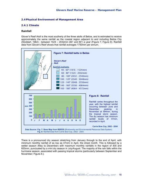
2.4 Physical Environment of <strong>Management</strong> Area<br />
2.4.1 Climate<br />
Rainfall<br />
Glovers <strong>Reef</strong> <strong>Marine</strong> <strong>Reserve</strong> – <strong>Management</strong> <strong>Plan</strong><br />
Glover’s <strong>Reef</strong> Atoll is the most southerly of the three atolls of Belize, and is estimated to receive<br />
approximately the same rainfall as the coastal region adjacent to and including Belize City<br />
(Stoddart, 1962) - between 1524 – 2032mm (60” and 80”) a year (Figure 7; Figure 8). Rainfall<br />
data from Glover’s <strong>Reef</strong> shows that rainfall averages 1750mm per annum.<br />
700<br />
600<br />
500<br />
mm 400<br />
300<br />
200<br />
100<br />
0<br />
Figure 7: Rainfall belts in Belize<br />
Glover’s <strong>Reef</strong><br />
Atoll<br />
Rainfall Isohyets<br />
40 - 60" (1016 - 1524mm)<br />
60 - 80" (1524 - 2032mm)<br />
80 - 100" (2032 - 2540mm)<br />
100 - 120" (2540 - 3048mm)<br />
120 - 140" (3048 - 3556mm)<br />
140 - 160" (3556 - 4064mm)<br />
160 - 180" (4064 - 4572mm)<br />
J F M A M J J A S O N D<br />
Figure 8: Rainfall<br />
Rainfall varies throughout the<br />
year, with the highest rainfall<br />
occurring between June and<br />
December, peaking in<br />
November at 594mm, during<br />
the tropical storm season.<br />
The dry season has minimum<br />
rainfall levels of 47mm,<br />
recorded in April.<br />
Carrie Bow Cay, 2002 - 2004<br />
Data Source: Fig. 7: Base Map from BERDS (Biodiversity and Environmental Resource Data System)<br />
Fig. 8: Rainfall Data from Carrie Bow Cay, 2002 - 2004.<br />
There is a pronounced dry season stretching from January through to the end of April, with<br />
minimum monthly rainfall of as low as 47mm in April, the driest month. This is followed by a<br />
wetter season (May to December) with maximum monthly rainfalls in the region of 300 and<br />
600mm, punctuated by a mini dry season in July/August. The majority of the rain falls within the<br />
hurricane season, associated with passing tropical storms (particularly between September and<br />
November; Figure 8.).<br />
Wildtracks / Wildlife Conservation Society, 2007 18