Management Plan - Glover's Reef Marine Reserve
Management Plan - Glover's Reef Marine Reserve
Management Plan - Glover's Reef Marine Reserve

You also want an ePaper? Increase the reach of your titles
YUMPU automatically turns print PDFs into web optimized ePapers that Google loves.
Peripheral <strong>Reef</strong>s<br />
Glovers <strong>Reef</strong> <strong>Marine</strong> <strong>Reserve</strong> – <strong>Management</strong> <strong>Plan</strong><br />
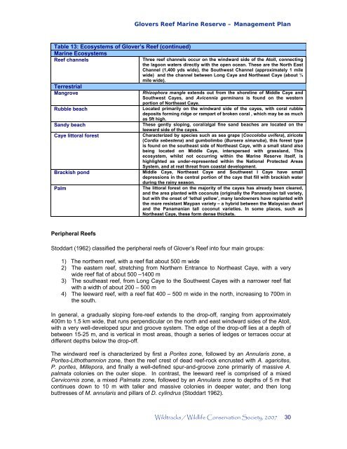
Table 13: Ecosystems of Glover’s <strong>Reef</strong> (continued)<br />
<strong>Marine</strong> Ecosystems<br />
<strong>Reef</strong> channels Three reef channels occur on the windward side of the Atoll, connecting<br />
the lagoon waters directly with the open ocean. These are the North East<br />
Channel (1,400 yds wide), the Southwest Channel (approximately 1 mile<br />
wide) and the channel between Long Caye and Northeast Caye (about ¼<br />
mile wide).<br />
Terrestrial<br />
Mangrove Rhizophora mangle extends out from the shoreline of Middle Caye and<br />
Southwest Cayes, and Avicennia germinans is found on the western<br />
portion of Northeast Caye.<br />
Rubble beach<br />
Located primarily on the windward side of the cayes, with coral rubble<br />
deposits forming ridge or rampart of broken coral , which may be as much<br />
as 5ft high.<br />
Sandy beach<br />
These gently sloping, coral/algal fine sand beaches are located on the<br />
leeward side of the cayes.<br />
Caye littoral forest Characterized by species such as sea grape (Coccoloba uvifera), ziricote<br />
(Cordia sebestena) and gumbolimbo (Bursera simaruba), this forest type<br />
is found on the southeast side of Northeast Caye, with a small stand also<br />
being located on Middle Caye, interspersed with grassland, This<br />
ecosystem, whilst not occurring within the <strong>Marine</strong> <strong>Reserve</strong> itself, is<br />
highlighted as under-represented within the National Protected Areas<br />
System, and at reat threat from coastal development.<br />
Brackish pond<br />
Middle Caye, Northeast Caye and Southwest I Caye have small<br />
depressions in the central portion of the caye that fill with brackish water<br />
during the rainy season.<br />
Palm<br />
The littoral forest on the majority of the cayes has already been cleared,<br />
and the area planted with coconuts (originally the Panamanian tall variety,<br />
but with the onset of ‘lethal yellow’, many landowners have replanted with<br />
the more resistant Maypan variety – a hybrid between the Malaysian dwarf<br />
and the Panamanian tall coconut varieties. In some places, such as<br />
Northeast Caye, these form dense thickets.<br />
Stoddart (1962) classified the peripheral reefs of Glover’s <strong>Reef</strong> into four main groups:<br />
1) The northern reef, with a reef flat about 500 m wide<br />
2) The eastern reef, stretching from Northern Entrance to Northeast Caye, with a very<br />
wide reef flat of about 500 –1400 m<br />
3) The southeast reef, from Long Caye to the Southwest Cayes with a narrower reef flat<br />
with a width of about 200 – 500 m<br />
4) The leeward reef, with a reef flat 400 – 500 m wide in the north, increasing to 700m in<br />
the south.<br />
In general, a gradually sloping fore-reef extends to the drop-off, ranging from approximately<br />
400m to 1.5 km wide, that runs perpendicular on the north and east windward sides of the Atoll,<br />
with a very well-developed spur and groove system. The edge of the drop-off lies at a depth of<br />
between 15-25 m, and is vertical in most areas, though a series of ledges or terraces occur at<br />
different depths below the drop-off.<br />
The windward reef is characterized by first a Porites zone, followed by an Annularis zone, a<br />
Porites-Lithothamnion zone, then the reef crest of dead reef-rock encrusted with A. agaricites,<br />
P. porites, Millepora, and finally a well-defined spur-and-groove zone primarily of massive A.<br />
palmata colonies on the outer slope. In contrast, the leeward reef is comprised of a mixed<br />
Cervicornis zone, a mixed Palmata zone, followed by an Annularis zone to depths of 5 m that<br />
continues down to 10 m with taller and massive colonies in deeper water, and then long<br />
buttresses of M. annularis and pillars of D. cylindrus (Stoddart 1962).<br />
Wildtracks / Wildlife Conservation Society, 2007 30