Management Plan - Glover's Reef Marine Reserve
Management Plan - Glover's Reef Marine Reserve
Management Plan - Glover's Reef Marine Reserve

You also want an ePaper? Increase the reach of your titles
YUMPU automatically turns print PDFs into web optimized ePapers that Google loves.
Glovers <strong>Reef</strong> <strong>Marine</strong> <strong>Reserve</strong> – <strong>Management</strong> <strong>Plan</strong><br />
eastern tip of the island – almost certainly as the result of less aggressive beach clearance<br />
activities (Walker, 2007). In the late 1990’s the island’s coconut trees became highly infected<br />
with lethal yellowing disease (Berlin & Quiroz 1998), and a total of 150 hybrid Maypan diseaseresistant<br />
coconut trees were subsequently planted to replace some of those that had died, near<br />
the facilities. On the remaining area of the island, the untreated trees died rapidly and many<br />
were removed (Bright 1999).<br />
A non-exhaustive survey of the flora of Middle Caye (Walker,<br />
2007) demonstrated that, in the absence of the negative<br />
impacts associated with invasive coconuts, the native flora and<br />
vegetation assemblages are re-establishing very well, with<br />
native species assemblages being established over much of the<br />
island, greatly increasing the extent and condition of natural<br />
vegetation, and enhancing habitat quality for the fauna. A total<br />
of 31 species of plant were identified in the survey, not including<br />
most of the grasses, and not including at least one more<br />
unidentified herbaceous species. Species richness is evidently<br />
increasing as a direct result of the reduction of the coconut<br />
abundance, and as a result of more environmentally-friendly<br />
management. It would appear that overall species richness is<br />
rapidly returning to natural levels, though it can be expected<br />
that habitat structure will continue to change significantly over<br />
coming years as woody shrubs and trees extend the current<br />
limits of the littoral forest into some of the areas currently<br />
dominated by herbaceous beach flora. Current management<br />
(pruning of taller growth, to maintain a vista) of a significant<br />
portion of the northern portion of the island has provided a<br />
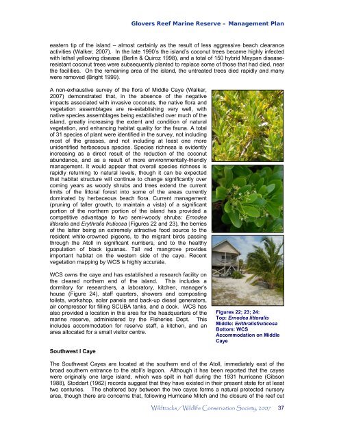
competitive advantage to two semi-woody shrubs: Ernodea<br />
littoralis and Erythralis fruticosa (Figures 22 and 23), the berries<br />
of the latter being an extremely attractive food source to the<br />
resident white-crowned pigeons, to the migrant birds passing<br />
through the Atoll in significant numbers, and to the healthy<br />
population of black iguanas. Tall red mangrove provides<br />
important habitat on the western side of the caye. Recent<br />
vegetation mapping by WCS is highly accurate.<br />
WCS owns the caye and has established a research facility on<br />
the cleared northern end of the island. This includes a<br />
dormitory for researchers, a laboratory, kitchen, manager’s<br />
house (Figure 24), staff quarters, showers and composting<br />
toilets, workshop, solar panels and back-up diesel generators,<br />
air compressor for filling SCUBA tanks, and a dock. WCS has<br />
also provided a location in this area for the headquarters of the<br />
marine reserve, administered by the Fisheries Dept. This<br />
includes accommodation for reserve staff, a kitchen, and an<br />
area allocated for a small visitor centre.<br />
Southwest I Caye<br />
Figures 22; 23; 24:<br />
Top: Ernodea littoralis<br />
Middle: Erithralisfruticosa<br />
Bottom: WCS<br />
Accommodation on Middle<br />
Caye<br />
The Southwest Cayes are located at the southern end of the Atoll, immediately east of the<br />
broad southern entrance to the atoll’s lagoon. Although it has been reported that the cayes<br />
were originally one large island, which was spilt in half during the 1931 hurricane (Gibson<br />
1988), Stoddart (1962) records suggest that they have existed in their present state for at least<br />
two centuries. The sheltered bay between the two cayes forms a natural protected nursery<br />
area, though there are concerns that, following Hurricane Mitch and the closure of the reef cut<br />
Wildtracks / Wildlife Conservation Society, 2007 37