

Quantification des flux sédimentaires et de la subsidence du bassin ...
Quantification des flux sédimentaires et de la subsidence du bassin ...
Quantification des flux sédimentaires et de la subsidence du bassin ...

You also want an ePaper? Increase the reach of your titles
YUMPU automatically turns print PDFs into web optimized ePapers that Google loves.
tel-00790852, version 1 - 21 Feb 2013<br />
(a)<br />
uncertainties about the pa<strong>la</strong>eo-water <strong>de</strong>pth estimates for<br />
the Trubi <strong>de</strong>position. Using quantitative studies on benthic<br />
foraminifers, Brolsma (1978) proposed 100–1000 m,<br />
whereas Cita & Colombo (1979) proposed 1400–2400 m,<br />
using benthic foraminifers and the sharp sedimentary<br />
contrast b<strong>et</strong>ween the uppermost Messinian and lowermost<br />
Zanclean <strong>de</strong>posits, in both exposed sections and<br />
DSDP (Deep Sea Drilling Project) wells. Disagreement<br />
(c)<br />
(b)<br />
Post-Messinian Crisis Mediterranean reflooding<br />
Fig. 8. Ligo 54 profile crossing the<br />
GLP2 borehole. The erosional nature of<br />
the p<strong>la</strong>nation surface ‘e’ and the transgressive<br />
nature of sediments <strong>de</strong>posited<br />
above it are outlined by arrows. The<br />
50 m of azoic sand <strong><strong>de</strong>s</strong>cribed in the<br />
GLP2 borehole could correspond to the<br />
transgressive sands ero<strong>de</strong>d from<br />
upstream by the wave erosion (p<strong>la</strong>nation<br />
surface ‘e’). Location of seismic profiles<br />
on Fig. 6. See uninterpr<strong>et</strong>ed seismic profile<br />
on Fig. S3.<br />
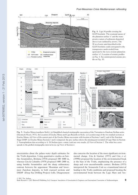
Fig. 9. Eraclea Minoa (southern Sicily). (a) Simplified c<strong>la</strong>ssical stratigraphic succession of the Tortonian to Zanclean Sicilian series<br />
(Decima & Wezel, 1971). (b) Location of Eraclea Minoa and Capo Rossello in Sicily. (c) Location map of the two studied sections at<br />
Eraclea Minoa. (d) View of the eastern part of the Eraclea Minoa succession with location of Sections 1 and 2, and of the Zanclean<br />
Stage GSSP. (e) Eraclea Minoa Sections 1 and 2 compared: the grey surface shows the missing part (ero<strong>de</strong>d) of Lago Mare in Section<br />
2. Nannop<strong>la</strong>nkton data according to A. Di Stefano (pers. comm.) and our own results. (f) View of Section 1. The white box corresponds<br />
to the girdled stratigraphic interval in (a). (g) View of Section 2.<br />
(e)<br />
(f)<br />
also concerns the location of the most significant environmental<br />
change. Cita & Gartner (1973) and Cita <strong>et</strong> al.<br />
(1999b) proposed the location of the environmental break<br />
at the base of the Trubi, emphasizing the presence of a<br />
sharp and even unconformable contact. Brolsma (1975)<br />
interpr<strong>et</strong>ed the Arenazzolo Unit as a transitional interval<br />
leading to the Trubi conditions and proposed locating the<br />
environmental break b<strong>et</strong>ween the Lago Mare and Are-<br />
© 2011 The Authors<br />
Basin Research © 2011 B<strong>la</strong>ckwell Publishing Ltd, European Association of Geoscientists & Engineers and International Association of Sedimentologists 9<br />
(g)<br />
(d)


