

Quantification des flux sédimentaires et de la subsidence du bassin ...
Quantification des flux sédimentaires et de la subsidence du bassin ...
Quantification des flux sédimentaires et de la subsidence du bassin ...

Create successful ePaper yourself
Turn your PDF publications into a flip-book with our unique Google optimized e-Paper software.
tel-00790852, version 1 - 21 Feb 2013<br />
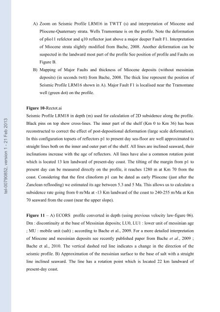
A) Zoom on Seismic Profile LRM16 in TWTT (s) and interpr<strong>et</strong>ation of Miocene and<br />
Pliocene-Quaternary strata. Wells Tramontane is on the profile. Note the <strong>de</strong>formation<br />
of plio11 refelctor and q10 reflector just above a major <strong>de</strong>eper Fault F1. Interpr<strong>et</strong>ation<br />
of Miocene strata slightly modified from Bache, 2008. Another <strong>de</strong>formation can be<br />
suspected in the <strong>la</strong>ndward most part of the profile See position of profile and Faults on<br />
Figure B.<br />
B) Mapping of Major Faults and thickness of Miocene <strong>de</strong>posits (without messinian<br />
<strong>de</strong>posits) (in seconds twtt) from Bache, 2008. The thick line represent the position of<br />
Seismic Profile LRM16 shown in A). Major Fault F1 is localised near the Tramontane<br />
well (green dot) on the profile.<br />
Figure 10-Rectot.ai<br />
Seismic Profile LRM18 in <strong>de</strong>pth (m) used for calcu<strong>la</strong>tion of 2D subsi<strong>de</strong>nce along the profile.<br />
B<strong>la</strong>ck pins on top show cross-lines. The inner part of the shelf (Km 0 to Km 36) has been<br />
reconstructed to correct the effect of post-<strong>de</strong>positional <strong>de</strong>formation (<strong>la</strong>rge scale <strong>de</strong>formation).<br />
In this configuration tops<strong>et</strong>s of reflectors p1 to present day sea-floor are well approximated to<br />
straight lines both on the inner and outer part of the shelf. All lines are inclined seaward, their<br />
inclinations increase with the age of reflectors. All lines have also a common rotation point<br />
which is located 13 km <strong>la</strong>ndward of present-day coast. The tilting of the margin from p1 to<br />
present day can be measured directly on the profile, it reaches 1280 m at Km 70 from the<br />
coast. Consi<strong>de</strong>ring that the first clinoform p1 can be dated as early Pliocene (just after the<br />
Zanclean reflooding) we estimated its age b<strong>et</strong>ween 5.3 and 5 Ma. This allows us to calcu<strong>la</strong>te a<br />
subsi<strong>de</strong>nce rate going from 0 m/Ma at -13 Km <strong>la</strong>ndward of the coast to 240-255 m/Ma at Km<br />
70 seaward from the coast (near the upper slope).<br />
Figure 11 – A) ECORS profile converted in <strong>de</strong>pth (using previous velocity <strong>la</strong>w-figure 06).<br />
Dm : discontinuity at the base of Messinian <strong>de</strong>posits; LU0, LU1 : lower unit of messinian age<br />
; MU : mobile unit (salt) ; according to Bache <strong>et</strong> al., 2009. For a more d<strong>et</strong>ailed interpr<strong>et</strong>ation<br />
of Miocene and messinian <strong>de</strong>posits see recently published paper from Bache <strong>et</strong> al., 2009 ;<br />
Bache <strong>et</strong> al., 2010. The vertical dashed red line indicates a change in the direction of the<br />
seismic profile. B) Approximation of the messinian surface to the base of salt with a straight<br />
line inclined seaward. The line has a rotation point which is located 22 km <strong>la</strong>ndward of<br />
present-day coast.


