

Quantification des flux sédimentaires et de la subsidence du bassin ...
Quantification des flux sédimentaires et de la subsidence du bassin ...
Quantification des flux sédimentaires et de la subsidence du bassin ...

Create successful ePaper yourself
Turn your PDF publications into a flip-book with our unique Google optimized e-Paper software.
tel-00790852, version 1 - 21 Feb 2013<br />
F. Bache <strong>et</strong> al.<br />
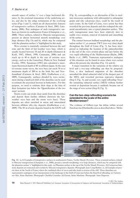
smooth aspect of surface ‘e’ over a <strong>la</strong>rge horizontal distance,<br />
by the erosional truncations of the un<strong>de</strong>rlying series,<br />
and also by the on<strong>la</strong>p termination of the overlying<br />
series (Figs 5 and 7), which are all characteristic features<br />
of transgressive surfaces (Cattaneo & Steel, 2003; Catuneanu,<br />
2006). Past analogues of such transgressive surfaces<br />
are known in southeastern France (Champion <strong>et</strong> al.,<br />
2000). These surfaces, re<strong>la</strong>ted to Miocene transgressions,<br />
present an almost horizontal smooth morphology over<br />
<strong>la</strong>rge distance (Fig 13a and b), which may be compared<br />
with the p<strong>la</strong>nation surface ‘e’ highlighted in this study.<br />
Wave erosion is essentially contained b<strong>et</strong>ween the surf<br />
zone and the limit of fair-weather wave base, which is<br />
usually located b<strong>et</strong>ween 10 and 20 m <strong>de</strong>pth (Demarest &<br />
Kraft, 1987; Abbott, 1998; Catuneanu, 2006) and can<br />
reach up to 40 m <strong>de</strong>pth in the case of extreme wave<br />
energy, such as in the Canterbury P<strong>la</strong>ins in New Zea<strong>la</strong>nd<br />
(Leckie, 1994). Sunamura (1987) also calcu<strong>la</strong>ted a maximum<br />
theor<strong>et</strong>ical <strong>de</strong>pth of 40 m offshore Japan. In the case<br />
of extreme storm waves, the wave base can reach 70 m to<br />
maximum <strong>de</strong>pth of 200 m in the Irish Sea and Newfound<strong>la</strong>nd<br />
(Cattaneo & Steel, 2003; Guillocheau <strong>et</strong> al.,<br />
2009). Consequently, surfaces abra<strong>de</strong>d by wave ravinement<br />
<strong>du</strong>ring a <strong>la</strong>ndward shift of the shoreline can be used<br />
to estimate the associated increase in bathym<strong>et</strong>ry. For this<br />
purpose, we need to estimate their slope at the time of<br />
their formation (see below the ‘<strong>Quantification</strong> of the two<br />
steps’ section).<br />
Storm events can ero<strong>de</strong> clean sands from the shoreface<br />
and <strong>de</strong>posit them further offshore (b<strong>et</strong>ween the fairweather<br />
wave base and the storm wave base). These<br />
<strong>de</strong>posits are often enriched in micas and interca<strong>la</strong>ted<br />
b<strong>et</strong>ween offshore silty-c<strong>la</strong>y <strong>de</strong>posits (Guillocheau <strong>et</strong> al.,<br />
2009). The 50 m of azoic <strong>de</strong>posits found in the GLP2 well<br />
(b)<br />
(Fig. 8), corresponding to an alternation of fine to medium<br />
micaceous sandstone with subroun<strong>de</strong>d to subangu<strong>la</strong>r<br />
grains and silty calcareous c<strong>la</strong>ys, could be the result of<br />
such events. In the Gulf of Lions, wave action has thus<br />
reworked the previous <strong>de</strong>posits and also reshaped the subaerial<br />
unconformity into a typical p<strong>la</strong>nation surface. This<br />
early transgression must have been re<strong>la</strong>tively slow to<br />
enable wave erosion, removal of material and smoothing<br />
of the surface.<br />
The contact b<strong>et</strong>ween bad<strong>la</strong>nd morphology and the p<strong>la</strong>nation<br />
surface ‘e’, at constant TWT (two-way time) <strong>de</strong>pth<br />
throughout the Gulf of Lions (Fig. 7), has been interpr<strong>et</strong>ed<br />
as indicating the location of the pa<strong>la</strong>eoshoreline<br />
at the end of the wave erosion phase and just before the<br />
very rapid reflooding of the Mediterranean (Bache, 2008;<br />
Bache <strong>et</strong> al., 2009). Numerous representative analogues<br />
of this situation can be found in areas where wave action<br />
affects the present-day shoreline (Fig. 13c and d).<br />
A major transition in the variations of the re<strong>la</strong>tive sea<br />
level and a two-step reflooding can thus be proposed.<br />
First, a slow <strong>la</strong>ndward migration of the shoreline<br />
smoothed the distal subaerial relief of the <strong>de</strong>epest part of<br />
the MES, and reworked previous regressive <strong>de</strong>posits<br />
(Step I; Fig. 5); and second, very rapid reflooding ‘froze’<br />
the remaining subaerial surface (MES) without further<br />
erosion or <strong>de</strong>position because it sud<strong>de</strong>nly became out of<br />
the range of wave action (Step II; Fig. 5).<br />
Can the two-step reflooding scenario be<br />
exten<strong>de</strong>d to the scale of the entire<br />
Mediterranean?<br />
The evi<strong>de</strong>nce of Gilbert-type fan <strong>de</strong>ltas within several<br />
Zanclean rias (Dardanelles area as <strong><strong>de</strong>s</strong>cribed above: Melin-<br />
Fig. 13. (a, b) Examples of transgressive surfaces in southeastern France, Nerthe Massif, Provence. These erosional surfaces, re<strong>la</strong>ted<br />
to Miocene transgressions (Champion <strong>et</strong> al., 2000), present a smooth morphology over <strong>la</strong>rge distances, which may be compared with<br />
the p<strong>la</strong>nation surface ‘e’ highlighted in this study. (a) P<strong>la</strong>nation surface at the top of the Nerthe Massif, Provence. (b) Cr<strong>et</strong>aceous limestone<br />
<strong>de</strong>posits are truncated and over<strong>la</strong>in by Miocene transgressive <strong>de</strong>posits. Photograph: Jean-Loup Rubino. (c, d) Examples of present<br />
shore in the North of France where the combined effect of waves and ti<strong><strong>de</strong>s</strong> leads to erosion of the cliff. These shorelines are<br />
representative analogues of our interpr<strong>et</strong>ation of the <strong>la</strong>ndscape in the Gulf of Lions just before the Step II of reflooding. (c) Vatt<strong>et</strong>otsur-Mer,<br />
Seine Maritime. Photograph: Charlélie Coutinho. (d) Etr<strong>et</strong>at, Seine-Maritime. Photograph: Anne Duperr<strong>et</strong>.<br />
14<br />
© 2011 The Authors<br />
Basin Research © 2011 B<strong>la</strong>ckwell Publishing Ltd, European Association of Geoscientists & Engineers and International Association of Sedimentologists<br />
(a)<br />
(c)<br />
(d)


