Geometry and Spatial Sense, Grades 4 to 6 - EduGains
Geometry and Spatial Sense, Grades 4 to 6 - EduGains
Geometry and Spatial Sense, Grades 4 to 6 - EduGains

You also want an ePaper? Increase the reach of your titles
YUMPU automatically turns print PDFs into web optimized ePapers that Google loves.
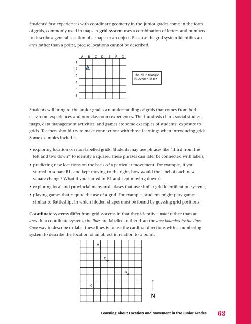
Students’ first experiences with coordinate geometry in the junior grades come in the form<br />
of grids, commonly used in maps. A grid system uses a combination of letters <strong>and</strong> numbers<br />
<strong>to</strong> describe a general location of a shape or an object. Because the grid system identifies an<br />
area rather than a point, precise locations cannot be described.<br />
Students will bring <strong>to</strong> the junior grades an underst<strong>and</strong>ing of grids that comes from both<br />
classroom experiences <strong>and</strong> non-classroom experiences. The hundreds chart, social studies<br />
maps, data management activities, <strong>and</strong> games are some examples of students’ exposure <strong>to</strong><br />
grids. Teachers should try <strong>to</strong> make connections with those learnings when introducing grids.<br />
Some examples include:<br />
1<br />
2<br />
3<br />
4<br />
5<br />
6<br />
A<br />
B C D E F G<br />
The blue triangle<br />
is located in B2.<br />
• exploring location on non-labelled grids. Students may use phrases like “third from the<br />
left <strong>and</strong> two down” <strong>to</strong> identify a square. These phrases can later be connected with labels;<br />
• predicting new locations on the basis of a particular movement. For example, if you<br />
started in square B1, <strong>and</strong> kept moving <strong>to</strong> the right, how would the label of each new<br />
square change? What if you started in B1 <strong>and</strong> kept moving down?;<br />
• exploring local <strong>and</strong> provincial maps <strong>and</strong> atlases that use similar grid identification systems;<br />
• playing games that require the use of a grid. For example, students might play games<br />
similar <strong>to</strong> Battleship, in which hidden shapes must be found by guessing grid positions.<br />
Coordinate systems differ from grid systems in that they identify a point rather than an<br />
area. In a coordinate system, the lines are labelled, rather than the area bounded by the lines.<br />
One way <strong>to</strong> describe or label these lines is <strong>to</strong> use the cardinal directions with a numbering<br />
system <strong>to</strong> describe the location of an object in relation <strong>to</strong> a point.<br />
C<br />
A<br />
O<br />
B<br />
Learning About Location <strong>and</strong> Movement in the Junior <strong>Grades</strong> 6