

Engineering geology of British rocks and soils Mudstones of the ...
Engineering geology of British rocks and soils Mudstones of the ...
Engineering geology of British rocks and soils Mudstones of the ...

Create successful ePaper yourself
Turn your PDF publications into a flip-book with our unique Google optimized e-Paper software.
2 Geological background<br />
2.1 GLOBAL SETTING<br />
The crustal plates <strong>of</strong> <strong>the</strong> Earth's surface moved toge<strong>the</strong>r<br />
during <strong>the</strong> late Carboniferous Period resulting in <strong>the</strong> fusion <strong>of</strong><br />
all <strong>the</strong> continental masses to form <strong>the</strong> single, super continent<br />
<strong>of</strong> Pangea (Figure 2.1). However, at <strong>the</strong> start <strong>of</strong> <strong>the</strong> Permian<br />
tensional stresses within <strong>the</strong> super continent resulted in <strong>the</strong><br />
formation <strong>of</strong> a large infra-continental basin at a latitude <strong>of</strong> 15<br />
to 20 north <strong>of</strong> <strong>the</strong> equator. This is a similar geographical<br />
location on <strong>the</strong> Earth’s surface to that <strong>of</strong> <strong>the</strong> current position<br />
<strong>of</strong> <strong>the</strong> Sahara Desert in nor<strong>the</strong>rn Africa. This rifting was to<br />
lead ultimately to <strong>the</strong> opening <strong>of</strong> <strong>the</strong> Atlantic Ocean far<strong>the</strong>r to<br />
<strong>the</strong> west. To <strong>the</strong> south, <strong>the</strong> Variscan mountain range <strong>of</strong> <strong>the</strong><br />
Hercynian fold belt separated <strong>the</strong> developing basin from <strong>the</strong><br />
Tethys Ocean <strong>and</strong> <strong>the</strong> continental mass that was to become<br />
Africa. To <strong>the</strong> north lay <strong>the</strong> l<strong>and</strong>mass created when Laurentia<br />
had fused with Greenl<strong>and</strong> <strong>and</strong> Fenno-Sc<strong>and</strong>ia to form<br />
Laurasia (Figure 2.2).<br />
The climate <strong>of</strong> <strong>the</strong> basin was interpreted by Warrington<br />
<strong>and</strong> Ivimey-Cook (1992) as being <strong>of</strong> a monsoonal nature with<br />
prevailing winds from <strong>the</strong> north-east or east. When <strong>the</strong> wind<br />
met <strong>the</strong> Variscan mountains it resulted in high rainfall events<br />
which led to periodic floods draining northward into <strong>the</strong><br />
basin. The deposits <strong>of</strong> <strong>the</strong> Triassic Period in what is now<br />
called nor<strong>the</strong>rn Europe were laid down within this<br />
framework. The Triassic Period extended from about 250 Ma<br />
to 205 Ma before <strong>the</strong> present time (Forster <strong>and</strong> Warrington,<br />
1985) <strong>and</strong> derives its name 'Triassic' from <strong>the</strong> threefold<br />
lithostratigraphic division, recognised in Germany, <strong>of</strong><br />
Bunts<strong>and</strong>stein (s<strong>and</strong>stone), Muschelkalk (carbonate) <strong>and</strong><br />
Keuper (mudstone). However, in Britain, which is on <strong>the</strong><br />
Figure 2.1 Supercontinent <strong>of</strong> Pangea in <strong>the</strong> late<br />
Carboniferous Period 325 million years ago formed by <strong>the</strong><br />
collision <strong>of</strong> <strong>the</strong> continental masses <strong>of</strong> Laurasia <strong>and</strong><br />
Gondwana (after Keary <strong>and</strong> Vine, 1990).<br />
2<br />
0 1000 km<br />
LAURENTIAN–GREENLAND SHIELD<br />
RH<br />
CSB<br />
RT<br />
WA<br />
FR<br />
M<br />
MNS<br />
NO RTH<br />
NPB<br />
CHESHIRE BASIN<br />
EIS SPB<br />
WB<br />
WC<br />
ATLANTIC – ARCTIC RIFT<br />
FENNO–SCANDIAN SHIELD<br />
VARISCAN FRONT<br />
western margin <strong>of</strong> <strong>the</strong> basin, this three-fold division does not<br />
represent <strong>the</strong> local sequence. The Muschelkalk facies is<br />
missing <strong>and</strong> Triassic <strong>rocks</strong> are represented by <strong>the</strong> Sherwood<br />
S<strong>and</strong>stone Group (formerly Bunter S<strong>and</strong>stone), Mercia<br />
Mudstone Group (formerly Keuper Marl) <strong>and</strong> <strong>the</strong> Penarth<br />
Group (formerly <strong>the</strong> Rhaetic). These have been described by<br />
Warrington <strong>and</strong> Ivimey-Cook (1992) who identified five<br />
lithological associations within <strong>the</strong> Triassic (Figure 2.3).<br />
The lowest division, below <strong>the</strong> Hardegsen<br />
Disconformity, comprises an unfossiliferous sequence <strong>of</strong><br />
s<strong>and</strong>stone, pebbly s<strong>and</strong>stone <strong>and</strong> conglomeratic s<strong>and</strong>stone<br />
laid down as channel deposits in a braided stream fluvial<br />
environment <strong>of</strong> a major, northward-flowing river system.<br />
This environment lasted for approximately seven million<br />
years at <strong>the</strong> start <strong>of</strong> <strong>the</strong> Triassic Period (Scythian) <strong>and</strong> <strong>the</strong><br />
deposits are now preserved as <strong>the</strong> lower part <strong>of</strong> <strong>the</strong><br />
Sherwood S<strong>and</strong>stone Group. Above this is a complex<br />
basinal sequence, between <strong>the</strong> Hardegsen unconformity<br />
<strong>and</strong> <strong>the</strong> Arden S<strong>and</strong>stone <strong>and</strong> its equivalents, which spans<br />
about 20 million years from Scythian to Carnian times.<br />
During <strong>the</strong> early part <strong>of</strong> this period <strong>the</strong> regional climate<br />
became progressively more arid <strong>and</strong> inl<strong>and</strong> sabkhas, saline<br />
mudflats <strong>and</strong> temporary lakes slowly advanced southwards<br />
VG<br />
LBM<br />
PB<br />
R F<br />
OG<br />
VARISCAN MOUNTAINS<br />
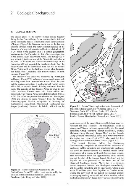
Figure 2.2 Permo-Triassic regional tectonic framework <strong>of</strong><br />
<strong>the</strong> North Atlantic region. CB = Cheshire Basin, WB =<br />
Worcester Basin, WC = Wessex Basin, NPB = North<br />
Permian Basin, SPB = South Permian Basin, LBM =<br />
London Brabant Massif (after Chadwick <strong>and</strong> Evans, 1995).


