International Field Workshop on 'The Triassic of eastern France'
International Field Workshop on 'The Triassic of eastern France'
International Field Workshop on 'The Triassic of eastern France'

You also want an ePaper? Increase the reach of your titles
YUMPU automatically turns print PDFs into web optimized ePapers that Google loves.
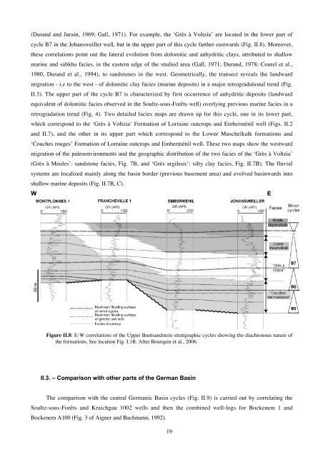
(Durand and Jurain, 1969; Gall, 1971). For example, the ‘Grès à Voltzia’ are located in the lower part <strong>of</strong><br />
cycle B7 in the Johansweiller well, but in the upper part <strong>of</strong> this cycle farther eastwards (Fig. II.8). Moreover,<br />
these correlati<strong>on</strong>s point out the lateral evoluti<strong>on</strong> from dolomitic and anhydritic clays, attributed to shallow<br />
marine and sabkha facies, in the <strong>eastern</strong> edge <strong>of</strong> the studied area (Gall, 1971; Durand, 1978; Courel et al.,<br />
1980, Durand et al., 1994), to sandst<strong>on</strong>es in the west. Geometrically, the transect reveals the landward<br />
migrati<strong>on</strong> - i.e to the west - <strong>of</strong> dolomitic clay facies (marine deposits) in a major retrogradati<strong>on</strong>al trend (Fig.<br />
II.3). The upper part <strong>of</strong> the cycle B7 is characterized by first occurrence <strong>of</strong> anhydritic deposits (landward<br />
equivalent <strong>of</strong> dolomitic facies observed in the Soultz-sous-Forêts well) overlying previous marine facies in a<br />
retrogradati<strong>on</strong> trend (Fig. 4). Two detailed facies maps are drawn up for this cycle, <strong>on</strong>e in its lower part,<br />
which corresp<strong>on</strong>d to the ‘Grès à Voltzia’ Formati<strong>on</strong> <strong>of</strong> Lorraine outcrops and Emberménil well (Figs. II.2<br />
and II.7), and the other in its upper part which corresp<strong>on</strong>d to the Lower Muschelkalk formati<strong>on</strong>s and<br />
‘Couches rouges’ Formati<strong>on</strong> <strong>of</strong> Lorraine outcrops and Emberménil well. These two maps show the westward<br />
migrati<strong>on</strong> <strong>of</strong> the paleoenvir<strong>on</strong>ments and the geographic distributi<strong>on</strong> <strong>of</strong> the two facies <strong>of</strong> the ‘Grès à Voltzia’<br />
(Grès à Meules’: sandst<strong>on</strong>e facies, Fig. 7B, and ‘Grès argileux’: silty clay facies, Fig. II.7B). The fluvial<br />
systems are localized mainly al<strong>on</strong>g the basin border (previous basement area) and evolved basinwards into<br />
shallow marine deposits (Fig. II.7B, C).<br />
Figure II.8: E-W correlati<strong>on</strong>s <strong>of</strong> the Upper Buntsandstein stratigraphic cycles showing the diachr<strong>on</strong>ous nature <strong>of</strong><br />
the formati<strong>on</strong>s. See locati<strong>on</strong> Fig. I.1B. After Bourquin et al., 2006.<br />
II.3. – Comparis<strong>on</strong> with other parts <strong>of</strong> the German Basin<br />
The comparis<strong>on</strong> with the central Germanic Basin cycles (Fig. II.9) is carried out by correlating the<br />
Soultz-sous-Forêts and Kraichgau 1002 wells and then the combined well-logs for Bockenem 1 and<br />
Bockenem A100 (Fig. 3 <strong>of</strong> Aigner and Bachmann, 1992).<br />
19