Potomac Waterfront Flood Mitigation Study - City of Alexandria
Potomac Waterfront Flood Mitigation Study - City of Alexandria
Potomac Waterfront Flood Mitigation Study - City of Alexandria

Create successful ePaper yourself
Turn your PDF publications into a flip-book with our unique Google optimized e-Paper software.
TABLE OF CONTENTS<br />
FIGURES<br />
Figure 1-1: Lower King Street Area after Hurricane Isabel, 2003..............................................1-2<br />
Figure 1-2: Focus Areas.............................................................................................................1-4<br />
Figure 2-1: Inundation Areas for Selected <strong>Flood</strong> Level Categories............................................2-2<br />
Figure 2-2: <strong>Flood</strong> Levels Studied...............................................................................................2-3<br />
Figure 3-1: <strong>Flood</strong>gate.................................................................................................................3-3<br />
Figure 3-2: Three-Foot Dry <strong>Flood</strong>pro<strong>of</strong>ing Limitation...............................................................3-4<br />
Figure 3-3: <strong>Flood</strong>ed Building.....................................................................................................3-4<br />
Figure 3-4: LAG Elevated to Protect Building from <strong>Flood</strong>ing ...................................................3-5<br />
Figure 3-5: <strong>Flood</strong>pro<strong>of</strong> Door......................................................................................................3-6<br />
Figure 4-1: Calculated <strong>Flood</strong> Zone Compared to FEMA <strong>Flood</strong> Zones.......................................4-2<br />
Figure 4-2: Structures Predicted to be <strong>Flood</strong>ed for Each <strong>Flood</strong> Event........................................4-4<br />
Figure 6-1: Proposed <strong>Flood</strong>wall Layout.....................................................................................6-4<br />
Figure 6-2: Interior Drainage Area <strong>of</strong> Proposed <strong>Flood</strong>wall ........................................................6-6<br />
Figure 6-3: Proposed Elevated Walkway Cross-Section ..........................................................6-11<br />
Figure 6-4: Proposed Elevated Walkway Layout .....................................................................6-13<br />
Figure 6-5: Interior Drainage Area <strong>of</strong> Proposed Elevated Walkway ........................................6-14<br />
Figure 6-6: Proposed Jones Point Berm Layout .......................................................................6-20<br />
Figure 6-7: Interior Drainage Area for Jones Point Berm Drainage Area.................................6-22<br />
Figure 6-8: Area <strong>of</strong> Proposed Regrading..................................................................................6-27<br />
Figure 6-9: Jones Point Focus Area <strong>Flood</strong>pro<strong>of</strong>ing Options.....................................................6-37<br />
Figure 6-10: King Street Focus Area <strong>Flood</strong>pro<strong>of</strong>ing Options...................................................6-40<br />
Figure 6-11: <strong>Waterfront</strong> Focus Area <strong>Flood</strong>pro<strong>of</strong>ing Options ...................................................6-42<br />
Figure 6-12: North Union Focus Area <strong>Flood</strong>pro<strong>of</strong>ing Options.................................................6-44<br />
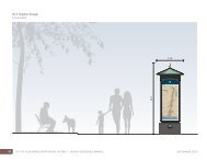
Figure 7-1: Elevated Walkway at <strong>Waterfront</strong> Park (View 1)......................................................7-3<br />
Figure 7-2: Elevated Walkway at <strong>Waterfront</strong> Park (View 2)......................................................7-4<br />
Figure 7-3: Elevated Walkway at Park South <strong>of</strong> Parking Lot on Strand Street...........................7-5<br />
Figure 7-4: 10-year <strong>Flood</strong> Inundation Before and After Elevated Pedestrian Walkway.............7-6<br />
Figure 7-5: Structures Protected by Elevated Walkway .............................................................7-7<br />
Figure 7-6: <strong>Flood</strong>wall behind Torpedo Factory........................................................................7-10<br />
Figure 7-7: <strong>Flood</strong>wall in Front <strong>of</strong> Chart House........................................................................7-11<br />
28-JUL-10\\ iv