

Celbridge Local Area Plan 2010 (pdf) - Kildare.ie
Celbridge Local Area Plan 2010 (pdf) - Kildare.ie
Celbridge Local Area Plan 2010 (pdf) - Kildare.ie

You also want an ePaper? Increase the reach of your titles
YUMPU automatically turns print PDFs into web optimized ePapers that Google loves.
52<br />
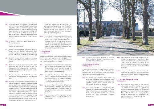
NH 7 To preserve v<strong>ie</strong>ws and prospects from the bridge<br />
over the River Liffey, upstream and downstream and to<br />
ensure that further development along either of the<br />
water systems does not affect the quality of either the<br />
scenic v<strong>ie</strong>wpoint or the waterways amenity. New<br />
development adjacent to the riverside amenity area<br />
shall be restricted where such development could<br />
present a negative visual effect or disrupt the vistas<br />
available.<br />
NH 8 To conserve and protect the natural habitats in the<br />
River Liffey systems<br />
<strong>Plan</strong>ning applications must;<br />
(i) Identify all ecological habitats and corridors which are<br />
present on the proposed development lands<br />
(including hedgerows and masonry stonewalls) that<br />
are likely to be affected by the development proposal.<br />
(ii) Identify any losses to these habitats and corridors,<br />
which would result if the application in question was<br />
granted.<br />
(iii) Show that such losses would be fully offset if the<br />
application was to be granted through the<br />
replacement of the relevant corridors, with corridors<br />
composed of similar spec<strong>ie</strong>s prior to any losses to the<br />
existing corridors.<br />
(iv) Show that habitat loss will either be offset should the<br />
application be granted or is not locally important to the<br />
area.<br />
NH 9 A suitable buffer zone will be maintained between all<br />
water bod<strong>ie</strong>s and any development. The extent of the<br />
riparian buffer zone should be determined in<br />
consultation with a qualif<strong>ie</strong>d ecologist. In all instances<br />
however a buffer of 2.5 metres of vegetation shall be<br />
retained along the riverbank to mitigate against<br />
pollution risks, reduce flooding potential and maintain<br />
habitat. In the event of lighting being proposed along<br />
river or canal corridors an Ecological Impact<br />
Assessment (and where necessary an Appropriate<br />
Assessment) including bat and otter survey shall be<br />
conducted by specialists. The recommendations of<br />
the specialist stud<strong>ie</strong>s shall be implemented. No<br />
lighting will be installed without prior consultation<br />
with NPWS and shall be in line with advances in<br />
knowledge into the impact of lighting on bats and<br />
other spec<strong>ie</strong>s and also to reflect advances in<br />
technology in the lighting industry.<br />
NH 10 In the event of a proposed development impacting<br />
on a site known to be a breeding or resting site of<br />
spec<strong>ie</strong>s listed in the Habitats Regulations a<br />
derogation license may be required. Applications for<br />
a derogation license should be made in writing,<br />
including survey results and proposed mitigation<br />
measures, to the Spec<strong>ie</strong>s and Regulations Unit,<br />
the National Parks and Wildlife Service.<br />
12.3 Built Heritage<br />
12. 3.1 Objectives<br />
In addition to the polic<strong>ie</strong>s of the Council outlined in Chapter<br />
17 of the <strong>Kildare</strong> County Development <strong>Plan</strong> (2005-2011) or the<br />
relevant chapter of any subsequent County Development<br />
<strong>Plan</strong>, it shall be an objective of the Council:<br />
BH 1 To promote the retention of original or early building<br />
fabric including timber sash windows, stonework,<br />
brickwork, joinery, render and slate. Likewise, the<br />
Council will encourage the re-instatement of<br />
historically correct traditional features.<br />
BH 2 To resist the demolition of vernacular architecture of<br />
historical, cultural and aesthetic merit, which make a<br />
positive contribution to the character, appearance<br />
and quality of the local streetscape and the<br />
sustainable development of <strong>Celbridge</strong>.<br />
BH 3 To assist owners of structures of particular<br />
significance within <strong>Celbridge</strong> in their maintenance<br />
and repair through advice and grant aid under the<br />
Building Conservation Grants scheme operated by<br />
the DoEHLG.<br />
BH 4 To protect those built heritage items as listed<br />
in Table 5 and shown on Maps 2a and 2b of this<br />
<strong>Local</strong> <strong>Area</strong> <strong>Plan</strong>.<br />
BH 5 To protect and preserve the v<strong>ie</strong>ws to and from<br />
those items listed in Table 5 and shown on Maps<br />
2a and 2b of this <strong>Local</strong> <strong>Area</strong> <strong>Plan</strong>.<br />
12. 4 Archaeological Heritage<br />
12. 4.1 Objectives<br />
In addition to the polic<strong>ie</strong>s of the Council outlined in Chapter<br />
17 of the <strong>Kildare</strong> County Development <strong>Plan</strong> (2005-2011) or the<br />
relevant chapter of any subsequent County Development<br />
<strong>Plan</strong>, it shall be an objective of the Council:<br />
AH 1 To protect and preserve those items of<br />
archaeological interest as listed in Table 4 and shown<br />
on Map 1 from inappropriate development that would<br />
adversely effect and/or detract from the<br />
interpretation and setting of these sites.<br />
AH 2 To seek the protection of burial grounds within<br />
<strong>Celbridge</strong> in co-operation with agenc<strong>ie</strong>s such as the<br />
Office of Public Works and the National Monuments<br />
Section of the Department of the Environment,<br />
Heritage and <strong>Local</strong> Government (DoEHLG),<br />
as appropriate.<br />
AH 3 To ensure that an archaeological assessment of any<br />
development in close proximity to or likely to impact<br />
on those sites listed in Table 4 and shown on Map 1, is<br />
carr<strong>ie</strong>d out by an archaeologist licensed by the<br />
DOEHLG. Future investigations of such sites should be<br />
carr<strong>ie</strong>d out in accordance with recommendations from<br />
the DOEHLG.<br />
AH 4 To require all developments involving the<br />
construction of roads to have regard to the National<br />
Roads Authority’s (NRA) guidelines on archaeological<br />
assessments.<br />
12.5 Zone of Archaeological Potential<br />
12.5.1 Objectives<br />
ZAP 1 The Council will have regard to the Zone of<br />
Archaeological potential in <strong>Celbridge</strong> when dealing<br />
with planning applications for development and<br />
public sector development including works carr<strong>ie</strong>d out<br />
by <strong>Kildare</strong> County Council. This area is identif<strong>ie</strong>d on<br />
Map 1. Where permission for such a proposal is<br />
granted, the applicant shall have due regard to the<br />
recommendations of the Heritage and <strong>Plan</strong>ning<br />
Division of the DoEHLG.<br />
53


