

Celbridge Local Area Plan 2010 (pdf) - Kildare.ie
Celbridge Local Area Plan 2010 (pdf) - Kildare.ie
Celbridge Local Area Plan 2010 (pdf) - Kildare.ie

Create successful ePaper yourself
Turn your PDF publications into a flip-book with our unique Google optimized e-Paper software.
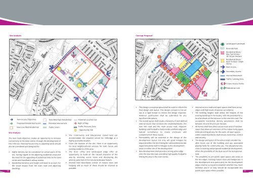
Site Analysis Concept Proposal<br />
New Access Objectives<br />
New Med/high Residential Potential <strong>Local</strong> Service<br />
Proposed Residential Access Potential Internal Link<br />
Right of Way<br />
New Low/Med Residential<br />
Site Analysis<br />
Public Green<br />
Traffic Pressure Zone<br />
Opportunity Site<br />
The new roads objective creates an opportunity to increase<br />
connectivity to the town centre, through the development of<br />
this infill site. Potential future links to adjoining lands should<br />
also be considered and designed for.<br />
• Higher density can be considered on certain parts of the<br />
site, having regard to the adjoining residential areas and<br />
the need for the upgrading of pedestrian links to the town<br />
centre and Hazelhatch railway station.<br />
• Residential densit<strong>ie</strong>s and height will need to account for<br />
the visual impact from the main road and adjoining<br />
dwellings.<br />
68<br />
• The ‘Community and Educational’ zoned land can<br />
accommodate the required school for <strong>Celbridge</strong> at a<br />
highly accessible location.<br />
• Given the location of the site, there is an opportunity<br />
for local neighbourhood services for both future and<br />
existing residents of the area.<br />
• The River Liffey and landscaped edge offer an<br />
opportunity to build on the natural character of the<br />
area by retaining scenic v<strong>ie</strong>ws and developing the<br />
amenity potential of this natural landscape feature.<br />
• Internal f<strong>ie</strong>ld boundar<strong>ie</strong>s consist of mature trees and<br />
hedging and as much of these should be retained as<br />
possible.<br />
• This design concept proposal shall be used to inform the<br />
final design and layout. This design concept is not set<br />
out in a rigid format to restrict the design response.<br />
However justification shall be submitted for any<br />
significant deviations.<br />
• The overall layout shall create a h<strong>ie</strong>rarchy of well-defined<br />
internal routes that connects the residential blocks, the<br />
new link road and the main access road. Adjacent<br />
buildings and footpaths shall provide a definite edge and<br />
natural surveillance to create enclosure and<br />
containment of these routes.<br />
• Permeability will be essential in the design of the<br />
development layout not only will good linkages be<br />
required within the site linking the various elements but<br />
regard should be had for linkages to the development<br />
areas on either site of the development.<br />
• New development shall provide a strong active edge<br />
onto the new link road, providing high quality footpaths<br />
linking the area to the town centre.<br />
Landscaped Landmark<br />
Riverside Park<br />
Residential Block/<br />
Max Two Storey/<br />
30–50 per Hectare<br />
Residential Block/<br />
Back To Back/ Single<br />
Storey<br />
Main Access<br />
Secondary Access<br />
Internal Movement<br />
Traffic Calming Zone<br />
Future Access Points<br />
Pedesterian Link<br />
• Internal access roads and open spaces shall have active<br />
edges with high levels of passive surveillance.<br />
• The building heights shall reflect the heights of the<br />
existing buildings in the locality, with the potential for a<br />
local landmark at the entrance to the new link road. The<br />
acceptable residential density parameters shall be<br />
between 30 and 50 units per hectare.<br />
• All homes shall have direct access to an area of outdoor<br />
space that allows an extension of the indoor living space,<br />
while providing privacy for the users. All open spaces<br />
within residential blocks shall ensure ownership, control<br />
and security.<br />
• The design and layout of the school shall consider the<br />
after hours use of the building and any associated<br />
playing f<strong>ie</strong>lds for community use. The educational site,<br />
close to existing and proposed residential development,<br />
offers the possibility of the dual use of the recreational<br />
land.<br />
• The possibility to join public open spaces also exists at<br />
the site edges. Existing mature trees and hedgerows in<br />
the development area particularly on the development<br />
edges shall be surveyed to establish whether they merit<br />
retention and if so they should be incorporated into<br />
public open space where possible.<br />
69


