

Celbridge Local Area Plan 2010 (pdf) - Kildare.ie
Celbridge Local Area Plan 2010 (pdf) - Kildare.ie
Celbridge Local Area Plan 2010 (pdf) - Kildare.ie

You also want an ePaper? Increase the reach of your titles
YUMPU automatically turns print PDFs into web optimized ePapers that Google loves.
72<br />
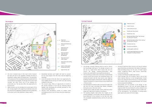
Site Analysis<br />
• The site is located close to the town centre however<br />
the links will have to be upgraded. Similarly the links to<br />
Hazelhatch railway station are paramount. The possibility<br />
of the dual use of the recreational land associated with the<br />
school shall be investigated. The design of the school shall<br />
consider the after hours use of the building for<br />
community use. The site also offers the opportunity for<br />
local services.<br />
• Higher density can be considered on certain parts of the<br />
site, having regard to the adjoining residential areas and<br />
the need for the upgrading of pedestrian and cycling links<br />
to the town centre and Hazelhatch railway station.<br />
Potential<br />
Vehicular Access<br />
Potential Pedestrian<br />
Access<br />
Potential Low/<br />
Med Density<br />
Residential<br />
Potential Med/<br />
High Density<br />
Residential<br />
Potential Green<br />
Open Space<br />
Potential Community<br />
Facilit<strong>ie</strong>s<br />
Green Landscaped<br />
Pedestrian Route<br />
Opportunity Site<br />
• Residential densit<strong>ie</strong>s and height will need to account<br />
for the visual impact from the main road and adjoining<br />
dwellings.<br />
• Given the location of the site, there is an opportunity for<br />
local neighbourhood services for both new and existing<br />
residents of the area.<br />
• The stream edge offers an opportunity to build on<br />
the natural character of the area by retaining natural<br />
habitats and developing the amenity potential of this<br />
natural landscape feature.<br />
• Internal f<strong>ie</strong>ld boundar<strong>ie</strong>s consist of mature trees<br />
and hedging and as much of these should be retained as<br />
possible.<br />
Concept Proposal<br />
• This design concept proposal shall be used to inform<br />
the final design and layout. This design concept is not<br />
set out as a rigid format which would only serve to<br />
restrict the design response.Justification shall<br />
however be submitted for any significant deviations.<br />
• The overall layout shall create a h<strong>ie</strong>rarchy of well-defined<br />
internal routes that connect the residential blocks, the<br />
institutional lands and the main access road. Adjacent<br />
buildings and footpaths shall provide a definite edge and<br />
natural surveillance to create enclosure and containment<br />
of these routes.<br />
• New development shall provide a strong active edge onto<br />
the new link road, providing high quality footpaths<br />
linking the area to the town centre.<br />
• Internal access roads and open spaces shall have active<br />
edges with high levels of passive surveillance.<br />
• The building heights shall reflect the heights of the<br />
existing buildings in the locality, with the potential for a<br />
local landmark at the entrance to the new link road.<br />
The acceptable residential density shall be 30 units per<br />
hectare.<br />
Internal Access<br />
Future Access<br />
Internal Movement<br />
Distributor Movement<br />
Pedestrian Link<br />
Residential Block/Max Two-storey/<br />
30 units per Hectare<br />
Residential Block/Max Three-storey/<br />
30 units per Hectare<br />
Institutional Use<br />
Structure Landmark<br />
Landscaped Landmark<br />
Landscaped Walking Route with<br />
Adequate Building Setback<br />
• All homes shall have direct access to an area of outdoor<br />
space that allows an extension of the indoor living space,<br />
while providing privacy for the users. All open spaces<br />
within residential blocks shall ensure ownership,<br />
control and security.<br />
• Location and design of public open spaces.<br />
• Good frontage onto the Shinkeen road is vital all the<br />
while making reference to the Donaghcumper stream<br />
which runs along the front of the site. An amenity buffer<br />
of 10 metres shall be incorporated between the stream<br />
and any proposed buildings.<br />
• Permeability will be essential in the design of the<br />
development layout. Not only will good linkages be<br />
required within the site linking the various elements but<br />
regard should be had for linkages to areas on either site<br />
of the development. The possibility of joining public<br />
open spaces also exists at the site edges.<br />
73


