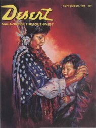
the magazine y - Desert Magazine of the Southwest
the magazine y - Desert Magazine of the Southwest
the magazine y - Desert Magazine of the Southwest

You also want an ePaper? Increase the reach of your titles
YUMPU automatically turns print PDFs into web optimized ePapers that Google loves.
1937 I met Byron Davies, a young man<br />
who had prospected in <strong>the</strong> vicinity <strong>of</strong><br />
Cane creek. He told me he had seen steps<br />
cut in <strong>the</strong> rock in a small canyon a mile<br />
below <strong>the</strong> supposed crossing. This seemed<br />
such a good clue that within a few days<br />
Davies, Kelly and I were headed upstream<br />
from Lee's ferry in a boat equipped<br />
with outboard motor, to check <strong>the</strong>se<br />
reported steps with Escalante's journal.<br />
With a very low stage <strong>of</strong> water and<br />
an underpowered motor we had great<br />
difficulty in negotiating <strong>the</strong> 40 miles to<br />
Cane creek, our destination. We finally<br />
arrived at noon <strong>of</strong> <strong>the</strong> third day, and<br />
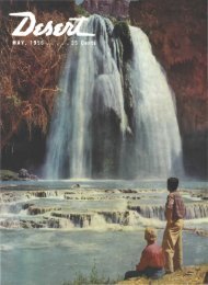
DR. RUSSELL G. FRAZIER<br />
Photograph taken at Lee's Ferry<br />
while with <strong>the</strong> Julius F. Stone expedition<br />
in 193S.<br />
immediately set out, in <strong>the</strong> broiling sun,<br />
to locate <strong>the</strong> little canyon seen by Davies.<br />
We found it about a mile south <strong>of</strong> Cane<br />
creek. It checked in every particular with<br />
Escalante's description. After some scouting<br />
we located a place where it seemed<br />
possible to get horses down from <strong>the</strong><br />
plateau above, and following this dim<br />
trail we soon discovered old wea<strong>the</strong>red<br />
steps cut in <strong>the</strong> rock, <strong>the</strong> same that Davies<br />
had seen previously. Our shouts, echoing<br />
down <strong>the</strong> narrow canyon, announced<br />
our enthusiastic belief that we had discovered<br />
<strong>the</strong> actual steps cut in 1776 by<br />
Escalante's party. We followed <strong>the</strong> little<br />
canyon down to <strong>the</strong> river and <strong>the</strong>re found<br />
and photographed <strong>the</strong> actual ford used<br />
by that first party <strong>of</strong> white men to make<br />
a crossing <strong>of</strong> <strong>the</strong> Colorado river. Esca-<br />
lante's description was so accurate that<br />
<strong>the</strong>re could be no mistake.<br />
In climbing back out <strong>of</strong> <strong>the</strong> canyon,<br />
however, we found ano<strong>the</strong>r series <strong>of</strong> ancient<br />
steps cut in <strong>the</strong> rock, making two<br />
series, one with 12 steps and one with<br />
25. This did not check with <strong>the</strong> statement<br />
that <strong>the</strong> steps were "about three<br />
yards or a little less." After studying <strong>the</strong><br />
matter for some time we concluded that<br />
some <strong>of</strong> <strong>the</strong> old trading expeditions from<br />
Santa Fe which followed this old Spanish<br />
trail after Escalante had pioneered it,<br />
might have added to Escalante's original<br />
steps to aid in getting <strong>the</strong>ir pack trains<br />
out <strong>of</strong> <strong>the</strong> canyon. This seemed reasonable.<br />
This river trip was made in August.<br />
Unfortunately, <strong>the</strong> shutter <strong>of</strong> my camera<br />
was out <strong>of</strong> order, and all my pictures<br />
were blanks! So in October I organized<br />
ano<strong>the</strong>r party to visit <strong>the</strong> crossing and<br />
get photographs. This time we went in<br />
overland, from Cannonville, Utah, with<br />
a pack train, principally because I wanted<br />
a photograph <strong>of</strong> a horse coming down<br />
that tricky, wea<strong>the</strong>r-worn flight <strong>of</strong> steps.<br />
This time I took several cameras and<br />
photographed <strong>the</strong> historic trail in blackand-white<br />
and color.<br />
In 1938 I made ano<strong>the</strong>r river trip with<br />
Charles Kelly and o<strong>the</strong>rs as a member <strong>of</strong><br />
<strong>the</strong> Julius F. Stone expedition. On that<br />
occasion we erected a copper plaque at<br />
<strong>the</strong> mouth <strong>of</strong> <strong>the</strong> little side canyon containing<br />
<strong>the</strong> steps, naming it Padre creek<br />
in honor <strong>of</strong> <strong>the</strong> two priests. This was my<br />
fourth visit to <strong>the</strong> crossing.<br />
In <strong>the</strong> spring <strong>of</strong> 1939 Byron Davies,<br />
our guide on <strong>the</strong> 1937 expedition, again<br />
visited <strong>the</strong> crossing with P. W. Tompkms<br />
<strong>of</strong> San Francisco, well known explorer<br />
<strong>of</strong> southwestern deserts. On that<br />
trip Davies brought back a photograph <strong>of</strong><br />
what appeared to be a badly wea<strong>the</strong>red<br />
inscription left by Escalante on <strong>the</strong> walls<br />
<strong>of</strong> Padre canyon. Knowing that any such<br />
inscription would be <strong>of</strong> <strong>the</strong> utmost importance<br />
to historians, I immediately organized<br />
ano<strong>the</strong>r overland expedition to<br />
photograph and translate <strong>the</strong> inscription<br />
if possible. I was again accompanied by<br />
Byron Davies, his bro<strong>the</strong>r Ammon, and<br />
my 11-year-old son John Russell. It was<br />
<strong>the</strong> boy's first real desert expedition, but<br />
he stood <strong>the</strong> experience <strong>of</strong> dry camps, a<br />
hard bed and long days in <strong>the</strong> saddle like<br />
a veteran.<br />
On this trip we planned not only to<br />
visit <strong>the</strong> crossing but to strike <strong>the</strong> trail<br />
below and follow it to <strong>the</strong> ford, checking<br />
every landmark with <strong>the</strong> journal so carefully<br />
kept by that first traveler. We started<br />
from <strong>the</strong> old abandoned Mormon<br />
town <strong>of</strong> Pahrea and struck Escalante's<br />
trail where it crossed Wah-weep creek.<br />
We were <strong>the</strong> first, since 1776, to retrace<br />
that section <strong>of</strong> Utah's oldest recorded<br />
trail and check <strong>the</strong> landmarks<br />
with <strong>the</strong> old journal. Traveling north<br />
from Gunsight butte we reached <strong>the</strong><br />
steep south bank <strong>of</strong> Padre creek, <strong>the</strong>n<br />
turned west for about a mile in order<br />
to head <strong>the</strong> deep canyon and reach <strong>the</strong><br />
previously discovered steps leading down<br />
from <strong>the</strong> north wall. It occurred to me<br />
that this detour was not mentioned in<br />
<strong>the</strong> journal.<br />
Our little caravan cautiously worked<br />
its way down over <strong>the</strong> old trail, finding<br />
<strong>the</strong> ancient steps a necessity for horse<br />
travel. Without <strong>the</strong>m we could not have<br />
made <strong>the</strong> descent safely. Both <strong>the</strong> animals<br />
and ourselves were indeed grateful for<br />
<strong>the</strong> cool, clear little stream in <strong>the</strong> bottom<br />
<strong>of</strong> <strong>the</strong> canyon. We made camp <strong>the</strong>re,<br />
clearing out a space in <strong>the</strong> dense growth<br />
<strong>of</strong> cane grass, and cooked supper, intending<br />
to search for <strong>the</strong> ancient inscription<br />
next morning. In <strong>the</strong> cool <strong>of</strong> <strong>the</strong> evening<br />
we took a stroll down <strong>the</strong> narrow canyon<br />
<strong>of</strong> Padre creek toward <strong>the</strong> river. My<br />
young son and Ammon Davies were<br />
some distance ahead when I heard <strong>the</strong>m<br />
shouting. I hurried on, presuming <strong>the</strong>y<br />
had found <strong>the</strong> inscription. Instead, <strong>the</strong>y<br />
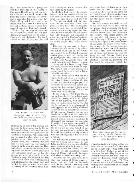
This copper plaque marking <strong>the</strong> actual<br />
Crossing oj <strong>the</strong> Fa<strong>the</strong>rs icas<br />
placed here in 1938 by <strong>the</strong> Julius F.<br />
Stone Expedition.<br />
pointed excitedly to a sloping wall on <strong>the</strong><br />
south side <strong>of</strong> <strong>the</strong> canyon in which were<br />
cut six ancient steps "three yards long<br />
or a little less," leading up out <strong>of</strong> <strong>the</strong><br />
canyon on that side. They had at last accidentally<br />
discovered <strong>the</strong> actual steps described<br />
by Escalante, which apparently<br />
have never been used since 1776. They<br />
are on <strong>the</strong> south side <strong>of</strong> Padre creek, answering<br />
every requirement <strong>of</strong> <strong>the</strong> record<br />
made at <strong>the</strong> time.<br />
The DESERT MAGAZINE