- Page 1 and 2: A spatial multi-risk hazard assessm
- Page 3 and 4: 4.2 VELD FIRE......................
- Page 5 and 6: LIST OF FIGURES Figure 1-1: Deaths
- Page 7 and 8: LIST OF TABLES Table 2-1: Classific
- Page 9 and 10: provides information to the Municip
- Page 11 and 12: In modern times people have come to
- Page 13 and 14: 1.1 PROBLEM DESCRIPTION It seems th
- Page 15 and 16: whether for further research on haz
- Page 17 and 18: • Demography Population data avai
- Page 19 and 20: Chapter 2: HAZARDS, RISK AND VULNER
- Page 21 and 22: 2.1.2 Hazard Assessment There are t
- Page 23 and 24: • Externalities from choices by o
- Page 25 and 26: It is also important to remember th
- Page 27 and 28: • Risks to an individual in a sma
- Page 29 and 30: 2.4 GEOGRAPHY IN HAZARD, RISK AND V
- Page 31 and 32: It is possible to profile the geogr
- Page 33 and 34: Unfortunately, because of the metho
- Page 35 and 36: Epidemics The slope of an area has
- Page 37 and 38: Human Induced/Environmental Homelan
- Page 39 and 40: Chapter 4: NATURAL HAZARDS. Develop
- Page 41 and 42: 4.1.1 Hazard Identification To iden
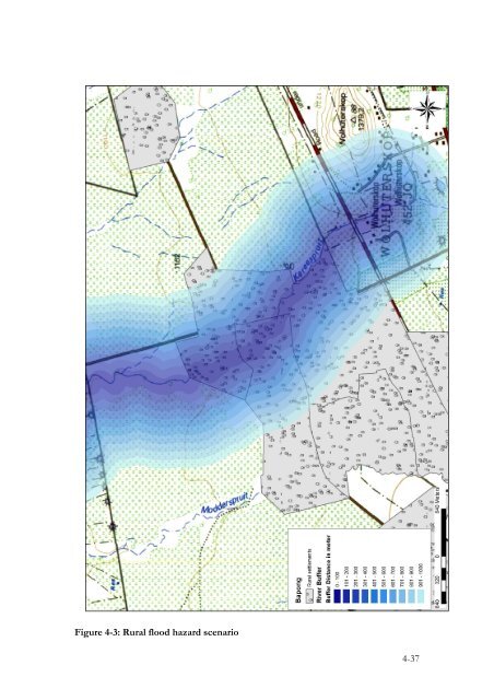
- Page 43 and 44: Table 4-1 indicates settlements and
- Page 45: Figure 4-2: Urban flood hazard scen
- Page 49 and 50: Figure 4-5: Vaalkop and Rooikoppies
- Page 51 and 52: • Klipvoor dam failure scenario.
- Page 53 and 54: 4.2 VELD FIRE Periodic fires are na
- Page 55 and 56: percent of local veld fires reporte
- Page 57 and 58: Madibeng therefore has a relatively
- Page 59 and 60: This report provides an account of
- Page 61 and 62: Figure 4-9: Madibeng fuel categorie
- Page 63 and 64: Figure 4-10: Fire hazard map for Ma
- Page 65 and 66: However, there are areas around the
- Page 67 and 68: Fire protection associations should
- Page 69 and 70: dry land areas, because for them dr
- Page 71 and 72: Drought can be defined in several d
- Page 73 and 74: The annual average rainfall for Mad
- Page 75 and 76: Figure 4-13: Percentage of clay con
- Page 77 and 78: The drought risk assessment was the
- Page 79 and 80: 4.3.3 Vulnerability Assessment. Soc
- Page 81 and 82: Figure 4-17 indicates that a large
- Page 83 and 84: Improved remote sensing from satell
- Page 85 and 86: Figure 4-19: Madibeng dolomite geol
- Page 87 and 88: characterised by good housing, the
- Page 89 and 90: Traditional land use practices that
- Page 91 and 92: The unequal distribution of wealth
- Page 93 and 94: Figure 5-2: Population 5-19 year ol
- Page 95 and 96: Figure 5-3: Madibeng employment rat
- Page 97 and 98:
Figure 5-4: Poor households and env
- Page 99 and 100:
Figure 5-5: Percentage male populat
- Page 101 and 102:
5.1.2.1 Malnutrition and Starvation
- Page 103 and 104:
In arid regions, drought can leave
- Page 105 and 106:
5.1.3.1 Income level approach Incom
- Page 107 and 108:
esources. The quality and quantity
- Page 109 and 110:
Figure 5-7 shows the distribution o
- Page 111 and 112:
However, there are serious safety a
- Page 113 and 114:
The central and northern areas do n
- Page 115 and 116:
In South Africa only one percent of
- Page 117 and 118:
major economical setbacks that has
- Page 119 and 120:
5.2 HAZARDOUS MATERIALS As was disc
- Page 121 and 122:
The following hazardous locations a
- Page 123 and 124:
These are only industries identifie
- Page 125 and 126:
Figure 5-13: Necsa 5-116
- Page 127 and 128:
5.2.2 Hazmat Risk and Vulnerability
- Page 129 and 130:
The high concentration of mining ac
- Page 131 and 132:
Figure 5-16: Brits industrial area
- Page 133 and 134:
Figure 5-18: Necsa risk area
- Page 135 and 136:
Bapong-Skoolplaas Majakaneng Madiny
- Page 137 and 138:
Figure 5-20: Hazardous material tra
- Page 139 and 140:
5.2.3 Summary Although hazardous ma
- Page 141 and 142:
6.1 GIS FOR DISASTER MANAGEMENT IN
- Page 143 and 144:
and risk assessments in place, it w
- Page 145 and 146:
It would not necessarily be the sol
- Page 147 and 148:
6.2.4 Geological Hazards Very littl
- Page 149 and 150:
6.3 SUMMARY GIS has the capability
- Page 151 and 152:
Blong, R., Murty, T., Papadopoulos,
- Page 153 and 154:
Greene, R.W., 2002: Confronting Cat
- Page 155 and 156:
RSA., 1998: Poverty and Inequality
- Page 157 and 158:
Zschau, J. and, Küppers, A.N., 200
- Page 159 and 160:
# Please indicate general location
- Page 161 and 162:
3 - 4 - 4. Dangerous: 3.4a a) Plant
- Page 163 and 164:
The following data will be needed i
- Page 165:
Filename: Madibeng_multiple_hazard9