Eng~Saldanha Wind Farm BID Eng_Final 02022011.pdf - Aurecon ...
Eng~Saldanha Wind Farm BID Eng_Final 02022011.pdf - Aurecon ...
Eng~Saldanha Wind Farm BID Eng_Final 02022011.pdf - Aurecon ...

Create successful ePaper yourself
Turn your PDF publications into a flip-book with our unique Google optimized e-Paper software.
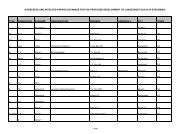
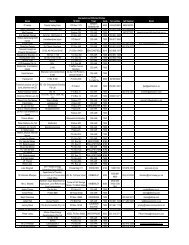
LOCATION AND AFFECTED ENVIRONMENT<br />
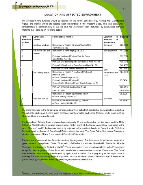
The proposed wind turbines would be located on the farms Schuitjes Klip, Honing Klip, Zandfontein,<br />
Kliprug and Holvlei which are located near Vredenburg in the Western Cape. The total area under<br />
consideration is approximately 6 000 ha and has previously been disturbed by agricultural activities<br />
(Refer to the Table below for more detail).<br />
<strong>Farm</strong><br />
Reference<br />
on Map<br />
Landowner<br />
Details<br />
<strong>Farm</strong>/Portion Number Location in<br />
Relation to<br />
Vredenburg<br />
The major landuse in the larger area consists primarily of industrial, residential and agriculture activities.<br />
Agricultural activities on the five farms comprise mainly of cattle and sheep farming, while crops such as<br />
wheat and lupins are also farmed.<br />
The Langebaan Airforce Base is situated approximately 25 km south-east of the five farms and the Mittal<br />
Saldanha Steel Smelter is located approximately 10 km south of the farms. Jacobsbaai is situated to the<br />
west of <strong>Farm</strong>s 1 and 2. Trekoskraal is directly adjacent to the southern border of <strong>Farm</strong> 3, while St Helena<br />
Bay is situated north-east of <strong>Farm</strong> 5 and Paternoster to the west. The Cape Columbine Nature Reserve is<br />
situated north-west of <strong>Farm</strong> 3 and south of <strong>Farm</strong> 5 in Paternoster.<br />
The landscape across all five farms is relatively homogenous. The five farms lie within four vegetation<br />
types namely; Langebaan Dune Strandveld, Saldanha Limestone Strandveld, Saldanha Granite<br />
Strandveld and Saldanha Flats Strandveld 1 . These vegetation types are all considered to be Endangered<br />
except for the Langebaan Dune Strandveld which has a conservation status of Vulnerable. The farms<br />
have however been heavily transformed by agricultural activities. The topography of the larger area is<br />
relatively flat with undulating fields and granite outcrops scattered across the landscape. A substantive<br />
granite outcrop, Klipheuwel with indigenous vegetation occurs on <strong>Farm</strong> 4.<br />
1 Mucina, L. and Rutherford, M.C.(eds). 2006. The Vegetation of South Africa, Lesotho and Swaziland. Strelitzia 19<br />
3<br />
Size(Ha)<br />
1 Mr Klaas Loubser Remainder of Portion 1 (Holvlei West) of the<br />
<strong>Farm</strong> Holvlei 120<br />
5km west 563.4056<br />
2 Mr Reon van der<br />
Merwe<br />
Remainder of <strong>Farm</strong> Kliprug No. 282 5km southwest 441.2586<br />
3<br />
Portion 4 (portion of Portion 1) of the <strong>Farm</strong><br />
Zandfontein No. 105<br />
933.8326<br />
Portion 6 (Hartzenberg) of <strong>Farm</strong> Besters Kraal No. 38 428.2746<br />
5<br />
4<br />
Mr Tommy Bester<br />
Mr Klaas van Zyl<br />
Portion 5 (Noodhulp) of <strong>Farm</strong> Besters Kraal No. 38 547.4695<br />
Portion 8 of <strong>Farm</strong> Besters Kraal No. 38 60.0598<br />
Remainder of Portion 7 (portion of Portion 2)<br />
(Morkels Dam)<br />
of <strong>Farm</strong> Davids Fontyn No 18<br />
Portion 9 (portion of Portion 7)<br />
(Annex Kaffer Skuitje) of <strong>Farm</strong> Davids Fontyn No 18<br />
5km<br />
northwest/10km<br />
north<br />
427.8549<br />
85.6404<br />
Portion 1 of <strong>Farm</strong> Schuitjies Klip No 22 860.8147<br />
<strong>Farm</strong> No 1076<br />
Remainder of Portion 2 (Willems Fontein )<br />
of <strong>Farm</strong> Honing Klip No. 101<br />
Portion 19 (portion of Portion 1)(Driehoek)<br />
of <strong>Farm</strong> Honing Klip No. 101<br />
2km east<br />
1474.2558<br />
30.3226<br />
70.2356
![CRR IV FEIR ~ 26042010 [FINAL].pdf - Environmental Projects](https://img.yumpu.com/21973020/1/184x260/crr-iv-feir-26042010-finalpdf-environmental-projects.jpg?quality=85)