Aretz et al_2011.pdf - ORBi - Université de Liège
Aretz et al_2011.pdf - ORBi - Université de Liège
Aretz et al_2011.pdf - ORBi - Université de Liège

You also want an ePaper? Increase the reach of your titles
YUMPU automatically turns print PDFs into web optimized ePapers that Google loves.
_________________________________________________________________________________________________________<br />
Kölner Forum Geol. P<strong>al</strong>äont., 19 (2011)<br />
M. ARETZ, S. DELCULÉE, J. DENAYER & E. POTY (Eds.)<br />
Abstracts, 11th Symposium on Fossil Cnidaria and Sponges, <strong>Liège</strong>, August 19-29, 2011<br />
_________________________________________________________________________________________________________<br />
Origin of the Great Barrier Reef<br />
John S. JELL<br />
University of Queensland; School of Earth Sciences, University of Queensland, St Lucia, Qld 4120,<br />
Austr<strong>al</strong>ia; j.jell@bigpond.com<br />
The Great Barrier Reef (GBR) is by far the largest reef province of today’s tropic<strong>al</strong> seas and is World<br />
Heritage listed. It consists of more than 3,500 reefs scattered over a quarter of a million square kilom<strong>et</strong>res<br />
off the east coast of Queensland, str<strong>et</strong>ching 2,300 km from Lady Elliot Island in the south to Torres Strait in<br />
the north, and varying from 350 km wi<strong>de</strong> off Rockhampton to 30 km wi<strong>de</strong> off Cooktown. Less than ten<br />
percent of the province is actu<strong>al</strong> cor<strong>al</strong> reef. The reefs are very variable in size, shape and topography, and<br />
appear randomly distributed. Thus any explanation of the origin of the GBR must explain why such a great<br />
reef province is <strong>de</strong>veloped on the northeast coast of the Austr<strong>al</strong>ian continent, what d<strong>et</strong>ermines the reefs’<br />
morphology, and what controls their distribution. We are part of the way to un<strong>de</strong>rstanding these and this<br />
contribution gives an historic<strong>al</strong> perspective of our un<strong>de</strong>rstanding of these to date.<br />
Although probably sighted by early Portuguese, Spanish, Dutch and French navigators before 1770, it<br />
was Captain James Cook’s <strong>de</strong>scription and charts of the reef in his journ<strong>al</strong> of his voyage across the southern<br />
oceans that affor<strong>de</strong>d the fascination with the GBR that followed. Cook saw it as a navigation<strong>al</strong> hazard<br />
<strong>de</strong>scribing it as: ’a w<strong>al</strong>l of Cor<strong>al</strong> Rock rising <strong>al</strong>l most perpendicular out of the unfathomable Ocean . . . the<br />
large waves of vast Ocean me<strong>et</strong>ing with so sud<strong>de</strong>n a resistance make a most terrible surf breaking<br />
mountains high’. With s<strong>et</strong>tlement of Austr<strong>al</strong>ia in 1788, charting of the coastline became essenti<strong>al</strong> and this<br />
inclu<strong>de</strong>d the reefs of the GBR; many of these expeditions carried natur<strong>al</strong>ists. The first geologists to visit the<br />
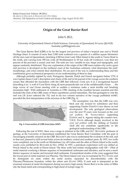
reef was J.B. JUKES onboard the ‘Fly’ and in his two volume narrative of the voyage published in1847,<br />
provi<strong>de</strong>d the first interpr<strong>et</strong>ation of the structure of the GBR (Fig. 1).<br />
The assumption was that the GBR was very<br />
thick and old, formed by subsi<strong>de</strong>nce and thus<br />
supporting Charles DARWIN’S new theory on reef<br />
<strong>de</strong>velopment. The only geologic<strong>al</strong> observations<br />
over the next 70 years were focused on the cor<strong>al</strong><br />
reef problem, W. SAVILLE-KENT supporting<br />
DARWIN and A. Agassiz taking the counter-view.<br />
T.W.E. DAVID <strong>al</strong>though <strong>de</strong>eply involved in the<br />
Fig. 1: Cross-section of GBR from Jukes (1847)<br />
cor<strong>al</strong> reef problem with the drilling of Funifuti<br />
Atoll did not contribute significantly to the<br />
geologic<strong>al</strong> un<strong>de</strong>rstanding of the GBR.<br />
Following the end of WW1, there was a surge in int<strong>et</strong>rest in the GBR, and H.C. RICHARDS, professor of<br />
geology at the University of Queensland established the Great Barrier Reef Committee with the go<strong>al</strong> of<br />
encouraging scientific research on the GBR. RICHARD’S aim was to un<strong>de</strong>rstand the evolution of the reef, and<br />
to that end, planned to drill sever<strong>al</strong> holes across its northern, centr<strong>al</strong> and southern parts. By 1937, two wells<br />
were compl<strong>et</strong>ed, one in the north on Michaelmas Cay off Cairns and the other at Heron Island in the south;<br />
results were published by RICHARDS & HILL (1942). In 1957, a p<strong>et</strong>roleum exploration well was drilled on<br />
Wreck Island to the north of Heron Island. The three wells had similar stratigraphies with 100 – 150m of<br />
reef<strong>al</strong> materi<strong>al</strong> overlying a thinner sequence of foraminifer<strong>al</strong> carbonates and silicastics, and in turn a much<br />
thicker sequence of marine and terresri<strong>al</strong> shelf sediments. Foraminifer<strong>al</strong> studies of the cores suggested that<br />
the lowest part of reef<strong>al</strong> materi<strong>al</strong> was Pliocene. The Heron Island core was re-examined by P.G. FLOOD, and<br />
he distinguish six units within the reef<strong>al</strong> section, separated by disconformities with the<br />
Pliocene/Pleistocene boundary within the ol<strong>de</strong>st unit (FLOOD 1993). If each unit is interpr<strong>et</strong>ed as the<br />
erosion<strong>al</strong> remnant of reef<strong>al</strong> <strong>de</strong>velopment during successive high stands, Heron Reef is in the or<strong>de</strong>r of 500ka<br />
old, the bas<strong>al</strong> reef<strong>al</strong> unit corresponding to high stand of isotope stage 13.<br />
63