Salinity situation statement Tweed River and Gnowergerup Brook
Salinity situation statement Tweed River and Gnowergerup Brook
Salinity situation statement Tweed River and Gnowergerup Brook

You also want an ePaper? Increase the reach of your titles
YUMPU automatically turns print PDFs into web optimized ePapers that Google loves.
Water Resource Technical Series <strong>Salinity</strong> <strong>situation</strong> <strong>statement</strong>: <strong>Tweed</strong> <strong>River</strong> <strong>and</strong> <strong>Gnowergerup</strong> <strong>Brook</strong> WRT 41<br />
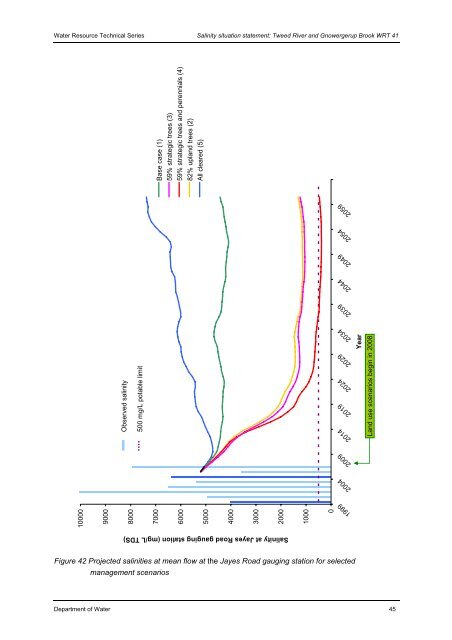
10000<br />
9000<br />
Observed salinity<br />
8000<br />
500 mg/L potable limit<br />
Base case (1)<br />
59% strategic trees (3)<br />
59% strategic trees <strong>and</strong> perennials (4)<br />
7000<br />
6000<br />
82% upl<strong>and</strong> trees (2)<br />
All cleared (5)<br />
5000<br />
Figure 42 Projected salinities at mean flow at the Jayes Road gauging station for selected<br />
management scenarios<br />
Department of Water 45<br />
4000<br />
3000<br />
2000<br />
<strong>Salinity</strong> at Jayes Road gauging station (mg/L TDS)<br />
1000<br />
0<br />
2059<br />
2054<br />
2049<br />
2044<br />
2039<br />
2034<br />
2029<br />
2024<br />
2019<br />
2014<br />
2009<br />
2004<br />
1999<br />
Year<br />
L<strong>and</strong> use scenarios begin in 2008