Numerical modelin of floating prefabricated vertical drains in layered ...
Numerical modelin of floating prefabricated vertical drains in layered ...
Numerical modelin of floating prefabricated vertical drains in layered ...

You also want an ePaper? Increase the reach of your titles
YUMPU automatically turns print PDFs into web optimized ePapers that Google loves.
I. IKHYA & H. F. SCHWEIGER: NUMERICAL MODELING OF FLOATING PREFABRICATED VERTICAL DRAINS IN LAYERED SOIL<br />
2 SITE DESCRIPTION AND<br />
GROUND CONDITION<br />
The Cirebon Power Plant site is located on the north<br />
coastal pla<strong>in</strong> <strong>of</strong> Java, near Kanci Village, which is<br />
approximately 20 kilometres to the south-east <strong>of</strong> Cirebon<br />
city and around 290 kilometres to the east <strong>of</strong> Jakarta<br />
city. The site is bounded by the Java Sea to the north,<br />
the Kanci River to the east, and the Waruduwur River to<br />
the west. The area <strong>of</strong> the s<strong>in</strong>gle-unit 660MW coal-fired<br />
power station covers around 50 hectares. The topography<br />
<strong>of</strong> the plant site comprises a relatively flat and<br />
low-ly<strong>in</strong>g area with an average elevation <strong>of</strong> around +0.5<br />
meters above mean sea level. The coast <strong>of</strong> the Cirebon<br />
area has a tidal range between 0.5 to 1.3 meters [12]. An<br />
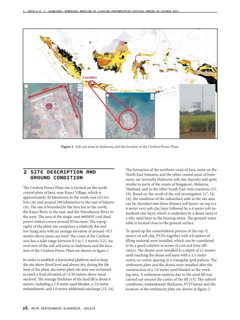
overview <strong>of</strong> the s<strong>of</strong>t soil areas <strong>in</strong> Indonesia and the location<br />
<strong>of</strong> the Cirebon Power Plant are shown <strong>in</strong> figure 1.<br />
In order to establish a horizontal platform and to keep<br />
the site above flood level and always dry dur<strong>in</strong>g the life<br />
time <strong>of</strong> the plant, the entire plant site area was reclaimed<br />
to reach a f<strong>in</strong>al elevation <strong>of</strong> +2.50 meters above mean<br />
sea level. The average thickness <strong>of</strong> the land fill is about 4<br />
meters, <strong>in</strong>clud<strong>in</strong>g a 1.0 meter sand blanket, a 2.0 meter<br />
embankment, and 1.0 meter additional surcharge [13, 14].<br />
26. ACTA GEOTECHNICA SLOVENICA, 2012/2<br />
Figure 1. S<strong>of</strong>t soil areas <strong>in</strong> Indonesia and the location <strong>of</strong> the Cirebon Power Plant.<br />
The formation <strong>of</strong> the northern coast <strong>of</strong> Java, some on the<br />
North East Sumatra, and the other coastal areas <strong>of</strong> Indonesia,<br />
are normally Holocene s<strong>of</strong>t clay deposits and quite<br />
similar to parts <strong>of</strong> the coasts <strong>of</strong> S<strong>in</strong>gapore, Malaysia,<br />
Thailand, and <strong>in</strong> the other South East Asia countries [15,<br />
16]. Based on the result <strong>of</strong> the soil <strong>in</strong>vestigation [17, 18,<br />
14], the condition <strong>of</strong> the subsurface soils <strong>in</strong> the site area<br />
can be classified <strong>in</strong>to three dist<strong>in</strong>ct soil layers: on top is a<br />
6 meter very s<strong>of</strong>t clay layer followed by a 6 meter s<strong>of</strong>t-tomedium<br />
clay layer, which is underla<strong>in</strong> by a dense sand or<br />
a silty sand layer as the bear<strong>in</strong>g strata. The ground-water<br />
table is located close to the ground surface.<br />
To speed up the consolidation process <strong>of</strong> the top 12<br />
meters <strong>of</strong> s<strong>of</strong>t clay, PVDs together with 4.0 meters <strong>of</strong><br />
fill<strong>in</strong>g material were <strong>in</strong>stalled, which can be considered<br />
to be a good solution <strong>in</strong> terms <strong>of</strong> cost and time efficiency.<br />
The <strong>dra<strong>in</strong>s</strong> were <strong>in</strong>stalled to a depth <strong>of</strong> 12 meters<br />
until reach<strong>in</strong>g the dense soil layer with a 1.5 meter<br />
centre-to-centre spac<strong>in</strong>g <strong>in</strong> a triangular grid pattern. The<br />
settlement plate and the <strong>dra<strong>in</strong>s</strong> were <strong>in</strong>stalled after the<br />
construction <strong>of</strong> a 1.0 meter sand blanket as the work<strong>in</strong>g<br />
area. A settlement analysis due to the areal fill was<br />
carried out around the centre <strong>of</strong> the fill [13]. The subsoil<br />
conditions, embankment thickness, PVD layout and the<br />
location <strong>of</strong> the settlement plate are shown <strong>in</strong> figure 2.