Urban Climate News - FAU
Urban Climate News - FAU
Urban Climate News - FAU

You also want an ePaper? Increase the reach of your titles
YUMPU automatically turns print PDFs into web optimized ePapers that Google loves.
<strong>Urban</strong> Projects 1<br />
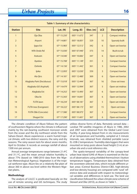
Table 1: Summary of site characteristics.<br />
Station Site Lat. (N) Long. (E) Elev. (m) LCZ Description<br />
1 Oja Oba 07 o 15.250’ 005 o 11.672’ 347 2 Compact midrise<br />
2 Airport 07 o 14.881’ 005 o 18.001’ 329 10 Sparsely built<br />
3 Ijapo Est 07 o 15.983’ 005 o 12.512’ 342 6 Open-set lowrise<br />
4 NTA Ondo Rd 07 o 15.030’ 005 o 07.940’ 373 14 Bush/scrub<br />
5 Aratusin 07 o 14.546’ 005 o 10.682’ 347 6 Open-set lowrise<br />
6 Ayedun 07 o 15.708’ 005 o 11.149’ 351 3 Compact lowrise<br />
7 Oshinle 07 o 14.156’ 005 o 11.442’ 361 3 Compact lowrise<br />
8 Ijoka 07 o 12.093’ 005 o 12.030’ 359 3 Compact lowrise<br />
9 Ala Qtrs 07 o 14.181’ 005 o 12.480’ 369 6 Open-set lowrise<br />
10 Alagbaka Park (Deciduous) 07 o 15.018’ 005 o 12.444’ 367 16 Close-set trees<br />
11 Alagbaka GO (Asphalt) 07 o 14.479’ 005 o 12.994’ 367 5 Open-set midrise<br />
12 Alagbaka Est 07 o 14.252’ 005 o 13.495’ 367 6 Open-set lowrise<br />
13 Oba ile 07 o 15.343’ 005 o 14.841’ 367 6 Open-set lowrise<br />
14 FUTA lawn 07 o 18.234’ 005 o 08.181’ 367 5 Open-set midrise<br />
15 FUTA tree (Evergreen) 07 o 18.222’ 005 o 08.173’ 367 15 Open-set trees<br />
16 FUTA Obk (Concrete) 07 o 17.586’ 005 o 08.975’ 367 3 Compact lowrise<br />
17 Shagari Est 07 o 17.290’ 005 o 11.601’ 367 6 Open-set lowrise<br />
The climatic condition of Akure follows the pattern<br />
of southwestern Nigeria where the climate is influenced<br />
mainly by the rain-bearing southwest monsoon winds<br />
from the ocean and the dry northwest winds from the<br />
Sahara Desert. Akure experiences a warm humid tropical<br />
climate, with two distinct seasons, the rainy and dry<br />
seasons. The rainy season lasts for about seven months,<br />
April to October. It records an average rainfall of about<br />
1500 mm per annum.<br />
Annual average temperatures range between 21.4 o C<br />
and 31.1 o C, and the mean annual relative humidity is<br />
about 77% (based on 1980-2010 data from the Nigerian<br />
Meteorological Agency). Vegetation is of the tropical<br />
rainforest type. Akure lies on a relatively flat plain of<br />
about 360 m above sea level within the Western Nigerian<br />
plains.<br />
Methodology<br />
The analysis of LULCC is predicated basically on the<br />
use of remote sensing and GIS techniques. The study<br />
utilizes diverse forms of data. Remotely sensed data −<br />
Landsat TM satellite imageries of Akure in 1986, 2002<br />
and 2007 were obtained from the Global Land Cover<br />
Facility. A year-long dataset from in situ measurements<br />
of air temperature and humidity, sampled at 5 minute<br />
intervals, was obtained from shielded portable Lascar<br />
EL-USB-2 temperature / humidity data loggers that were<br />
mounted on lamp posts above head height (3 m) at anurban<br />
site and a rural reference site.<br />
The spatio-temporal variability of the canopy-level<br />
urban heat island (UHI) of Akure is examined on the basis<br />
of observations using shielded thermochron i-button<br />
temperature loggers. Temperature data obtained from<br />
the seventeen selected sites, which include different urban<br />
areas (Central Business District-CBD, high-density<br />
and low-density housing) are compared with ‘rural’ reference<br />
data and analysed with respect to meteorological<br />
variables and differences in land use. The land use<br />
classification followed the urban climate zone scheme of<br />
Stewart and Oke (2010), as shown in Table 1.<br />
ISSUE NO. 46 DECEMBER 2012 INTERNATIONAL ASSOCIATION FOR URBAN CLIMATE