Urban Climate News - FAU
Urban Climate News - FAU
Urban Climate News - FAU

You also want an ePaper? Increase the reach of your titles
YUMPU automatically turns print PDFs into web optimized ePapers that Google loves.
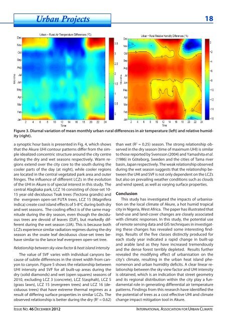
<strong>Urban</strong> Projects 1<br />
Figure 3. Diurnal variation of mean monthly urban-rural differences in air temperature (left) and relative humidity<br />
(right).<br />
a synoptic hour basis is presented in Fig. 4, which shows<br />
that the Akure UHI contour patterns differ from the simple<br />
idealized concentric structure around the city centre<br />
during the dry and wet seasons respectively. Warm regions<br />
extend over the city core to the south during the<br />
cooler parts of the day (at night), while cooler regions<br />
are located in the central vegetated park area and outer<br />
fringes. The influence of different LCZs in the evolution<br />
of the UHI in Akure is of special interest in this study. The<br />
central Alagbaka park, LCZ 16 consisting of close-set 10-<br />
15 year old deciduous Teak trees (Tectona grandis) and<br />
the evergreen open-set FUTA trees, LCZ 15 (Magnifera<br />
indica) create cool island effects of 5-8 o C during both dry<br />
and wet seasons. The cooling effect is of the same magnitude<br />
during the dry season, even though the deciduous<br />
trees are devoid of leaves (DJF), but markedly different<br />
during the wet season (JJA). This is because both<br />
LCZs experience similar radiation regimes during the dry<br />
season as the ovate leaf deciduous close-set trees behave<br />
similar to the lance leaf evergreen open-set tree.<br />
Relationship between sky view factor & heat island intensity<br />
The value of SVF varies with individual canyons because<br />
of subtle differences in the street width from canyon<br />
to canyon. Figure 5 shows the relationship between<br />
UHI intensity and SVF for all built-up areas during the<br />
dry (solid diamonds) and wet (open squares) seasons of<br />
2010, excluding LCZ 3 (concrete), LCZ 5(asphalt), LCZ 5<br />
(grass lawn), LCZ 15 (evergreen trees) and LCZ 16 (deciduous<br />
trees) that have extreme thermal regimes as a<br />
result of differing surface properties in similar LCZs. The<br />
observed relationship is better during the dry (R 2 = 0.62)<br />
than wet (R 2 = 0.25) season. The strong relationship observed<br />
in the dry season (time of maximum UHI) is similar<br />
to those reported by Svensson (2004) and Yamashita et al.<br />
(1986) in Göteborg, Sweden and the cities of Tama river<br />
basin, Japan respectively. The weak relationship observed<br />
during the wet season suggests that the relationship between<br />
the UHI and SVF is not only dependent on the LCZs<br />
but also on prevailing weather conditions such as clouds<br />
and wind speed, as well as varying surface properties.<br />
Conclusion<br />
This study has investigated the impacts of urbanisation<br />
on the local climate of Akure, a hot humid tropical<br />
city in Nigeria, West Africa. The paper has illustrated that<br />
land-use and land-cover changes are closely associated<br />
with climatic responses. In this study, the potential use<br />
of remote sensing data and GIS techniques in investigating<br />
these changes has revealed some interesting findings.<br />
Results of the five classes distinctly produced for<br />
each study year indicated a rapid change in built-up<br />
and arable land as they have increased tremendously<br />
and the dense forest terribly depleted. Results further<br />
revealed the modifying effect of urbanisation on the<br />
city’s climate, resulting in the urban heat island phenomenon<br />
and urban humidity deficits. A clear linear relationship<br />
between the sky view factor and UHI intensity<br />
is obtained, which is an indication that street geometry<br />
and its regional distribution within the city play a fundamental<br />
role in generating differential air temperature<br />
patterns. Findings from this research have identified the<br />
the potential of trees as a cost effective UHI and climate<br />
change impact mitigation tool in Akure.<br />
ISSUE NO. 46 DECEMBER 2012 INTERNATIONAL ASSOCIATION FOR URBAN CLIMATE