

Cranbourne East Precinct Structure Plan - Growth Areas Authority
Cranbourne East Precinct Structure Plan - Growth Areas Authority
Cranbourne East Precinct Structure Plan - Growth Areas Authority

You also want an ePaper? Increase the reach of your titles
YUMPU automatically turns print PDFs into web optimized ePapers that Google loves.
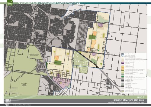
Scale: 1:20000m @ A3<br />
1:10000m @ A1<br />
Date: 2 May 2010<br />
Revision.: O<br />
0 200 400 600m<br />
ROYAL BOTANIC<br />
GARDENS<br />
CRANBOURNE<br />
CRANBOURNE<br />
RAIL STATION<br />
18 Part 2: Calculation of Contributions<br />
CRANBOURNE<br />
TOWN CENTRE<br />
CRANBOURNE RACECOURSE<br />
& RECREATION RESERVE<br />
NARRE WARREN - CRANBOURNE RD<br />
22<br />
23<br />
24<br />
25<br />
26<br />
27<br />
LINSELL BLVD<br />
4<br />
20<br />
29<br />
5<br />
21<br />
28<br />
3<br />
19<br />
30<br />
32<br />
18<br />
31<br />
SOUTH GIPPSLAND HWY<br />
BERWICK - CRANBOURNE RD<br />
6<br />
16<br />
17<br />
33<br />
7<br />
15<br />
14<br />
13<br />
35<br />
34<br />
8<br />
36B<br />
12<br />
2<br />
36A<br />
9<br />
10<br />
11<br />
37<br />
1<br />
BALLARTO RD<br />
CASEY FIELDS<br />
39<br />
38<br />
60<br />
61<br />
59B 58 57<br />
59A<br />
56 55<br />
40<br />
62<br />
42<br />
41<br />
65<br />
LINSELL BLVD<br />
43<br />
54<br />
45<br />
44<br />
64<br />
47<br />
46<br />
49<br />
48<br />
CLYDE - FIVE WAYS RD<br />
52<br />
51<br />
50<br />
53<br />
63<br />
BERWICK - CRANBOURNE RD<br />
PATTERSONS RD<br />
<strong>Precinct</strong> <strong>Structure</strong> <strong>Plan</strong> Area<br />
Urban <strong>Growth</strong> Boundary<br />
57 Property Reference Number<br />
Conventional Residential<br />
Medium Density Residential (preferred indicative locations)<br />
High Density Residential (preferred indicative locations)<br />
Local Town Centre (NAC)<br />
Local Centre<br />
Employment<br />
Community Facilities<br />
State Primary School (P6)<br />
Non-Government Education Facility (subject to permit)<br />
Unencumbered Active Open Space/Playing Fields<br />
Unencumbered Passive Open Space<br />
Waterway/Drainage<br />
Conservation Open Space<br />
Heritage Open Space<br />
Land to be Acquired by City of Casey for Casey Fields<br />
Existing Road Reserve (not allocated for development)<br />
Arterial Road - 6 Lane<br />
Arterial Road - 4 Lane<br />
Connector Street (included in DCP)<br />
Golf Course<br />
Rail Line (RR)<br />
Green Wedge Land<br />
Future Urban Area<br />
Existing Urban Area<br />
Regional Open Space<br />
Note: This plan should be read in conjunction with tables 3 & 4<br />
plan 6 plan 7<br />
precinct land structure use budget plan area<br />
cranbourne east east precinct development structure contributions plan plan<br />
SM | 20100511 02:03


