

Cranbourne East Precinct Structure Plan - Growth Areas Authority
Cranbourne East Precinct Structure Plan - Growth Areas Authority
Cranbourne East Precinct Structure Plan - Growth Areas Authority

Create successful ePaper yourself
Turn your PDF publications into a flip-book with our unique Google optimized e-Paper software.
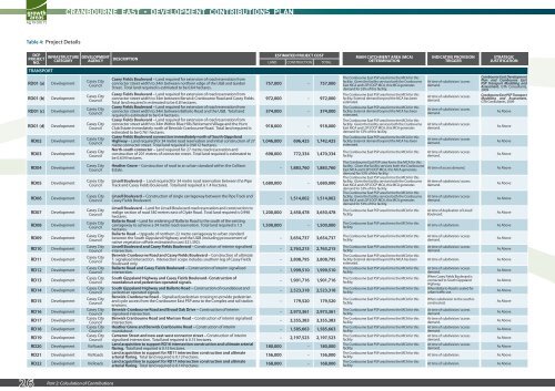
Table 4: Project Details<br />
DCP<br />
PROJECT<br />
NO.<br />
TRANSPORT<br />
INFRASTRUCTURE<br />
CATEGORY<br />
RD01 (a) Development<br />
RD01 (b) Development<br />
RD01 (c) Development<br />
RD01 (d) Development<br />
RD02 Development<br />
RD03 Development<br />
RD04 Development<br />
RD05 Development<br />
RD06 Development<br />
RD07 Development<br />
RD08 Development<br />
RD09 Development<br />
RD10 Development<br />
RD11 Development<br />
RD12 Development<br />
RD13 Development<br />
RD14 Development<br />
RD15 Development<br />
RD16 Development<br />
RD17 Development<br />
RD18 Development<br />
DEVELOPMENT<br />
AGENCY<br />
Casey City<br />
Council<br />
Casey City<br />
Council<br />
Casey City<br />
Council<br />
Casey City<br />
Council<br />
Casey City<br />
Council<br />
Casey City<br />
Council<br />
Casey City<br />
Council<br />
Casey City<br />
Council<br />
Casey City<br />
Council<br />
Casey City<br />
Council<br />
Casey City<br />
Council<br />
Casey City<br />
Council<br />
Casey City<br />
Council<br />
Casey City<br />
Council<br />
Casey City<br />
Council<br />
Casey City<br />
Council<br />
Casey City<br />
Council<br />
Casey City<br />
Council<br />
Casey City<br />
Council<br />
Casey City<br />
Council<br />
Casey City<br />
Council<br />
RD19 Development<br />
Casey City<br />
Council<br />
RD20 Development VicRoads<br />
RD21 Development VicRoads<br />
RD22 Development VicRoads<br />
26 Part 2: Calculation of Contributions<br />
DESCRIPTION<br />
Casey Fields Boulevard – Land required for extension of road reservation from<br />
connector street width to 34m between northern edge of the UGB and Garden<br />
Street. Total land required is estimated to be 0.64 hectares.<br />
Casey Fields Boulevard – Land required for extension of road reservation from<br />
connector street width to 34m between Berwick <strong>Cranbourne</strong> Road and Casey Fields.<br />
Total land required is estimated to be 0.8 hectares.<br />
Casey Fields Boulevard – Land required for extension of road reservation from<br />
connector street width to 34m between Ballarto Road and the UGB. Total land<br />
required is estimated to be 0.4 hectares.<br />
Casey Fields Boulevard – Land required for extension of road reservation from<br />
connector street width to 34m Within Blue Hills Retirement Village and the Hunt<br />
Club Estate immediately north of Berwick-<strong>Cranbourne</strong> Road. Total land required is<br />
estimated to be 0.761 hectares.<br />
Casey Fields Boulevard connection immediately north of South Gippsland<br />
Highway – Land required for 34 metre road reservation and initial construction of 27<br />
metre connector street. Total land required is 0.9012 hectares.<br />
North-south connector – Land required for 27 metre road reservation and<br />
construction of 201 metres of connector street. Total land required is estimated to<br />
be 0.634 hectares.<br />
Heather Grove – Construction of road to an urban standard within the Collison<br />
Estate.<br />
Linsell Boulevard – Land required for 34 metre road reservation between the Pipe<br />
Track and Casey Fields Boulevard. Total land required is 1.4 hectares.<br />
Linsell Boulevard – Construction of single carriageway between the Pipe Track and<br />
Casey Fields Boulevard.<br />
Linsell Boulevard – Land for Linsell Boulevard road reservation and construction to<br />
realign section of road 340 metres east of Clyde Road. Total land required is 0.998<br />
hectares.<br />
Ballarto Road – Land for widening of Ballarto Road to the south of the existing<br />
carriageway to achieve a 34 metre road reservation. Total land required is 1.5<br />
hectares.<br />
Ballarto Road – Upgrade of northern 22 metre carriageway to urban standard<br />
between the South Gippsland Highway and the UGB (including procurement of<br />
native vegetation offsets estimated to cost $21,392).<br />
Linsell Boulevard and Casey Fields Boulevard – Construction of interim signalised<br />
intersection.<br />
Berwick-<strong>Cranbourne</strong> Road and Casey Fields Boulevard – Construction of ultimate<br />
T- signalised intersection. Intersection scope includes southern leg of Casey Fields<br />
Boulevard only.<br />
Ballarto Road and Casey Fields Boulevard – Construction of interim signalised<br />
intersection.<br />
South Gippsland Highway and Casey Fields Boulevard- Construction of<br />
roundabout and pedestrian operated signals.<br />
South Gippsland Highway and Ballarto Road – Construction of roundabout and<br />
pedestrian operated signals.<br />
Berwick-<strong>Cranbourne</strong> Road – Signalised pedestrian crossing to provide pedestrian<br />
and cycle access from the <strong>Cranbourne</strong> <strong>East</strong> PSP area to the Complex and rail station<br />
environs.<br />
Berwick-<strong>Cranbourne</strong> Road and Broad Oak Drive – Construction of interim<br />
signalised intersection.<br />
Berwick <strong>Cranbourne</strong> Road and Morison Road – Construction of interim signalised<br />
intersection.<br />
Heather Grove and Berwick <strong>Cranbourne</strong> Road – Construction of interim<br />
roundabout.<br />
Cameron Street and new east-west connector street – Construction of interim<br />
signalised intersection. Total land required is 0.15 hectares.<br />
Land acquisition to support RD16 intersection construction and ultimate arterial<br />
flaring. Total land required is 0.15 hectares.<br />
Land acquisition to support for RD11 intersection construction and ultimate<br />
arterial flaring. Total land required is 0.13 hectares.<br />
Land acquisition to support for RD17 intersection construction and ultimate<br />
arterial flaring. Total land required is 0.14 hectares.<br />
ESTIMATED PROJECT COST MAIN CATCHMENT AREA (MCA)<br />
LAND CONSTRUCTION TOTAL<br />
DETERMINATION<br />
757,000 - 757,000<br />
972,000 - 972,000<br />
374,000 - 374,000<br />
918,000 - 918,000<br />
1,046,000 696,425 1,742,425<br />
698,000 772,334 1,470,334<br />
- 1,883,760 1,883,760<br />
1,680,000 - 1,680,000<br />
- 1,514,002 1,514,002<br />
1,200,000 2,450,478 3,650,478<br />
1,500,000 - 1,500,000<br />
- 3,654,737 3,654,737<br />
- 2,763,215 2,763,215<br />
- 3,808,795 3,808,795<br />
- 1,999,510 1,999,510<br />
- 1,901,716 1,901,716<br />
- 2,523,318 2,523,318<br />
- 179,520 179,520<br />
- 2,973,361 2,973,361<br />
- 3,355,383 3,355,383<br />
- 1,585,663 1,585,663<br />
- 2,197,523 2,197,523<br />
180,000 - 180,000<br />
156,000 - 156,000<br />
168,000 - 168,000<br />
The <strong>Cranbourne</strong> <strong>East</strong> PSP area forms the MCA for this<br />
facility. Given the facility services both the <strong>Cranbourne</strong><br />
<strong>East</strong> MCA and LSP3 DCP MCA, this MCA generates<br />
demand for 53% of this facility.<br />
The <strong>Cranbourne</strong> <strong>East</strong> PSP area forms the MCA for this<br />
facility. External demand beyond the MCA has been<br />
estimated.<br />
The <strong>Cranbourne</strong> <strong>East</strong> PSP area forms the MCA for this<br />
facility. External demand beyond the MCA has been<br />
estimated.<br />
The <strong>Cranbourne</strong> <strong>East</strong> PSP area forms the MCA for this<br />
facility. Given the facility services both the <strong>Cranbourne</strong><br />
<strong>East</strong> MCA and LSP3 DCP MCA, this MCA generates<br />
demand for 53% of this facility.<br />
The <strong>Cranbourne</strong> <strong>East</strong> PSP area forms the MCA for this<br />
facility. External demand beyond the MCA has been<br />
estimated.<br />
The <strong>Cranbourne</strong> <strong>East</strong> PSP area forms the MCA for this<br />
facility.<br />
The <strong>Cranbourne</strong> <strong>East</strong> PSP area forms the MCA for this<br />
facility. Given the facility services both the <strong>Cranbourne</strong><br />
<strong>East</strong> MCA and LSP3 DCP MCA, this MCA generates<br />
demand for 53% of this facility.<br />
The <strong>Cranbourne</strong> <strong>East</strong> PSP area forms the MCA for this<br />
facility. Given the facility services both the <strong>Cranbourne</strong><br />
<strong>East</strong> MCA and LSP3 DCP MCA, this MCA generates<br />
demand for 53% of this facility.<br />
The <strong>Cranbourne</strong> <strong>East</strong> PSP area forms the MCA for this<br />
facility. Given the facility services both the <strong>Cranbourne</strong><br />
<strong>East</strong> MCA and LSP3 DCP MCA, this MCA generates<br />
demand for 53% of this facility.<br />
The <strong>Cranbourne</strong> <strong>East</strong> PSP area forms the MCA for this<br />
facility.<br />
The <strong>Cranbourne</strong> <strong>East</strong> PSP area forms the MCA for this<br />
facility.<br />
The <strong>Cranbourne</strong> <strong>East</strong> PSP area forms the MCA for this<br />
facility.<br />
The <strong>Cranbourne</strong> <strong>East</strong> PSP area forms the MCA for this<br />
facility.<br />
The <strong>Cranbourne</strong> <strong>East</strong> PSP area forms the MCA for this<br />
facility. External demand beyond the MCA has been<br />
estimated.<br />
The <strong>Cranbourne</strong> <strong>East</strong> PSP area forms the MCA for this<br />
facility.<br />
The <strong>Cranbourne</strong> <strong>East</strong> PSP area forms the MCA for this<br />
facility.<br />
The <strong>Cranbourne</strong> <strong>East</strong> PSP area forms the MCA for this<br />
facility.<br />
The <strong>Cranbourne</strong> <strong>East</strong> PSP area forms the MCA for this<br />
facility.<br />
The <strong>Cranbourne</strong> <strong>East</strong> PSP area forms the MCA for this<br />
facility.<br />
The <strong>Cranbourne</strong> <strong>East</strong> PSP area forms the MCA for this<br />
facility.<br />
The <strong>Cranbourne</strong> <strong>East</strong> PSP area forms the MCA for this<br />
facility.<br />
The <strong>Cranbourne</strong> <strong>East</strong> PSP area forms the MCA for this<br />
facility.<br />
The <strong>Cranbourne</strong> <strong>East</strong> PSP area forms the MCA for this<br />
facility.<br />
The <strong>Cranbourne</strong> <strong>East</strong> PSP area forms the MCA for this<br />
facility.<br />
The <strong>Cranbourne</strong> <strong>East</strong> PSP area forms the MCA for this<br />
facility.<br />
INDICATIVE PROVISION<br />
TRIGGER<br />
At time of subdivision/ access<br />
demand.<br />
At time of subdivision/ access<br />
demand.<br />
At time of subdivision/ access<br />
demand.<br />
At time of subdivision/ access<br />
demand.<br />
At time of subdivision/ access<br />
demand.<br />
At time of subdivision/ access<br />
demand.<br />
STRATEGIC<br />
JUSTIFICATION<br />
<strong>Cranbourne</strong> <strong>East</strong> Development<br />
<strong>Plan</strong> and <strong>Cranbourne</strong> <strong>East</strong><br />
PSP Transport Modelling and<br />
Assessment, GTA Consultants,<br />
2009<br />
<strong>Cranbourne</strong> <strong>East</strong> PSP Transport<br />
Modelling and Assessment,<br />
GTA Consultants, 2009<br />
As Above<br />
As Above<br />
As Above<br />
As Above<br />
At time of access demand. As Above<br />
At time of subdivision/ access<br />
demand.<br />
At time of subdivision/ access<br />
demand.<br />
At time of duplication of Linsell<br />
Boulevard.<br />
As Above<br />
As Above<br />
As Above<br />
At time of subdivision. As Above<br />
At time of subdivision/ access<br />
demand.<br />
At time of subdivision/ access<br />
demand.<br />
As Above<br />
As Above<br />
At time of subdivision. As Above<br />
At time of subdivision/ access<br />
demand.<br />
When Casey Fields Boulevard is<br />
connected to South Gippsland<br />
Highway.<br />
When Ballarto Road is sealed for<br />
urban traffic use.<br />
When subdivision to the south is<br />
constructed.<br />
At time of subdivision/ access<br />
demand.<br />
At time of subdivision/ access<br />
demand.<br />
At time of subdivision/ access<br />
demand.<br />
At time of subdivision/ access<br />
demand.<br />
At time of subdivision/ access<br />
demand.<br />
As Above<br />
As Above<br />
As Above<br />
As Above<br />
As Above<br />
As Above<br />
As Above<br />
As Above<br />
As Above<br />
At time of subdivision. As Above<br />
At time of subdivision. As Above<br />
cranbourne east development contributions plan<br />
SM | 20100511 02:03


