

here. - Ministry of Forests, Lands and Natural Resource Operations
here. - Ministry of Forests, Lands and Natural Resource Operations
here. - Ministry of Forests, Lands and Natural Resource Operations

Create successful ePaper yourself
Turn your PDF publications into a flip-book with our unique Google optimized e-Paper software.
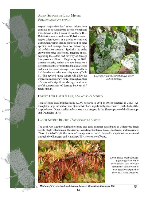
aSPen Se r P e n t I n e le a f MI n e r,<br />
phyllocnistis p o p u l i e l l a<br />
Aspen serpentine leaf miner infestations<br />
continue to be widespread across wetbelt <strong>and</strong><br />
transitional wetbelt areas <strong>of</strong> southern B.C.<br />
Defoliation was recorded on 92,160 hectares.<br />
Aspen <strong>of</strong>ten occurs in a patchy or scattered<br />
distribution within st<strong>and</strong>s comprised <strong>of</strong> other<br />
species, <strong>and</strong> damage does not follow typical<br />
defoliation patterns. Typically the entire<br />
crown <strong>of</strong> the tree is affected. Because <strong>of</strong> this,<br />
capturing the extent <strong>and</strong> severity <strong>of</strong> damage<br />
has proven difficult. Beginning in 2012,<br />
damage severity ratings are now based on a<br />
percentage <strong>of</strong> the overall st<strong>and</strong> that is affected<br />
<strong>and</strong> uses the same damage level cut<strong>of</strong>fs as<br />
bark beetles <strong>and</strong> other mortality agents (Table<br />
1). This revised rating system will allow for<br />
improved consistency, more thorough capture<br />
<strong>of</strong> areas with significant damage, <strong>and</strong> more<br />
useful comparisons <strong>of</strong> damage between different<br />
st<strong>and</strong>s.<br />
fo r e S t te n t cat e r P I l l a r, ma l a c o s o m a Disstria<br />
Total affected area dropped from 42,790 hectares in 2011 to 10,560 hectares in 2012. Although<br />
the large infestation near Quesnel declined significantly, it accounted for the bulk <strong>of</strong> the<br />
mapped area. Other smaller infestations were mapped in the Shuswap area <strong>of</strong> the Kamloops<br />
<strong>and</strong> Okanagan TSAs.<br />
la r c h ne e d l e Bl I g h t, hy p o D e r m e l l a l a r i c i s<br />
The cool, wet weather during the spring <strong>and</strong> early summer contributed to widespread larch<br />
needle blight infections in the Arrow, Boundary, Kootenay Lake, Cranbrook, <strong>and</strong> Invermere<br />
TSAs. A total <strong>of</strong> 31,695 hectares <strong>of</strong> damage was recorded. Several larch plantations scattered<br />
through the Okanagan <strong>and</strong> Kamloops TSAs were also affected.<br />
<strong>Ministry</strong> <strong>of</strong> <strong>Forests</strong>, <strong>L<strong>and</strong>s</strong> <strong>and</strong> <strong>Natural</strong> <strong>Resource</strong> <strong>Operations</strong>, Kamloops, B.C.<br />
14<br />
Close-up <strong>of</strong> aspen serpentine leaf miner<br />
feeding damage.<br />
Larch needle blight damage.<br />
Lighter yellow needles<br />
show current year infection<br />
symptoms; darker needles<br />
with black fruiting bodies<br />
show past years’ infection.


