here. - Ministry of Forests, Lands and Natural Resource Operations
here. - Ministry of Forests, Lands and Natural Resource Operations
here. - Ministry of Forests, Lands and Natural Resource Operations
Create successful ePaper yourself
Turn your PDF publications into a flip-book with our unique Google optimized e-Paper software.
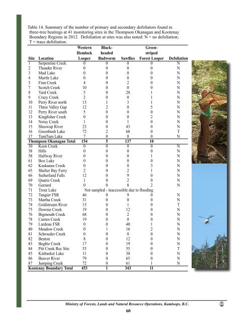
Table 14. Summary <strong>of</strong> the number <strong>of</strong> primary <strong>and</strong> secondary defoliators found in<br />
three-tree beatings at 41 monitoring sites in the Thompson Okanagan <strong>and</strong> Kootenay<br />
Boundary Regions in 2012. Defoliation at sites was also noted: N = no defoliation;<br />
T = trace defoliation.<br />
Western Black- Green-<br />
Hemlock headed striped<br />
Site Location Looper Budworm Sawflies Forest Looper Defoliation<br />
1 Serpentine Creek 0 0 0 0 N<br />
2 Thunder River 0 0 0 0 N<br />
3 Mud Lake 0 0 0 0 N<br />
4 Murtle Lake 0 0 0 0 N<br />
5 Finn Creek 4 0 2 0 N<br />
7 Scotch Creek 10 0 0 0 N<br />
8 Yard Creek 5 0 20 1 N<br />
9 Crazy Creek 2 0 0 1 N<br />
10 Perry River north 13 1 3 1 N<br />
11 Three Valley Gap 12 2 0 5 N<br />
12 Perry River south 5 0 0 0 N<br />
13 Kingfisher Creek 0 0 0 2 N<br />
14 Noisy Creek 1 0 1 0 N<br />
15 Shuswap River 23 0 43 0 N<br />
16 Greenbush Lake 72 2 68 0 T<br />
17 TumTum Lake 7 0 0 0 N<br />
Thompson Okanagan Total 154 5 137 10<br />
30 Keen Creek 0 0 0 0 N<br />
38 Hills 0 0 0 0 N<br />
58 Halfway River 0 0 0 1 N<br />
61 Box Lake 0 0 0 0 N<br />
62 Kuskanax Creek 0 0 0 3 N<br />
65 Shelter Bay Ferry 2 0 2 1 N<br />
66 Sutherl<strong>and</strong> Falls 12 0 9 0 N<br />
69 Quartz Creek 1 0 2 0 N<br />
70 Gerrard 0 0 8 2 N<br />
71 Trout Lake Not sampled - inaccessible due to flooding<br />
72 Tangier FSR 46 0 9 0 N<br />
73 Martha Creek 31 0 0 0 N<br />
74 Goldstream River 15 0 1 0 T<br />
75 Downie Creek 19 0 12 0 N<br />
76 Bigmouth Creek 68 0 2 0 N<br />
78 Carnes Creek 19 0 0 0 N<br />
79 Lardeau FSR 0 0 40 1 N<br />
80 Meadow Creek 0 1 16 2 N<br />
81 Schroeder Creek 0 0 0 0 N<br />
82 Beaton 8 0 12 0 N<br />
83 Begbie Creek 17 0 19 0 N<br />
84 Pitt Creek Rec Site 53 0 55 0 T<br />
85 Kinbasket Lake 11 0 30 0 N<br />
86 Beaver River 79 0 65 0 N<br />
87 Jumping Creek 72 0 61 1 N<br />
Kootenay Boundary Total 453 1 343 11<br />
<strong>Ministry</strong> <strong>of</strong> <strong>Forests</strong>, <strong>L<strong>and</strong>s</strong> <strong>and</strong> <strong>Natural</strong> <strong>Resource</strong> <strong>Operations</strong>, Kamloops, B.C.<br />
60


