

here. - Ministry of Forests, Lands and Natural Resource Operations
here. - Ministry of Forests, Lands and Natural Resource Operations
here. - Ministry of Forests, Lands and Natural Resource Operations

Create successful ePaper yourself
Turn your PDF publications into a flip-book with our unique Google optimized e-Paper software.
In v e r M e r e tSa<br />
Bark Beetles<br />
Mountain pine beetle infestations continued to decline, with area affected down by 50% to 8,225 hectares. The<br />
number <strong>of</strong> spot infestations was down as well, from 670 to 448. Areas east <strong>of</strong> the Rocky Mountain Trench, including<br />
the Kootenay River, Palliser River, <strong>and</strong> Lussier River, saw the most significant declines. However, despite<br />
the overall declining trend, red attack is still widespread, <strong>and</strong> present in most areas <strong>of</strong> the TSA. Whitebark pine<br />
mortality was common in the northwestern portion <strong>of</strong> the TSA, especially near Bobbie Burns Creek, Frances<br />
Creek, <strong>and</strong> the Spillimacheen River, with affected area increasing to 1,615 hectares.<br />
Most active Douglas-fir beetle was in Kootenay National<br />
Park <strong>and</strong> in the lower Lussier River. Total affected<br />
area was up by 75% to 743 hectares. The number <strong>of</strong><br />
spot infestations also increased from 36 to 65. A few<br />
other scattered pockets were mapped around East White<br />
River, Kindersley Creek, <strong>and</strong> Premier Lake.<br />
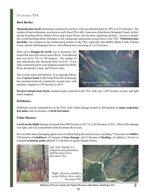
The overall extent <strong>and</strong> intensity <strong>of</strong> an ongoing infestation<br />
<strong>of</strong> spruce beetle in the North White River drainage<br />
has remained relatively constant for several years, with<br />
mortality mapped on 550 hectares in 2012.<br />
Western balsam bark beetle remained quite scattered in the TSA, with only 1,093 hectares <strong>of</strong> trace <strong>and</strong> light<br />
attack mapped.<br />
Defoliators<br />
Defoliator activity remained low in the TSA, with visible damage limited to 206 hectares <strong>of</strong> aspen serpentine<br />
leaf miner <strong>and</strong> six hectares <strong>of</strong> birch leaf miner.<br />
Foliar Diseases<br />
Larch needle blight damage increased from 900 hectares in 2011 to 2,361 hectares in 2012. Most <strong>of</strong> the damage<br />
was light, <strong>and</strong> was concentrated in the Kootenay River area.<br />
Several other minor damaging agents were recorded during the aerial surveys, including 775 hectares <strong>of</strong> wildfire,<br />
358 hectares <strong>of</strong> windthrow, 63 hectares <strong>of</strong> bear damage, <strong>and</strong> 31 hectares <strong>of</strong> flooding. In addition, 156 new or<br />
widened avalanche paths affected 333 hectares <strong>of</strong> spruce-balsam forests.<br />
Left: bear damage in a<br />
lodgepole pine plantation,<br />
Spillimacheen River,<br />
Invermere TSA.<br />
Right: extensive windthrow<br />
in the Palliser River valley,<br />
Invermere TSA.<br />
<strong>Ministry</strong> <strong>of</strong> <strong>Forests</strong>, <strong>L<strong>and</strong>s</strong> <strong>and</strong> <strong>Natural</strong> <strong>Resource</strong> <strong>Operations</strong>, Kamloops, B.C.<br />
32<br />
Spruce beetle attack in the North White River<br />
valley, Invermere TSA.


