

Desktop Environmental, Hydrological and Geotechnical Study
Desktop Environmental, Hydrological and Geotechnical Study
Desktop Environmental, Hydrological and Geotechnical Study

You also want an ePaper? Increase the reach of your titles
YUMPU automatically turns print PDFs into web optimized ePapers that Google loves.
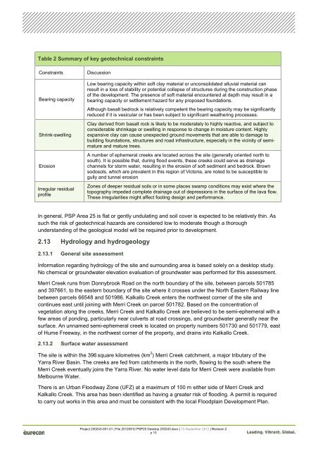
Table 2 Summary of key geotechnical constraints<br />
Constraints Discussion<br />
Bearing capacity<br />
Shrink-swelling<br />
Erosion<br />
Irregular residual<br />
profile<br />
Low bearing capacity within soft clay material or unconsolidated alluvial material can<br />
result in a loss of stability or potential collapse of structures during the construction phase<br />
of the development. The presence of soft material encountered at depth may result in a<br />
bearing capacity or settlement hazard for any proposed foundations.<br />
Although basalt bedrock is relatively competent the bearing capacity may be significantly<br />
reduced if it is vesicular or has been subject to significant weathering processes.<br />
Clay derived from basalt rock is likely to be moderately to highly reactive, <strong>and</strong> subject to<br />
considerable shrinkage or swelling in response to change in moisture content. Highly<br />
expansive clay can cause unexpected ground movements that are able to damage to<br />
building foundations, structures <strong>and</strong> road infrastructure, especially in the vicinity of semimature<br />
<strong>and</strong> mature trees.<br />
A number of ephemeral creeks are located across the site (generally oriented north to<br />
south). It is possible that, during flood events, these creeks could serve as drainage<br />
channels for storm water, resulting in the erosion of soft sediment <strong>and</strong> bedrock. Brown<br />
sodosols, which are prevalent in this region of Victoria, are noted to be susceptible to<br />
gully <strong>and</strong> tunnel erosion<br />
Zones of deeper residual soils or in some places swamp conditions may exist where the<br />
topography impeded complete drainage out of depressions in the surface of the lava flow.<br />
These irregularities might affect footing design <strong>and</strong> performance.<br />
In general, PSP Area 25 is flat or gently undulating <strong>and</strong> soil cover is expected to be relatively thin. As<br />
such the risk of geotechnical hazards are considered low to moderate though a thorough<br />
underst<strong>and</strong>ing of the geological model will be required prior to development.<br />
2.13 Hydrology <strong>and</strong> hydrogeology<br />
2.13.1 General site assessment<br />
Information regarding hydrology of the site <strong>and</strong> surrounding area is based solely on a desktop study.<br />
No chemical or groundwater elevation evaluation of groundwater was performed for this assessment.<br />
Merri Creek runs from Donnybrook Road on the north boundary of the site, between parcels 501785<br />
<strong>and</strong> 397661, to the eastern boundary of the site where it crosses under the North Eastern Railway line<br />
between parcels 66548 <strong>and</strong> 501986. Kalkallo Creek enters the northwest corner of the site <strong>and</strong><br />
continues east until joining with Merri Creek on parcel 501782. Based on the concentration of<br />
vegetation along the creeks, Merri Creek <strong>and</strong> Kalkallo Creek are believed to be semi-ephemeral with a<br />
few areas of ponding, particularly near culverts at road crossings, <strong>and</strong> groundwater generally near the<br />
surface. An unnamed semi-ephemeral creek is located on property numbers 501730 <strong>and</strong> 501779, east<br />
of Hume Freeway, in the northwest corner of the property, <strong>and</strong> drains into Kalkallo Creek.<br />
2.13.2 Surface water assessment<br />
The site is within the 396 square kilometres (km 2 ) Merri Creek catchment, a major tributary of the<br />
Yarra River Basin. The creeks are fed from catchments in the north, flowing to the south where the<br />
Merri Creek eventually joins the Yarra River. No water level data for Merri Creek were available from<br />
Melbourne Water.<br />
There is an Urban Floodway Zone (UFZ) at a maximum of 100 m either side of Merri Creek <strong>and</strong><br />
Kalkallo Creek. This area has been identified as having a greater risk of flooding. A permit is required<br />
to carry out works in this area <strong>and</strong> must be consistent with the local Floodplain Development Plan.<br />
Project 230243-001-01 | File 20120912 PSP25 <strong>Desktop</strong> 230243.docx | 13 September 2012 | Revision 2<br />
p 10


