

Desktop Environmental, Hydrological and Geotechnical Study
Desktop Environmental, Hydrological and Geotechnical Study
Desktop Environmental, Hydrological and Geotechnical Study

Create successful ePaper yourself
Turn your PDF publications into a flip-book with our unique Google optimized e-Paper software.
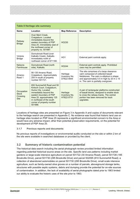
Table 8 Heritage site summary<br />
Name Location Map Reference Description<br />
Railway<br />
Bridge<br />
Victoria<br />
Bridge<br />
Nelsons<br />
Farmhouse<br />
Amaroo<br />
Road 1<br />
Occupation<br />
Stock<br />
Crossing<br />
Site<br />
Over Merri Creek,<br />
Craigieburn. Located<br />
immediately beyond the<br />
eastern boundary of PSP<br />
Area 25, immediately east of<br />
the northeast corner of<br />
property no. 501987.<br />
Donnybrook Road (over<br />
Kalkallo Creek), Kalkallo.<br />
Immediately north of<br />
northeast corner of 671180.<br />
Donnybrook Road (north<br />
side), Kalkallo.<br />
95-135 Amaroo Road,<br />
Craigieburn. Approximately<br />
200 m south of property<br />
number 501721.<br />
650 Summerhill Road <strong>and</strong> 50<br />
Kinloch Court, Craigieburn,<br />
Hume City. Located<br />
immediately beyond the<br />
eastern boundary of PSP<br />
Area 25, approximately 125<br />
m northeast of the south<br />
corner of property number<br />
501988.<br />
HO230<br />
HO1 External paint controls apply.<br />
HO244<br />
Heritage<br />
Inventory No.<br />
D7822-0844<br />
Heritage<br />
Inventory No.<br />
H7822-0731<br />
External paint controls apply. Prohibited<br />
uses may be permitted.<br />
The site comprises of a large clearance<br />
cairn composed of collected basalt<br />
fieldstones. The cairn is elliptical in shape<br />
<strong>and</strong> approximately 0.5 m high by 20 m x 10<br />
m. The cairn is partially overgrown.<br />
A pair of rectangular platforms constructed<br />
of basalt blocks, designed to enable stock<br />
to cross the railway tracks. The central<br />
portion has been removed for track<br />
upgrades.<br />
Locations of heritage sites are presented on Figure 3 in Appendix A <strong>and</strong> copies of documents relevant<br />
to the heritage search are presented in Appendix C. No evidence was found that historic l<strong>and</strong> use on<br />
heritage sites located on PSP Area 25 represents a significant environmental concern to the Area or<br />
would have any adverse impact, other than potential preservation requirements, on the potential for<br />
development of PSP Area 25.<br />
3.1.7 Previous reports <strong>and</strong> documents<br />
No previous reports of investigations or environmental audits conducted on the site or within 2 km of<br />
the site were available in searched databases or provided by the client.<br />
3.2 Summary of historic contamination potential<br />
The historical data search including the aerial photograph review provided limited information<br />
regarding potential historical source areas on the site. Specific l<strong>and</strong> use patterns including market<br />
gardens or large-scale intensive agriculture on parcel 501722 (30 Amaroo Road), parcel 501726 (185<br />
Brookville Drive), parcel 501730 (295 Brookville Drive) <strong>and</strong> parcel 502095 (810 Summerhill Road); a<br />
collection of ab<strong>and</strong>oned automobiles on parcel 501730 (295 Brookville Drive), small scale intensive<br />
agriculture, such as family-owned olive groves on a number of parcels, aboveground storage tanks,<br />
structures with possible septic systems, debris <strong>and</strong> dumping provide the potential for on-site sources<br />
of contamination. In addition, the lack of availability of aerial photographs dated prior to 1963 limited<br />
our ability to evaluate the historic uses of the site prior to 1963.<br />
Project 230243-001-01 | File 20120912 PSP25 <strong>Desktop</strong> 230243.docx | 13 September 2012 | Revision 2<br />
p 19


