

Desktop Environmental, Hydrological and Geotechnical Study
Desktop Environmental, Hydrological and Geotechnical Study
Desktop Environmental, Hydrological and Geotechnical Study

Create successful ePaper yourself
Turn your PDF publications into a flip-book with our unique Google optimized e-Paper software.
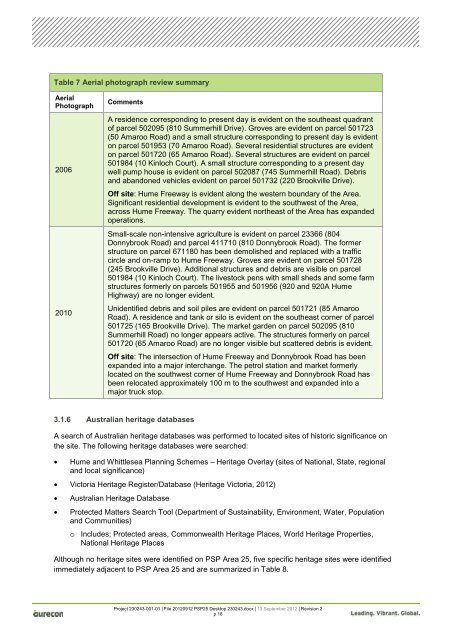
Table 7 Aerial photograph review summary<br />
Aerial<br />
Photograph<br />
2006<br />
2010<br />
Comments<br />
A residence corresponding to present day is evident on the southeast quadrant<br />
of parcel 502095 (810 Summerhill Drive). Groves are evident on parcel 501723<br />
(50 Amaroo Road) <strong>and</strong> a small structure corresponding to present day is evident<br />
on parcel 501953 (70 Amaroo Road). Several residential structures are evident<br />
on parcel 501720 (65 Amaroo Road). Several structures are evident on parcel<br />
501984 (10 Kinloch Court). A small structure corresponding to a present day<br />
well pump house is evident on parcel 502087 (745 Summerhill Road). Debris<br />
<strong>and</strong> ab<strong>and</strong>oned vehicles evident on parcel 501732 (220 Brookville Drive).<br />
Off site: Hume Freeway is evident along the western boundary of the Area.<br />
Significant residential development is evident to the southwest of the Area,<br />
across Hume Freeway. The quarry evident northeast of the Area has exp<strong>and</strong>ed<br />
operations.<br />
Small-scale non-intensive agriculture is evident on parcel 23366 (804<br />
Donnybrook Road) <strong>and</strong> parcel 411710 (810 Donnybrook Road). The former<br />
structure on parcel 671180 has been demolished <strong>and</strong> replaced with a traffic<br />
circle <strong>and</strong> on-ramp to Hume Freeway. Groves are evident on parcel 501728<br />
(245 Brookville Drive). Additional structures <strong>and</strong> debris are visible on parcel<br />
501984 (10 Kinloch Court). The livestock pens with small sheds <strong>and</strong> some farm<br />
structures formerly on parcels 501955 <strong>and</strong> 501956 (920 <strong>and</strong> 920A Hume<br />
Highway) are no longer evident.<br />
Unidentified debris <strong>and</strong> soil piles are evident on parcel 501721 (85 Amaroo<br />
Road). A residence <strong>and</strong> tank or silo is evident on the southeast corner of parcel<br />
501725 (165 Brookville Drive). The market garden on parcel 502095 (810<br />
Summerhill Road) no longer appears active. The structures formerly on parcel<br />
501720 (65 Amaroo Road) are no longer visible but scattered debris is evident.<br />
Off site: The intersection of Hume Freeway <strong>and</strong> Donnybrook Road has been<br />
exp<strong>and</strong>ed into a major interchange. The petrol station <strong>and</strong> market formerly<br />
located on the southwest corner of Hume Freeway <strong>and</strong> Donnybrook Road has<br />
been relocated approximately 100 m to the southwest <strong>and</strong> exp<strong>and</strong>ed into a<br />
major truck stop.<br />
3.1.6 Australian heritage databases<br />
A search of Australian heritage databases was performed to located sites of historic significance on<br />
the site. The following heritage databases were searched:<br />
• Hume <strong>and</strong> Whittlesea Planning Schemes – Heritage Overlay (sites of National, State, regional<br />
<strong>and</strong> local significance)<br />
• Victoria Heritage Register/Database (Heritage Victoria, 2012)<br />
• Australian Heritage Database<br />
• Protected Matters Search Tool (Department of Sustainability, Environment, Water, Population<br />
<strong>and</strong> Communities)<br />
o Includes; Protected areas, Commonwealth Heritage Places, World Heritage Properties,<br />
National Heritage Places<br />
Although no heritage sites were identified on PSP Area 25, five specific heritage sites were identified<br />
immediately adjacent to PSP Area 25 <strong>and</strong> are summarized in Table 8.<br />
Project 230243-001-01 | File 20120912 PSP25 <strong>Desktop</strong> 230243.docx | 13 September 2012 | Revision 2<br />
p 18


