

Desktop Environmental, Hydrological and Geotechnical Study
Desktop Environmental, Hydrological and Geotechnical Study
Desktop Environmental, Hydrological and Geotechnical Study

Create successful ePaper yourself
Turn your PDF publications into a flip-book with our unique Google optimized e-Paper software.
Drainage paths have been determined for the area from the contour plan. The drainage paths are<br />
areas of likely surface water flows during rainfall events <strong>and</strong> appropriate drainage infrastructure will be<br />
required to manage these flows if developing in these areas. Drainage paths are depicted on Figure 2<br />
presented in Appendix A.<br />
2.13.3 Groundwater assessment<br />
The Victorian Water Resources Data Warehouse (DSE, 2012b) <strong>and</strong> GeoVic (DPI, 2012) GIS tools<br />
identified 30 registered boreholes within 1 km of the site. No groundwater level information was<br />
available for the boreholes located on the site. The closest borehole to the site for which groundwater<br />
level data was available was borehole B68888, located approximately 665 m south of site southern<br />
boundary, at 95-135 Amaroo Road. This borehole shows a groundwater depth on 1 April 2009 of<br />
15.71 m below ground level (bgl).<br />
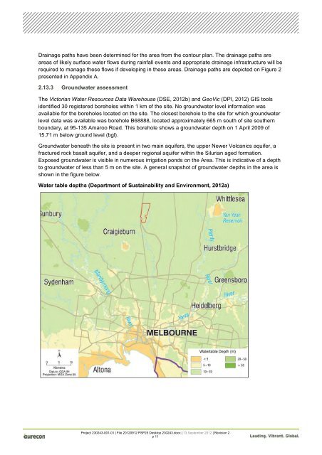
Groundwater beneath the site is present in two main aquifers, the upper Newer Volcanics aquifer, a<br />
fractured rock basalt aquifer, <strong>and</strong> a deeper regional aquifer within the Silurian aged formation.<br />
Exposed groundwater is visible in numerous irrigation ponds on the Area. This is indicative of a depth<br />
to groundwater of less than 5 m on the site. A general snapshot of groundwater depths in the area is<br />
shown in the figure below.<br />
Water table depths (Department of Sustainability <strong>and</strong> Environment, 2012a)<br />
Project 230243-001-01 | File 20120912 PSP25 <strong>Desktop</strong> 230243.docx | 13 September 2012 | Revision 2<br />
p 11


