Geopark LM 3 Englisch 2007.indd - Geopark Harz
Geopark LM 3 Englisch 2007.indd - Geopark Harz
Geopark LM 3 Englisch 2007.indd - Geopark Harz

You also want an ePaper? Increase the reach of your titles
YUMPU automatically turns print PDFs into web optimized ePapers that Google loves.
Vision Jura Park<br />
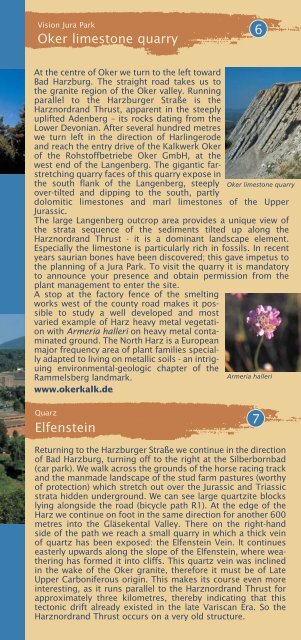
Oker limestone quarry<br />
6<br />
At the centre of Oker we turn to the left toward<br />
Bad <strong>Harz</strong>burg. The straight road takes us to<br />
the granite region of the Oker valley. Running<br />
parallel to the <strong>Harz</strong>burger Straße is the<br />
<strong>Harz</strong>nordrand Thrust, apparent in the steeply<br />
uplifted Adenberg – its rocks dating from the<br />
Lower Devonian. After several hundred metres<br />
we turn left in the direction of Harlingerode<br />
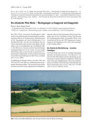
and reach the entry drive of the Kalkwerk Oker<br />
of the Rohstoffbetriebe Oker GmbH, at the<br />
west end of the Langenberg. The gigantic farstretching<br />
quarry faces of this quarry expose in<br />
the south flank of the Langenberg, steeply Oker limestone quarry<br />
over-tilted and dipping to the south, partly<br />
dolomitic limestones and marl limestones of the Upper<br />
Jurassic.<br />
The large Langenberg outcrop area provides a unique view of<br />
the strata sequence of the sediments tilted up along the<br />
<strong>Harz</strong>nordrand Thrust - it is a dominant landscape element.<br />
Especially the limestone is particularly rich in fossils. In recent<br />
years saurian bones have been discovered; this gave impetus to<br />
the planning of a Jura Park. To visit the quarry it is mandatory<br />
to announce your presence and obtain permission from the<br />
plant management to enter the site.<br />
A stop at the factory fence of the smelting<br />
works west of the county road makes it possible<br />
to study a well developed and most<br />
varied example of <strong>Harz</strong> heavy metal vegetation<br />
with Armeria halleri on heavy metal contaminated<br />
ground. The North <strong>Harz</strong> is a European<br />
major frequency area of plant families specially<br />
adapted to living on metallic soils - an intriguing<br />
environmental-geologic chapter of the<br />
Rammelsberg landmark.<br />
Armeria halleri<br />
www.okerkalk.de<br />
Quarz<br />
Elfenstein<br />
7<br />
Returning to the <strong>Harz</strong>burger Straße we continue in the direction<br />
of Bad <strong>Harz</strong>burg, turning off to the right at the Silberbornbad<br />
(car park). We walk across the grounds of the horse racing track<br />
and the manmade landscape of the stud farm pastures (worthy<br />
of protection) which stretch out over the Jurassic and Triassic<br />
strata hidden underground. We can see large quartzite blocks<br />
lying alongside the road (bicycle path R1). At the edge of the<br />
<strong>Harz</strong> we continue on foot in the same direction for another 600<br />
metres into the Gläsekental Valley. There on the right-hand<br />
side of the path we reach a small quarry in which a thick vein<br />
of quartz has been exposed: the Elfenstein Vein. It continues<br />
easterly upwards along the slope of the Elfenstein, where weathering<br />
has formed it into cliffs. This quartz vein was inclined<br />
in the wake of the Oker granite, therefore it must be of Late<br />
Upper Carboniferous origin. This makes its course even more<br />
interesting, as it runs parallel to the <strong>Harz</strong>nordrand Thrust for<br />
approximately three kilometres, thereby indicating that this<br />
tectonic drift already existed in the late Variscan Era. So the<br />
<strong>Harz</strong>nordrand Thrust occurs on a very old structure.