Pacific Islands Environment Outlook - UNEP
Pacific Islands Environment Outlook - UNEP
Pacific Islands Environment Outlook - UNEP

Create successful ePaper yourself
Turn your PDF publications into a flip-book with our unique Google optimized e-Paper software.
ATMOSPHERE 19<br />
The findings of the Intergovernmental Panel on<br />
Climate Change (IPCC) (Houghton et al. 1996) confirm<br />
that ‘the balance of evidence suggests a discernible<br />
human influence on global climate’ and that ‘more<br />
convincing recent evidence for the attribution of a<br />
human effect on climate is emerging…’, which is<br />
unlikely to be ‘a result of natural internal variability’<br />
(Watson, Zinyowera and Moss 1998). This is of on-going<br />
and particular concern to <strong>Pacific</strong> island governments<br />
and peoples, most of whose lives are entirely coastal in<br />
nature (SPREP 1993a).<br />
The three greatest anticipated consequences of any<br />
global warming are expected to be sea-level rise, an<br />
increase in climate-related natural disasters (storms,<br />
floods and droughts) and disruption to agriculture due to<br />
changes in temperature, rainfall and winds. The IPCC has<br />
noted that the ‘best estimate’ of sea-level rise from the<br />
present to the year 2100 is 50 cm, with a range for all<br />
scenarios of 15–95 cm by the end of the century.<br />
In the <strong>Pacific</strong>, areas under threat have been identified<br />
as marine ecosystems, coastal systems, tourism, human<br />
settlement and infrastructure (IPCC 1998). There is<br />
growing evidence that the nature of impacts in this<br />
region is indicative of a changing climate. The region has<br />
lost atolls due to rising seas and has experienced more<br />
extreme events and weather, coupled with El Niño. The<br />
results have included water shortages and drought in<br />
PNG, Marshall <strong>Islands</strong>, FSM, American Samoa, Samoa<br />
and Fiji, and floods in New Zealand. Data gathered by<br />
New Zealand’s National Institute of Water and<br />
Atmospheric Research (NIWA) also show a general<br />
change in the South <strong>Pacific</strong> climate from the mid-1970s:<br />
●<br />
●<br />
●<br />
●<br />
●<br />
Kiribati, northern Cook <strong>Islands</strong>, Tokelau and northern<br />
parts of French Polynesia have become wetter;<br />
New Caledonia, Fiji and Tonga have become drier;<br />
Samoa, eastern Kiribati, Tokelau and northeast<br />
French Polynesia have become warmer and cloudier<br />
and the difference between daytime and night-time<br />
temperatures has decreased;<br />
New Caledonia, Fiji, Tonga, southern Cook <strong>Islands</strong><br />
and southwest French Polynesia have become<br />
warmer and sunnier;<br />
Western Kiribati and Tuvalu have become sunnier.<br />
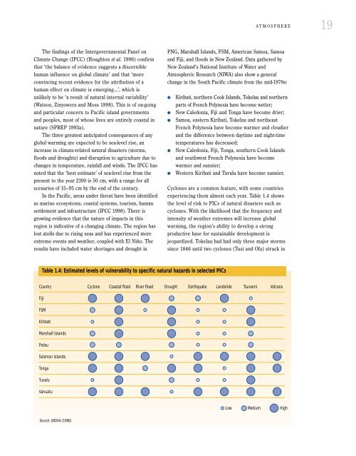
Cyclones are a common feature, with some countries<br />
experiencing them almost each year. Table 1.4 shows<br />
the level of risk to PICs of natural disasters such as<br />
cyclones. With the likelihood that the frequency and<br />
intensity of weather extremes will increase global<br />
warming, the region’s ability to develop a strong<br />
productive base for sustainable development is<br />
jeopardized. Tokelau had had only three major storms<br />
since 1846 until two cyclones (Tusi and Ofa) struck in<br />
Table 1.4: Estimated levels of vulnerability to specific natural hazards in selected PICs<br />
Country<br />
Cyclone Coastal flood River flood Drought Earthquake Landslide Tsunami Volcano<br />
Fiji<br />
FSM<br />
Kiribati<br />
Marshall <strong>Islands</strong><br />
Palau<br />
Solomon <strong>Islands</strong><br />
Tonga<br />
Tuvalu<br />
Vanuatu<br />
Low Medium High<br />
Source: UNDHA (1996)