web_vol47 4.pdf - International Hospital Federation
web_vol47 4.pdf - International Hospital Federation
web_vol47 4.pdf - International Hospital Federation

You also want an ePaper? Increase the reach of your titles
YUMPU automatically turns print PDFs into web optimized ePapers that Google loves.
Policy: Japan<br />
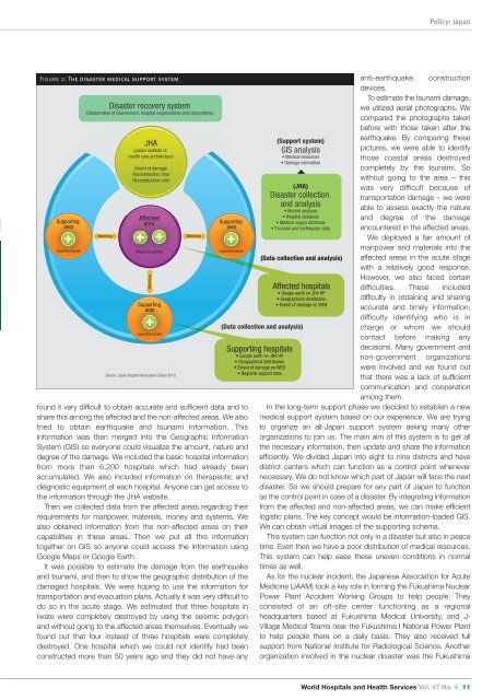
Figure 2: The disaster medical support system<br />
Supporting<br />
area<br />
Supporting hospitals<br />
Disaster recovery system<br />
Collaboration of Government, hospital organizations and corporations<br />
Matching<br />
JHA<br />
(Japan institute of<br />
health care architecture)<br />
Extent of damage<br />
Reconstruction time<br />
Reconstruction cost<br />
Affected<br />
area<br />
Affected hospitals<br />
Supporting<br />
area<br />
Supporting hospitals<br />
Source: Japan <strong>Hospital</strong> Association (Sakai 2011)<br />
Matching<br />
Supporting<br />
area<br />
Supporting hospitals<br />
found it very difficult to obtain accurate and sufficient data and to<br />
share this among the affected and the non-affected areas. We also<br />
tried to obtain earthquake and tsunami information. This<br />
information was then merged into the Geographic Information<br />
System (GIS) so everyone could visualize the amount, nature and<br />
degree of the damage. We included the basic hospital information<br />
from more than 6,200 hospitals which had already been<br />
accumulated. We also included information on therapeutic and<br />
diagnostic equipment at each hospital. Anyone can get access to<br />
the information through the JHA <strong>web</strong>site.<br />
Then we collected data from the affected areas regarding their<br />
requirements for manpower, materials, money and systems. We<br />
also obtained information from the non-affected areas on their<br />
capabilities in these areas. Then we put all this information<br />
together on GIS so anyone could access the information using<br />
Google Maps or Google Earth.<br />
It was possible to estimate the damage from the earthquake<br />
and tsunami, and then to show the geographic distribution of the<br />
damaged hospitals. We were hoping to use the information for<br />
transportation and evacuation plans. Actually it was very difficult to<br />
do so in the acute stage. We estimated that three hospitals in<br />
Iwate were completely destroyed by using the seismic polygon<br />
and without going to the affected areas themselves. Eventually we<br />
found out that four instead of three hospitals were completely<br />
destroyed. One hospital which we could not identify had been<br />
constructed more than 50 years ago and they did not have any<br />
Matching<br />
anti-earthquake construction<br />
devices.<br />
To estimate the tsunami damage,<br />
we utilized aerial photographs. We<br />
compared the photographs taken<br />
before with those taken after the<br />
(Support system) earthquake. By comparing these<br />
GIS analysis<br />
pictures, we were able to identify<br />
• Medical resources<br />
those coastal areas destroyed<br />
• Damage estimation<br />
completely by the tsunami. So<br />
without going to the area – this<br />
(JHA)<br />
was very difficult because of<br />
Disaster collection transportation damage – we were<br />
and analysis<br />
able to assess exactly the nature<br />
• Market analyser<br />
• <strong>Hospital</strong> database<br />
and degree of the damage<br />
• Medical supply database<br />
• Tsunami and earthquake data encountered in the affected areas.<br />
We deployed a fair amount of<br />
manpower and materials into the<br />
(Data collection and analysis) affected areas in the acute stage<br />
with a relatively good response.<br />
However, we also faced certain<br />
Affected hospitals difficulties. These included<br />
• Google earth on JHA HP<br />
• Geographical distribution difficulty in obtaining and sharing<br />
• Extent of damage on WEB<br />
accurate and timely information;<br />
difficulty identifying who is in<br />
charge or whom we should<br />
contact before making any<br />
decisions. Many government and<br />
non-government organizations<br />
were involved and we found out<br />
that there was a lack of sufficient<br />
communication and cooperation<br />
among them.<br />
In the long-term support phase we decided to establish a new<br />
medical support system based on our experience. We are trying<br />
to organize an all-Japan support system asking many other<br />
organizations to join us. The main aim of this system is to get all<br />
the necessary information, then update and share the information<br />
efficiently. We divided Japan into eight to nine districts and have<br />
district centers which can function as a control point whenever<br />
necessary. We do not know which part of Japan will face the next<br />
disaster. So we should prepare for any part of Japan to function<br />
as the control point in case of a disaster. By integrating information<br />
from the affected and non-affected areas, we can make efficient<br />
logistic plans. The key concept would be information-loaded GIS.<br />
We can obtain virtual images of the supporting schema.<br />
This system can function not only in a disaster but also in peace<br />
time. Even then we have a poor distribution of medical resources.<br />
This system can help ease these uneven conditions in normal<br />
times as well.<br />
As for the nuclear incident, the Japanese Association for Acute<br />
Medicine (JAAM) took a key role in forming the Fukushima Nuclear<br />
Power Plant Accident Working Groups to help people. They<br />
consisted of an off-site center functioning as a regional<br />
headquarters based at Fukushima Medical University, and J-<br />
Village Medical Teams near the Fukushima I National Power Plant<br />
to help people there on a daily basis. They also received full<br />
support from National Institute for Radiological Science. Another<br />
organization involved in the nuclear disaster was the Fukushima<br />
(Data collection and analysis)<br />
Supporting hospitals<br />
• Google earth on JHA HP<br />
• Geographical distribution<br />
• Extent of damage on WEB<br />
• Regional support data<br />
World <strong>Hospital</strong>s and Health Services Vol. 47 No. 4 11