Predicting Wetland Plant Community Responses to ... - BioOne
Predicting Wetland Plant Community Responses to ... - BioOne
Predicting Wetland Plant Community Responses to ... - BioOne

You also want an ePaper? Increase the reach of your titles
YUMPU automatically turns print PDFs into web optimized ePapers that Google loves.
752 Wilcox and Xie<br />
non in the Great Lakes due <strong>to</strong> natural climatic variability.<br />
For example, Lake Michigan was less than<br />
half its current size during the mid-Holocene warming<br />
period about 8,500 years ago, and lake levels<br />
were more than 4 m higher than <strong>to</strong>day during the<br />
Nipissing II phase 4,500 years ago. Since that time,<br />
the lake has experienced extreme high and low lake<br />
levels approximately every 150–160 years and<br />
lesser events approximately each 30–33 years<br />
(Thompson and Baedke 1997, Baedke and Thompson<br />
2000). Water-level changes such as these directly<br />
affect the biological communities of the<br />
Great Lakes (Working Committee 2 1993, Wilcox<br />
1995, Maynard and Wilcox 1997, Environment<br />
Canada 2002). The effects are greatest in shallow<br />
water, where even small changes in lake level can<br />
result in conversion of a standing water environment<br />
<strong>to</strong> an environment in which sediments are exposed<br />
<strong>to</strong> the air, or vice versa, resulting in death by<br />
flooding or in plant seed-bank germination (Keddy<br />
and Reznicek 1986, Wilcox 1995). Lake-level regulation<br />
disrupts this natural process.<br />
There is a real need <strong>to</strong> understand the correlation<br />
between water-level patterns and biological<br />
processes that determine wetland plant community<br />
diversity, abundance, and distribution. This information<br />
can then be linked <strong>to</strong> habitat requirements<br />
for wetland fish and wildlife communities. Together,<br />
the information gained would enable development<br />
of water-regulation criteria important <strong>to</strong><br />
wetland communities and assessment models for<br />
use in evaluating alternative water-regulation plans<br />
(Wilcox et al. 2005, Hudon et al. 2006).<br />
In 2001, the International Joint Commission<br />
(IJC) under<strong>to</strong>ok a bi-national study of the regulation<br />
plan for Lake Ontario, with the potential objective<br />
of developing a new plan that better serves the<br />
interests of hydropower, shipping, water supply,<br />
recreational boaters, riparian landowners, and the<br />
environment. Some of the wetland-related objectives<br />
of the environmental portion of the study were<br />
<strong>to</strong> demonstrate qualitative and quantitative changes<br />
in wetland plant communities resulting from past<br />
regulation (fac<strong>to</strong>ring out other environmental influences),<br />
<strong>to</strong> determine water-level patterns that best<br />
maintain faunal habitat diversity (as determined by<br />
plant community diversity, abundance, and distribution),<br />
and <strong>to</strong> develop predictive models and performance<br />
indica<strong>to</strong>rs <strong>to</strong> evaluate proposed new<br />
regulation plans for the lake.<br />
This paper focuses on the conceptual foundation<br />
of the predictive models, based on generalized geometric<br />
(combined bathymetric and <strong>to</strong>pographic)<br />
wetland models, and technical procedures for creating<br />
the models on the platform of ArcGIS. In the<br />
following sections, we present the general approach<br />
behind the modeling effort, the nature of input data,<br />
model design and the model mathematical foundation,<br />
the construction of geometric models for individual<br />
wetland sites, and the processes used for<br />
building generalized wetland geometric models of<br />
four wetland geomorphic types. We then describe<br />
how the models and mathematical routines generate<br />
predictions of plant communities that would result<br />
under new regulation plans and describe the model<br />
accuracy and possible error sources. We also provide<br />
an illustration of the predictive model <strong>to</strong> evaluate<br />
one Lake Ontario lake-level regulation plan and<br />
test the results against independent data.<br />
GENERAL APPROACH<br />
Many challenges were encountered in a previous<br />
effort <strong>to</strong> study the responses of Lake Ontario wetland<br />
ecosystems <strong>to</strong> water-level changes (Wilcox et<br />
al. 1992, Wilcox and Meeker 1995), including a)<br />
time-consuming manual construction of wetland<br />
models and manual calculation of wetland areas between<br />
different elevation intervals; b) inflexibility<br />
when adjusting model parameters; c) non-scalable,<br />
two-dimensional data sets; d) lack of an interactive<br />
visual means <strong>to</strong> display findings readily; and e)<br />
most profoundly, the inability <strong>to</strong> adopt an integrated<br />
and comprehensive approach due <strong>to</strong> the lack of data<br />
exploration and modeling capability that GIS now<br />
provides (Batty and Xie 1994). Therefore, these<br />
challenges led us <strong>to</strong> develop integrated wetland<br />
mathematical models based on GIS geo-processing<br />
techniques <strong>to</strong> search for systematic and effective<br />
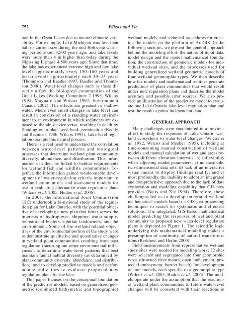
solutions. The integrated, GIS-based mathematical<br />
model predicting the responses of wetland plant<br />
community <strong>to</strong> proposed new water-level regulation<br />
plans is depicted in Figure 1. The scientific logic<br />
underlying this mathematical modeling makes a<br />
presumption of continuity of natural transformations<br />
(Berkhout and Hertin 2000).<br />
Field measurements from representative wetland<br />
study sites were needed for modeling work; 32 sites<br />
were selected and segregated in<strong>to</strong> four geomorphic<br />
types (drowned river mouth, open embayment, protected<br />
embayment, barrier beach) for development<br />
of four models, each specific <strong>to</strong> a geomorphic type<br />
(Wilcox et al. 2005, Hudon et al. 2006). The models<br />
operate under the assumption that the reactions<br />
of wetland plant communities <strong>to</strong> future water-level<br />
changes will be consistent with their reactions in