creating environmental improvements through biodiversity
creating environmental improvements through biodiversity
creating environmental improvements through biodiversity

You also want an ePaper? Increase the reach of your titles
YUMPU automatically turns print PDFs into web optimized ePapers that Google loves.
sites. Downloads have been recorded from the mineral industry, planning officers, and <strong>environmental</strong> officers<br />
in France.<br />
Distribution formats:<br />
• Web download – WSCC website, SxBP website, GoodQuarry.com (Leicester University)<br />
- CD (100)<br />
• Hard copy (700 as 350 in WSCC format and 350 in SxBP format all bar a few were circulated directly to<br />
the above groups)<br />
Media:<br />
• Local radio interview<br />
• Press release<br />
• Articles in SxBP newsletter<br />
• Article/report for MIRO publications<br />
• Members Information Service (WSCC councillors)<br />
• Publicised <strong>through</strong> Association of Local Government Ecologists<br />
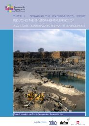
ENVIRONMENTAL AND ECONOMIC INFORMATION FOR AGGREGATES<br />
PROVISION (BGS, DEFRA, MIRO MIST)<br />
EJ Steadman, FM McEvoy, KA Linley, PD Bell, EJ Bee, EL Bartlett, A Napier and J Forster. 2005<br />
Sustainable Aggregates Creating Environmental Improvements <strong>through</strong> Biodiversity<br />
Project Type: Compilation of datasets into GIS<br />
Site: East Midlands<br />
Project Aim: To provide an interactive ‘tool’ or information system for the minerals industry, land-use<br />
planners and other stakeholders to use when considering options for future aggregate provision<br />
Main Methods:<br />
Compiling data on <strong>environmental</strong>, economic and social factors into one data set.<br />
Phase 1 (previous project)– developing <strong>environmental</strong> sensitivity maps for use in SEA<br />
Phase 2- making this available online, along with data on aggregate resources and technical specifications<br />
Output:<br />
An online GIS to access the East Midlands Region <strong>environmental</strong> sensitivity map (from previous project)<br />
Desktop GIS version of the data<br />
Aggregate end-use suitability maps for the East Midlands (actual use of minerals)<br />
Stakeholder consultation exercise and dissemination seminars<br />
Impacts (Potential):<br />
The mapped locations of minerals in relation to <strong>environmental</strong>ly sensitive areas may help in the pre-planning/<br />
planning stages of considering restoration for <strong>biodiversity</strong><br />
Potential expansion:<br />
Environmental sensitivity mapping was to be carried out for the whole of England by BGS, and made<br />
available online by region - new datasets could be added to this layer as they became available. A minerals<br />
GIS for England was to be completed by December 2005. Research into end-use suitability maps was to be<br />
continued by BGS under its Minerals programme.<br />
Dissemination:<br />
Informal meetings, telephone discussions and formal seminars were held with stakeholders to provide<br />
87