Schedule 1: Housing Development - Islington Council
Schedule 1: Housing Development - Islington Council
Schedule 1: Housing Development - Islington Council

You also want an ePaper? Increase the reach of your titles
YUMPU automatically turns print PDFs into web optimized ePapers that Google loves.
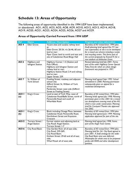
<strong>Schedule</strong> 13: Areas of Opportunity<br />
The following areas of opportunity identified in the 1994 UDP have been implemented,<br />
or abandoned: AO1, AO2, AO3, AO5, AO8, AO9, AO10, AO12, AO13, AO14, AO18,<br />
AO19, AO20, AO21, AO23, AO24, AO25, AO26, AO27 and AO29.<br />
Areas of Opportunity Carried Forward from 1994 UDP<br />
Ref Name Address / Description Progress and other information<br />
AO 4 Eden Grove Vacant sites and surplus railway land<br />
at:<br />
Eden Grove: 20-24, r/o 26-46, 60 and<br />
land at rear;<br />
Piper Close: land to north and east and<br />
site of Caledonian Road Bingo Hall<br />
Boundary of AO revised from 1994 plan.<br />
Draft planning brief agreed Dec 97, but<br />
now superseded, as site is to be developed<br />
for a mixed use scheme including a waste<br />
and recycling centre. This forms part of<br />
the current proposals by Arsenal FC for a<br />
AO 6<br />
AO 7<br />
AO11<br />
(a)<br />
AO11<br />
(b)<br />
Highbury and<br />
<strong>Islington</strong> Station<br />
St. William of<br />
York School<br />
King’s Cross<br />
King’s Cross<br />
AO15 Torrens Street /<br />
Angel Station<br />
Highbury Corner: 1-5 (Station and<br />
Post Office);<br />
Highbury and <strong>Islington</strong> Station and<br />
railway land at rear;<br />
Highbury Station Road: 2-4 and railway<br />
land at rear;<br />
Upper Street: 259<br />
Freeling Street: roadway and adjacent<br />
school site;<br />
Gifford Street: St. William of York<br />
school site;<br />
Pembroke Street: west side (Gifford<br />
Street to Freeling Street)<br />
Land to east of York Way, west of<br />
Caledonian Road/Balfe Street, north of<br />
Pentonville Road and south of<br />
Wharfdale Road<br />
Block including Omega Place, between<br />
Caledonian Road; Pentonville Road,<br />
Northdown Street and Keystone<br />
Crescent<br />
Former station and adjoining land at<br />
City Road: Angel Station;<br />
Torrens Street: 1-7<br />
AO16 City Road Basin City Garden Row: all of east side;<br />
City Road: 259-269;<br />
City Road Basin;<br />
Graham Street: 29-65 and all of east<br />
side;<br />
Wharf Road: all of west side<br />
new stadium at Ashburton Grove.<br />
Revised planning brief July 2001. Forms<br />
part of the wider Highbury Corner Special<br />
Policy Area for which an urban design<br />
framework was prepared in 1997.<br />
Planning brief agreed Sept 1992. School<br />
demolished in 2000. Planning permission<br />
subsequently given on appeal for a<br />
residential development.<br />
Boundary of AO revised from 1994 plan.<br />
Planning briefs agreed July 1998. Planning<br />
permission given in Dec 2001 for a mixed<br />
use development covering most of the AO,<br />
which is now under construction. Planning<br />
brief for Courtyard Theatre site approved<br />
Oct 2002.<br />
Boundary of AO revised from 1994 plan.<br />
Planning brief agreed June 1999. Planning<br />
application approved for part of the site.<br />
Planning brief agreed Jan 1998. Forms<br />
part of the Angel Town Centre.<br />
Boundary of AO revised from 1994 plan.<br />
Planning brief for 261 City Road agreed in<br />
June 2001. A draft strategy for the wider<br />
City Road Basin area was deferred.<br />
Masterplan for whole area to be prepared<br />
jointly with BWB and other development<br />
partners.