Schedule 1: Housing Development - Islington Council
Schedule 1: Housing Development - Islington Council
Schedule 1: Housing Development - Islington Council

You also want an ePaper? Increase the reach of your titles
YUMPU automatically turns print PDFs into web optimized ePapers that Google loves.
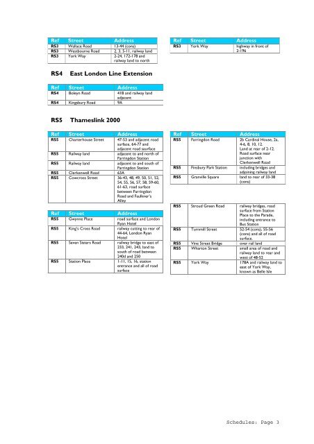
Ref Street Address<br />
RS3 Wallace Road 13-44 (cons)<br />
RS3 Westbourne Road 2, 3, 5-11, railway land<br />
RS3 York Way 2-24, 172-178 and<br />
railway land to north<br />
Ref Street Address<br />
RS3 York Way highway in front of<br />
2-196<br />
RS4<br />
East London Line Extension<br />
Ref Street Address<br />
RS4 Boleyn Road 41B and railway land<br />
adjacent<br />
RS4 Kingsbury Road 9A<br />
RS5 Thameslink 2000<br />
Ref Street Address<br />
RS5 Charterhouse Street 47-53 and adjacent road<br />
surface, 64-77 and<br />
adjacent road saurface<br />
RS5 Railway land adjacent to and north of<br />
Farringdon Station<br />
RS5 Railway land adjacent to and south of<br />
Farringdon Station<br />
RS5 Clerkenwell Road 63A<br />
RS5 Cowcross Street 36-43, 48, 49, 50, 51, 52,<br />
54, 55, 56, 57, 58, 59-60,<br />
61-63, road surface<br />
between Farringdon<br />
Road and Faulkner’s<br />
Alley<br />
Ref Street Address<br />
RS5 Gwynne Place road surface and London<br />
Ryan Hotel<br />
RS5 King’s Cross Road railway cutting to rear of<br />
44-64, London Ryan<br />
Hotel<br />
RS5 Seven Sisters Road railway bridge to east of<br />
233, 241, 243, land to<br />
south of road between<br />
240d and 250<br />
RS5 Station Place 1-11, 15, 16, station<br />
entrance and all of road<br />
surface<br />
Ref Street Address<br />
RS5 Farringdon Road 2b Cardinal House, 2a,<br />
4-6, 8, 10, 12.<br />
Land at rear of 2-12.<br />
Road surface near<br />
junction with<br />
Clerkenwell Road<br />
RS5 Finsbury Park Station including bridges and<br />
adjoining railway land<br />
RS5 Granville Square land to rear of 33-38<br />
(cons)<br />
RS5 Stroud Green Road railway bridges, road<br />
surface from Station<br />
Place to the Parade,<br />
including entrance to<br />
Bus Station<br />
RS5 Turnmill Street 52-54 (cons), 55-56<br />
(cons) and all of road<br />
surface.<br />
RS5 Vine Street Bridge over rail land<br />
RS5 Wharton Street small area of road and<br />
railway land to rear and<br />
west of 48-52<br />
RS5 York Way 178A and railway land to<br />
east of York Way,<br />
known as Belle Isle<br />
<strong>Schedule</strong>s: Page 3