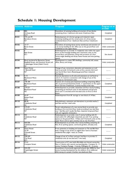
Schedule 1: Housing Development - Islington Council
Schedule 1: Housing Development - Islington Council
Schedule 1: Housing Development - Islington Council

Create successful ePaper yourself
Turn your PDF publications into a flip-book with our unique Google optimized e-Paper software.
<strong>Schedule</strong> 1: <strong>Housing</strong> <strong>Development</strong><br />
Scheme Address Proposal Progress as at<br />
31/3/03<br />
H100 88A<br />
Demolition of existing building and erection of two blocks<br />
Archway Road<br />
containing three 1-bedroom and seven 2-bedroom flats.<br />
Completed<br />
N19<br />
H101 37A and 39<br />
Redevelopment of a former garage and industrial repair<br />
Barnsbury Grove<br />
N7<br />
workshop building and the construction of a three storey<br />
residential block of six 1-bedroom flats and four 2-bedroom<br />
flats.<br />
Completed<br />
H102 13-17<br />
Baron Street<br />
N1<br />
H103 6<br />
Bath Street<br />
EC1<br />
H104<br />
H105<br />
Block bordered by Bemerton Street,<br />
Bingfield Street, and Havelock Street and<br />
Copenhagen Street (Naish Court)<br />
N1<br />
Apex House<br />
1 Benwell Road<br />
N7<br />
H106 3-14<br />
Blackstock Mews<br />
N4<br />
H107 178-184<br />
Blackstock Road<br />
N5<br />
H108 219-221<br />
Blackstock Road<br />
N5<br />
H109 43-47<br />
Boleyn Road<br />
N16<br />
H110 88-96<br />
Caledonian Road<br />
N1<br />
H111 419-421<br />
Caledonian Road<br />
N7<br />
H112 455<br />
Caledonian Road<br />
N7<br />
H113 500-506<br />
Caledonian Road<br />
N7<br />
H114 Diana House<br />
33-34<br />
Chiswell Street<br />
EC1<br />
H115 238-240<br />
City Road<br />
EC1<br />
H116 57-61<br />
Compton Street<br />
H117 224-230<br />
Copenhagen Street<br />
N1<br />
Demolition of existing three storey warehouse and erection of<br />
a six storey building for B1 office use on the ground floor and<br />
residential on the upper floors.<br />
Redevelopment to provide 12 residential units within the upper<br />
floors of the frontage building and 2 live/work units on the<br />
ground floor and basement, along with provision of a four<br />
storey single dwelling and three mews houses and nine parking<br />
spaces.<br />
<strong>Development</strong> to create 300 dwellings, community hall, estate<br />
office, library and shops.<br />
Change of use, conversion, alteration and extension at roof<br />
level to provide 16 live/work units at first, second, third and<br />
new fourth floor level. (Retaining ground floor industrial<br />
floorspace).<br />
External alterations to all units and extension at roof level to<br />
units 3, 4, 5 and 6 in connection with change of use of the<br />
premises to 16 live/work units.<br />
Erection of a 5 storey plus basement building comprising offices<br />
(B1) at ground and basement levels, 11 apartments on the upper<br />
floors and two 2-bedroom, 2 storey houses at the rear.<br />
Redevelopment to provide a basement and four storey building<br />
comprising six live/work units on the basement and ground<br />
floors and 12 one-bed and 6 two-bed units on first to third<br />
floors.<br />
Redevelopment from B1 storage to new block of 14 flats.<br />
Refurbishment, extension and alterations to provide twelve 2<br />
bed flats and four retail units.<br />
Partial redevelopment of a two storey block to provide new<br />
building at first and third floor levels providing 6 two bed flats,<br />
one 1 bed flat and 5 studio flat flats, retention of ground floor<br />
café and vegetable wholesalers.<br />
Redevelopment to provide a new 5 storey building with A1<br />
retail and/or B1 (office/light industrial) use with 4 car parking<br />
spaces on the ground floor, 14 flats and 4 live/work units on the<br />
upper floors and an open amenity area at rear first floor.<br />
Redevelopment to provide a four storey building containing 32<br />
flats, 8 car parking spaces, communal gardens, and play area.<br />
Front extension to building and extension at 7th and 8th floor<br />
level. Change of use of first to eighth floor level to fourteen<br />
residential flats (eight 1-bed, six 2-bed).<br />
Change of use of 1st floor and part 2nd floor to provide 13<br />
residential units (6 one bed and 7 two bed).<br />
Construction of 57 new build affordable and shared ownership<br />
flats in 3 blocks with central courtyard/graden. Compton St - 4<br />
storey, Compton Passage - 3 storey, Dallington St - 6 storey.<br />
Amendment of previously approved scheme (Jan 2000) for four<br />
storey housing development by the addition of an additional<br />
(4th) storey to contain 2 further two-bedroom flats.<br />
Under construction<br />
Site cleared<br />
Under construction<br />
_____<br />
_____<br />
Completed<br />
_____<br />
Completed<br />
Completed<br />
_____<br />
_____<br />
Completed<br />
_____<br />
Completed<br />
Under construction<br />
Under construction
Scheme Address Proposal Progress as at<br />
31/3/03<br />
H118 10<br />
Renewal of outline permission (ref 951642) for residential<br />
Corsica Street<br />
N5<br />
development to provide 24 habitable rooms in a part two/part<br />
three storey development.<br />
_____<br />
H119<br />
The Birbeck Tavern<br />
Courtauld Road<br />
N19<br />
H120 36-38<br />
Drayton Park<br />
N5<br />
H121 64<br />
Eden Grove<br />
N7<br />
H122 6A and part 42<br />
Elthorne Road<br />
N19<br />
H123 15<br />
Garrett Street<br />
EC1<br />
H124 272-274<br />
Goswell Road<br />
EC1V<br />
H125<br />
Congregational Church<br />
Highbury Quadrant<br />
N5<br />
H126 619-639<br />
Holloway Road<br />
N19<br />
H127 643-645<br />
Holloway Road<br />
N19<br />
H128 60-76<br />
Ironmonger Row<br />
EC1<br />
H129 Culford House<br />
50 King Henry's Walk<br />
N1<br />
H130 The Wellington Public House<br />
21-25<br />
Lever Street<br />
EC1<br />
H131 412<br />
Liverpool Road<br />
N7<br />
H132 555<br />
Liverpool Road<br />
N7<br />
H133 19<br />
Manor Gardens<br />
N7<br />
H134 34-39<br />
Margery Street<br />
WC1<br />
H135 14-18<br />
Market Road<br />
N7<br />
H136<br />
H137<br />
Marquess Estate<br />
Clephane Road<br />
N1<br />
Marquess Estate<br />
1-9 Ramsey Walk<br />
N1<br />
Conversion of public house including roof extension and<br />
construction of a four storey building to provide a total of 15<br />
residential units.<br />
Part demolition, extension and construction of new single<br />
storey buildings at rear and conversion to provide B1 floorspace<br />
on the ground floor and part 1st floor and residential on the<br />
remaining 1st, 2nd, 3rd and 4th floors, and associated parking.<br />
Change of use and roof extension to the former school building<br />
to provide 10 residential units.<br />
Demolition of exisiting warehouse to create 9x3 bed and 8x2<br />
bed houses with 13 car parking spaces and play area.<br />
Redevelopment to provide a part 2-storey and part 3-storey<br />
building for residential use (2x1 bed maisonettes, 4x1 bed flats,<br />
4x2 bed maisonettes) and 8 off-street parking spaces.<br />
Redevelopment of existing 3 storey buildings in mixed use to<br />
provide a 6 storey building comprising 2 ground floor A1 units,<br />
1 B1 unit and 5 upper floors of 12 one bed flats, and 2 two bed<br />
flats.<br />
Part demolition of existing church and church buildings, erection<br />
of four storey extension to the church to form new church hall,<br />
new church social and educational building with a block of 14<br />
flats and one caretakers flat (15 total).<br />
Conversion of existing second and third floors to create nine 2-<br />
b/r self-contained flats and the creation of an additional storey<br />
above the existing first floor at the southern end of the building<br />
to provide three 2-b/r self contained flats.<br />
Demolition of ballroom, redevelopment and conversion of<br />
retained part of premises to provide a restaurant, a retail unit<br />
and 27 residential units for social housing.<br />
Conversion of a former commercial building to provide 12 two<br />
bed flats and 2 three bed flats on exisitng first to third floor and<br />
within proposed roof extension at fourth floor, B1 units at<br />
ground floor and basement, off street parking, cycle, bin storage.<br />
Erection of two 3-storey blocks to provide fifteen residential<br />
units.<br />
Redevelopment of a two storey public house to provide a six<br />
storey residential block for thirteen-2 b/r flats and one-1 b/r flat.<br />
Redevelopment of a former public house and construction of a<br />
five storey residential block providing ten 2- bedroom flats.<br />
Erection of part one storey, part three storey and part five<br />
storey building with retail (A1) or office (A2 or B1) space at<br />
ground floor and with 13 two bedroom flats and one three<br />
bedroom flat on upper floors. No car parking is proposed.<br />
Demolition of existing pitta bakery and erection of a 4-storey<br />
block of 14 flats.<br />
Demolition of warehouse and erection of part 4/5/6 storey<br />
building to provide commercial floorspace, a doctors surgery, a<br />
school extension and 43 flats above.<br />
Erection of a part four, part five storey block of 14 twobedroom<br />
flats and 4 one-bedroom flats being a variation of part<br />
of scheme approved 16th June 1999 for 32 dwellings (Ref:<br />
990364).<br />
Redevelopment of sites P3 (vacant C3 and D1 use) and P4 (D2<br />
open space use) to provide fifteen 1-bedroom flats, fifty six 2-<br />
bedroom flats, five 3-bedroom houses and three 4-bedroom<br />
houses.<br />
Erection of a 3,4 and 5 storey terraced block to comprise 12<br />
houses and 18 flats.<br />
Completed<br />
_____<br />
_____<br />
Completed<br />
_____<br />
_____<br />
_____<br />
Partly<br />
completed<br />
_____<br />
Under construction<br />
Under construction<br />
Under construction<br />
Under construction<br />
Under construction<br />
Completed<br />
Completed<br />
_____<br />
Completed<br />
Under construction
Scheme Address Proposal Progress as at<br />
31/3/03<br />
H138 272-280<br />
Erection of a five storey building comprising 2 units to be<br />
New North Road<br />
N1<br />
occupied by A1, A2, A3 or B1 at ground level and residential on<br />
upper floors of 11 two bedrooms and 3 one bedrooms.<br />
Under construction<br />
H139 50-56<br />
Penton Street<br />
N1<br />
H140<br />
George IV Public House<br />
156 Pentonville Road<br />
N1<br />
H141 173<br />
New River Head<br />
Rosebery Avenue<br />
EC1<br />
H142 1<br />
Rufford Street<br />
N1<br />
H143 250-252<br />
Seven Sisters Road<br />
N4<br />
H144 31<br />
Seward Street<br />
EC1<br />
H145 33<br />
Seward Street<br />
EC1<br />
H146 39<br />
Southgate Road<br />
N1<br />
H147 81-83<br />
Southgate Road<br />
N1<br />
H148 235-243<br />
Sussex Way<br />
N19<br />
H149 39-47<br />
Wedmore Street<br />
N19<br />
H150 The Market Tavern Public House<br />
144 York Way<br />
N1<br />
Redevelopment and extension of existing buildings to provide<br />
two commercial units at ground floor for A1, A2, A3, B1* and<br />
ten residential units.<br />
Redevelopment as a basement and five storey apartment<br />
building with Class A3 bar/restaurant in the front part of the<br />
ground floor and the entire basement, a wheelchair accessible<br />
flat on the ground floor, nine 1-bedroom flats and 2-bed<br />
penthouse.<br />
Conversion of workshop in Hardwick Street to 8 flats (Block<br />
A). New building in corner of Hardwick/Amwell Streets for 39<br />
flats and 15 parking spaces at rear (Block B). New building<br />
adjacent former Lab Building for 42 flats with basement parking<br />
(Block C).<br />
Redevelopment for 22 live/work units and 2 x B1 office units.<br />
Erection of a five storey building consisting of a shop unit on the<br />
ground floor and 18 one-bedroom flats above.<br />
Redevelopment and change of use to provide four 1-bedroom<br />
flats and seven 2-bedroom flats within a six storey building.<br />
Modifications to PP002685 for construction of 10 residential<br />
units and one live/work unit within a 6 storey development.<br />
Demolition of exisitng warehouse and erection of five 2 bed<br />
houses and seven 2 bed flats.<br />
Conversion of front building from bedsits into six flats (four 1-<br />
bedroom, two 2-bedroom) and the change of use and<br />
conversion of two factory warehouse buildings into four flats<br />
(two 2-bedroom live/work units and two 1-bedroom flats).<br />
Redevelopment from warehouse (B2) to provide a four storey<br />
building consisting of thirteen flats (four 3-bedroom, six 2-<br />
bedroom and three 1-bedroom units) and A3 use.<br />
Redevelopment to provide 8 flats and 6 houses.<br />
Redevelopment to provide a basement and part five, part six<br />
storey building comprising a commercial unit to ground floor<br />
and basement (A1/2/3 or B1 use), with 14 flats on upper floors<br />
(3 studios, three 1-b/r, six 2-b/r and two 3-b/r).<br />
_____<br />
Under construction<br />
Completed<br />
Under construction<br />
Completed<br />
Under construction<br />
Under construction<br />
Under construction<br />
Completed<br />
Under construction<br />
Completed<br />
Under construction
<strong>Schedule</strong> 2: Employment <strong>Development</strong><br />
Scheme Address Proposal Progress as at<br />
31/3/03<br />
E100 8-13<br />
Redevelopment to provide new 8-storey office building.<br />
Chiswell Street<br />
_____<br />
EC1<br />
E101 Oliver House<br />
Demolition of existing building and construction of a four storey<br />
51-53<br />
office building.<br />
_____<br />
City Road<br />
EC1<br />
E102 Sun Court House<br />
Creation of a new office entrance to serve existing offices on<br />
18-26<br />
Essex Road<br />
N1<br />
first to fifth floors and the extension of rooftop pavilions and<br />
provision of terraces (amendments and alterations to<br />
PP992018).<br />
_____<br />
E103 1-2<br />
Finsbury Square<br />
EC2<br />
E104<br />
29_ & 30A<br />
Great Sutton Street<br />
EC1<br />
E105 443-445<br />
Holloway Road<br />
N7<br />
E106 18-30<br />
Leonard Street<br />
EC2<br />
E107 250-254<br />
Old Street<br />
EC1<br />
E108 11-21<br />
Paul Street<br />
EC2<br />
E109 4-14<br />
Tabernacle Street<br />
EC2<br />
E110 66<br />
Turnmill Street<br />
EC1<br />
E111 17-23<br />
Vale Royal<br />
N7<br />
E112 90-92<br />
White Lion Street<br />
N1<br />
E113 62-68<br />
York Way<br />
N7<br />
E114 196-200<br />
York Way<br />
N7<br />
The redevelopment of an existing nine storey banking hall and<br />
office building to provide an eight storey building with A1, A2 or<br />
A3 use at ground floor level and B1 office use at first to seventh<br />
floor levels.<br />
Redevelopment of a former dairy and adjacent stable block to<br />
provide a part four/part five storey photographic studio<br />
complex and incorporating 8 studio spaces, offices and servicing<br />
together with a ground floor restaurant with kitchen and<br />
storage.<br />
Change of use of the property to business (B1) use.<br />
Redevelopment of a vacant site (temporary car park) for a six<br />
storey plus basement building for B1 use.<br />
Renewal of PP 920520 for the erection of new eight story office<br />
building.<br />
Refurbishment, recladding and extension of existing premises<br />
(use B1a) including a two storey roof extension.<br />
Redevelopment of existing B1 (office) building to provide a<br />
basement and six storey B1 office building (approximately<br />
3,500sq.m).<br />
Demolition of existing building retaining Turnmill Street and<br />
Broad Yard facades and erection of a 6 storey office building<br />
and new shopfront and entrance.<br />
Erection of a single storey building for B1, B2 or B8 uses<br />
together with a two storey ancilliary office.<br />
Renewal of unimplemented permission (ref: 940140) for<br />
redevelopment by the erection of a five storey office building,<br />
granted on 8 th August 1994.<br />
Redevelopment of site (warehouse and car wash) to provide a<br />
building (three to four storeys in height) for any use within B1<br />
use class.<br />
Renewal of planning permission dated March 1996 (951919) for<br />
redevelopment to provide a basement and a five storey building<br />
for Class B1 business use.<br />
Under construction<br />
_____<br />
_____<br />
_____<br />
_____<br />
_____<br />
_____<br />
_____<br />
Under construction<br />
_____<br />
_____<br />
_____
<strong>Schedule</strong> 3: Transport<br />
1] Roads shown on the Proposals Map<br />
Greater London Road Network<br />
Archway Interchange<br />
Archway Road<br />
Baron Street (South of White Lion Street)<br />
Camden Road<br />
City Road (North of Old Street Roundabout)<br />
Farringdon Road<br />
Goswell Road (Angel Junction - Wakley Street)<br />
Highbury Corner Roundabout<br />
Holloway Road<br />
Isledon Road<br />
<strong>Islington</strong> High Street<br />
King's Cross Road<br />
Old Street (East of Old Street Roundabout)<br />
Old Street Roundabout<br />
Parkhurst Road<br />
Penton Rise<br />
Pentonville Road<br />
Seven Sisters Road<br />
Tollington Road<br />
Upper Street<br />
Wakley Street<br />
White Lion Street (East of Baron Street)<br />
(Parts of Archway Road, St John's Way,<br />
Sandridge Street, Holloway Road, Highgate Hill<br />
and Tollhouse Way)<br />
Borough Distributor Roads<br />
Balls Pond Road<br />
Blackstock Road<br />
Brecknock Road<br />
Caledonian Road<br />
Canonbury Road<br />
City Road (South of Old Street Roundabout)<br />
Clerkenwell Road<br />
Crouch Hill<br />
Essex Road<br />
Goswell Road (South of Wakley Street)<br />
Green Lanes<br />
Highbury Grove<br />
Highbury Park<br />
Highgate Hill<br />
Hillmarton Road<br />
Hornsey Rise<br />
Hornsey Road<br />
Junction Road<br />
New North Road<br />
Newington Green<br />
Newington Green Road<br />
Old Street (West of Old Street Roundabout)<br />
Rock Street<br />
Rosebery Avenue<br />
St John Street (North of Rosebery Avenue)<br />
St Paul's Road<br />
St Thomas’s Road (North of Rock Street)<br />
Station Place<br />
Stroud Green Road<br />
Wharfdale Road<br />
York Way<br />
<strong>Schedule</strong>s: Page 1
RS2 Crossrail 2 (Hackney - South West)<br />
Ref Street Address<br />
RS2 Affleck Street all<br />
RS2 Anderson Square all<br />
RS2 Angel Mews all<br />
RS2 Annette Crescent all<br />
RS2 Ashby Grove all<br />
RS2 Astey's Row all<br />
RS2 Balls Pond Road 22-40<br />
RS2 Baron Street 13-17, 2-20<br />
RS2 Baxter Road part, inc Warley House,<br />
Romford House, Ongar<br />
House<br />
RS2 Berners Road 1-6 (cons)<br />
RS2 Britannia Row 1-7, 2A, 2-18<br />
RS2 Burder Road all<br />
RS2 Caledonian Road 1-7, 2-14<br />
RS2 Calshot Street Hales Prior, 4 (Keen<br />
House), 13-35, 6A,<br />
Manneby Prior<br />
RS2 Camden Passage all<br />
RS2 Camden Walk all<br />
RS2 Canonbury Road 1-15, 6-14, Haslam<br />
House<br />
RS2 Canonbury Street all<br />
RS2 Chapel Market 46-55 (cons)<br />
RS2 Charlton Place all<br />
RS2 City Road Angel Square, 415<br />
RS2 Colebrooke Place 1-3<br />
RS2 Colebrooke Row 59-85 (cons) including<br />
Lamb's Mews<br />
RS2 Collier Street part of Priors Estate<br />
RS2 Collins Yard part roadway and east<br />
side<br />
RS2 Cross Street 1-11, 2-14, 1A<br />
RS2 Crowland Terrace all<br />
RS2 Cumming Street all<br />
RS2 Cynthia Street all<br />
RS2 Dagmar Terrace 2-3<br />
RS2 Dibden Street Hayhurst (part) and<br />
roadway<br />
RS2 Donegal Street Penton House, Car<br />
Pound<br />
RS2 Donegal Street Prospect House (r/o<br />
site) & Rodney House<br />
(r/o site)<br />
RS2 Draper Place all<br />
RS2 Duncan Street all, except 6-24<br />
RS2 Duncan Terrace 50-64 (cons), and<br />
gardens at front of 46-64<br />
RS2 Elder Walk car park adj 1 Elder<br />
Walk<br />
RS2 Elliott's Place all<br />
RS2 Elmore Street 128, 130, 138-142<br />
RS2 Englefield Road 102-144,129-155<br />
RS2 Essex Road 1-181, 2-196<br />
RS2 Essex Road 207, 198-350, 321<br />
RS2 Essex Road Eric Fletcher Court,<br />
Ashby House, Doctor's<br />
Surgery<br />
RS2 Essex Road Skomer Walk (part),<br />
Upper Sheppy Walk<br />
(part)<br />
RS2 Gaskin Street 18, 31-33<br />
RS2 Gateway Arcade all<br />
RS2 Greenhills Terrace 1-12 (cons), 25-30<br />
(cons)<br />
RS2 Greenman Street 5-9 and public open<br />
space (Tibby Place)<br />
RS2 Halliford Street 68<br />
RS2 Halton Cross Street all<br />
RS2 Halton Road 8-18, Fircroft<br />
Ref Street Address<br />
RS2 Hermes Street all<br />
RS2 Horse Yard all<br />
RS2 <strong>Islington</strong> Green 7-39, Gardens<br />
RS2 <strong>Islington</strong> High Street all except 1-5<br />
RS2 Killick Street 2, Stuart Mill House<br />
RS2 King's Cross Road 188<br />
RS2 Kingsland Green all<br />
RS2 Kingsland Passage all<br />
RS2 Lamb's Mews all<br />
RS2 Laundry Lane 1-4 (cons)<br />
RS2 Layton Road 11, and car park<br />
RS2 Liverpool Road 1-11, 2-28, and adjoining<br />
car park<br />
RS2 Melville Place all<br />
RS2 Mitchison Road 27-53, playground<br />
RS2 New North Road 320-334, 399<br />
RS2 New River Walk Astey's Row to<br />
Canonbury Road<br />
RS2 Northampton Street Horsefield House,<br />
RS2 Northchurch Road 144-154A, 175-191<br />
RS2 Northdown Street 1-25, 2-22, Pollard<br />
House<br />
RS2 Oakley Road 71-79<br />
RS2 Ockendon Mews 2-10 (cons)<br />
RS2 Ockendon Road 17-63, 40-92<br />
RS2 Omega Place all<br />
RS2 Packington Street 160-162 (cons)<br />
RS2 Parkfield Street Car park, and all other<br />
properties except 20<br />
and 30-32<br />
RS2 Penton Grove all<br />
RS2 Penton Street 1-15 , 10-30<br />
RS2 Penton Street Public Carriage Office<br />
and Car Pound<br />
RS2 Pentonville Road 14-54, 247-251, 60-300<br />
RS2 Pentonville Road former St James's<br />
Church<br />
RS2 Pentonville Road Joseph Grimaldi Park<br />
and adjoining playground<br />
RS2 Pentonville Road Kings Cross House<br />
RS2 Pickering Street Hayhurst, 1a, Garages<br />
RS2 Pierrepont Arcade all<br />
RS2 Pierrepont Row all<br />
RS2 Pleasant Place all including gardens<br />
RS2 Popham Street 19, 20, 21<br />
RS2 Providence Row all<br />
RS2 Queen's Head Street Raleigh Mews (part)<br />
RS2 Raleigh Mews 1-18, 20, 21, 23, 24, 26,<br />
27<br />
RS2 River Place 1-7<br />
RS2 Rodney Street 2-8, Rodney House<br />
RS2 Southgate Road 175-205<br />
RS2 St. Mary's Path part roadway<br />
RS2 St. Peter's Street 1<br />
RS2 Torrens Street west side (Angel Square)<br />
RS2 Upper Street 1-49 (cons), 334-359<br />
(cons)<br />
RS2 Wall Street 50-54, 56<br />
RS2 White Lion Street 9-54 (cons), 90-101<br />
(cons)<br />
RS2 White Lion Street Youth Centre, United<br />
Reform Church<br />
RS2 Windsor Street Gough House<br />
RS2 Wontner Close 1-8 (cons)<br />
RS2 York Way 2-18
RS3<br />
Channel Tunnel Rail Link<br />
Ref Street Address<br />
RS3 Arundel Place 1-3 (cons), 6-10 (cons)<br />
and railway land<br />
RS3 Arundel Square 13-17 (cons), 38-42<br />
(cons)<br />
RS3 Arundel Square gardens and railway<br />
land<br />
RS3 Assata Mews 1-14<br />
RS3 Ball's Pond Road Kerridge Court<br />
RS3 Barnsbury Grove all including railway<br />
land<br />
RS3 Blair Close 10<br />
RS3 Blundell Street 53<br />
RS3 Boleyn Road 41b, 43-47, railway<br />
land<br />
RS3 Burder Close 1A (Public open space)<br />
RS3 Calabria Road 18-50 inc railway land<br />
at rear<br />
RS3 Caledonia Street 2-4, 8, 10<br />
RS3 Caledonian Road 1-7 and roadway at<br />
front<br />
RS3 Caledonian Road 351A, 351, 400, railway<br />
bridge, 400A, 402A,<br />
402<br />
RS3 Caledonian Road highway in front of<br />
341-361<br />
RS3 Caledonian Road highway in front of<br />
363-367<br />
RS3 Caledonian Road highway in front of<br />
388-400<br />
RS3 Caledonian Road Old Forge Business<br />
Centre (r/o 7)<br />
RS3 Centurion Close 43-47, estate amenity<br />
space and adjoining<br />
railway land, 109, 110<br />
RS3 Conistone Way 138 and railway land to<br />
rear of 132-138<br />
RS3 Cornelia Street 2-34, Alderwick Court<br />
RS3 Corsica Street 1a, 1-7, 2-10,<br />
electricity sub station,<br />
railway land,<br />
RS3 Court Gardens 1-10 (cons), 26-31<br />
(cons)<br />
RS3 Crane Grove 45<br />
RS3 Gifford Street 60 (inc railway land at<br />
r/o 60 & 66-112), 90,<br />
98, 102<br />
RS3 Granary Square 1-8 (cons)<br />
RS3 Grosvenor Avenue 1-71, 75, 83-85,<br />
Canonbury Station<br />
RS3 Grosvenor Avenue 123-151, railway land<br />
at rear<br />
RS3 Hadrian Mews 1-3 (cons)<br />
RS3 Harecourt Road 8-10 (cons), 17-22<br />
(cons), 28-29<br />
RS3 Harecourt Road railway land at rear<br />
RS3 Highbury Coal Yard all<br />
RS3 Highbury Corner 17, Post Office, 2-10<br />
RS3 Highbury Corner Highbury & <strong>Islington</strong><br />
Station<br />
RS3 Highbury Corner Salisbury House,<br />
Highbury Station<br />
Parade<br />
RS3 Highbury Grove 1-5, and adjoining<br />
railway land<br />
RS3 Highbury Grove Highbury Grove Court<br />
and adjoining railway<br />
land<br />
RS3 Highbury New Park 10-22, Sinclair Court,<br />
railway land to south<br />
RS3 Highbury Place 1-6 (cons), railway land<br />
to south<br />
RS3 Highbury Place War Memorial<br />
Ref Street Address<br />
(Highbury Fields)<br />
RS3 Highbury Station Road 2-4, 1-7, 41-167,<br />
railway land<br />
RS3 Hope Close 4-7 (cons)<br />
RS3 King Henry's Walk 50-58,Tudor Court,<br />
railway land<br />
RS3 King Henry's Walk St Judes and St Pauls<br />
Primary School<br />
RS3 Kingsbury Road Jewish Burial Ground,<br />
Works<br />
RS3 Kingsbury Terrace railway land<br />
RS3 Liverpool Road 300, 302, 302A, 304,<br />
Starliner Court<br />
RS3 Liverpool Road Granary Square, 387-<br />
393, railway land<br />
RS3 Lyon Street land to r/o <strong>Council</strong><br />
offices<br />
RS3 Mildmay Grove North 33-111, Mildmay<br />
Court, St Judes and St<br />
Pauls Church<br />
RS3 Mildmay Grove North railway land<br />
RS3 Mildmay Grove South 2A, 2-106, railway land<br />
RS3 Mildmay Park 43-49, Mildmay Court,<br />
36, 38-44<br />
RS3 Newington Green<br />
Road<br />
railway land, 59-81, 78-<br />
88<br />
RS3 Northampton Grove 1, 2-15a (cons), 16-19<br />
(cons), Floral Place<br />
RS3 Northampton Park 2-24, 2b, 2c, Stanton<br />
Lodge<br />
RS3 Offord Road 29A, 31-79, 85-105,<br />
135-169<br />
RS3 Offord Street 1-5<br />
RS3 Orleston Mews 12, 14<br />
RS3 Outram Place 21A<br />
RS3 Pentonville Road 278-300<br />
RS3 Regent's Canal 1 (Maiden Lane Bridge)<br />
RS3 Roman Way 1a, 2a, 1-5 (cons), 149,<br />
151, 152, 153<br />
RS3 Roman Way Caledonian Industrial<br />
Estate (149), railway<br />
land<br />
RS3 Rufford Street part of road<br />
carriageway<br />
RS3 Rufford Street railway land at j/w<br />
York Way and part of<br />
highway, 1A<br />
RS3 St. Clement Street 4, 5, 7-11 (cons),<br />
Montague Court<br />
RS3 St. Jude Street 2-14, 48-58 and railway<br />
land to rear<br />
RS3 St. Jude Street open space adjoining<br />
48, and railway land to<br />
rear, 58B<br />
RS3 St. Paul's Road 154-210, 222A, 222B,<br />
226-272, 274A, 274B,<br />
274C<br />
RS3 St. Paul's Road 290A, 302-324<br />
RS3 St. Paul's Road railway land to rear<br />
RS3 St. Paul's Road warehouse and<br />
builders yard to r/o<br />
276-306<br />
RS3 Tileyard Road Car park at r/o 25-41<br />
King's Exchange (25A)<br />
RS3 Tileyard Road railway Land (25B)<br />
RS3 Upper Street 251-259 (cons)<br />
RS3 Vale Royal 24-28 and land at r/o<br />
30-40,, 30-40, 42<br />
RS3 Vale Royal entrance to car-park<br />
adj 41 King's Exchange<br />
RS3 Vale Royal road carriageway at j/w<br />
York Way<br />
<strong>Schedule</strong>s: Page 2
Ref Street Address<br />
RS3 Wallace Road 13-44 (cons)<br />
RS3 Westbourne Road 2, 3, 5-11, railway land<br />
RS3 York Way 2-24, 172-178 and<br />
railway land to north<br />
Ref Street Address<br />
RS3 York Way highway in front of<br />
2-196<br />
RS4<br />
East London Line Extension<br />
Ref Street Address<br />
RS4 Boleyn Road 41B and railway land<br />
adjacent<br />
RS4 Kingsbury Road 9A<br />
RS5 Thameslink 2000<br />
Ref Street Address<br />
RS5 Charterhouse Street 47-53 and adjacent road<br />
surface, 64-77 and<br />
adjacent road saurface<br />
RS5 Railway land adjacent to and north of<br />
Farringdon Station<br />
RS5 Railway land adjacent to and south of<br />
Farringdon Station<br />
RS5 Clerkenwell Road 63A<br />
RS5 Cowcross Street 36-43, 48, 49, 50, 51, 52,<br />
54, 55, 56, 57, 58, 59-60,<br />
61-63, road surface<br />
between Farringdon<br />
Road and Faulkner’s<br />
Alley<br />
Ref Street Address<br />
RS5 Gwynne Place road surface and London<br />
Ryan Hotel<br />
RS5 King’s Cross Road railway cutting to rear of<br />
44-64, London Ryan<br />
Hotel<br />
RS5 Seven Sisters Road railway bridge to east of<br />
233, 241, 243, land to<br />
south of road between<br />
240d and 250<br />
RS5 Station Place 1-11, 15, 16, station<br />
entrance and all of road<br />
surface<br />
Ref Street Address<br />
RS5 Farringdon Road 2b Cardinal House, 2a,<br />
4-6, 8, 10, 12.<br />
Land at rear of 2-12.<br />
Road surface near<br />
junction with<br />
Clerkenwell Road<br />
RS5 Finsbury Park Station including bridges and<br />
adjoining railway land<br />
RS5 Granville Square land to rear of 33-38<br />
(cons)<br />
RS5 Stroud Green Road railway bridges, road<br />
surface from Station<br />
Place to the Parade,<br />
including entrance to<br />
Bus Station<br />
RS5 Turnmill Street 52-54 (cons), 55-56<br />
(cons) and all of road<br />
surface.<br />
RS5 Vine Street Bridge over rail land<br />
RS5 Wharton Street small area of road and<br />
railway land to rear and<br />
west of 48-52<br />
RS5 York Way 178A and railway land to<br />
east of York Way,<br />
known as Belle Isle<br />
<strong>Schedule</strong>s: Page 3
4] Improvements to Stations<br />
Scheme Station Proposal Progress as at<br />
31/3/03<br />
T9 Farringdon Thameslink 2000 project to provide new ticket office,<br />
extended and new platforms, new bridges and lifts.<br />
Crossrail project to create station and interchange<br />
Thameslink<br />
programmed for<br />
2003-2005<br />
T10 Finsbury Park Thameslink and East Coast Mainline projects to improve<br />
station<br />
T11 Highbury and <strong>Islington</strong> Redevelopment to include improved access to platforms,<br />
larger ticket hall and concourse area, second entrance<br />
and provision of shops and cafes<br />
T12 King’s Cross Improvements to Underground Station include enlarging<br />
existing and creating new ticket halls, new pedestrian<br />
tunnels<br />
T13 King’s Cross Railway Lands New station on North London Line near York Way to<br />
serve redevelopment of major site<br />
Planning Brief<br />
prepared<br />
Construction<br />
underway<br />
<strong>Schedule</strong>s: Page 4
<strong>Schedule</strong> 4: Recreation & Leisure<br />
Walkways<br />
Scheme Address<br />
Proposal<br />
W1 Parkland Walk Public Open Space/Walkway<br />
W2 <strong>Islington</strong> Park Walk Extension to Parkland Walk using former railway<br />
land as follows:<br />
- Drayton Park, land at r/o west side<br />
- Whistler Street, railway embankment<br />
- St Thomas’ Road, r/o 7-76<br />
- Ronalds Road, adj 70-71<br />
W3 New River Walk Improvements to walkway and link to Clissold<br />
Park, comprising public highway and public open<br />
space in Colebrooke Row, Duncan Terrace, Essex<br />
Road, New River Walk, Petherton Road and<br />
Wallace Road<br />
W4 Regent’s Canal Towpath Walkway<br />
New or Improved Public Open Space<br />
Scheme Address Proposal Progress as at<br />
31/3/03<br />
R11 Owen Gardens Public open space, on site of former school<br />
playground and car park to rear of 5-23 Friend<br />
_____<br />
Street and Owen’s Court<br />
R12 New River Head Public open space, on land adjacent to 173-177<br />
_____<br />
Rosebery Avenue<br />
R13 Claremont Square Public open space. However, only limited public<br />
_____<br />
access may be possible<br />
R14 Finsbury Square Improvements to public open space _____<br />
R15 Michael Sobell Sports Centre Formation of one outdoor floodlit football pitch on _____<br />
Tollington Road<br />
land currently used as a coach parking area.<br />
R16 King Henry’s Walk Regeneration of old park site and extension to<br />
include Dowcras Wood<br />
_____<br />
Metropolitan Open Land<br />
Scheme Address<br />
Proposal<br />
MOL1 Parkland Walk Metropolitan Open Land<br />
MOL2 Highbury Fields Metropolitan Open Land<br />
Other Leisure Facilities<br />
No proposals
<strong>Schedule</strong> 5: Shopping<br />
1] Town Centres<br />
Town Centres - Core Retail Frontages (see policy S5)<br />
Ref Street Address<br />
S1 Nag’s Head Holloway Road<br />
Seven Sisters Road<br />
338-456 (inc Nag’s Head Centre)<br />
2-22<br />
S2 Angel Chapel Market<br />
Liverpool Road<br />
Liverpool Road<br />
N1 Shopping Centre<br />
26a-44 (cons), 46-67 (cons)<br />
Sainsburys<br />
2-16, 3-29<br />
Ground Floor Units (1-14 (cons) and 23-26 (cons)<br />
Parkfield Street)<br />
Town Centres - Secondary Retail Frontages (see policy S6)<br />
Ref Street Address<br />
S3 Nag’s Head Holloway Road<br />
Holloway Road<br />
Seven Sisters Road<br />
S4 Angel<br />
Chapel Market<br />
<strong>Islington</strong> High Street<br />
Liverpool Road<br />
Upper Street<br />
White Conduit Street<br />
280-336, 458-504<br />
341-375, 379, 403-417<br />
1-95, 24-124<br />
3-25 (cons), 68-76 (cons), 77-93 (cons)<br />
27-43<br />
1<br />
1-14 (cons), 19-49 (cons)<br />
23, 23B, 23C<br />
2] Local Shops<br />
Protected District Shopping Centre<br />
(see policies S17/S18)<br />
Ref Street Address<br />
S5<br />
Archway District<br />
Shopping Centre:<br />
Archway Mall<br />
Holloway Road<br />
Junction Road<br />
All<br />
681-695<br />
1-89, 14-50<br />
Protected Local Shopping Centres (see policy S18)<br />
Ref Street Address<br />
S6 Hazellville Road 75-87<br />
S7<br />
Cheverton Road<br />
Cressida Road<br />
Dresden Road<br />
44, 89<br />
48-56<br />
89-91, 96<br />
S8 Hornsey Road 477-513, 512-534<br />
S9 Stroud Green Road 133-181<br />
S10<br />
Stroud Green Road<br />
Tollington Park<br />
25-115<br />
178<br />
S11 Holland Walk 90-91<br />
S12 Hornsey Road 446-460<br />
S13 Holloway Road 736-760<br />
S14 Blackstock Road 2a-24, 48-68
Ref Street Address<br />
S15 Hornsey Road 318-352<br />
S16 Holloway Road 604-626<br />
S17 Blackstock Road 128-156a, 177-209<br />
S18 Campdale Road 1-10 (cons)<br />
S19 Cardwell Terrace 1-7 (cons)<br />
S20 Hornsey Road 82-86<br />
S21 Highbury Park 1a-21e, 4-36<br />
S22 Drayton Park 58-64<br />
S23<br />
Ferntower Road<br />
Newington Green<br />
Newington Green Road<br />
2-10<br />
46-61 (cons)<br />
83-141<br />
S24 Holloway Road 118-158, 131-185<br />
S25<br />
Brecknock Road<br />
York Way<br />
2-32<br />
386-404<br />
S26 Caledonian Road 480-494<br />
S27 Grosvenor Avenue 87-95<br />
S28 St. Paul’s Road 212-244<br />
S29 Roman Way 44-47 (cons)<br />
S30<br />
S31<br />
Bride Street<br />
Westbourne Road<br />
Canonbury Lane<br />
Upper Street<br />
Upper Street<br />
77<br />
4-10, 15-17<br />
15-25<br />
260-272 (cons)<br />
213-215 (cons), 235-250 (cons)<br />
S32 Essex Road 306-314, 327-331<br />
S33 Caledonian Road 259a-313, 308-342<br />
S34 Southgate Road 93-111<br />
S35 Essex Road 198-238<br />
S36 Cross Street 40-62, 65-71<br />
S37 Essex Road 48-68<br />
S38 Essex Road 108-146<br />
S39 New North Road 192, 198, 265-281<br />
S40 Copenhagen Street 166, 174, 178<br />
S41 Caledonian Road 166-212<br />
S42 Packington Square 1-11 (cons) The Precinct<br />
S43 St Peter’s Street 30-42, 58-60, 51, 75<br />
S44 Caledonian Road 74-102<br />
S45<br />
Amwell Street<br />
Lloyd Baker Street<br />
S46 Central Street 125-155<br />
S47 St. John Street 264-278<br />
S48 Exmouth Market 11-69, 4-22, 28-70<br />
S49<br />
Cherry Tree Walk<br />
Whitecross Street<br />
S50 Farringdon Road 2a/2b-12<br />
31-41, 53, 57-67, 42-52, 66-72<br />
24, 25<br />
1-6 (cons)<br />
129-209, 122-166<br />
Other Protected Local Shops (see policy S21)<br />
Ref Street Address<br />
LS1 Crouch Hill 33-43, 60<br />
LS2<br />
Dartmouth Park Hill<br />
Junction Road<br />
80<br />
118, 126, 169, 171<br />
LS3 Marlborough Road 55-57<br />
LS4 Corker Walk 52 (Andover Estate)<br />
LS5 Aubert Park 72<br />
LS6 Dalmeny Avenue 2 (Hilldrop Estate)
Ref Street Address<br />
Hillmarton Terrace<br />
Surr Street<br />
1, 2, 6<br />
2<br />
LS7<br />
Green Lanes<br />
Highbury New Park<br />
203<br />
272-276<br />
LS8<br />
Calabria Road<br />
Corsica Street<br />
17-19<br />
15-17<br />
LS9 King Henry’s Walk 55<br />
LS10 Balls Pond Road 138-144<br />
LS11<br />
Barnsbury Park<br />
Barnsbury Street<br />
Cloudesley Road<br />
Liverpool Road<br />
Offord Road<br />
Richmond Avenue<br />
Thornhill Road<br />
2, 3<br />
47, 53<br />
114, 118<br />
130<br />
88, 123<br />
88-90<br />
30<br />
LS12<br />
Chadwell Street<br />
Goswell Road<br />
Graham Street<br />
Rawstone Street<br />
St. John Street<br />
Sudeley Street<br />
2<br />
358-360<br />
131, 137<br />
53<br />
365, 391-399<br />
36<br />
LS13<br />
Charterhouse Street<br />
Clerkenwell Close<br />
St. John Street<br />
117<br />
1<br />
22<br />
LS14 Old Street 183-205<br />
3] Specialist Shopping Area (see policy S13)<br />
Ref Street Address<br />
SPC1<br />
Camden<br />
Passage<br />
Camden Passage<br />
Camden Walk<br />
Charlton Place<br />
Gateway Arcade<br />
<strong>Islington</strong> Green<br />
<strong>Islington</strong> High Street<br />
Pierrepont Arcade<br />
Pierrepont Row<br />
Upper Street<br />
1-45, 2-28, 47-53<br />
1, 1A, 2, 6<br />
2-10<br />
1-10 (cons)<br />
30-33 (cons), 34 (Units 1-5, The Annexe), 35-36<br />
96-120<br />
1-16 (cons)<br />
All<br />
353-359 (cons)<br />
4] Shopping <strong>Development</strong> Areas<br />
No Proposals
<strong>Schedule</strong> 6: Education<br />
ED1, ED2 and ED6 are carried forward from the 1994 UDP<br />
Scheme Name Proposal Address Progress as<br />
at 31/3/03<br />
ED1 St. Mary’s Primary Use of site of existing<br />
Mitford Road<br />
community nursery for school<br />
_____<br />
extension (subject to review)<br />
ED2 Our Lady of the Use of existing roadway for Lough Road - roadway<br />
Sacred Heart RC playground<br />
adjacent to Paradise<br />
_____<br />
Primary<br />
Park<br />
ED6 York Way Use of former youth club for 148 York Way _____<br />
training centre<br />
ED10 <strong>Islington</strong> Arts and<br />
Media School<br />
Demolition of three storey stair<br />
tower. Construction of building<br />
to provide four court sports<br />
hall (double height) and two<br />
storey building to accommodate<br />
dance and drama studios<br />
Turle Road<br />
Completed<br />
<strong>Schedule</strong> 7: Social, Health and Community Services<br />
No proposals
<strong>Schedule</strong> 8: Views and Landmarks<br />
(All dimensions are in metres)<br />
Strategic Views of St. Paul’s Cathedral<br />
Viewing Corridors and Wider Setting Consultation Areas<br />
Ref: View Category<br />
SV1 View from Kenwood Viewing Corridor<br />
SV1B View from Kenwood Wider Setting Consultation Area<br />
SV2 View from Parliament Hill Viewing Corridor<br />
SV2B View from Parliament Hill Wider Setting Consultation Area<br />
SV3 View from Alexandra Palace Viewing Corridor<br />
SV3B View from Alexandra Palace Wider Setting Consultation Area<br />
View details are as follows:<br />
View<br />
Location of<br />
Viewing Point(s)<br />
Height<br />
above<br />
AOD*<br />
St. Paul’s Coordinates<br />
Height<br />
above<br />
AOD<br />
Length of<br />
View*<br />
SV1 527269.2 / 187487.9 112.5 532174.2 / 181232.5 52.1 7947.5 300<br />
531934.6 / 181051.9<br />
SV1B 527296.2 / 187346.2 107.4 532230.1 / 181274.7 52.1 7947.5 440<br />
527291.1 / 187500.9<br />
531878.7 / 181009.7<br />
SV2 527666.1 / 186132.3 96.5 532167.0 / 181241.3 52.1 6645.2 300<br />
SV2B 527607.8 / 186035.0 82.2 532219.6 / 181287.5 52.1 6645.2 440<br />
527772.5 / 186108.3<br />
531889.2 / 180996.9<br />
SV3 529698.3 / 190061.1 92.2 532199.4 / 181180.5 52.1 9224.9 300<br />
531909.4 / 181103.9<br />
SV3B 529549.7 / 189916.8<br />
529698.3 / 190061.1<br />
92.2 532267.1 / 181198.4<br />
531841.7 / 181086.0<br />
52.1 9224.9 440<br />
Strategic Views of St. Paul’s Cathedral<br />
Background Areas<br />
Ref: View Category<br />
SV4 View from Westminster Pier Background Area<br />
SV5 View from Blackheath Point Background Area<br />
SV6 View from Greenwich Park Background Area<br />
View details are as follows:<br />
View<br />
St. Paul’s Coordinates<br />
Height at<br />
St. Paul’s<br />
Limit of<br />
Consultation<br />
Area<br />
Height at rear limit<br />
SV4 532074.9 / 181116.2 50 534684.9 / 183455.4 120<br />
532011.0 / 181197.0<br />
534851.3 / 183247.2<br />
SV5 Affects 2 buildings only, 2 Farringdon Road and 2a-12 Farringdon Road / 48-52 Cowcross Street. Height limit for<br />
consultation purposes is 50.9 AOD.<br />
SV6 531948.0 / 180949.7<br />
532160.8 / 181334.7<br />
50 528776.4 / 182429.9<br />
529279.4 / 183321.5<br />
54<br />
Width<br />
of Cone
Local Views of St. Paul’s Cathedral<br />
Ref:<br />
LV1<br />
LV2<br />
LV3<br />
LV4<br />
LV5<br />
LV6<br />
LV7<br />
View<br />
View from Farringdon Road / Clerkenwell Road<br />
View from St. John Street<br />
View from the Angel<br />
View from Archway Road<br />
View from Archway Bridge<br />
View from Amwell Street<br />
View from Dartmouth Park Hill<br />
View details are as follows:<br />
View<br />
Location of<br />
Viewing Point(s)<br />
LV1 531505 / 182029<br />
531450 / 182029<br />
531419 / 182153<br />
531374 / 182192<br />
531297 / 182235<br />
531413 / 182070<br />
LV2 531710 / 182280<br />
531733 / 182246<br />
531799 / 182028<br />
531801 / 181945<br />
531747 / 182163<br />
Height<br />
above<br />
AOD*<br />
St. Paul’s Coordinates<br />
15.3 531922 / 181059<br />
532244 / 181263<br />
18.0 532140 / 181167<br />
531953 / 181113<br />
LV3 531441 / 183174 33.4 532083 / 181151<br />
532025 / 181134<br />
LV4 529280 / 187090<br />
67.0 532244 / 181206<br />
529130 / 187390<br />
531865 / 181079<br />
529290 / 187150<br />
LV5 529090 / 187360<br />
529130 / 187390<br />
100.3 532234 / 181230<br />
531875 / 181055<br />
LV6 531172 / 182815<br />
32.0 532003 / 181123<br />
531195 / 182745<br />
532142 / 181279<br />
LV7 528970 / 186235 65.5 531955 / 181111<br />
532115 / 181173<br />
Height<br />
above<br />
AOD<br />
Length of<br />
View*<br />
Width<br />
of Cone<br />
58.1 1080 W-155<br />
E-225<br />
52.1 1050 W-105<br />
E-90<br />
52.1 2110 W-30<br />
E-60<br />
52.1 6590 400<br />
52.1 6930 400<br />
52.1 1900 W-60<br />
E-110<br />
52.1 6000 150<br />
Local View of St. Pancras Station and Hotel<br />
Ref:<br />
LV8<br />
View<br />
<strong>Development</strong> will not be permitted which further obstructs the view from the viewing point on the north pavement of<br />
Pentonville Road at its junction with Penton Street, to St. Pancras Station and Hotel Buildings.<br />
* Where height or length of view varies, the lowest height and the shortest length is given, as these are the most<br />
critical factors. All dimensions are in metres.
Local Landmarks<br />
Ref:<br />
LL1<br />
LL2<br />
LL3<br />
LL4<br />
LL5<br />
LL6<br />
LL7<br />
LL8<br />
LL9<br />
LL10<br />
LL11<br />
LL12<br />
LL13<br />
LL14<br />
LL15<br />
LL16<br />
LL17<br />
Note:<br />
Landmark<br />
St. Joseph’s RC Church, Highgate Hill<br />
St. Mary’s CE Church Tower and Spire, Ashley Road<br />
Boston Arms Dome, Junction Road / Dartmouth Park Hill<br />
Camden Road New Church Tower and Spire, Camden Road<br />
Caledonian Market Tower, Market Road<br />
Union Chapel Tower and Spire, Compton Terrace<br />
St. Mary’s Church Tower and Spire, Upper Street<br />
St. John’s RC Church, Duncan Terrace<br />
Diespeker Chimney, 38 Graham Street<br />
Angel Corner House Dome, 1 <strong>Islington</strong> High Street<br />
The Cinema Tower, 7 <strong>Islington</strong> High Street<br />
Engine and Pump House, New River Head<br />
St. James’ Church Tower and Spire, Clerkenwell Close<br />
St.Luke’s Obelisk Spire, Old Street<br />
Leysian Mission Dome, City Road<br />
Lowndes House, 1 City Road<br />
Triton Court, Finsbury Square<br />
St. Pancras Station and Hotel, in Camden, is also an important local landmark and views of it from <strong>Islington</strong> will be protected.
<strong>Schedule</strong> 10: Archaeological Priority Areas<br />
APA 1 Clerkenwell<br />
Ref Street Address<br />
APA 1 Albemarle Way all<br />
APA 1 Albion Place all<br />
APA 1 Aldersgate Street 107, 108, 110-115, 120-<br />
129 (cons), Priory Fields<br />
House<br />
APA 1 Aylesbury Street 1-18 (cons)<br />
APA 1 Benjamin Street all<br />
APA 1 Berry Street all<br />
APA 1 Bowling Green Lane 10-22<br />
APA 1 Briset Street all<br />
APA 1 Britton Street all<br />
APA 1 Broad Yard all<br />
APA 1 Carthusian Street 1-8 (cons)<br />
APA 1 Charterhouse<br />
all<br />
Buildings<br />
APA 1 Charterhouse Mews all<br />
APA 1 Charterhouse Square 2-28 (cons)<br />
APA 1 Charterhouse Street 38-42, 47-123<br />
APA 1 Charterhouse, The all<br />
APA 1 Clerkenwell Close all<br />
APA 1 Clerkenwell Green all<br />
APA 1 Clerkenwell Road 2-122, 1-63<br />
APA 1 Compton Passage west side<br />
APA 1 Corporation Row Kingsway Princeton<br />
College<br />
APA 1 Cowcross Street all<br />
APA 1 Dallington Square all<br />
APA 1 Dallington Street south side<br />
APA 1 Dicken’s Mews all<br />
APA 1 Eagle Court all<br />
APA 1 Farringdon Lane all, including Peabody<br />
Estate<br />
APA 1 Farringdon Road 2-66<br />
APA 1 Faulkners Alley all<br />
APA 1 Fox & Knot Street all<br />
APA 1 Glasshouse Yard all<br />
APA 1 Goswell Road 1-71<br />
APA 1 Great Sutton Street all<br />
APA 1 Greenhill’s Rents all<br />
APA 1 Jerusalem Passage all<br />
APA 1 Kingsway Place all<br />
APA 1 Leo Yard all<br />
APA 1 London Central 501-521<br />
Markets<br />
APA 1 Medical College of St. Bartholomew’s<br />
Hospital<br />
APA 1 Newcastle Row all<br />
APA 1 Northburgh Street all<br />
APA 1 Pardon Street all<br />
APA 1 Passing Alley all<br />
APA 1 Pear Tree Court all<br />
APA 1 Ray Street Bridge all<br />
APA 1 Roberts Place all<br />
APA 1 Rutland Place all<br />
APA 1 Sans Walk all<br />
APA 1 Scotswood Street all<br />
APA 1 Smokehouse Yard all<br />
APA 1 St. James’s Walk 1-3 (Priory House), St<br />
James Gardens and<br />
Playground<br />
APA 1 St. John’s Gate all<br />
APA 1 St. John’s Lane all<br />
APA 1 St. John’s Path all<br />
APA 1 St. John’s Place all<br />
APA 1 St. John’s Square all<br />
APA 1 Sutton Lane all<br />
APA 1 Turnmill Street all<br />
APA 1 Vine Street Bridge all<br />
Ref Street Address<br />
APA 1 White Horse Alley all<br />
APA 1 Woodbridge Street all, including Kingsway<br />
College and Rosemary<br />
School<br />
APA 2 Moorfields<br />
Ref Street Address<br />
APA 2 Baird Street all<br />
APA 2 Baltic Street East all<br />
APA 2 Baltic Street West 16-26<br />
APA 2 Banner Street all<br />
APA 2 Bath Street 59-63 (cons)<br />
APA 2 Bunhill Row all<br />
APA 2 Bonhill Street all<br />
APA 2 Cahill Street all<br />
APA 2 Chequer School all<br />
APA 2 Chequer Street all<br />
APA 2 Cherry Tree Walk all<br />
APA 2 Chiswell Street all within <strong>Islington</strong><br />
APA 2 Christopher Street all within <strong>Islington</strong><br />
APA 2 City Road 2-86, 1-83<br />
APA 2 Clere Place all within <strong>Islington</strong><br />
APA 2 Clere Street all within <strong>Islington</strong><br />
APA 2 Cowper Street all<br />
APA 2 Crescent Row all<br />
APA 2 Domingo Street all<br />
APA 2 Dominion Street all<br />
APA 2 Dufferin Avenue all<br />
APA 2 Dufferin Street all<br />
APA 2 Epworth Street all<br />
APA 2 Errol Street all<br />
APA 2 Featherstone Street all<br />
APA 2 Finsbury Pavement all<br />
APA 2 Finsbury Square all<br />
APA 2 Finsbury Street all<br />
APA 2 Fortune Street all<br />
APA 2 Garrett Street all<br />
APA 2 Glasshouse Yard all<br />
APA 2 Golden Lane all within <strong>Islington</strong><br />
APA 2 Goswell Road 56-70<br />
APA 2 Honduras Street all<br />
APA 2 Lackington Street all<br />
APA 2 Lamb’s Passage all<br />
APA 2 Lamb’s Buildings all<br />
APA 2 Leonard Street all within <strong>Islington</strong><br />
APA 2 Mallow Street all<br />
APA 2 Martha’s Buildings all<br />
APA 2 Memel Court all<br />
APA 2 Memel Street all<br />
APA 2 Moor Lane west side<br />
APA 2 Old Street 2-262<br />
APA 2 Oliver’s Yard all<br />
APA 2 Paul Street all within <strong>Islington</strong><br />
APA 2 Peter’s Lane 9-14 (cons)<br />
APA 2 Platina Street all<br />
APA 2 Ropemaker Street all within <strong>Islington</strong><br />
APA 2 Roscoe Street all<br />
APA 2 Singer Street all within <strong>Islington</strong><br />
APA 2 South Place all within <strong>Islington</strong><br />
APA 2 St. John Street 1-173, 2-156, 403, 394-<br />
428<br />
APA 2 Sun Street 1-3<br />
APA 2 Sutton’s Way all<br />
APA 2 Sycamore Street all<br />
APA 2 Tabernacle Street all within <strong>Islington</strong><br />
APA 2 Tilney Court all<br />
APA 2 Timber Street all
APA 2 Warwick Yard All<br />
APA 2 Whitecross Street all<br />
APA 2 Wilson Street all within <strong>Islington</strong><br />
APA 2 Withers Place all<br />
APA 2 Worship Street all within <strong>Islington</strong><br />
APA 2 Young’s Buildings all<br />
APA 3 <strong>Islington</strong> Village and Manor<br />
House<br />
Ref Street Address<br />
APA 3 Almeida Street 1a, 1b, 1-4 (cons), 26-28<br />
(cons), works /<br />
warehouse adj 28<br />
APA 3 Anderson Square all<br />
APA 3 Angel Mews part of east end<br />
APA 3 Astey’s Row area between Thatched<br />
House PH and 10, part<br />
of New River Walk<br />
APA 3 Barnsbury Street 1-7<br />
APA 3 Battishall Street 1-12 (cons)<br />
APA 3 Berners Road south side<br />
APA 3 Bridel Mews all<br />
APA 3 Britannia Row part, between Essex<br />
Road and Windsor Road<br />
APA 3 Bromfield Street 15-25 (cons)<br />
APA 3 Business Design car park (eastern part)<br />
Centre<br />
APA 3 Camden Passage all<br />
APA 3 Camden Walk all<br />
APA 3 Canonbury Villas south side<br />
APA 3 Chantry Street 1-29 and workshops r/o<br />
7-29<br />
APA 3 Chapel Market 32-44 (cons), 46-53<br />
(cons)<br />
APA 3 Charlton Place all<br />
APA 3 City Road 397-415<br />
APA 3 Colebrook Place all<br />
APA 3 Colebrook Row 56-85<br />
APA 3 Collins Yard all<br />
APA 3 Cross Street all<br />
APA 3 Cruden Street 1-7, 13-32 (cons),<br />
excluding 13a and 13b<br />
APA 3 Dagmar Passage all<br />
APA 3 Dagmar Terrace all<br />
APA 3 Dibden Street 25-36<br />
APA 3 Duncan Street 8-54, St John’s Primary<br />
School<br />
APA 3 Duncan Terrace Clerkenwell County<br />
Court, 34-64, New<br />
River Walk<br />
APA 3 Elder Walk all<br />
APA 3 Elliot’s Place all<br />
APA 3 Essex Road 1-139, 2-144a<br />
APA 3 Florence Street all<br />
APA 3 Fowler Road all<br />
APA 3 Gaskin Street all<br />
APA 3 Gateway Arcade<br />
APA 3 Goswell Road 323-363<br />
APA 3 Greenman Street 2<br />
APA 3 Halton Cross Street all<br />
APA 3 Halton Place Hayhurst<br />
APA 3 Halton Road east side between Cross<br />
St and Canonbury Villas,<br />
west side to Richmond<br />
Grove<br />
APA 3 Hawes Street all<br />
APA 3 Horse Yard all<br />
APA 3 <strong>Islington</strong> Green all, including gardens<br />
APA 3 <strong>Islington</strong> High Street all<br />
APA 3 Lamb’s Mews all<br />
APA 3 Layton Road all<br />
APA 3 Liverpool Road 1-57, 2-60<br />
APA 3 Owen Street north side<br />
APA 3 Packington Square 8-15 (cons), 152-162<br />
Ref Street Address<br />
(cons), Gough House<br />
APA 3 Parkfield Street all<br />
APA 3 Pentonville Road 2-12, Angel Centre<br />
APA 3 Pickering Street all<br />
APA 3 Pierrepont Arcade all<br />
APA 3 Pierrepont Row all<br />
APA 3 Pleasant Place all<br />
APA 3 Popham Street area between Essex<br />
Road and 12-13 Elder<br />
Walk<br />
APA 3 Providence Place all<br />
APA 3 Queen’s Head Street all<br />
APA 3 Quick Place all<br />
APA 3 Raleigh Mews all<br />
APA 3 Raleigh Street 1-7 (cons), 20-26 (cons)<br />
APA 3 Regent’s Canal area in tunnel (part)<br />
APA 3 Richmond Grove south side<br />
APA 3 Ritchie Street 30-44 (cons)<br />
APA 3 Rothery Street all<br />
APA 3 Sebbon Street all<br />
APA 3 Shillingford Street all<br />
APA 3 St. Alban’s Place all<br />
APA 3 St. John Street 401-403, 394-428<br />
APA 3 St. Mary’s Path all<br />
APA 3 St. Peter’s Street 1-5, 5a, 7-47, 2-8, 8a,<br />
10a, 10b, 10<br />
APA 3 Studd Street all<br />
APA 3 Terrets place all<br />
APA 3 Tetbury Place all<br />
APA 3 Theberton Street 1-13, 2-18<br />
APA 3 Tolpuddle Street all<br />
APA 3 Torrens Street all<br />
APA 3 Tressel Close south side<br />
APA 3 Tyndale Mansions 1-32<br />
APA 3 Upper Street 1-167 (cons), vacant site<br />
adj 167, 273-359 (cons)<br />
APA 3 Waterloo Terrace 1A, Premier House<br />
APA 3 White Lion Street 9, 95-101 (cons)<br />
APA 3 Windsor Street all<br />
APA 4 Tollington Settlement<br />
Ref Street Address<br />
APA 4 Crouch Hill 1, Stapleton PH, 4-10<br />
APA 4 Hornsey Road East side from Fire<br />
Station to 254, west side<br />
from Montem School to<br />
211<br />
APA 5 Ring Cross Hamlet<br />
Ref Street Address<br />
APA 5 Benwell Road 11-21<br />
APA 5 Chillingworth Road 1a, 1, 2a<br />
APA 5 Drayton Park 1-3, 2-14<br />
APA 5 Drayton Park Mews all<br />
APA 5 Georges Road 1-3<br />
APA 5 Holloway Road 118-164, 181-219<br />
APA 5 Horsell Road 39-43<br />
APA 5 Liverpool Road 434-438, 555<br />
APA 5 Morgan Road 1-8 (cons) Moragan<br />
Mansions<br />
APA 5 Palmer Place 15-16 (works)<br />
APA 6 Lower Holloway Medieval Hamlet<br />
Ref Street Address<br />
APA 6 Holloway Road 341-431, 368-480, 506-<br />
530<br />
APA 6 Nag’s Head Centre part<br />
APA 6 Seven Sisters Road 1-15, 2-14
APA 7 Upper Holloway Medieval Hamlet<br />
Ref Street Address<br />
APA 7 Criterion Mews 1-15 (cons)<br />
APA 7 Elthorne Road Elthorne Court, 2 and<br />
school of art at rear<br />
APA 7 Gresham Place all<br />
APA 7 Holloway Road 619-653, 734-778<br />
APA 7 St. John’s Villas 15-17<br />
APA 8 Battlebridge Medieval Settlement<br />
Ref Street Address<br />
APA 8 Caledonian Road 1-7, 7a (Old Forge<br />
Business Centre), 2-8<br />
APA 8 Omega Place south side<br />
APA 8 Pentonville Road 256-304<br />
APA 8 York Way 2<br />
APA 9 Highbury Settlement<br />
Ref Street Address<br />
APA 9 Leigh Road 1-40 Eton House<br />
APA 9 Roseleigh Avenue 19<br />
APA 10 Stroud Green Hamlet<br />
Ref Street Address<br />
APA 10 Seven Sisters Road 251-261<br />
APA 10 Station Place 1-5 (cons)<br />
APA 10 Stroud Green Road 1-11<br />
APA 11 Newington Green Hamlet<br />
Ref Street Address<br />
APA 11 Green Lanes 1-9<br />
APA 11 Hedley Row east end from r/o 61<br />
Newington Green Road<br />
APA 11 Matthias Road 111<br />
APA 11 Mildmay Park Clarendon Hotel PH<br />
APA 11 Newington Green 1-32 (cons), 43-61<br />
(cons), Hathersage<br />
Court (1-5, 10-27, 40-<br />
57)<br />
APA 11 Newington Green all<br />
Gardens<br />
APA 11 Newington Green<br />
Road<br />
137-141, 141a<br />
APA 12 Kingsland Medieval Hamlet<br />
Ref Street Address<br />
APA 12 Balls Pond Road 2-30<br />
APA 12 Kingsland Green west side (Telephone<br />
exchange)<br />
APA 12 Kingsland Passage 1<br />
APA 13 St. Anthony’s Leper Hospital,<br />
Chapel and Cross<br />
APA 14 Barnsbury Moated Manor<br />
Ref Street Address<br />
APA 14 Barnsbury Square 13-17 (cons), Mica<br />
House<br />
APA 14 Barnsbury Terrace 1-21 (cons)<br />
APA 14 Mountfort Crescent 1<br />
APA 14 Mountfort Terrace all<br />
APA 15 Highbury Grange Moated<br />
Homestead<br />
Ref Street Address<br />
APA 15 Highbury Park 2-26<br />
APA 15 Kelvin Road Gardener Court (27-80)<br />
APA 16 Tollington Moated Manor House<br />
Ref Street Address<br />
APA 16 Hornsey Road 192-198, Dillon House<br />
APA 16 Kinloch Street Drummond Lodge,<br />
public open space<br />
APA 17 Moated Manor House for<br />
Barnsbury Manor<br />
Ref Street Address<br />
APA 17 Bowman’s Mews north side<br />
APA 17 Bowman’s Place all<br />
APA 17 Eburne Road Grafton School<br />
playground<br />
APA 17 Hercules Place south side<br />
APA 17 Hercules Street 2-10<br />
APA 17 Hercules Yard all<br />
APA 17 Holloway Road 482-504<br />
APA 18 Canonbury Manor House<br />
Ref Street Address<br />
APA 18 Alwyne Place 1a-13<br />
APA 18 Alwyne Road 1-7 (cons)<br />
APA 18 Alwyne Villas 2-16<br />
APA 18 Canonbury Place 1-14 (cons), Canonbury<br />
House and former<br />
Tower Theatre<br />
APA 19 Stapleton Hall<br />
Ref Street Address<br />
APA 19 Crouch Hill 1, 4-10, Stapleton PH<br />
APA 19 Hanley Road 121-127, 127a<br />
APA 19 Mount Pleasant 1<br />
Crescent<br />
APA 19 Mount Pleasant Mews part<br />
APA 19 Stroud Green Road 175-181<br />
Ref Street Address<br />
APA 13 Amesley Walk all<br />
APA 13 Highgate Hill south side between<br />
MacDonald Road &<br />
Magdala Avenue, The<br />
Whittington Stone<br />
APA 13 MacDonald Road all<br />
APA 13 Magdala Avenue 1-68 Salisbury Walk
<strong>Schedule</strong>d Ancient Monuments<br />
Ref Monument Address<br />
AM 1 St. John’s Gate 25 St. John’s Square<br />
AM 2 Nunnery of Mary de Fonte 35-42, 44, 46-48, 53-55, St. James’s Church and Garden, bollards, Clerkenwell Close<br />
43-47 Clerkenwell Green<br />
1, 3 St. James’s Walk<br />
3 Sans Walk<br />
Newcastle Row<br />
Scotswood Street
<strong>Schedule</strong> 11: Sites of Nature Conservation Importance<br />
Sites of Metropolitan Importance<br />
Ref: Area Address / Description<br />
NC1 Parkland Walk former railway track and embankments adjacent to<br />
Blythwood Road, Mountview Road and Crouch Hill<br />
NC2 Gillespie Park and Sidings Ashburton Grove - railway land to west and north<br />
Drayton Park - land on west side<br />
St. Thomas’s Road - land at rear of west side<br />
NC3 Regent’s Canal (West) water area, towpath and sides of Regent’s Canal<br />
between York Way and Muriel Street, including<br />
Battlebridge Basin<br />
NC4 Regent’s Canal (East) water area, towpath and sides of Regent’s Canal<br />
between Colebrook Row and Wharf Road Bridge,<br />
including City Road Basin<br />
Sites of Borough Importance - Grade 1<br />
Ref: Area Address / Description<br />
NC5 Archway Road Cutting cutting on both sides of the road to the south of<br />
Archway Bridge<br />
NC6 Dartmouth Park Hill Reservoir reservoir and public open space fronting Dartmouth<br />
Park Hill, Poynings Road and Bickerton Road<br />
NC7 Upper Holloway Railway Cutting railway cutting from the west of Holloway Road to<br />
Crouch Hill<br />
NC8 Junction Road Cutting railway cutting between Dartmouth Park Hill and<br />
Junction Road<br />
NC9 Isledon Road sidings and railway land on west side of main line, from<br />
Hornsey Road to Tollington Road<br />
NC10 Drayton Park / Olden Garden low level area adjacent to Drayton Park Station, railway<br />
cutting beside Arvon Road, and garden on west side of<br />
Whistler Street<br />
NC11 Holloway Road to Caledonian Road<br />
Railsides<br />
railside between Holloway Road and Caledonian Road,<br />
and cutting to west of Caledonian Road<br />
NC12 Copenhagen Junction railway land to north of Carnoustie Drive and Gifford<br />
Street, to west of Bunning Way, to east and south of<br />
Vale Royal, to north of Rufford Street, and to east of<br />
York Way<br />
NC13 North London Line - east railway land to east of Corsica Street, and railway<br />
cutting between Highbury Corner and Boleyn Road<br />
NC14 Barnsbury Wood 1 and 2 Crescent Street and wood in backland area<br />
between Hemingford Road, Huntingdon Street and<br />
Thornhill Crescent<br />
NC15 New River Walk New River Walk between St. Pauls Road and Pleasant<br />
Place<br />
NC16 North London Line - west railway cuttings and embankments between Highbury<br />
Corner and Caledonian Road<br />
NC17 Caledonian Park public open space to north of Market Road
Sites of Borough Importance - Grade 2<br />
Ref: Area Address / Description<br />
NC18 Elthorne park and Sunnyside<br />
Gardens<br />
public open space and community garden between<br />
Hazelville Road, Hornsey Road and Sunnyside Road<br />
NC19 Holly Park Estate amenity space at Holly Park Estate - Crouch Hill<br />
NC20 Market Road Garden public open space to the south of Market Road<br />
NC21 Freightliners Farm public open space at corner of Lough Road and<br />
Sheringham Road<br />
NC22 Culpeper Community Garden community garden at the junction of Tolpuddle Street<br />
and Cloudesley Road<br />
NC23 Claremont Square Reservoir reservoir in centre of Claremont Square<br />
NC24 Claremont Close Lawns grounds of housing area in Claremont Close<br />
NC25 Bunhill Fields Burial Ground public open space and burial ground between City Road<br />
and Bunhill Row<br />
NC26 Dowcras Buildings Wood Dowcras Buildings<br />
NC27 Gardens at St. Mary’s Church Upper Street<br />
NC28 Jewish Burial Ground Kingsbury Road<br />
Sites of Local Importance<br />
Ref: Area Address / Description<br />
NC29 Archway Park Archway Road<br />
NC30 Margaret MacMillan Nursery School Hornsey Rise / Sunnyside Road<br />
NC31 Hatchard Road Land on north side adjacent to sub-station<br />
NC32 Foxham Gardens Foxham Road<br />
NC33 Garden at Tufnell Park Primary Carleton Road / Dalmeny Road<br />
School<br />
NC34 Site at r/o St. Mary Magdalene School Liverpool Road / Bride Street<br />
NC35 St Mary Magdalene Gardens Liverpool Road<br />
NC36 Highbury Fields public open space<br />
NC37 Newington Green Gardens public open space<br />
NC38 Bingfield Park Pembroke Street / Rufford Street<br />
NC39 Thornhill Square public open space, including Thornhill Crescent<br />
NC40 Barnsbury Square public open space, including Mountfort Crescent and<br />
Mountfort Terrace<br />
NC41 St. Paul’s Shrubbery Northampton Park<br />
NC42 Lloyd Square public open space<br />
NC43 Wilmington Square public open space<br />
NC44 Spa Green Gardens Rosebery Avenue<br />
NC45 St. John’s Gardens Benjamin Street<br />
NC46 King Square Gardens Goswell Road / Lever Street<br />
NC47 Garden at Bemerton Estate west of Carnoustie Drive<br />
NC48 Kate Greenaway Nursery - Garden Tiber Gardens<br />
NC49 Moreland School - Garden Gard Street<br />
NC50 St Luke’s Churchyard Old Street<br />
NC51 St Mary’s School Fowler Road<br />
NC52 Whittington Park (part) Rupert Road<br />
NC53 Winton School - Garden Killick Street
<strong>Schedule</strong> 12: Special Policy Areas<br />
Clerkenwell/Smithfield Area of Special Character<br />
Ref: Street Address<br />
ASC Albemarle Way all<br />
ASC Albion Place all<br />
ASC Aldersgate Street 123-129 (cons)<br />
ASC Aylesbury Street all<br />
ASC Baltic Street West north side between Goswell Road and Sycamore Street<br />
ASC Benjamin Street all<br />
ASC Berry Street all<br />
ASC Bowling Green Lane 10-21 (cons) (inc Youth Club)<br />
ASC Briset Street all<br />
ASC Britton Street 1 (Millennium Heights), 13-16 (cons), 17-62 (cons)<br />
ASC Broad Yard all<br />
ASC Carthusian Street 1-8 (cons)<br />
ASC Charterhouse Buildings 4-10 (cons)<br />
ASC Charterhouse Mews all<br />
ASC Charterhouse Square 2-28 (cons)<br />
ASC Charterhouse Street 47-123, 38-42<br />
ASC Charterhouse, The all<br />
ASC Clerkenwell Close all<br />
ASC Clerkenwell Green all<br />
ASC Clerkenwell Road 1-5, The Charterhouse, 17-63, 2-122<br />
ASC Compton Street 37-61 (cons) (St Peters and St Paul’s School), 64-77 (cons)<br />
ASC Cowcross Street 1-43 (cons), 54-94 (cons), frontage of Farringdon Station<br />
ASC Crawford Passage 2-6 (cons)<br />
ASC Crescent Row north side<br />
ASC Dallington Square all<br />
ASC Dallington Street all<br />
ASC Dicken’s Mews all<br />
ASC Farringdon Lane all, including Peabody Estate<br />
ASC Farringdon Road 54-66, 99-117, 95, 119 (The Guardian), 143-145 (Vector<br />
Court), 147-149 (Factor Court), 151-153 (Lector Court), 155-<br />
157 (Scriptor Court), 159 (The Eagle), 159A, 161-165<br />
ASC Faulkners Alley 1-9 (cons)<br />
ASC Goswell Road 29-37, 39 (George IVth PH), 56-88, 41-105, 137-157, 142-194,<br />
r/o 4-8 (cons), Charterhouse Buildings<br />
ASC Great Sutton Street all<br />
ASC Greenhill’s Rents all<br />
ASC Haywards Place all<br />
ASC Herbal Hill 1, 2, 3-7 (cons), 8 (Durrant House), 9 (Herbal Hill Gardens)<br />
ASC Jerusalem Passage all<br />
ASC Kingsway Place all<br />
ASC Leo Yard all<br />
ASC Lever Street 1-19<br />
ASC Newcastle Row all<br />
ASC Northburgh Street all<br />
ASC Old Street 1-27, 2-24<br />
ASC Pardon Street all<br />
ASC Passing Alley all<br />
ASC Pear Tree Court all<br />
ASC Peter’s Lane all<br />
ASC Ray Street all
Ref: Street Address<br />
ASC Ray Street Bridge all<br />
ASC Roberts Place<br />
ASC Rutland Place all, including parts of the Medical College of St. Bartholomew’s<br />
Hospital<br />
ASC Sans Walk all<br />
ASC Scotswood Street all<br />
ASC Sekforde Street all<br />
ASC Skinner Street 35-49, 49a, Kingsway College<br />
ASC St. James’s Walk all<br />
ASC St. John Street 1-227, 2-154, 174-180, 182-204, 206-212, 214-222, 224-232,<br />
238-240, 240A, 238-244, 246-252, 231-243<br />
ASC St. John’s Lane all<br />
ASC St. John’s Place all<br />
ASC St. John’s Square all<br />
ASC Sutton Lane all<br />
ASC Sycamore Street all except No.5<br />
ASC Topham Street 5,6<br />
ASC Turnmill Street 64-66 (cons), 67, 70-75 (cons), 76-86 (cons), 87-98 (cons), 99-<br />
102 (cons)<br />
ASC Vine Street Bridge all<br />
ASC Warner Street 43-49 (Warner Street)<br />
ASC White Horse Alley all<br />
ASC Woodbridge Street all<br />
Nag’s Head Town Centre<br />
Ref: Street Address<br />
TC1 Axminster Road 132<br />
TC1 Bowman’s Mews all<br />
TC1 Bowman’s Pace all<br />
TC1 Camden Road 377-385<br />
TC1 Chapel Way 1-4<br />
TC1 Eburne Road 1-13, Grafton Hall, Grafton School<br />
TC1 Hercules Place all<br />
TC1 Hercules Street 1-17, 2-26<br />
TC1 Hercules Yard west side<br />
TC1 Hertslet Road west side<br />
TC1 Holloway Road Holloway Arcade, 254-530, 341-417, Odeon Cinema, Odeon<br />
Parade, Tufnell Park Mansions<br />
TC1 Hornsey Road 165-169<br />
TC1 Jackson Road 2<br />
TC1 Loraine Road 55<br />
TC1 Macready Place all<br />
TC1 Mayton Street 84<br />
TC1 Nag’s Head Centre<br />
TC1 Parkhurst Road 81-93<br />
TC1 Seven Sisters Road 1-93, 2-124<br />
TC1 Sussex Way 2-10<br />
TC1 Tollington Road 16-26<br />
TC1 Tufnell Park Road 1-12 Northview<br />
TC1 Warlters Road 10-36<br />
Angel Town Centre
Ref: Street Address<br />
TC2 Angel Mews all<br />
TC2 Arlington Way 18-29 (cons) including Sadler’s Wells Theatre<br />
TC2 Barnsbury Road 2-6<br />
TC2 Baron Street all<br />
TC2 Berners Road all<br />
TC2 Bradley’s Close all<br />
TC2 Bromfield Street all<br />
TC2 Camden Passage all<br />
TC2 Camden Walk 1-2<br />
TC2 Chadwell Street 1-2<br />
TC2 Chapel Market all<br />
TC2 Chapel Place all<br />
TC2 Charlton Place 2-10<br />
TC2 City Road 398-400, 391-415<br />
TC2 Duncan Street 8-54<br />
TC2 Godson Street all<br />
TC2 Goswell Road 323-363<br />
TC2 <strong>Islington</strong> Green 1-17 (cons), 24-36, gardens<br />
TC2 <strong>Islington</strong> High Street all<br />
TC2 Layton Road all<br />
TC2 Liverpool Road 1-29, 2-68, Sainsburys, Business Design Centre<br />
TC2 Northwest Place all<br />
TC2 Owen Street All, including former Dame Alice Owens School<br />
TC2 Owens Row all<br />
TC2 Parkfield Street all<br />
TC2 Penton Grove all<br />
TC2 Penton Street 10-74<br />
TC2 Pentonville Road 1-3 (The Angel Centre), 2-92<br />
TC2 Pierrepont Arcade all<br />
TC2 Pierrepont Row all<br />
TC2 Rosebery Avenue Sadler’s Wells Theatre, 179-197<br />
TC2 St. Alban’s Place 1-9 (cons)<br />
TC2 St. John Street 401-413 (The Angel Centre), 356-428, 377-399<br />
TC2 Tolpuddle Street south side<br />
TC2 Torrens Street all<br />
TC2 Upper Street 1-86 (cons), 331-357 (cons)<br />
TC2 White Conduit Street all<br />
TC2 White Lion Street all<br />
Central Activities Zone<br />
Ref: Street Address<br />
CAZ Baldwin Street 62<br />
CAZ Bonhill Street all<br />
CAZ Chiswell Street 1-34 (cons), 68-90 (cons)<br />
CAZ Christopher Street all<br />
CAZ City Road 1-99, 2-36, 40-144<br />
CAZ Clere Place all<br />
CAZ Clere Street all<br />
CAZ Cowper Street all<br />
CAZ Dominion Street all<br />
CAZ Epworth Street all<br />
CAZ Featherstone Street 24-28 (cons), 32-37 (cons)<br />
CAZ Finsbury Pavement all
Ref: Street Address<br />
CAZ Finsbury Square all<br />
CAZ Finsbury Street all<br />
CAZ Lackington Street all<br />
CAZ Leonard Street all<br />
CAZ Mallow Street east side<br />
CAZ Moor Lane all<br />
CAZ Old Street 207-209, 213, 210-262<br />
CAZ Old Street Roundabout all<br />
CAZ Oliver’s Yard all<br />
CAZ Platina Street all<br />
CAZ Ropemaker Street all<br />
CAZ Singer Street all<br />
CAZ South Place all<br />
CAZ Tabernacle Street all<br />
CAZ Wilson Street all<br />
CAZ Worship Street all<br />
Central London Area<br />
Ref:<br />
CLA<br />
Area<br />
All of the Angel Town Centre; and all of the Borough to the south of Old Street (to the east of<br />
Old Street Roundabout) - City Road - Pentonville Road; together with the following:<br />
§ Albion Walk<br />
§ Albion Yard<br />
§ Caledonian Road: 1-31, 2-24<br />
§ Caledonian Street<br />
§ City Road: 259-269<br />
§ Crinan Street: west side<br />
§ Cynthia Street: 1-10 (cons), Penton House<br />
§ Donegal Street: Prospect House and car pound<br />
§ Hermes Street<br />
§ Northdown Street: 1-25, 2<br />
§ Omega Place<br />
§ Penton Street: 1-27<br />
§ Pentonville Road: 96-152, former St. James Church, 200-304<br />
§ Providence Row<br />
§ Railway Street<br />
§ Rodney Street: 2-10<br />
§ Wharfdale Road: 39-67, north side to west of Crinan Street<br />
§ York Way: 2-96, warehouse and former PH to rear of 82-96
Industrial and Warehousing Areas<br />
1] Vale Royal / Brewery Road<br />
Ref: Street Address<br />
IWA1 Balmoral Grove all<br />
IWA1 Blundell Street 2-104 (excluding Robert Blair School), 55-109, builders depot<br />
adjacent to 55 and development at rear<br />
IWA1 Brandon Road all<br />
IWA1 Brewery Road 2-124, 1-17, 29-61<br />
IWA1 Caledonian Road 423-425, 433-435<br />
IWA1 Kings Exchange all<br />
IWA1 Market Road 1-9<br />
IWA1 Tileyard Road all<br />
IWA1 Vale Royal all<br />
IWA1 York Way 180-274<br />
2] Queensland Road / Ashburton Grove<br />
Ref: Street Address<br />
IWA2 Albany Place all<br />
IWA2 Ashburton Grove all<br />
IWA2 Emily Place all<br />
IWA2 Queensland Place all<br />
IWA2 Queensland Road all<br />
University Campus Area<br />
Ref: Street Address<br />
UC Benwell Street 1-117<br />
UC Drayton Park 1-3<br />
UC Drayton Park Mews all<br />
UC Eden Grove 2-18<br />
UC Holloway Road 134-252, 263-289<br />
UC Hornsey Road 1-45, 2-50<br />
UC Rollit Street all<br />
UC Slaney Place all<br />
Highbury Corner Special Policy Area<br />
Ref: Street Address<br />
HC Assata Mews all<br />
HC Canonbury Road 101, 154-156<br />
HC Compton Terrace 19-25 (cons), Union Chapel<br />
HC Corsica Street 1-10 (cons) and adjacent builders yard<br />
HC Court Gardens 29<br />
HC Dixon Clark Court all<br />
HC Hampton Court all<br />
HC Highbury Corner 1-5 (cons), Highbury and <strong>Islington</strong> Station<br />
HC Highbury Crescent 2-4 (cons), part of Highbury Fields south of pool<br />
HC Highbury Place 1-8 (cons)<br />
HC Highbury Station Road 2-4, 3-39<br />
HC Holloway Road 1-49, 2-30<br />
HC Kean’s Yard all<br />
HC St.Paul’s Road 91-109, 276-328
Ref: Street Address<br />
HC Swan Yard all<br />
HC Upper Street 235-259 (cons)<br />
Archway Special Policy Area<br />
Ref: Street Address<br />
AW Archway Close all<br />
AW Archway Mall all<br />
AW Central Hall Buildings all<br />
AW Flowers Mews all<br />
AW Girdlestone Walk 1-30, Day Nursery<br />
AW Holloway Road 681-695, Archway Station, Archway Tower, Library, Hamlyn<br />
House<br />
AW Junction Road 1-89, 2-50<br />
AW MacDonald Road swimming pool<br />
AW St. John’s Way 3-9<br />
AW Vorley Road bus station<br />
AW Windermere Road 10-13<br />
Finsbury Park<br />
Ref:<br />
FP<br />
Area<br />
Area bounded by rear boundaries of properties on south side of Spears Road, railway land,<br />
Crouch Hill, Stroud Green Road, Blackstock Road, Elwood Street, Avenell Road, Aubert Park,<br />
Highbury Hill, Drayton Park, Bryantwood Road, Benwell Road and Hornsey Road<br />
King’s Cross<br />
Ref:<br />
KC<br />
Area<br />
Area bounded by York Way, the North London Line, Caledonian Road, Copenhagen Street,<br />
Cloudesley Road, Chapel Market, Baron Street, Pentonville Road, Holford Place, Percy Circus,<br />
Vernon Rise and King’s Cross Road<br />
Bunhill<br />
Ref: Street Address<br />
BH Baird Street all<br />
BH Baltic Street East all<br />
BH Baltic Street West 16-24<br />
BH Banner Street all<br />
BH Bunhill Row all, including Bunhill Fields, Bunhill Fields Burial Ground<br />
BH Cahill Street all<br />
BH Chequer Street all<br />
BH Cherry Tree Walk all<br />
BH Chiswell Street 35-48 (cons), Sundial Court<br />
BH City Road Finsbury Barracks, Armoury House<br />
BH Crescent Row south side<br />
BH Domingo Street all<br />
BH Dufferin Avenue all<br />
BH Dufferin Street all<br />
BH Errol Street all<br />
BH Featherstone Street 1-19 (cons), 38-58 (cons)<br />
BH Fortune Street all
Ref: Street Address<br />
BH Garret Street all<br />
BH Golden Lane Richard Cloudesley School, the London Institute, 115-123,<br />
Prior Weston Primary School, Fortune Park Early Years<br />
Centre, Peabody Estate, 88-126<br />
BH Honduras Street all<br />
BH Lamb’s Buildings all<br />
BH Lamb’s Passage all<br />
BH Mallow Street 1-12 (cons)<br />
BH Martha’s Buildings all<br />
BH Memel Court all<br />
BH Memel Street all<br />
BH Nag’s Head Court all<br />
BH Old Street 29-85, 26-208<br />
BH Roscoe Street all<br />
BH Shrewsbury Court all<br />
BH Suttons Way all<br />
BH Sycamore Street 5<br />
BH Tilney Court all<br />
BH Timber Street all<br />
BH Warwick Yard all<br />
BH Whitecross Street all<br />
BH Withers Place all<br />
BH Young’s Buildings all
Article Four Directions<br />
As set out in policy D12, ‘Article Four Directions’ give the <strong>Council</strong> additional powers to<br />
control minor building works which could have a detrimental affect on the character<br />
and appearance of buildings and streets in the borough. As at 07/04/03, directions have<br />
been proposed or confirmed by the <strong>Council</strong> to cover all or part of the conservation<br />
areas listed below. For further information, and for details of any directions that might<br />
have come into force after this plan was published, please contact the Planning Service.<br />
CA5 Highbury Fields S4(2) confirmed 10.06.99<br />
CA6 St Mary Magdalene (1) S4(2) confirmed 09.09.02<br />
CA6 St Mary Magdalene (2) Provisional S4(2) agreed 03.03.03<br />
CA7 Whitehall Park (1) S4(2) confirmed 06.10.00<br />
CA7 Whitehall Park (2) S4(2) confirmed 22.01.02<br />
CA8 Canonbury S4(2) confirmed 04.12.01<br />
CA10 Barnsbury (1) S4(1) confirmed 11.06.96<br />
CA10 Barnsbury (2) S4(2) confirmed 23.04.02<br />
CA11 Tufnell Park S4(2) confirmed 24.06.99<br />
CA14 Keystone Crescent S4(1) confirmed 22.10.99<br />
CA15 Highbury New Park Committee resoluton to serve S4(2) agreed<br />
22.05.01<br />
CA19 Upper Street North S4(1) confirmed 06.05.99<br />
CA23 East Canonbury (1) S4(2) confirmed 22.04.99<br />
CA23 East Canonbury (2) S4(2) confirmed 04.12.01<br />
CA24 Mercers Road / Tavistock Terrace S4(2) confirmed 16.06.00<br />
CA25 Tollington Park Committee resoluton to serve S4(2) agreed<br />
22.05.01<br />
CA27 Aberdeen Park S4(2) confirmed 20.05.99<br />
CA28 St John's Grove (1) S4(2) confirmed 02.12.02<br />
CA28 St John's Grove (2) Provisional S4(2) agreed 17.03.03<br />
CA32 Hillmarton S4(2) confirmed 26.08.99<br />
CA36 Sotheby Road S4(2) confirmed 26.06.00<br />
CA38 Calabria Road S4(2) confirmed 07.04.03
<strong>Schedule</strong> 13: Areas of Opportunity<br />
The following areas of opportunity identified in the 1994 UDP have been implemented,<br />
or abandoned: AO1, AO2, AO3, AO5, AO8, AO9, AO10, AO12, AO13, AO14, AO18,<br />
AO19, AO20, AO21, AO23, AO24, AO25, AO26, AO27 and AO29.<br />
Areas of Opportunity Carried Forward from 1994 UDP<br />
Ref Name Address / Description Progress and other information<br />
AO 4 Eden Grove Vacant sites and surplus railway land<br />
at:<br />
Eden Grove: 20-24, r/o 26-46, 60 and<br />
land at rear;<br />
Piper Close: land to north and east and<br />
site of Caledonian Road Bingo Hall<br />
Boundary of AO revised from 1994 plan.<br />
Draft planning brief agreed Dec 97, but<br />
now superseded, as site is to be developed<br />
for a mixed use scheme including a waste<br />
and recycling centre. This forms part of<br />
the current proposals by Arsenal FC for a<br />
AO 6<br />
AO 7<br />
AO11<br />
(a)<br />
AO11<br />
(b)<br />
Highbury and<br />
<strong>Islington</strong> Station<br />
St. William of<br />
York School<br />
King’s Cross<br />
King’s Cross<br />
AO15 Torrens Street /<br />
Angel Station<br />
Highbury Corner: 1-5 (Station and<br />
Post Office);<br />
Highbury and <strong>Islington</strong> Station and<br />
railway land at rear;<br />
Highbury Station Road: 2-4 and railway<br />
land at rear;<br />
Upper Street: 259<br />
Freeling Street: roadway and adjacent<br />
school site;<br />
Gifford Street: St. William of York<br />
school site;<br />
Pembroke Street: west side (Gifford<br />
Street to Freeling Street)<br />
Land to east of York Way, west of<br />
Caledonian Road/Balfe Street, north of<br />
Pentonville Road and south of<br />
Wharfdale Road<br />
Block including Omega Place, between<br />
Caledonian Road; Pentonville Road,<br />
Northdown Street and Keystone<br />
Crescent<br />
Former station and adjoining land at<br />
City Road: Angel Station;<br />
Torrens Street: 1-7<br />
AO16 City Road Basin City Garden Row: all of east side;<br />
City Road: 259-269;<br />
City Road Basin;<br />
Graham Street: 29-65 and all of east<br />
side;<br />
Wharf Road: all of west side<br />
new stadium at Ashburton Grove.<br />
Revised planning brief July 2001. Forms<br />
part of the wider Highbury Corner Special<br />
Policy Area for which an urban design<br />
framework was prepared in 1997.<br />
Planning brief agreed Sept 1992. School<br />
demolished in 2000. Planning permission<br />
subsequently given on appeal for a<br />
residential development.<br />
Boundary of AO revised from 1994 plan.<br />
Planning briefs agreed July 1998. Planning<br />
permission given in Dec 2001 for a mixed<br />
use development covering most of the AO,<br />
which is now under construction. Planning<br />
brief for Courtyard Theatre site approved<br />
Oct 2002.<br />
Boundary of AO revised from 1994 plan.<br />
Planning brief agreed June 1999. Planning<br />
application approved for part of the site.<br />
Planning brief agreed Jan 1998. Forms<br />
part of the Angel Town Centre.<br />
Boundary of AO revised from 1994 plan.<br />
Planning brief for 261 City Road agreed in<br />
June 2001. A draft strategy for the wider<br />
City Road Basin area was deferred.<br />
Masterplan for whole area to be prepared<br />
jointly with BWB and other development<br />
partners.
Ref Name Address / Description Progress and other information<br />
AO17 Dame Alice<br />
Owen Estate<br />
AO22<br />
AO28<br />
Macclesfield Road<br />
Area<br />
Farringdon<br />
Station<br />
New Areas of Opportunity<br />
Mixed commercial, industrial,<br />
residential and education uses at:<br />
Friend Street: north side excluding 7-<br />
23;<br />
Goswell Road: 281-345;<br />
Owen Street: all, including former<br />
school buildings;<br />
Owens Road: land on north side;<br />
St. John Street: 370-416<br />
Car-park at Central Street and<br />
Macclesfield Road.<br />
Farringdon Station and adjoining<br />
railway land:<br />
Cowcross Street: 36-43, 48-60 (cons);<br />
Farringdon Road: 2-12;<br />
Turnmill Street: all of east side<br />
Revised brief agreed Aug 1998. Planning<br />
permission given for mixed use scheme.<br />
<strong>Development</strong> now completed on most of<br />
the site.<br />
Boundary of AO revised from 1994 plan.<br />
Planning brief agreed Sept 1999. Planning<br />
permission given for mostly residential<br />
development.<br />
Boundary of AO revised from 1994 plan.<br />
Planning brief agreed Oct 1992 and<br />
requires updating.<br />
Ref Name Address / Description Progress and other information<br />
AO30 Whittington Redevelopment and refurbishment of Archway Planning Framework agreed July<br />
Hospital<br />
hospital covering St Mary’s Wing and 1998. Phase 1 of scheme approved and<br />
former Archway Wing<br />
AO31 Archway Land bordered by Highgate Hill,<br />
Tollhouse Way. Archway Road,<br />
Sandridge Street, Junction Road,<br />
Vorley Road and Macdonald Road<br />
AO32<br />
AO33<br />
AO34<br />
Hornsey Road<br />
Baths<br />
Finsbury Park<br />
Station<br />
Allied Domecq<br />
site<br />
now on site.<br />
Planning brief and Archway Planning<br />
Framework agreed July 1998. Likely to be<br />
reviewed in the near future.<br />
Hornsey Road, <strong>Council</strong> depot and Planning brief agreed March 2002 and<br />
adjoining land<br />
preferred developer chosen.<br />
BR/LUL Station and adjoining land No brief yet, but area has potential for<br />
development.<br />
140-180 St John Street Planning brief agreed Nov 1990. Planning<br />
application for mixed use scheme<br />
approved in 1999, and part completed.<br />
AO35 Kingsway College Penton Rise Planing brief agreed June 1997. Planning<br />
application for hotel refused. Building now<br />
retained for educational use.<br />
AO36 <strong>Islington</strong> Triangle York Way / Randell’s Road Draft planning brief agreed Sept 1996.<br />
Revised version to be prepared in parallel<br />
with LB Camden’s brief for King’s Cross<br />
Railway Lands.<br />
AO37 York Way Garage 176-178 York Way Planning brief agreed March 1999. To be<br />
reviewed in context of wider proposals for<br />
King’s Cross.<br />
AO38 Fonthill Road Fonthill Road; Goodwin Street; and<br />
parts of Wells Terrace, Seven Sisters<br />
Road, Clifton Terrace and Lennox<br />
Road.<br />
AO39<br />
Hat and Feathers<br />
and adjacent sites<br />
2-10 Clerkenwell Road, 29-30 Goswell<br />
Road, 1-4 Great Sutton Street<br />
AO40 Wedmore Street Wedmore Street (all of south side)<br />
and Wedmore Mews<br />
Brief required to determine appropriate<br />
land uses within the area.<br />
Planning brief agreed April 1996. Planning<br />
permission given for hotel scheme in Sept<br />
2001.<br />
Planning brief agreed Feb 1999.
Ref Name Address / Description Progress and other information<br />
AO41 Wallace Road 44 Wallace Road and 159<br />
Northampton Grove<br />
Planning brief agreed April 1999 and site<br />
now developed.<br />
AO42 Winton School Winton School and Southern Street<br />
Open Space<br />
Proposed residential development and<br />
improvements to open space. Planning<br />
application approved Feb 2003.<br />
AO43 Hemingford Road 2-10 Hemingford Road and adjoining<br />
land at Copenhagen Street<br />
Planning brief agreed Oct 2001. Planning<br />
application approved.<br />
AO44 Murphy’s site r/o 26 Laycock Street Proposed development for housing and<br />
doctor’s surgery.<br />
AO45 Almeida Street<br />
Post Office site<br />
Almeida Street<br />
Planning brief agreed June 2002. Delivery<br />
office to remain on site.<br />
AO46 Clare Lane Clare Lane and 62-67 Halliford Street Planning brief agreed March 2001 and<br />
application now approved.<br />
AO47 Holloway<br />
Bus Garage<br />
Holloway Bus Garage Planning brief agreed July 1990.<br />
Post Adoption Update<br />
Areas of Opportunity and Other Major Schemes<br />
Planning Briefs<br />
Following the adoption of this plan, planning briefs or guidance notes have been prepared for the following areas:<br />
Angel School, Ritchie Street<br />
June Use for housing following closure of school.<br />
2002<br />
Market Estate<br />
July Rebuilding of estate and improvements to open space.<br />
2002<br />
Barnsbury Complex, Offord Road August<br />
2002<br />
Reuse of building.<br />
Arsenal Stadium<br />
As described elsewhere, this plan does not include the proposals by Arsenal FC to build a new stadium at Ashburton<br />
Grove, and to use the existing stadium for other uses, principally residential. For information, planning briefs were<br />
prepared by the <strong>Council</strong> as follows:<br />
Highbury Stadium, Avenell Road April 2000<br />
Ashburton Grove August 2000<br />
Other new schemes in the pipeline<br />
Tollington Estates Refurbishment and part demolition/rebuilding of Andover and<br />
Six Acres Estate.<br />
Anderson’s Yard <strong>Development</strong> for housing and theatre.<br />
Arundel Square<br />
Residential development with deck across railway.<br />
82-96 York Way Possible redevelopment for mixed use scheme.<br />
Mount Pleasant<br />
Masterplan to be prepared for a mixed use scheme.<br />
Finsbury Town Hall Reuse of building following disposal by the <strong>Council</strong>.<br />
Finsbury Square<br />
Strategy for upgrading the open space.<br />
Ropemaker Place Possible major office development.<br />
St Luke’s Library <strong>Development</strong> for housing.
<strong>Schedule</strong> 14: Clerkenwell/Smithfield Special Policy Area<br />
14.1 Main Thoroughfares Referred to in Policy CS2<br />
Main Thoroughfares<br />
Aldersgate Street<br />
Charterhouse Street<br />
Clerkenwell Road<br />
Cowcross Street<br />
Farringdon Lane<br />
Farringdon Road<br />
Goswell Road<br />
Great Sutton Street<br />
Old Street<br />
St John Street<br />
Turnmill Street<br />
14.2 List of Buildings and Structures Which Should be Retained<br />
Ref: Street Address<br />
CS Agdon Street 1-3, 7-9, bollard<br />
CS Albermarle Way 1, 2, 3, 4, 5, 6-7, 8<br />
CS Albion Place rear of London Institute<br />
CS Aldersgate Street 124, 125, 126, 127, 128, 129<br />
CS Aylesbury Street 8-15, including chimney, 17b, 17c<br />
CS Bakers Row 20, 22-24<br />
CS Benjamin Street 2-4 (entrance to Faulkner’s Alley), north-east wall to gardens<br />
CS Berry Street 4, 12-14<br />
CS Bowling Green Lane 10, 11, 12, 13, 14, 15, 16-17, 20<br />
CS Briset Street 16, 17<br />
CS Britton Street 13-16, 19, bollards outside 20, 22, 24, 26, 27, 28, 30, 31, 32, 48, 50,<br />
54, 55, 56, 57, 59, 60-61, 62<br />
CS Carthusian Street 1, 2, 3, 4, 5, 6, 7-8<br />
CS Charterhouse Buildings 4-10 (cons)<br />
CS Charterhouse Mews cobbled roadway, 22 and wall<br />
CS Charterhouse Square 2-3, 4, 5, 6-9, 12a, 12, 13-14, 17, 18-21, 22, cobbled Roadway<br />
CS Charterhouse Street 38, 47-49, 51-53, 55, 57-59, 61, 63, 67-77, 79-83, 87, 89, 105, 109-113,<br />
115, 119, 121-123, entrance gates, railings, lamposts, bollards,<br />
roadway, telephone kiosk<br />
CS Charterhouse, The entire complex including boundary walls<br />
CS Clerkenwell Close 6, 7, 19-20, 23, 24, 25, 26, 27-31,33, Blocks A, B, C, D, E, F, H, J, K<br />
and L Peabody Estate, 34, 35, 42-46, 47, 48, 53, 54, 55, St James’<br />
Church, Churchyard wall and railings, bollards<br />
CS Clerkenwell Green 10-11, 12, 13, 14, 15, 16, 17, 20-21, 29, 30-31, 32, 37-38, 39, 40, 41-<br />
42, 43, 44, Sessions House, telephone kiosks, drinking trough, wall and<br />
railings to churchyard, 49, post above public conveniences<br />
CS Clerkenwell Road 1, 2, 3, 5, 17, 19, 21, 23, 27, 31-33, 36-42, 37, 39-43, 44-48, 45-47, 49-<br />
53, 50-54, 56-58, 60-62, 64, 66, 68, 70-72, 76-78, 78a, 84, 86-88, 102-<br />
108, 110-114, 120, Wall to the Charterhouse<br />
CS Compton Passage plaque<br />
CS Compton Street 37-42, St Peter and St Paul School and Keepers House, 54-56, 64, 65,<br />
66, 67, 68, 68a, 69, 70, 71, 72, 73, 74, 75, 76, 77<br />
CS Corporation Row ex Hugh Myddelton School boundary walls, Kingsway Princeton<br />
College, Schoolkeepers houses<br />
CS Cowcross Street 1, 2, 3, 4, 5, 6, 7, 8, 9-13, 14-16, 17, 18, 26, 27, 30, 32-33, 34-35, 36-<br />
43, 54-60, 61-63, 70-77, 90, 91, 92, 93, 94<br />
CS Crawford Passage 1-6, bollard<br />
CS Dabb’s Lane bollard<br />
CS Dallington Street 8, 9, 10, 4 bollards<br />
CS Eagle Court 10 (College for Distributive Trades)
Ref: Street Address<br />
CS Farringdon Lane 16, 18-20, 22-24, 28, 30-32, 34<br />
CS Farringdon Road 54, 56, 58, 60, 99-101, 103, 105-107, 109-111, 113-117, 143-157, 159<br />
CS Faulkner’s Alley 1-4<br />
CS Goswell Road Wall to 25, 41-45, 47-53, 55-63, 67-71, 68-70, 73-77, 74, 76-80, 83,<br />
84, 86, 88, 89,101-105,137-157, 150-164, 166, 168, 170, 172, 174, 176,<br />
178, 180, 182, 184-186,188,190,192,194, 4 bollards<br />
CS Great Sutton Street 15, 16, 17-18, 19-20, 30a-e, 44-45, 46-47, 48-49, bollard<br />
CS Greenhill’s Rents 1, 11<br />
CS Hayward’s Place 1-6, 7-9<br />
CS Herbal Hill 1, 2 and bollards<br />
CS Jerusalem Passage 1-2, 8, 9, 10, 11, 12<br />
CS Lever Street 1, 3, 5, 7, 9, 11-15, 17-19<br />
CS Northburgh Street 5-7, 8, 10, 12, 13, 15, 17<br />
CS Peartree Court 2<br />
CS Peartree Street bollard<br />
CS Percival Street 1a-6a<br />
CS Peter’s Lane 13, 14, 2 bollards<br />
CS Ray Street 3-7, 11, 24, 26-28 and bollards<br />
CS Ray Street Bridge drinking trough<br />
CS Roberts Place steps<br />
CS Rutland Place St. Bartholomew’s Medical College - Boundary wall to Glasshouse<br />
Yard; Gates and Lodge House; Master’s Lodge<br />
CS Sans Walk wall to Kingsway Princeton College<br />
CS Sekforde Street 1-7, 8, 9, 10, 11, 11a, 12, 13, 14, 17, 18, 18_, 19, 20, 21, 22, 23, 24,<br />
26a, 27, 28, 29, 30, 31, 32, 33, 34, 35, 36, 37, 38, 39, 40, 41, 42, 43<br />
CS Skinner Street 1-33, 2-4, 35, 37, 39, 41, 43, 45, 49<br />
CS Sycamore Street 1-3, 5, 6, 7, 8<br />
CS St. Bartholomew’s Medical see Rutland Place<br />
College<br />
CS St. James’s Row wall to public gardens<br />
CS St. James’s Walk 20, 22a, 24, 26, 28, 30, 32, bollards<br />
CS St. John Street 1, 3, 5, 7-9, 16, 18-20, 22, 24, 26, 34-36, 37-41, 38-40, 42, 43-45, 44-<br />
46, 47-53, 55, 57, 59, 61, 63, 69, 71-73, 72, 75-77, 78, 80, 82-84, 86,<br />
88, 89, entrance and wall to Passing Alley, 90-92, 97, 99, 102-106, 105,<br />
115-121 (Mallory Buildings), 116-118, 120, 122, 122a (Leo Yard), 126,<br />
128, 130, 138, 144, gates and tombstones in garden adjacent 145,<br />
146, 148-154, Canon Brewery, 159-173, 175-179, 178, 180, 181, 182-<br />
204, 183, 185, 187-205, 214-222, 221.2-8, 223-227, 231-243, 238-240,<br />
246-252<br />
CS St. John’s Gate cobbled road and bollards under gate<br />
CS St. John’s Lane 26, 27, walk to Passing Alley, 28-29, 30, 35, 36-37, 38-39, bollard at<br />
Albion Place<br />
CS St. John’s Square 27, 28-30, 33-35, 36, 47, 48, 49, 50-52, granite setts in Broadway,<br />
Priory Church of the Order of St. John, telephone kiosk<br />
CS Topham Street 5<br />
CS Turnmill Street 64, 65-66, 89-90, 91, 92, 93, 99-100, bollard at junction of Benjamin<br />
Street, 101-102<br />
CS Warner Street 43-49<br />
CS Woodbridge Street 7-9, 11, 12, 13, 14, 16, 18-28, 30, 32, 34, 36, Woodbridge Chapel
14.3 List of Shopfronts Which Should be Retained<br />
Ref: Street Address<br />
CS Albermarle Way 3,4,5,6-7,8<br />
CS Briset Street 16-17<br />
CS Britton Street 55<br />
CS Carthusian Street 6<br />
CS Charterhouse Street 38,67-77,89,105,115,119<br />
CS Clerkenwell Close 6,7,24,53<br />
CS Clerkenwell Green 12,13,14,14a,29,30-31,43<br />
CS Clerkenwell Road 2,27,48,60-62,120<br />
CS Compton Street 64,65,66,67,68a,70,72,73,75,76,77<br />
CS Cowcross Street 14-16,18,34-35, 36,37,38,41,91,92,94<br />
CS Eagle Court 10<br />
CS Farringdon Road 99-101,103,105-107,159<br />
CS Goswell Road 74,76-78,101-105,166,184,190<br />
CS Great Sutton Street 16,23-25,26-27,30a,30b,30c,32,33,34-35<br />
CS Lever Street 3a,5,9<br />
CS Old Street 1,11,12<br />
CS Ray Street 26-28<br />
CS St.John Street 1,3-5,2-6,16,18-20,22,34-36,57,72,78-80,82-84,88,122,128,<br />
144,178,180,185,238,240<br />
CS St.John's Square 27,36,47,52<br />
CS Sekforde Street 34,35,49<br />
CS Skinner Street 49
<strong>Schedule</strong> 15: Other Proposals<br />
Ref Address Description Progress as<br />
at 31/3/03<br />
Oth1 11-43<br />
Bath Street<br />
EC1V<br />
Redevelopment to provide basement and six storeys<br />
(including plant) to provide accommodation for the<br />
Institute of Ophthalmology (laboratories, training and<br />
associated offices).<br />
Completed<br />
Oth2 18-21A<br />
Charterhouse Square<br />
EC1<br />
Oth3 Part Basement<br />
Cherry Tree Walk Shopping Centre<br />
Cherry Tree Walk<br />
EC1Y<br />
Oth4 443-445<br />
Holloway Road<br />
N7<br />
Oth5 42<br />
Elthorne Road<br />
N19<br />
Oth6 The Ryan Hotel<br />
2 Gwynne Place<br />
WC1<br />
Oth7<br />
Isledon Road<br />
N7<br />
Oth8 34-39<br />
Margery Street<br />
WC1<br />
Oth9 Kings House<br />
236-240<br />
Pentonville Road<br />
N1<br />
Oth10 The Homestead<br />
220 Sussex Way<br />
N7<br />
Oth11 5-13<br />
Vale Royal<br />
N7<br />
Infilling of exisiting lightwells. Enlargement of building at<br />
2 nd - 6 th floors. Conversion to form 99 bedroom hotel<br />
with bar/restaurant in part basement and service access<br />
from existing door in front elevation.<br />
Change of use of part of the basement and a small part of<br />
ground floor level to a health and fitness centre.<br />
Change of use of the property to non-residential<br />
educational (D1) use.<br />
Change of use to 52 room residential nursing home with<br />
extension at ground floor front.<br />
Construction of a three storey rear extension to the<br />
hotel to adjoin 38 & 38A Granville Square to provide 18<br />
bedrooms, alterations and single storey lounge extension<br />
at the front, and provision of rear parking for three cars<br />
and a coach parking bay.<br />
Submission of details for condition 2 of 991368 for<br />
change of use to D1 and outline approval for the<br />
construction of a part 3 storey/ part 4 storey building<br />
together with adjacent parking facilities for 10 vehicles.<br />
Demolition of warehouse and erection of part 4/5/6<br />
storey building to provide commercial floorspace, a<br />
doctors surgery, a school extension and 43 flats above.<br />
Change of use from offices to tourist hostel.<br />
Redevelopment of former old peoples homes to provide<br />
a four storey building to comprise of nurses<br />
accommodation of 124 rooms.<br />
Refurbishment of existing three storey building and<br />
construction of second/third floor roof extension;<br />
erection of three storey building on adjacent site; use of<br />
both buildings for any purposes within Classes A3 or D2.<br />
Under<br />
construction<br />
_____<br />
_____<br />
_____<br />
_____<br />
_____<br />
Completed<br />
_____<br />
Completed<br />
Under<br />
construction