Geotechnical Desk Study - Islington Council
Geotechnical Desk Study - Islington Council
Geotechnical Desk Study - Islington Council

You also want an ePaper? Increase the reach of your titles
YUMPU automatically turns print PDFs into web optimized ePapers that Google loves.
<strong>Geotechnical</strong> <strong>Desk</strong> <strong>Study</strong><br />
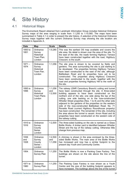
4. Site History<br />
4.1 Historical Maps<br />
The Envirocheck Report obtained from Landmark Information Group includes historical Ordnance<br />
Survey maps of the area ranging in scale from 1:1,250 to 1:10,560. The maps have been<br />
summarised in Table 4.1 in order to present the site history. A selection of the historical Ordnance<br />
Survey maps together with the current Ordnance Survey map showing the site location are<br />
included in Appendix A.<br />
Date Map Scale Details<br />
1850 to<br />
1851<br />
Ordnance<br />
Survey<br />
Historical<br />
Town Plan.<br />
London<br />
1:5,280 This was the earliest OS map available and covers the<br />
site area. No detail is shown over the area of the site. To<br />
the east of the site, the roads forming Highbury Terrace<br />
have been constructed together with the road, Highbury<br />
Crescent, to the south.<br />
1871 –<br />
1874<br />
Ordnance<br />
Survey<br />
Historical<br />
Town Pan.<br />
London<br />
1:1,056 The site area is shown to be covered by fields and<br />
gardens. The area surrounding the site is just starting to<br />
be developed. The properties forming Highbury Terrace<br />
have been constructed to the east of the site, although<br />
Battledean Road and its properties have yet to be<br />
constructed. The properties along Highbury Crescent<br />
have been constructed to the south, together with the<br />
road and properties forming Highbury Hill to the north of<br />
the site.<br />
1895 to<br />
1896<br />
Ordnance<br />
Survey<br />
Historical<br />
Town Plans<br />
London<br />
1:1,056<br />
and<br />
1:2,500<br />
The railway (GNR Canonbury Branch) cutting and tunnel<br />
have been constructed through the site. A three-sided<br />
building appears to have been constructed on the<br />
northern end of the site; one side along the top of the<br />
cutting, one side backing on to the now-constructed<br />
Whistler Street properties (Nos. 1 to 8) and the other side<br />
adjacent to the gardens of the properties on the western<br />
side of the now-constructed Battledean Road. No. 71<br />
Ronalds Road (current Highbury Roundhouse property)<br />
has been constructed. The remainder of the site, including<br />
the area above the tunnel is vacant. Arvon Road and its<br />
properties have been constructed on the western side of<br />
the railway cutting.<br />
1915 to<br />
1916<br />
Ordnance<br />
Survey<br />
County<br />
Series<br />
London<br />
1:2,500 The three-sided building on the site is named as a Glass<br />
Bottle Works. A timber yard is identified between Whistler<br />
Street and the top of the railway cutting. Otherwise little<br />
change from previous map.<br />
1936<br />
and<br />
1938<br />
Ordnance<br />
Survey<br />
County<br />
Series -<br />
London<br />
1:2,500<br />
and<br />
1:1,056<br />
A chimney is shown in the area enclosed by the threesided<br />
Bottle Works. The main area of the Bottle Works<br />
has increased and now has a similar footprint to the<br />
present day Youth and Community Centre.<br />
1954 Ordnance<br />
Survey Plan<br />
1:1,250 The Bottle Works is now a Packing Case Factory. Two<br />
buildings are shown on the site above the line of the<br />
tunnel.<br />
1971 to<br />
1980<br />
Ordnance<br />
Survey Plan<br />
1:1,250 The Packing Case Factory is now shown as a Youth<br />
Centre and the size of the building footprint appears to<br />
have increased. The buildings above the line of the tunnel<br />
5044006/002 <strong>Geotechnical</strong> <strong>Desk</strong> <strong>Study</strong> (2).doc 11