Geotechnical Desk Study - Islington Council
Geotechnical Desk Study - Islington Council
Geotechnical Desk Study - Islington Council

You also want an ePaper? Increase the reach of your titles
YUMPU automatically turns print PDFs into web optimized ePapers that Google loves.
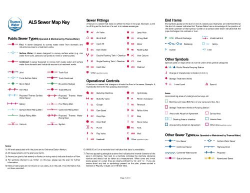
ALS Sewer Map Key<br />
Sewer Fittings<br />
A feature in a sewer that does not affect the flow in the pipe. Example: a vent<br />
is a fitting as the function of a vent is to release excess gas.<br />
AV<br />
Air Valve<br />
LH<br />
Lamp Hole<br />
End I tems<br />
End symbols appear at the start or end of a sewer pipe. Examples: an Undefined End at<br />
the start of a sewer indicates that Thames Water has no knowledge of the position of<br />
the sewer upstream of that symbol, Outfall on a surface water sewer indicates that the<br />
pipe discharges into a stream or river.<br />
Public Sewer Types(Operated & Maintained by Thames Water)<br />
BS<br />
Blind Shaft<br />
LS<br />
Lifting Shaft<br />
STW<br />
Effluent Discharge<br />
Undefined End<br />
Foul: A sewer designed to convey waste water from domestic and<br />
industrial sources to a treatment works.<br />
Surface Water: A sewer designed to convey surface water (e.g. rain<br />
water from roofs, yards and car parks) to rivers or watercourses.<br />
Combined: A sewer designed to convey both waste water and surface<br />
water from domestic and industrial sources to a treatment works.<br />
CP<br />
DC<br />
DF<br />
SF<br />
HB<br />
Cat ch Pit<br />
Dam Chase<br />
Double Flushing Tank / Chamber<br />
Single Flushing Tank / Chamber<br />
Hatch Box<br />
M<br />
ME<br />
RE<br />
VC<br />
VT<br />
WO<br />
Meter<br />
Rodding Eye<br />
Vent Column<br />
Vent<br />
Washout<br />
SA /<br />
Outfall<br />
SA Soakaway<br />
Inlet<br />
Gulley<br />
Other Symbols<br />
Symbols used on maps which do not fall under other general categories<br />
/ /<br />
Public/ Private Pumping Station<br />
GU<br />
Joint<br />
Trunk Foul<br />
Other (specified on plan)<br />
Change of characteristic indicator (C.O.C.I .)<br />
VACUUM<br />
Trunk Surface Water<br />
St orm Reli ef<br />
Vent Pipe<br />
Proposed Thames Surface<br />
Water Sewer<br />
Gallery<br />
Surface Water Rising Main<br />
Sludge Rising Main<br />
Vacuum<br />
SYPHON<br />
Trunk Combined<br />
Bio-solids (Sludge)<br />
Trade Effluent<br />
Proposed Thames Water<br />
Foul Sewer<br />
Foul Rising Main<br />
Combined Rising Main<br />
Proposed Thames Water<br />
Ri si ng Mai n<br />
Syphon<br />
Operational Controls<br />
A feature in a sewer that changes or diverts the flow in the sewer. Example: A<br />
hydrobrake limits the flow passing downstream.<br />
BD<br />
BV<br />
CL<br />
DB<br />
DP<br />
DS<br />
FL<br />
Backdrop Manhole<br />
Butt erfly Valve<br />
Clough<br />
Dam Board<br />
Drop Pipe<br />
Drop Shaft<br />
Flume<br />
PI<br />
HY<br />
PI<br />
PS<br />
RV<br />
ST<br />
SV<br />
TA<br />
Hydrobrake<br />
Petrol Interceptor<br />
Penst ock<br />
Ref lux Valve<br />
St ep<br />
Slui ce Valve<br />
Tank<br />
Sewage Treat ment Works<br />
IL<br />
I nvert Level<br />
Areas<br />
Lines denoting areas of underground surveys, etc.<br />
Summit<br />
Building over Case (BOC No.) or Low Lying Land (LLL No.)<br />
Sewage Treatment Works or Pumping Station<br />
Area under Adoption Agreement<br />
Drawing Area or chamber<br />
Area pending Adoption Agreement<br />
Survey Area<br />
Licence Area<br />
Other Area (specified on plan)<br />
FV<br />
Flap Valve<br />
WW<br />
Weir<br />
Other Sewer Types(Not Operated or Maintained by Thames Water)<br />
HW<br />
Headwall<br />
Other (specified on plan)<br />
Foul Sewer<br />
Surface Water Sewer<br />
Notes:<br />
1) All levels associated with the plans are to Ordnance Datum Newlyn.<br />
2) All measurements on the plans are metric.<br />
3) Arrows (on gravity fed sewers) or flecks (on rising mains) indicate direction of flow.<br />
4) For symbols referred to as ‘Other’ on this key, please see the plan for further<br />
information.<br />
5) Most private pipes are not shown on our plans, as in the past, this information has<br />
not been recorded.<br />
6) -9999.00 or 0 on a manhole level indicates that data is unavailable.<br />
7) The text appearing alongside a sewer line indicatesthe internal diameter of the<br />
pipe in milimetres. Text next to a manhole indicates the manhole reference<br />
number and should not be taken as a measurement. When cover and invert<br />
levels appear on a plan they are clearly prefixed by ‘CL’ and ‘I L’. I f you are<br />
unsure about any text or symbology present on the plan, please contact a<br />
member of Property I nsight on 0118 925 1504.<br />
Combined Sewer<br />
Culverted Watercourse<br />
Status Unknown<br />
Highway Drain<br />
Proposed<br />
Abandoned Sewer<br />
Page 7 of 10