- Page 1 and 2: POST TSUNAMI “GREEN” ENVIRONMEN
- Page 3 and 4: Post Tsunami “Green” Environmen
- Page 5 and 6: Acknowledgements Wetlands Internati
- Page 7 and 8: DAS Dephut DKP Ditjen Pankim-Deptra
- Page 9 and 10: Contents Page PREFACE .............
- Page 11 and 12: LIST OF TABLES Table 1. List of DCA
- Page 13 and 14: LIST OF ANNEXES Annex 1. List of St
- Page 15 and 16: 1. Introduction 1.1. BACKGROUND AND
- Page 17 and 18: No. Activity Time Location Descript
- Page 19 and 20: 3. Results and Discussion 3.1 GENER
- Page 21 and 22: Kabupaten Simeulue Kabupaten Simeul
- Page 23 and 24: The characteristics and types of ag
- Page 25 and 26: Vegetables Cultivation in NAD Provi
- Page 27 and 28: Damage Caused by the Tsunami So
- Page 29: Table 3. Coral Reef: Location and D
- Page 33 and 34: The tsunami not only devastated the
- Page 35 and 36: Formations found on sandy beaches a
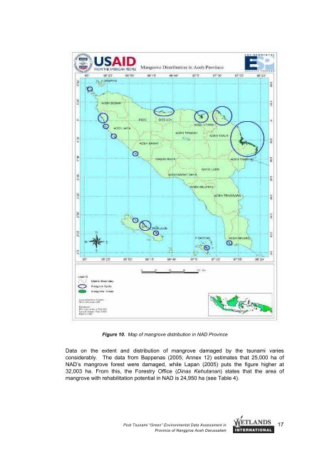
- Page 37 and 38: 3.4 FORESTRY AND BIODIVERSITY Colle
- Page 39 and 40: Under the provisions of Law No. 5 o
- Page 41 and 42: Leuser Ecosystem The Leuser Ecosyst
- Page 43 and 44: 3.4.3 Disturbances/Pressures on For
- Page 45 and 46: 3.4.4 Some Results of Disturbances/
- Page 47 and 48: Amphibians In a dedicated study, Mi
- Page 49 and 50: Stakeholders are divided into three
- Page 51 and 52: 4. Discussion and Evaluation 4.1 CO
- Page 53 and 54: Bagian Lingkungan Hidup Sekretariat
- Page 55 and 56: BPS, 2003; Aceh Dalam Angka - Aceh
- Page 57 and 58: FAO, 2005. Framework for Soil Recla
- Page 59 and 60: Pemerintah Kabupaten Daerah Tingkat
- Page 61 and 62: Suryadiputra, I N. N. (Editor). 200
- Page 63 and 64: Sinar Tani, 2005. Konsep Tata Ruang
- Page 65 and 66: 18 Duka dan Nestapa Mendominasi Sit
- Page 67 and 68: Annex 1. List of Stakeholders conta
- Page 69 and 70: Table 2. List of International Non-
- Page 71 and 72: Annex 2. List of Literature on the
- Page 73 and 74: No Author/Organisation/Institution
- Page 75 and 76: No Author/Organisation/Institution
- Page 77 and 78: No Author/Organisation/Institution
- Page 79 and 80: No Author/Organisation/Institution
- Page 81 and 82:
No Author/Organisation/Institution
- Page 83 and 84:
No Author/Organisation/Institution
- Page 85 and 86:
No Author/Organisation/Institution
- Page 87 and 88:
No Author/Organisation/Institution
- Page 89 and 90:
No. Institution Contact Person; Add
- Page 91 and 92:
No. Institution Contact Person; Add
- Page 93 and 94:
Texture Extract 1:5 Dry Samples 105
- Page 95 and 96:
Annex 4. Assessment Criteria for Ch
- Page 97 and 98:
Annex 6. Agriculture Pre- and Post-
- Page 99 and 100:
Annex 7. Production of Rice and Sec
- Page 101 and 102:
Annex 10. Fishing Statistics Pre-Ts
- Page 103 and 104:
NO Source Commodity Condition Remar
- Page 105 and 106:
NO Source Commodity Condition Remar
- Page 107 and 108:
NO Source Commodity Condition Remar
- Page 109 and 110:
NO Source District/Village Producti
- Page 111 and 112:
NO Source District/Village Producti
- Page 113 and 114:
Annex 12. Wetlands Statistics Table
- Page 115 and 116:
NO Source Condition Remarks 1 2 3 4
- Page 117 and 118:
NO Source Lake Name Commodity Area
- Page 119 and 120:
NO Source District Village Commodit
- Page 121 and 122:
NO Source River Name Condition Rema
- Page 123 and 124:
NO Source Type Condition Remarks 1
- Page 125 and 126:
Table 6. Sandy Beach Statistics: Pr
- Page 127 and 128:
NO Source Commodity Condition Remar
- Page 129 and 130:
NO Source Commodity Condition Remar
- Page 131 and 132:
Table 8. Freshwater Aquaculture Sta
- Page 133 and 134:
NO Source Type Commodity Condition
- Page 135 and 136:
NO Source Type Commodity Condition
- Page 137 and 138:
Annex 13. Forest Cover Table 1. For
- Page 139 and 140:
Annex 14. Conservation Forest in NA
- Page 141 and 142:
Annex 16. Land Use and Status in Na
- Page 143 and 144:
District/town Kecamatan (sub-distri
- Page 145 and 146:
Land Use in NAD Province Agricultur
- Page 147 and 148:
No. Family Si Aceh English Name St
- Page 149 and 150:
No. Family Si Aceh English Name St
- Page 151 and 152:
No. Family Scientific Name Author E
- Page 153 and 154:
Local Name Family Scientific Name 1
- Page 155 and 156:
Table 5. List of Mammal Species No.
- Page 157 and 158:
No. Indonesian Name Scientific Name
- Page 159 and 160:
Family/Species Coll Common Name Abu
- Page 161 and 162:
Family/Species Coll Common Name Abu
- Page 163 and 164:
Table 2. List of Donors Involved in
- Page 165 and 166:
No. Organisation Name Email Address
- Page 167 and 168:
No. Organisation Name Email Address
- Page 169 and 170:
No. Organisation Name Email Address
- Page 171 and 172:
No. Organisation Name Email Address
- Page 173 and 174:
No. Organisation Name Email Address
- Page 175 and 176:
Annex 19. List of Environmental Reh
- Page 177 and 178:
No Organisation District /Location
- Page 179 and 180:
No Organisation District /Location
- Page 181 and 182:
No Organisation District /Location
- Page 183 and 184:
No Organisation District /Location
- Page 185 and 186:
No Organisation District /Location
- Page 187 and 188:
No Organisation District /Location
- Page 189 and 190:
No Organisation District /Location
- Page 191 and 192:
No Organisation District /Location
- Page 193 and 194:
No Organisation District /Location
- Page 195:
No Organisationi District /Location