
Create successful ePaper yourself
Turn your PDF publications into a flip-book with our unique Google optimized e-Paper software.
L. D. PETERSEN, F. K. DUENNEBIER, T. H. SHIPLEY<br />
156°E 157 C<br />
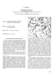
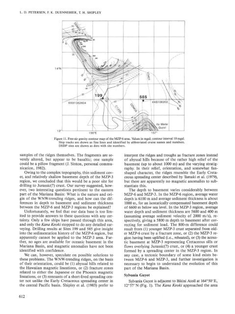
Figure 11. Free-air gravity contour map of the MZP-6 area. Values in mgal; contour interval 10 mgal.<br />
Ship tracks are shown as fine lines and identified by abbreviated cruise names and numbers.<br />
DSDP sites are shown as dots with site numbers.<br />
samples of the ridges themselves. The fragments are severely<br />
altered, but appear to be basaltic; one sample<br />
could be a pillow fragment (J. Sinton, personal communication,<br />
1982).<br />
Owing to the complex topography, thin sediment cover,<br />
and relatively shallow basement depth of the MZP-3<br />
region, we concluded that this would be a poor site for<br />
drilling to Jurassic(?) crust. Our survey suggested, however,<br />
two interesting questions pertinent to the eastern<br />
part of the Mariana Basin: What is the nature and origin<br />
of the WNW-trending ridges, and how can the differences<br />
in depth to basement and sediment thickness<br />
between the MZP-6 and MZP-3 regions be explained?<br />
Unfortunately, we feel that our data base is too limited<br />
to provide answers to these questions with any certainty.<br />
Only a few ships have passed through this area,<br />
and only the Rana Keoki stopped to do any detailed surveying.<br />
<strong>Drilling</strong> results at Sites 199 and 585 give insight<br />
into the sedimentation history of the MZP-6 region, but<br />
apparently cannot be applied to the MZP-3 area. Further,<br />
no ages are available for oceanic basement in the<br />
Mariana Basin, and magnetic anomalies have not been<br />
identified with confidence.<br />
We can, however, speculate on possible solutions to<br />
these problems. The WNW-trending ridges, on the basis<br />
of their orientation, could be (1) abyssal hills related to<br />
the Hawaiian magnetic lineations, or (2) fracture zones<br />
related to either the Japanese or the Phoenix magnetic<br />
lineations, or (3) remnants of a short-lived spreading center<br />
not unlike the Early Cretaceous spreading center in<br />
the central Pacific basin. Shipley et al. (1983) prefer to<br />
612<br />
interpret the ridges and troughs as fracture zones instead<br />
of abyssal hills because of the rather high relief of the<br />
basement (up to about 1000 m) and the varying stratigraphy.<br />
In their relief, orientation, and somewhat fanshaped<br />
character, the ridges resemble the Early Cretaceous<br />
spreading center described by Tamaki et al. (1979),<br />
but there are apparently no magnetic anomalies to substantiate<br />
this.<br />
The depth to basement varies considerably between<br />
MZP-6 and MZP-3. In the MZP-6 region, average water<br />
depth is 6100 m and average sediment thickness is about<br />
1000 m, for an isostatically compensated basement depth<br />
of 6600 m below sea level. In the MZP-3 region, average<br />
water depth and sediment thickness are 5600 and 400 m<br />
(assuming average sediment velocity of 2000 m/s), respectively,<br />
giving a 5800 m depth to basement after correcting<br />
for sediment load. The 800-m difference could<br />
result from (1) younger MZP-3 crust separated from older<br />
MZP-6 crust by a fracture zone, or (2) the MZP-3 region<br />
having been uplifted (i.e., reheated), or (3) the acoustic<br />
basement at MZP-3 representing Cretaceous sills or<br />
flows overlying Jurassic(?) crust, or (4) a younger crust<br />
formed by a spreading center in the MZP-3 region. In<br />
any case, a tectonic boundary of some kind exists between<br />
MZP-6 and MZP-3, and further investigation is<br />
necessary to begin to understand the evolution of this<br />
part of the Mariana Basin.<br />
Sylvania Guyot<br />
Sylvania Guyot is adjacent to Bikini Atoll at 164°50'E,<br />
12°57'N (Fig. 1). The Kana Keoki approached the area