
Create successful ePaper yourself
Turn your PDF publications into a flip-book with our unique Google optimized e-Paper software.
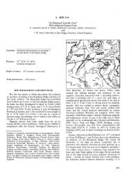
L. D. PETERSEN, F. K. DUENNEBIER, T. H. SHIPLEY<br />
140° 150 160° 170° 180° 150° 160° 170°E<br />
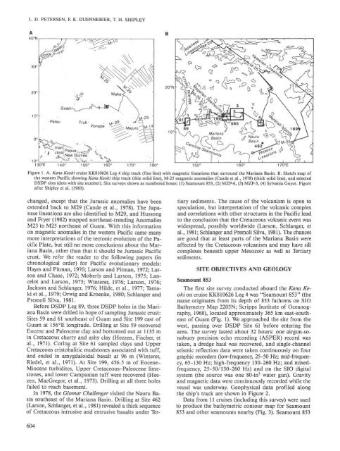
Figure 1. A. Kana Keoki cruise KK810626 Leg 4 ship track (fine line) with magnetic lineations that surround the Mariana Basin. B. Sketch map of<br />
the western Pacific showing Kana Keoki ship track (thin solid line), M-25 magnetic anomalies (Cande et al., 1978) (thick solid line), and selected<br />
DSDP sites (dots with site number). Site surveys shown as numbered boxes: (1) <strong>Sea</strong>mount 853, (2) MZP-6, (3) MZP-3, (4) Sylvania Guyot. Figure<br />
after Shipley et al. (1983).<br />
changed, except that the Jurassic anomalies have been<br />
extended back to M29 (Cande et al., 1978). The Japanese<br />
lineations are also identified to M29, and Hussong<br />
and Fryer (1982) mapped northeast-trending Anomalies<br />
M23 to M25 northeast of Guam. With this information<br />
on magnetic anomalies in the western Pacific came many<br />
more interpretations of the tectonic evolution of the Pacific<br />
Plate, but still no more conclusions about the Mariana<br />
Basin, other than that it should be Jurassic Pacific<br />
crust. We refer the reader to the following papers (in<br />
chronological order) for Pacific evolutionary models:<br />
Hayes and Pitman, 1970; Larson and Pitman, 1972; Larson<br />
and Chase, 1972; Moberly and Larson, 1975; Lancelot<br />
and Larson, 1975; Winterer, 1976; Larson, 1976;<br />
Jackson and Schlanger, 1976; Hilde, et al., 1977; Tamaki<br />
et al., 1979; Orwig and Kroenke, 1980; Schlanger and<br />
Premoli Silva, 1981.<br />
Before DSDP Leg 89, three DSDP holes in the Mariana<br />
Basin were drilled in hope of sampling Jurassic crust:<br />
Sites 59 and 61 southeast of Guam and Site 199 east of<br />
Guam at 156°E longitude. <strong>Drilling</strong> at Site 59 recovered<br />
Eocene and Paleocene clay and bottomed out at 1135 m<br />
in Cretaceous cherty and ashy clay (Heezen, Fischer, et<br />
al., 1971). Coring at Site 61 sampled clays and Upper<br />
Cretaceous cristobalitic mudstones associated with tuff,<br />
and ended in amygdaloidal basalt at 96 m (Winterer,<br />
Riedel, et al., 1971). At Site 199, 456.5 m of Eocene-<br />
Miocene turbidites, Upper Cretaceous-Paleocene limestones,<br />
and lower Campanian tuff were recovered (Heezen,<br />
MacGregor, et al., 1973). <strong>Drilling</strong> at all three holes<br />
failed to reach basement.<br />
In 1978, the Glomar Challenger visited the Nauru Basin<br />
southeast of the Mariana Basin. <strong>Drilling</strong> at Site 462<br />
(Larson, Schlanger, et al., 1981) revealed a thick sequence<br />
of Cretaceous intrusive and extrusive basalts under Ter-<br />
604<br />
tiary sediments. The cause of the volcanism is open to<br />
speculation, but interpretation of the volcanic complex<br />
and correlations with other structures in the Pacific lead<br />
to the conclusion that the Cretaceous volcanic event was<br />
widespread, possibly worldwide (Larson, Schlanger, et<br />
al., 1981; Schlanger and Premoli Silva, 1981). The chances<br />
are good that at least parts of the Mariana Basin were<br />
affected by the Cretaceous volcanism and may have sill<br />
complexes beneath upper Mesozoic as well as Tertiary<br />
sediments.<br />
<strong>Sea</strong>mount 853<br />
SITE OBJECTIVES AND GEOLOGY<br />
The first site survey conducted aboard the Kana Keoki<br />
on cruise KK810626 Leg 4 was "<strong>Sea</strong>mount 853" (the<br />
name originates from its depth of 853 fathoms on SIO<br />
Bathymetry Map 2203N; Scripps Institute of Oceanography,<br />
1968), located approximately 365 km east-southeast<br />
of Guam (Fig. 1). We approached the site from the<br />
west, passing over DSDP Site 61 before entering the<br />
area. The survey lasted about 32 hours: one airgun-sonobuoy<br />
precision echo recording (ASPER) record was<br />
taken, a dredge haul was recovered, and single-channel<br />
seismic reflection data were taken continuously on four<br />
graphic recorders (low-frequency, 25-50 Hz; mid-frequency,<br />
65-130 Hz; high-frequency 130-260 Hz; and mixedfrequency,<br />
25-50/130-260 Hz) and on the SIO digital<br />
system (the source was one 80-in 3 water gun). Gravity<br />
and magnetic data were continuously recorded while the<br />
vessel was underway. Geophysical data profiled along<br />
the ship's track are shown in Figure 2.<br />
Data from 11 cruises (including this survey) were used<br />
to produce the bathymetric contour map for <strong>Sea</strong>mount<br />
853 and other seamounts nearby (Fig. 3). <strong>Sea</strong>mount 853