Create successful ePaper yourself
Turn your PDF publications into a flip-book with our unique Google optimized e-Paper software.
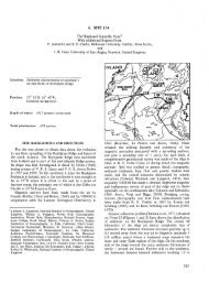
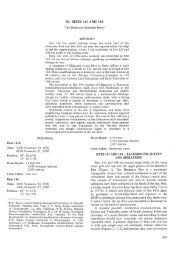
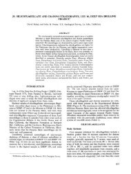
12°30'N<br />
11 °30'<br />
164°30'E 165°<br />
SITE SURVEYS IN THE WESTERN PACIFIC<br />
Figure 22. Free-air gravity contour map of Sylvania <strong>Sea</strong>mount. Values are in mgal; contour intervals 10 mgal.<br />
Only data from cruise KK810626 Leg 4 (track shown as fine line) were used to make this map.<br />
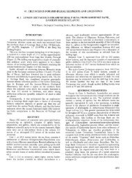
B NW<br />
1<br />
2<br />
2 3<br />
"5.<br />
8 4<br />
7<br />
164°E 166° -250 km<br />
5<br />
6<br />
- / V /<br />
/<br />
/ Basalt<br />
j<br />
Reef 1<br />
\ •<br />
SE<br />
<strong>Sea</strong> level<br />
- 1000<br />
2000 _<br />
E<br />
- 3000<br />
- 4000<br />
- 5000<br />
Figure 23. A. Sketch of bathymetry of Sylvania and Bikini. Contours are in seconds. Cross section along the NW-SE line is shown in (B). B.<br />
Cross section of Sylvania and Bikini along NW-SE line in (A). This shows the depth to volcanic basement is about the same at both Sylvania<br />
and Bikini, but the thickness of the reef cap is markedly different.<br />
623