
Create successful ePaper yourself
Turn your PDF publications into a flip-book with our unique Google optimized e-Paper software.
L. D. PETERSEN, F. K. DUENNEBIER, T. H. SHIPLEY<br />
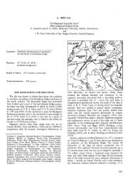
148°E<br />
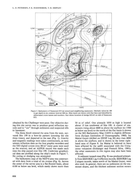
Figure 3. Bathymetry of <strong>Sea</strong>mount 853 (at center) and neighboring seamounts. Multiply values by 100<br />
to get depth in ms; contour interval 200 ms. Ship tracks are shown with fine lines and identified by<br />
abbreviated cruise names and numbers. Star shows location of dredge RD-65 on side of <strong>Sea</strong>mount<br />
853.<br />
obtained by the Challenger were poor. Our objective during<br />
this site survey was to produce good reflection records<br />
and to "see" through sediments and suspected sills<br />
to basement.<br />
The Kana Keoki entered the area from the west, surveyed<br />
Site 199 in a bow-tie pattern (crossing the site<br />
three times), and departed to the east (Fig. 1). Gravity<br />
and magnetic readings were taken continuously, as were<br />
seismic reflection data on the four graphic recorders and<br />
the SIO digital system (two 80-in 3 water guns were used<br />
as the source), and an ASPER record was made each<br />
time the ship passed over Site 199. Underway geophysical<br />
data are profiled along the ship's track in Figure 7.<br />
No coring or dredging was attempted.<br />
The bathymetry map of the MZP-6 area was constructed<br />
with data from a total of six cruises (Fig. 8). Across<br />
the center of the survey area is a flat-floored basin, about<br />
6100 m below sea level, which rarely shows more than<br />
606<br />
30 m of relief. One pinnacle 1050 m high is located<br />
about 15 km southwest of Site 199. A cluster of seamounts<br />
rising about 4600 m above the seafloor (to 1500<br />
m below sea level) to the north of the flat basin is shown<br />
on the SIO Bathymetry Map 2103N in slightly different<br />
form (Scripps Institution of Oceanography, 1968). Ita<br />
Maitai Guyot (drilled on DSDP Leg 20) also rises 4600<br />
m above the seafloor, and is shown in the lower righthand<br />
area of Figure 8. Ita Maitai is believed to have<br />
been affected by the uplift associated with the Cretaceous<br />
volcanism (Schlanger and Premoli Silva, 1981);<br />
the other seamounts in this region may also have been<br />
affected.<br />
A sediment isopach map (Fig. 9) was produced primarily<br />
from KK810626 Leg 4 reflection records; KK810626 Leg<br />
2 airgun records, taken north of Ita Maitai Guyot, were<br />
also used. In general, there are no sediments on the seamount<br />
slopes, and the thickest sediment section occurs